It was one of those things that was up in the air. Harry Haywood, the man who developed the idea of the "Black Belt Nation", said that African-Americans had the right to self-determination up to and including secession. So at best it looks like it would be akin to an autonomous republic (ASSR) but with independence not ruled out.It has been years that I last read on this, but was this proposed to be an independent/sovereign state, or an autonomous state/chain of autonomous states within US jurisdiction? sort of like an American equivalent of the ethnic minority republics of Russia?
You are using an out of date browser. It may not display this or other websites correctly.
You should upgrade or use an alternative browser.
You should upgrade or use an alternative browser.
Proposals and War Aims That Didn't Happen Map Thread
- Thread starter Beedok
- Start date
Would it be possible for the USSR to create a state on this tinier area?
This is probably more of a Karl Renner type situation. That area is too small to be viable, like the Soviet occupation zone in Austria, and the best hope there was to set up a neutral cabinet acceptable to the WAllies but neutral in the long term. At least they would try, might not work in the long run.
Speaking of Austria, are you guys aware of any plans to merge the Soviet occupation zone of Austria with the one in Germany?They would almost certainly have a go at it if needed.
I'm not capable of providing sources for accurate determination but according to my uncle and father, my grandfather (who was a commisar but idk his specific rank or really all that much about him) after being transferred from the Soviet front (as in army group) that attacked Berlin from the south the name of the general escapes me but I'm certain it wasn't Zhukov.... anywho he was posted in Austria as part of the Soviet occupation and thought that it was incredibly lovely and that it was an "insult to communism and the Motherland to ever let it go" from Soviet control. I think he met my grandmother there so maybe he just liked the women and I can't fault him because Austria is beautiful and pretty awesome but other than that anecdote I don't really know of any official plans to keep it or assign it to one of the Soviet puppets or anything.Speaking of Austria, are you guys aware of any plans to merge the Soviet occupation zone of Austria with the one in Germany?
I think there is only timeline here where Stalin did attach the Soviet Austrian occupation zone to the Soviet German occupation zone and the western Allies did the same with their part.I'm not capable of providing sources for accurate determination but according to my uncle and father, my grandfather (who was a commisar but idk his specific rank or really all that much about him) after being transferred from the Soviet front (as in army group) that attacked Berlin from the south the name of the general escapes me but I'm certain it wasn't Zhukov.... anywho he was posted in Austria as part of the Soviet occupation and thought that it was incredibly lovely and that it was an "insult to communism and the Motherland to ever let it go" from Soviet control. I think he met my grandmother there so maybe he just liked the women and I can't fault him because Austria is beautiful and pretty awesome but other than that anecdote I don't really know of any official plans to keep it or assign it to one of the Soviet puppets or anything.
Does anybody knows what do these "border regions" were supposed to be? would they be a part of the Black Belt Nation like what territories are to the US?View attachment 839603
Not sure if it's 100% accurate, but an effort was made.
Not really a 90 degree angle, but the boundaries of Levy and Marion counties to which eastern Marion meets the St. Johns RiverBesides you accidentally not filling in that bit of land in southern Maryland and Virginia just south of it with a darker shade, I would say it is spot on. Well, there is the thing in Flordia, but your map looks more organic than that 90 degree angle.
Also could anyone try making this on WorldA?View attachment 839603
Not sure if it's 100% accurate, but an effort was made.
Someone already made it, but you may need to scroll down.
Proposals and War Aims That Didn't Happen Map Thread
No idea what the internal borders would be so feel free to make as many guesses as you wish. At leat for the first years of the Federation, it would most likely retain the borders of the constituent countries.
www.alternatehistory.com
Thanks, reposting the map by @Mumby here for convenienceSomeone already made it, but you may need to scroll down.
Proposals and War Aims That Didn't Happen Map Thread
No idea what the internal borders would be so feel free to make as many guesses as you wish. At leat for the first years of the Federation, it would most likely retain the borders of the constituent countries.www.alternatehistory.com
But I will ask again: What exactly are these "border regions" supposed to be? autonomous territories of the Black Belt Nation? joint US-BBN condominiums? areas that could or could not join the BBN?
My guess is that the border territories represent counties that have a sizeable Black population, but are not necessarily in the majority.Thanks, reposting the map by @Mumby here for convenience

But I will ask again: What exactly are these "border regions" supposed to be? autonomous territories of the Black Belt Nation? joint US-BBN condominiums? areas that could or could not join the BBN?
So they would still nonetheless be a part of the BBN or no?My guess is that the border territories represent counties that have a sizeable Black population, but are not necessarily in the majority.
Depends on how you're making things go down i whatever timeline you're working on.So they would still nonetheless be a part of the BBN or no?
Thanks, reposting the map by @Mumby here for convenience
But I will ask again: What exactly are these "border regions" supposed to be? autonomous territories of the Black Belt Nation? joint US-BBN condominiums? areas that could or could not join the BBN?
So as far as I can tell, the ‘border territory’ is adjoining territory which still has significant albeit minority Black population, and is intended as contrast to demonstrate how American Capitalism has exploited an imprisoned Black Nation.
So would this territory be a part of the BBN or no? this is what I wanna know.So as far as I can tell, the ‘border territory’ is adjoining territory which still has significant albeit minority Black population, and is intended as contrast to demonstrate how American Capitalism has exploited an imprisoned Black Nation.
Last edited:
Like I said before, it's one of those things that's up in the air. That said, I do feel like it would have to be part of the BBN, if only because the BBN isn't really sustainable territorially without it.So would this territory be a part of the BBN or no? this is what I wanna know.
Oh sorry if I am being inconvenient here, and you're right, on a TL I am going to make the BBN into an autonomous state of the US proper.Like I said before, it's one of those things that's up in the air. That said, I do feel like it would have to be part of the BBN, if only because the BBN isn't really sustainable territorially without it.
But anyways, when I compared the BBN to the USSR's/Russia's ethnic minority ASSR's/Republics, I forgot to clarify that Harry Haywood, who lived in the Soviet Union and was also a member of the CPSU, got this idea for the Black Belt Nation from him visiting the ASSRs in the first place.
So, if Wikipedia is right, then Haywood already intended the BNN to serve as the American equivalent of a Soviet ASSR.During his four-and-half-year stay in the Soviet Union (1925–1930), Harry Haywood held dual membership in both the CPUSA and the CPSU. As a member of the CPSU, he traveled extensively in the Soviet Union's autonomous republics, and participated in the struggles against both the Left Opposition headed by Leon Trotsky and the Right Opposition led by Nikolai Bukharin. In these struggles and in others, Haywood was on the side of Joseph Stalin. While working as a delegate for the Comintern, he served on commissions dealing with the question of African Americans in the United States, as well as the development of the "Native Republic Thesis" for the South African Communist Party. Haywood worked to draft the "Comintern Resolutions on the Negro Question" of 1928 and 1930, which stated that African Americans in the Southern part of the United States made up an oppressed nation, with the right to self-determination up to and including secession. He would continue to fight for this position throughout his life.
He believed that a distinct African-American nation had developed that satisfied the criteria laid out by Stalin in his Marxism and the National Question: a historically constituted, stable community of people, formed on the basis of a common language, territory, economic life, and psychological makeup manifested in a common culture. Because African Americans in the South constituted such a nation, Haywood believed the correct response was a demand for self-determination, up to and including the right to separate from the United States. Their "national territory" was historically the South, and they deserved full equality everywhere else in the United States. Haywood believed that only with genuine political power, which from a Marxist point of view included control of the productive forces, such as land, could African Americans obtain genuine equality. Their gaining of equality was a prerequisite for broader working class unity.

Harry Haywood - Wikipedia
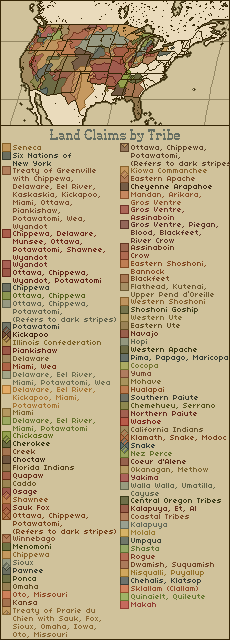
@EnjoyerofAlternateHistory made this beautiful map of Native American land claims that needs more attention:
The Twenty-Point Position Paper from the 1972 Trail of Broken Treaties protest, specifically #10So now, this makes me wonder something: have there been any Native American equivalents of the BBN, like Indian Reservations but with much bigger autonomy, as if they were states themselves?
Please don't feel like you're being "inconvenient", okay? It's natural to have questions about something like this, and it's good questions to have!Oh sorry if I am being inconvenient here, and you're right, on a TL I am going to make the BBN into an autonomous state of the US proper.
But anyways, when I compared the BBN to the USSR's/Russia's ethnic minority ASSR's/Republics, I forgot to clarify that Harry Haywood, who lived in the Soviet Union and was also a member of the CPSU, got this idea for the Black Belt Nation from him visiting the ASSRs in the first place.
So, if Wikipedia is right, then Haywood already intended the BNN to serve as the American equivalent of a Soviet ASSR.
So now, this makes me wonder something: have there been any Native American equivalents of the BBN, like Indian Reservations but with much bigger autonomy, as if they were states themselves?Harry Haywood - Wikipedia
en.wikipedia.org
So this map is maximum claims, and ignores the smaller tribes? I recall something about the members of none-Sioux Indian Reservations not being amused by the claim of their historical raiders to what was their own past or present land. Ahhh right, it is mentioned in link. We really need to make a thread in here somewhere about all of these university and library sites and all the wonderful images and maps they have in them, a shame it is difficult to zoom in on the image in the link, at least on an iPad. Speaking of, is the map you posted the original size they posted? Zooming in, everything looks blurry, though I suppose it could be an aesthetically choice for the colors, they really managed to get across the look of aged paper.@EnjoyerofAlternateHistory made this beautiful map of Native American land claims that needs more attention:
No it is not, this is a WorldA which looks very small already on this forum, I zoomed the map in myself, this is what the map looks like on its actual PNG size:Speaking of, is the map you posted the original size they posted? Zooming in, everything looks blurry, though I suppose it could be an aesthetically choice for the colors, they really managed to get across the look of aged paper.
And this is what the BBN looks like on the real PNG WorldA size:
Repeating again: I do not made either of these maps.
Share: