Warning
2022 Russian invasion of Ukraine - Wikipedia
 en.wikipedia.org
en.wikipedia.org
en.wikipedia.org
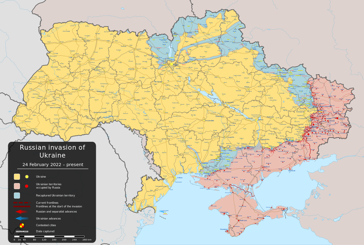
Keep contemporary issues out of this thread.Well it's starting2022 Russian invasion of Ukraine - Wikipedia
That's wild. I wonder if "Upper Hungary" would have eventually morphed into an early Slovakia.Two proposals regarding the Ottomans and Hungary:
1683
View attachment 721577
1529 (Not sure if this truly was a proposal)
View attachment 721579
View attachment 721580
yes none of the allies would have dared to offer Romania Bessarabia back in 1916 ☺The 1916 Treaty of Bucharest, showing what the Entente offered the Romanians to be in their side. While Bessarabia is shown in diagonal stripes here, it was not offered. If the map is to be believed (the Wikipedia page has more details) it seems they were offered more than they ended up getting from Hungary. I am guessing partially because they could have went for the names of entire regions, and Banat ended up split between Romania and Yugoslavia. Also looks like the Romanians got a bit of land north of Bukovina here.
View attachment 722350
Hmmm, odd coloring for those Arctic Islands. They are all in Arkhangelsk, and I can’t seem to find anything signifying they were not before the recent annexation of the Nenets area. I also have to say it is telling that St. Petersburg and Moscow don’t have letters when describing possible mergers. Maybe because it doesn’t have autonomous oblasts or non-ethnic Russians being swallowed up? Also a bit confusing with the mixed numbers in yellow north of Mongolia.
It's interesting to see what Napoleon sought to change from this given how he eventually ruled.Emmanuel Joseph Sieyès' draft constitution for the French Consulate as described by one of the people who saw it, Boulay de la Muerthe. Here is a link to where I found this, and here is a link with some additional information and thoughts on how it might have worked in practice.
The islands of Estonia have vanished
Maps of the planned zones for the 1920 Schleswig plebiscites, with the northern zone, in red, voting as a bloc and voting overwhelmingly to join Denmark, while the parishes in the pink central zone were supposed to each vote whether to join Denmark or to remain part of Germany, but none did. The plebiscite was never held in the southern zone as a result. The second map shows the percentage of the vote in each parish to join Denmark. There was actually a constitutional crisis in Denmark around Easter 1920 before the plebiscites resulting from the dismissal of the government by the Danish King Christian X, who agreed with many conservatives and Danish nationalists that central Schleswig should be returned to Denmark regardless of the results of the plebiscite, and believed that the elected government was not pushing hard enough for the territory to become part of Denmark. There was nearly a revolution which overthrew the Danish monarchy entirely until King Christian agreed to hold another general election, followed by amendments to the Danish constitution which got rid of most of the real power of the monarchy.
Certainly can't fault the Assyrians for lack of ambitionView attachment 727663 Thought I'd do this one.
View attachment 727667View attachment 727666View attachment 727664View attachment 727665 ... And here's some more proposals for post-ww2 borders.
")
ah yes, Danish Silesiaoh fuck that's not silesia
There'll be Danish Entre Rios if you aren't careful.ah yes, Danish Silesia


