You are using an out of date browser. It may not display this or other websites correctly.
You should upgrade or use an alternative browser.
You should upgrade or use an alternative browser.
OTL Election maps resources thread
- Thread starter Thande
- Start date

I'm afraid not, but Virginia was one of the few states to actually keep redistricting after every census, so it could have been far worse.Interesting to see the pre-Reynolds district lines - do you know how the populations of the various districts looked? I can imagine the disparities being somewhat horrific.
This is the motto of the American South, isn't it?it could have been far worse

Wallonia 2014. These are to be the last elections with these constituencies, as in 2017, ECOLO and the PTB challenged the electoral constituencies before the Constitutional Court arguing that they hindered the representativity of the Wallonian Parliament. They won. As a result, the Wallonian Parliament passed a new electoral map merging the constituencies of the Luxembourg province and reworking those of the Hainaut province. However, the new division only passed with the support of PS, MR and cdH. ECOLO and PTB remain opposed to the new map.
Also, the longer the constituency's name, the smaller the number of deputies it elected.

Also, the longer the constituency's name, the smaller the number of deputies it elected.
Just asking, is there a Maryland precinct map I can play with? I could make do with a county map if no precinct map is available.
Just asking, is there a Maryland precinct map I can play with? I could make do with a county map if no precinct map is available.
If you are just looking for a map to play around with, there is always DRA. However, if you want more recent precinct maps, I recommend @JZTessler on Twitter. If you want a file that can be opened in GIS, just google 'Maryland Precinct shapefile' and you will get Marylands official gis page, md.gov/imap
The reason I asked is because I can't seem to use DRA without my computer crashing. But @JZTessler provided usable data sets, so thank you for recommending him.If you are just looking for a map to play around with, there is always DRA. However, if you want more recent precinct maps, I recommend @JZTessler on Twitter. If you want a file that can be opened in GIS, just google 'Maryland Precinct shapefile' and you will get Marylands official gis page, md.gov/imap
Has anyone ever done a map of Austro-Hungarian elections? Is it even possible to attempt one?
Well, there were never Austro-Hungarian elections - there were Austrian (or Cisleithanian) ones, Hungarian ones, and Croatian ones. The latter have some decent maps on Wikipedia.Has anyone ever done a map of Austro-Hungarian elections? Is it even possible to attempt one?
Has anyone made a map of the European Parliament elections by subdivision in each country?
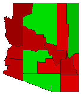
Apologies if this has been posted before, but I was really struck by how this 1990 Arizona Referendum on whether or not MLK day should be a state holiday lines up so closely with the 2018 Senate election - all the No counties went for McSally and all the Yes counties went for Sinema.
ST15RM
Banned
This is basically my reaction:Apologies if this has been posted before, but I was really struck by how this 1990 Arizona Referendum on whether or not MLK day should be a state holiday lines up so closely with the 2018 Senate election - all the No counties went for McSally and all the Yes counties went for Sinema.
Dose anyone have a or kniw where I can find the congressional results by state cumulative popular vote For the states that have officially certified their election results ( I’m looking at you North Carolina)? I know I could go to each states SoS site but I’d really rather not.
Witch0Winter
Banned
I suppose this doesn't quite count as easily modifiable with paint programs, but this is the only OTL election map thread I know, so apologies. This map is actually easily editable and able to play around with in QGIS, though, so feel free to ask me for files!
Anyway, here are the 2018 House of Representatives elections in the United States with a little bit of geographical and cultural flair on them in a different style I'm trying out. Hope it may be of interest to y'all. Enjoy! Done using QGIS with Natural Earth Data, National Map, and USGS data. PNG is over here because it's a very large file.

Anyway, here are the 2018 House of Representatives elections in the United States with a little bit of geographical and cultural flair on them in a different style I'm trying out. Hope it may be of interest to y'all. Enjoy! Done using QGIS with Natural Earth Data, National Map, and USGS data. PNG is over here because it's a very large file.
Alex Richards
Donor
Has anyone made a map of the European Parliament elections by subdivision in each country?
The difficulty here is that the results aren't released by subdivision consistently.
Witch0Winter
Banned
Another QGIS map! Again, since this is the resource thread, I'm happy to provide files for people who would like to try to make one of these themselves!
So, here is a map of the 2016 Democratic Presidential Primary between Former Secretary of State Hillary Clinton and Senator Bernie Sanders. With states not only being different in whether they do primaries or caucuses but in how they they do these results, I did my best to make the most complete map that displays each state in the way it is done best, as well as US territories (sorry Democrats Abroad, the world map didn't work out). I hope you all enjoy! PNG is here to download on deviantart.

So, here is a map of the 2016 Democratic Presidential Primary between Former Secretary of State Hillary Clinton and Senator Bernie Sanders. With states not only being different in whether they do primaries or caucuses but in how they they do these results, I did my best to make the most complete map that displays each state in the way it is done best, as well as US territories (sorry Democrats Abroad, the world map didn't work out). I hope you all enjoy! PNG is here to download on deviantart.
Share: