OTL Election maps resources thread

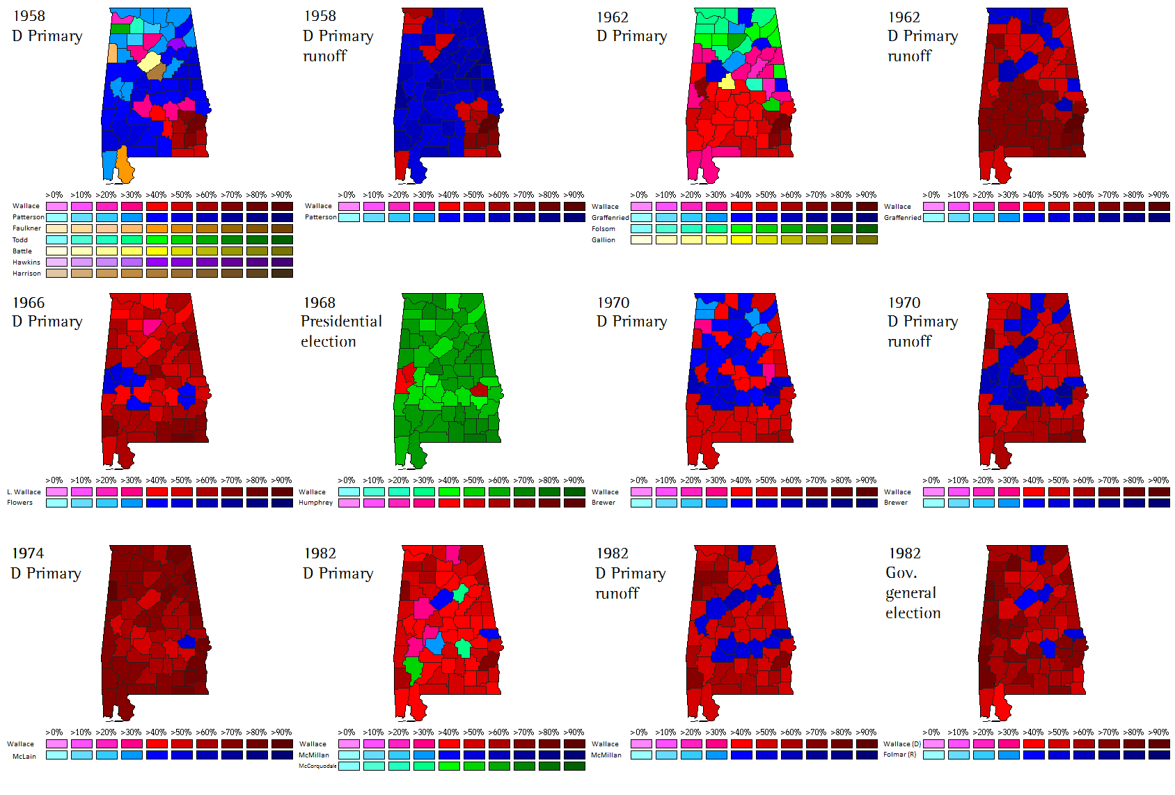
Found this map while I was randomly searching on Google Images.

A geographic list of all of the elections that George Wallace was a candidate in.

https://welections.wordpress.com/2011/02/22/a-geographical-history-of-george-wallace/

us-wallace-maps.png
 
Last edited:
It has come to my attention while reading through New York local election results that no one ran for supervisor in the town of Greenwood in Steuben County.

No one.

All 53 votes were write-ins.

Unfortunately, the town is in the middle of nowhere and I can't find any context online.

Edit: the same thing happened in the town of Pulteney (same county)

Double edit: and again in Troupsburg! (still same county)
 
Last edited:
Continuing with 19th century Dutch elections, here's 1891. If you compare it with the previous one, you can clearly see the Liberals made substantial gains, winning several seats from the Anti-Revolutionaries and even a previously Catholic seat. Both the last remaining Conservative seat and the sole Social Democratic seat also fell to the Liberals. As you might expect, the Liberals won a majority and formed a government after the election, promising to extend suffrage.

8Kku0Au.png
 
Yes. You can spot some provincial borders in these boundaries, but the boundaries were drawn specifically with the intention of crossing provincial borders so as to oppose provincialism and symbolise the fact that MPs were supposed to represent the whole nation, rather than their province.
 

Thande

Donor
It has come to my attention while reading through New York local election results that no one ran for supervisor in the town of Greenwood in Steuben County.

No one.

All 53 votes were write-ins.

Unfortunately, the town is in the middle of nowhere and I can't find any context online.

Edit: the same thing happened in the town of Pulteney (same county)

Double edit: and again in Troupsburg! (still same county)
This sort of thing happens quite a lot in rural Wales.
 
Yes. You can spot some provincial borders in these boundaries, but the boundaries were drawn specifically with the intention of crossing provincial borders so as to oppose provincialism and symbolise the fact that MPs were supposed to represent the whole nation, rather than their province.

That's very Dutch, and honestly kind of odd given that local representation is supposed to be one of the main assets of FPTP.
 
Yes. You can spot some provincial borders in these boundaries, but the boundaries were drawn specifically with the intention of crossing provincial borders so as to oppose provincialism and symbolise the fact that MPs were supposed to represent the whole nation, rather than their province.

*The US is just noise*
 
Very nice. I assume those were also the counties? Did the State House represent individual towns like in Massachusetts?
Yes, they were counties. There's record of some State House districts, but not all. The districts consisted of a few towns combined, except for in the case of towns like Portland.
 
Yes, they were counties. There's record of some State House districts, but not all. The districts consisted of a few towns combined, except for in the case of towns like Portland.

So they did have districts. Massachusetts famously gave at least one representative to each town, which meant that at the time Maine split off, the Massachusetts State House had almost 750 seats.
 
So they did have districts. Massachusetts famously gave at least one representative to each town, which meant that at the time Maine split off, the Massachusetts State House had almost 750 seats.
According to this article, they reached 749 seats in 1812, though they'd cooled off to 408 by 1819. So that's a really close estimate.
 
According to this article, they reached 749 seats in 1812, though they'd cooled off to 408 by 1819. So that's a really close estimate.

The historical estimates for the size of the U.S. House under the Wyoming rule tend to fluctuate to similarly ridiculous extents - by the peak in 1900, it would've had 1,862 seats. This is of course because Nevada was still ridiculously small by then, even half a century after it got statehood with all the growth that meant for the rest of the country.
 

Thande

Donor
So they did have districts. Massachusetts famously gave at least one representative to each town, which meant that at the time Maine split off, the Massachusetts State House had almost 750 seats.
Does the crown of Absurdly Large Legislature just get passed around between the New England states? By the year 2214, will Rhode Island have more representatives than it has citizens?
 
I mentioned in my last post that in 1891, a Liberal government was installed with the promise of expanding suffrage. Sure enough, the next year, Minister of the Interior Johannes Tak van Poortvliet introduced a bill that would effectively have implemented universal male suffrage, barring only the illiterate and beggars from the vote. MPs thought this proposal too ambitious, and some critical amendments were adopted, prompting the cabinet to dissolve Parliament and call for a snap election, hoping to win support for the original bill. The whole 1894 election revolved around the suffrage question. The political landscape split into "Takkians", who supported the expansion of suffrage, and "Anti-Takkians", who opposed it. I mapped the election both in terms of parties and in terms of the suffrage question (green representing Takkians and red Anti-Takkians).

While the Liberals retained their majority, Tak's proposal did not manage to win more support, and a more conservative Liberal government took office, still expanding suffrage, but not nearly to the extent proposed by Tak. More interesting, though, is the effect this election had on the party system. As you can see, the suffrage-divide cut right through the Liberal and Anti-Revolutionary parties, causing them to fracture. In addition to the social liberal Radicals (orange on the map), who split off earlier, two other groups split from the Liberals after the election. Some Takkian liberals formed their own parliamentary group, the Progressives, while some more conservative, Anti-Takkian liberals became known as the Free Liberals. The Liberal Union, which had united liberals of different strands for a decade, had now become a rump party. Meanwhile, some of the Anti-Revolutionaries were unhappy about the Christian democratic course of their party, accentuated by its support for Tak's bill, and split off to form the more conservative Free Anti-Revolutionary Party, popular in particular among the nobility.

So tl;dr: expect the next map to have far more colours.
Ganb6zc.png
 

Thande

Donor
Nice work Oliver, good to see some other 19th century maps besides Ares' Sweden and Germany ones. I keep meaning to tackle UK general elections between 1885 and 1910, I have all the data and a basemap drawn by someone else but have yet to put a spreadsheet together.

Thought process today: I've noticed my US House basemap for 2002-present has got slightly misaligned (so I will go back and redo those maps later to make them pixel perfect) so I'll create a new one from scratch. It's easy, because I have to make one for 2000 with the 1990s boundaries anyway, so all I have to do at the end is recolour all the districts to grey, which only takes a couple of minutes.

*has reached this point, and then suddenly remembers he also has to remove all the 'effectively unopposed' stars*

Well there can't be that many can th-- (THUNDERBIRDS GIF BUT THEY'RE ALL NEWT GINGRICH)
 

Thande

Donor
Also regret to report that I have now outrun Wiki's information on congressional special election results so I am now reduced to combing terrifyingly 90s websites like this one.

However, here are maps for 2001 and 2000. 21st century done!
 
Top