OTL Election maps resources thread

As the person who made it, indeed.


Nice! It'd be interesting to see elections going farther back, but you'd be hard-pressed to find all the data.

---

2014.png

2014 is done! For nominees of the same party, I tried horizontal striping (so as not to be confused with eventual ties). Differences I noticed:
  • Less unopposed districts
  • Democrats actually exist in Arkansas and North Dakota
  • Democrats in the Texas panhandle are less anemic
  • Can't see any overall swing just from the map, though the overall swing was 4.65% toward the Democrats from 2014 to 2016.

nice map
 
tZpkbCe.png


Results of the Virginia gubernatorial election, by county.
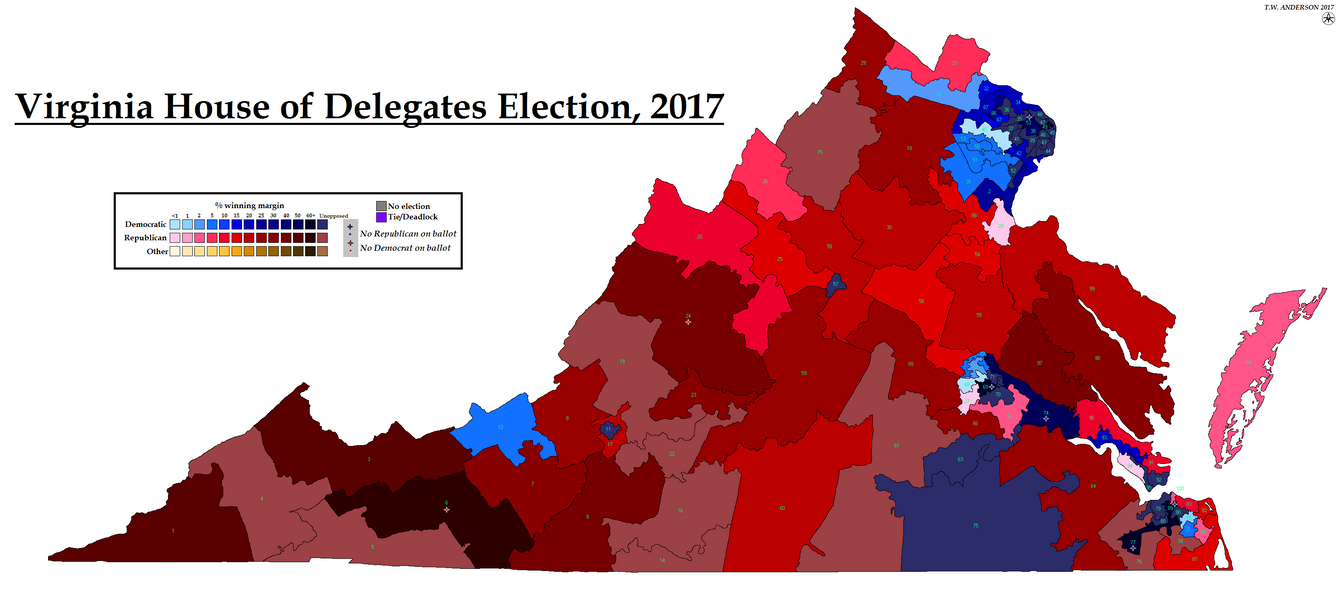
You've got several errors with the map. You have Richmond, Hopewell, Danville, Emperio, Chesapeake, and Montegomery going for Gillespie and Fluvanna, King George, Westmoreland, and Caroline going to Northam. Switch all those and you'll be good.
 

Thande

Donor
Just a note about your writeup, if all races break as they stand currently, dems will tie the chamber at 50-50, not lose 49-51. However, chances are recounts will change the end picture....
Possibly - I was trying to count them up based on what the NYT has called and comparing their uncalled races to those on the AP, but I may have miscounted.

Anyway, here is New Jersey, General Assembly and Senate. @Zaffre can you let me know if I have made any errors in my write-up, in particular I triple-checked district 2's senate result because that doesn't seem to fit the pattern at all.

edit: edited Senate link which went to the wrong year
 
Last edited:
Possibly - I was trying to count them up based on what the NYT has called and comparing their uncalled races to those on the AP, but I may have miscounted.

Anyway, here is New Jersey, General Assembly and Senate. @Zaffre can you let me know if I have made any errors in my write-up, in particular I triple-checked district 2's senate result because that doesn't seem to fit the pattern at all.

edit: edited Senate link which went to the wrong year

It looks right to me - I don't know too much about the 2nd district, but I think Brown positioned himself as pretty Anti-Christie, and Bell is both a) the appointed successor to a long-term incumbent that passed away, and b) a not especially strong candidate that ran into some issues in the primaries.
 

Thande

Donor
It looks right to me - I don't know too much about the 2nd district, but I think Brown positioned himself as pretty Anti-Christie, and Bell is both a) the appointed successor to a long-term incumbent that passed away, and b) a not especially strong candidate that ran into some issues in the primaries.
Sure, it just really sticks out when almost everything else is reasonably consistent between the two estates.

I still can't get over district 8 (assembly) as well. I wish the Democrats had taken it (I suppose they still might in a recount) just so I would have a new example of 'literally won a district they didn't contest last time'. 24 was reasonably close too.
 
Most of these aren't technically election maps as such, but meh.

The 1776 Constitution of Virginia, which nullified British rule over the Commonwealth (its preamble featured wording very similar to the later U.S. Declaration of Independence), also replaced the House of Burgesses, North America's oldest legislature, with a new bicameral General Assembly. This was made up of a House of Delegates, largely a direct successor to the Burgesses, and a Senate, which partially replaced the old, appointed Governor's Council. The bicameral structure of Virginia's new government would become a great influence on the U.S. Constitution, but it differed from the later document in one important respect: in Virginia, it was the Delegates that were apportioned in a fixed manner, with two seats for every county, and the Senate that was chosen by single-member districts. The number of senators was fixed at 24, but the Delegates grew with each additional county. In addition, cities or towns that were considered large or important enough to warrant representation could be given a seat of their own in the Delegates, but in order to prevent a Virginian version of the British rotten boroughs, a provision was added that would disenfranchise any borough whose population fell below half that of the least populous county in the Commonwealth.

va-1828.png


By 1828, the Virginia House of Delegates had 214 seats. 210 of these were elected by the Commonwealth's 105 counties, and in addition to the original designated towns of Williamsburg (the original state capital) and Norfolk, Richmond (the new state capital) and Petersburg (a growing industrial town) had been given representation in the House. The state had grown a great deal since 1776, but while a large number of counties had been added in the west, none had been merged in the east, and the Tidewater (the low-lying eastern part of the state) was massively overrepresented in both houses as a result of this. By contrast, the Piedmont (the eastern foothills of the Appalachians) and the Shenandoah Valley (in the north-central part of the state) were underrepresented by a significant amount. Resentment between the east and west of the state had been growing for some time, fuelled by the apportionment issue as well as the different economic natures of the areas (the Tidewater being rich plantation country, while the west was largely made up of yeomen farmers who were only rarely slaveholders) and, related to both, the fact that Virginia only allowed property owners to vote. With the election of Andrew Jackson to the presidency, and the rise of the new "Jacksonian democracy" under his patronage, conditions were right for a constitutional convention to work out these issues once and for all.

va-convention-1829.png


The 1829-30 Virginia Constitutional Convention has become known as the "last gathering of giants", because it featured as delegates nearly every political heavyweight in the state, from former Presidents James Madison and James Monroe to maverick Congressman John Randolph of Roanoke to Chief Justice John Marshall and future President John Tyler (lots of Johns and Jameses in Virginia at this time). Torn between the Tidewater interest and the western yeoman interest, the Convention ended up settling on a compromise constitution. The franchise would be extended somewhat, but universal suffrage for all male citizens remained some way away, and the west's demand for slaves to be discounted for representation (in order to boost their own standing) was rejected. Only one delegate from west of the Blue Ridge Mountains (the traditional dividing point between western and eastern Virginia) voted for the final document, but it nonetheless passed and went into effect in early 1830.

va-1830.png


The main innovation of the 1829-30 Convention, then, was the reform of the apportionment method for the House of Delegates. The size of the House was reduced to 134, with the possibility of increasing the number as far as 150 in the future. The counties remained the basic unit of representation, but the number of delegates per county was made flexible, and for the first time, it became possible to merge counties whose population was small enough not to warrant separate representation. In order to ensure equitable representation, the state was divided into two grand divisions (for the Senate), one east and one west of the Blue Ridge Mountains, and into four grand districts (for the Delegates), the western division being split along the ridge of the Allegheny Mountains and the eastern one into Tidewater and above-tide (Piedmont) regions. The number of seats for each division and district were fixed in the constitution, and although the constitution required a reapportionment every ten years, the distribution between the grand districts was not allowed to be changed.

Ultimately, the 1830 constitution did little to solve the growing mistrust within the state, and in 1851 a second convention would be called to make further reforms. This established universal suffrage, and made the Governor and all state-level judges directly elected positions (rather than the previous situation where the Governor was elected by the legislature and judges appointed by the Governor), but by then it was too late. When the Commonwealth of Virginia narrowly voted to secede from the Union in 1861, the western yeomen saw fit to secede from the Commonwealth of Virginia.
 

Thande

Donor
Spectacular work, Ares. Fluid party identities do make it hard to depict a meaningful election map, as you say, but it's still very interesting. (In those maps I did of the 1630s/40s English elections, it helps that you can retroactively classify almost everyone as a Royalist of Parliamentarian just as a colouring-in exercise, even if that's not strictly the lines they were elected on).
 
Spectacular work, Ares. Fluid party identities do make it hard to depict a meaningful election map, as you say, but it's still very interesting. (In those maps I did of the 1630s/40s English elections, it helps that you can retroactively classify almost everyone as a Royalist of Parliamentarian just as a colouring-in exercise, even if that's not strictly the lines they were elected on).

I can do that with all the Congressmen and other national notables who served on the convention, but most of the members were either state legislators or judges, and for them it gets rather harder.

Of course, the only party system that even existed in the US at this point was a vague division between people who liked Andrew Jackson and disliked John Quincy Adams and people who were vice versa, and ultimately that's not that important of a distinction to this convention - it was mostly about west vs. east, and to a lesser extent the suffrage question.
 
The obvious follow-up to the above: the secession convention.

va-convention-1861.png


This met in Richmond from February to December 1861, and voted on secession twice. The first time, on April 4, it voted resoundingly against secession. But that wasn't the end of the matter, as a large proportion (about half) of Virginia's Unionists were "Conditional" Unionists who needed assurances from the federal government on issues including slavery and military levies before resolving definitively not to secede. So the convention voted to send a delegation to Washington to consult with the newly-inaugurated President Lincoln, and hopefully receive such assurances from him. Lincoln was initially sympathetic, and had previously had his allies in Congress draft a constitutional amendment protecting slavery in those states where it already existed (the so-called Corwin Amendment). But when the South Carolina militia opened fire on Fort Sumter on April 12, the mood in Washington changed. Jefferson Davis, the President of the newly-formed Confederate States of America, had called for 100,000 volunteers to defend against any invasion from the North, and Lincoln soon responded in kind, calling for 75,000 volunteers to protect federal property in the newly-seceded states. To the dismay of Virginia's Conditional Unionists, this included state quotas, and Virginia was to contribute 3,500 men to the defense of the Union.

On April 17, a second vote on secession was taken, and this time, only the Unconditional Unionists voted against, producing almost a two-thirds majority for secession. The votes against secession came almost exclusively from the Ohio and Shenandoah valleys, and resistance to secession would continue in these areas, culminating with the counter-secession of the former and parts of the latter as the state of West Virginia in 1863.

(A note on the map itself - the "No/Yes" votes aren't explained by my source, but I would guess they're No votes that switched to Yes)
 

Thande

Donor
More excellent work. I hadn't realised until recently there was so much information available about the southern legislatures' secession votes.
 
More excellent work. I hadn't realised until recently there was so much information available about the southern legislatures' secession votes.

This is a convention, not the legislature, but yes. ISTR I've previously mapped the Texas secession vote, which was an actual referendum.
 

Thande

Donor
This is a convention, not the legislature, but yes. ISTR I've previously mapped the Texas secession vote, which was an actual referendum.
Yeah, as you say, it was a mix of popular referendums, legislature votes and conventions. IIRC there is an excellent but confusing map from the 19th century which tries to represent all of them at once.
 
2012.png

2012 is done! Differences from 2014:
  • More Democratic areas; especially in Maine and Iowa
  • Less anemic Minnesota Democrats
  • Alabama is less noticeably uncontested
  • An uncontested Kansas district sticks out like NE-03 in 2016
  • Dark red converges into northeastern Texas
  • Also, the first county boundary change; an independent city in VA that was disestablished between 2012 and 2014
 

Thande

Donor
2012.png

2012 is done! Differences from 2014:
  • More Democratic areas; especially in Maine and Iowa
  • Less anemic Minnesota Democrats
  • Alabama is less noticeably uncontested
  • An uncontested Kansas district sticks out like NE-03 in 2016
  • Dark red converges into northeastern Texas
  • Also, the first county boundary change; an independent city in VA that was disestablished between 2012 and 2014
Nice work. What does the striping on those Louisianab parishes mean?
 
This one's big, and to be honest fairly dull, so I'm linking it as a thumbnail rather than show the whole thing.

Virginia's elections under the 1850 census were dull by the standards of the time, but nonetheless sort of show the political evolution of the state in the years leading up to secession.

To begin with, while there was a uniform date for presidential elections by 1850, uniform dates for elections to Congress were still several decades away. Each state set its own schedule, the majority ignoring Election Day entirely, and since Congressional sessions normally did not open until the first week of December, multiple states held their elections in odd-numbered years. Virginia was one of these, and normally held its elections on the fourth Thursday in May.

The 33rd Congress (1853) was a relatively dull affair. The Whig Party was starting to come apart at the seams after fierce internal disputes over the Compromise of 1850, and as a result, the Democrats swept to power with a two-thirds majority in the House of Representatives. In Virginia, this resulted in the loss of both the party's two held seats. Virginia had always been a fairly safe Democratic state, but in 1853 it became extraordinarily so.

In 1855, however, the Democrats lost nearly half of their seats. This was mainly due to the Kansas-Nebraska Act, Senator Stephen Douglas' proposed panacea for the slavery question, which turned out to be even more inflammatory and divisive than the Compromise of 1850. The newly-founded Republican Party, based around the old Free Soil movement led by Charles Sumner and Joshua Giddings alongside disaffected Northern Whigs such as William Seward and Abraham Lincoln, began its inexorable march forward by taking 34 seats in this election, but all of them were in northern states. The more successful opposition movement, which won 51 seats and came within an inch of eclipsing the Whigs, was the "American Party", or as it became known to its opponents and eventually history, the Know-Nothings, who promised to completely ignore the slavery issue in favor of letting the entire nation unite to kick the shit out of the Irish. Their candidate, Beverly-based lawyer John S. Carlile, would win election to Virginia's 11th district, but otherwise the map was unchanged.

1857 saw something of a return to the status quo, possibly aided by the popularity of Appalachian golden boy James Buchanan in the state. It probably also helped that the Know-Nothings were seriously on the skids, losing all but 14 of their seats and leaving the Republicans as the only significant opposition force.

1859 was where the cracks began to show in earnest. Turns out electing someone on the sole basis that, having spent the last several years abroad, he didn't have a known opinion on the one issue that dominated all others and threatened to tear the nation apart unless resolved to everyone's satisfaction, was not a recipe for long-term stability, and Buchanan's administration was making enemies faster than one would think possible. A shooting war had broken out in Kansas over whether or not slavery should be allowed in the territory, and both sides of the debate formed their own shadow governments to prepare for statehood and frame their own constitutions. In September of 1857, a pro-slavery convention in Lecompton wrote a state constitution for Kansas, and sent it to Washington for ratification before even putting it to a vote among the people of Kansas itself. Buchanan endorsed the Lecompton constitution before Congress, despite even his own staunchly pro-slavery territorial governor denouncing it, and this kicked up a shitstorm that would split the Democratic Party. The result was a Republican victory, bolstered by the split between "Lecompton" and "Anti-Lecompton" Democrats. In Virginia, a staunchly pro-Lecompton state, four of the incumbents (at least one of them anti-Lecompton - I can't really find much detail) were defeated by "Independent Democratic" candidates, in addition to which Opposition (ex-Whig) candidate Alexander Boteler won election in the 8th district.

As we've seen, by the time the 1861 elections would've been held, Virginia had seceded from the Union. Nonetheless, Unconditional Unionists arranged elections for five of the state's thirteen districts in October of 1861, all of which were won by "Unionist" candidates. The Senate had already seated two Unionist senators in July, but nonetheless there was a dispute in the House on whether or not the five Virginian representatives should be seated. William G. Brown of the 10th district, Jacob Blair of the 11th and Kellian Whaley of the 12th were seated at once, as was Charles Upton of the 7th, but in February of 1862, Upton was expelled from the House. The three remaining Virginians were joined in May by Joseph Segar, who was declared entitled to represent the 1st district (this was at the height of the Peninsula Campaign, when it seemed probable that eastern Virginia would soon fall), and Upton was eventually replaced by Lewis McKenzie. By the time of the 1863 elections, West Virginia had been admitted and given three of Virginia's seats, and the remainder of the state would not elect representatives to Congress until July 1869.

va-congress-1850.png
 
Last edited:
Top