Map Thread XVIII

Status
Not open for further replies.
Crosspost from the current MOTF:
~The Empire of the Britons~
241qdex.png

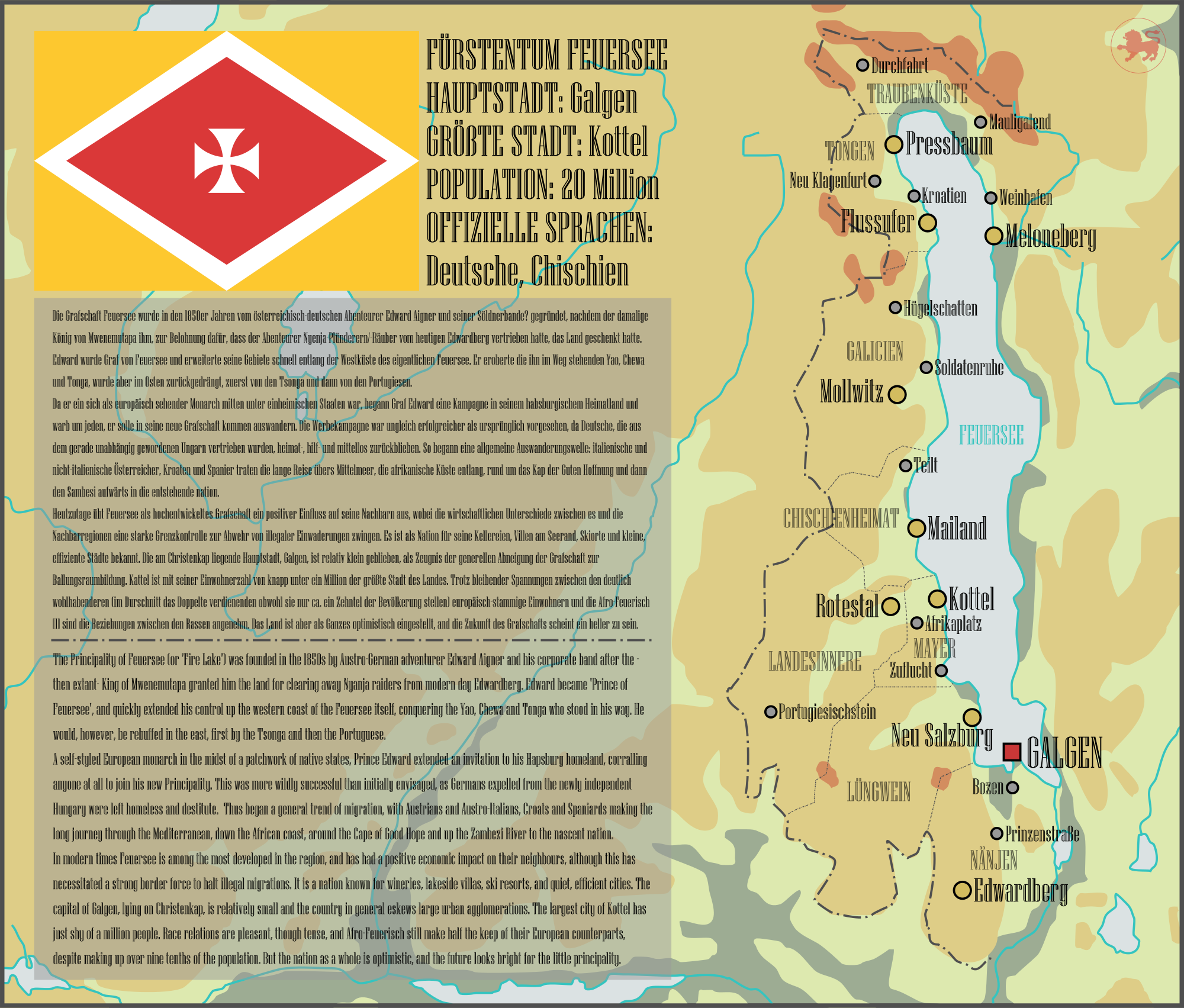
The backstory is pretty much all on the map, if you would like more detail then check out my timeline. Credit to deviantart user Gouchecevalier for the CoA.

 
Last edited:
A map detailing the Principality of Feuersee, a Euro-African kingdom founded by an Austrian adventurer, or 'pulling a Sarawak' as I like to call it. 'Tis a part of my Shanti Shanti Shanti project (which is actually more comprehensive then you'd first think, I just haven't posted it).
This map was initially made as a challenge by my partner to see how quickly I could make a map; it took about thirty minutes. The text and lore took significantly longer, of course. To that effect, special thanks to @KanonenKartoffel and @SaveAtlacamani, who did most of the translating and advised me to the German that was mine. Couldn't have done it without you.

dcxd328-94cc1b86-d972-4795-8072-95d0368e2f76.png

Hold on hold on, your partner is into alt hiat cartography? Smack a ring on him/her/them.
 

Isaac Beach

Banned
Very cool. Is this real life Malawi or somewhere else?

Thanks a bunch. It is indeed Lake Malawi. Malawi means “flames” in the Chichewa language, which is why I called it Feuersee; ‘Fire Lake’ in German.

Hold on hold on, your partner is into alt hiat cartography? Smack a ring on him/her/them.

Just mine, aha. We’ve had long conversations about all sorts of historical topics: he knows far more than he has any right to about Maria-Theresa, Prague and Tasmanian history. I fully intend to, unless we were just flirting these past three years.
 
Mercy for Austria
Here are some maps, based on what would happen if Germany got broken up like Austria Hungary and Austria Hungary got land taken away like Germany.
After WW1
anotherversailles.png

Austrian Extent in 1939
av1939.png

Austrian Extent in 1943
advance1943.jpg

The fall of the Austrian Axis
advance1946.jpg

Also, here's a preview of another map series I'm working on.
twcw.jpg
 
These are the next two maps. They are a scenario where the Axis signs peace with the Allies and Russia, and Russia also becomes a liberal republic.
WW2- Stalemate
The World in 1960.
twcw.jpg

The World in 2018
tcw2.jpg
 
A map detailing the Principality of Feuersee, a Euro-African kingdom founded by an Austrian adventurer, or 'pulling a Sarawak' as I like to call it. 'Tis a part of my Shanti Shanti Shanti project (which is actually more comprehensive then you'd first think, I just haven't posted it).
This map was initially made as a challenge by my partner to see how quickly I could make a map; it took about thirty minutes. The text and lore took significantly longer, of course. To that effect, special thanks to @KanonenKartoffel and @SaveAtlacamani, who did most of the translating and advised me to the German that was mine. Couldn't have done it without you.

dcxd328-94cc1b86-d972-4795-8072-95d0368e2f76.png
I was wondering what the ethnic cmposition of the country would look like...
 

Isaac Beach

Banned
I was wondering what the ethnic cmposition of the country would look like...

Overwhelmingly African, mostly Chichewa and Yao, as well as Tongas, Tumbuka and a few Tsonga. The Nyanja were unfortunately cleansed from the area, and cast further afield into the Congo. There are also a number of Baganda representing the business interests of the Kingdom of Buganda, a very large number of which are Jewish. Europeans make up a little over 2 million people, mostly Germans but there are communities of Spaniards, Croats, Italians and Czechs each numbering over 100,000 people and noteworthy minorities of German Jews, Portuguese and Greeks. There's a number of Indians, Arabs and Persians running about as well. Between these groups are a large number of 'coloureds', which are steadily increasing in number and make up about a million people nationwide.
Geographically, the state is actually pretty thoroughly mixed. The 'whitest' regions of the country are in Nänjen and Lüngwein, as well as the cities of Kottel and Meloneberg where they form slim majorities. The main reason the south is so white is because the Nyanja were pushed off the land and the white settlers basically subsumed their place. The central strip of the nation around Kottel is mostly Chichewa and Tumbuka. Though majority Tonga, the region of Tongen is also the primary home to the nation's large Croatian community. Everyone else can be founded pretty much across the entire nation to various degrees, though the ethnic minorities are concentrated in the cities, especially the Jews.
 
Actually quite realistic as Adolf Hitler was originally Austrian!

He was also a staunch believer in pan-Germanism, which is why he joined the German army and lived in Bavaria, so I sincerely doubt he'd return to Austria and set himself up there.

The concept itself is interesting, and the map is fun, but I wouldn't call it 'realistic' in those terms.
 
A map detailing the Principality of Feuersee, a Euro-African kingdom founded by an Austrian adventurer, or 'pulling a Sarawak' as I like to call it. 'Tis a part of my Shanti Shanti Shanti project (which is actually more comprehensive then you'd first think, I just haven't posted it).
This map was initially made as a challenge by my partner to see how quickly I could make a map; it took about thirty minutes. The text and lore took significantly longer, of course. To that effect, special thanks to @KanonenKartoffel and @SaveAtlacamani, who did most of the translating and advised me to the German that was mine. Couldn't have done it without you.

dcxd328-94cc1b86-d972-4795-8072-95d0368e2f76.png

Very interesting premise.

'Pulling a Sarawak' - well now that it's been said, it's a meme, so get on it map-makers. Who else from where else could have pulled a Sarawak, and where else on Earth was vulnerable to such adventures?
 
Top
Status
Not open for further replies.
Top