...why is the capital of that purple midwestern state in Oshkosh, Wisconsin of all places?
You are using an out of date browser. It may not display this or other websites correctly.
You should upgrade or use an alternative browser.
You should upgrade or use an alternative browser.
Map Thread XVII
- Thread starter Upvoteanthology
- Start date
- Status
- Not open for further replies.
Yeah yeah, I know it isn´tWell admittedly, this isn't Harry Turtledove levels of Parallelism, but then I'm a sucker for Anglo-Dutch empires and the Songhai and of Berber South America - so hell yeah!

And to be honest, Songhai America isn´t exactly my idea (https://quantumbranching.deviantart.com/art/Songhai-Empire-469576409). But Berber pirates of the Caribbean could be
Alex Richards
Donor
Just a Greater Denmark idea that was in my head. Would be open to color and Danish criticism/suggestions.
Northern Border of Sleswig should probably be the pre-WWI border.
Have you considered including Danish India?
Deleted member 105545
Holy crap what is going on here?
That's USSR seem to be really overstretching itself.
Did the Soviets pull Manchurian candidate on the US, or was there a WW3?
What was the exact year of this?
Checkout the thread "Soviet Victory".
Deleted member 105545
lol that does look like the capital. But no, they declared independence from USSA, in a protest of a lack of infrastructure in that area. They got readmitted into the union, but refused to become part of wisconsin....why is the capital of that purple midwestern state in Oshkosh, Wisconsin of all places?
Coolness.
Um, what's Swedish for "can we have a key to this map, please"?
Skallagrim
Banned
God, it's always so shocking how different the world looks when you just flip on an axis, makes everything look so much more bent and twisted then it actually is.
To some extent, this is the projection. North America in particular is warped quite a bit, being so near the 'edge'. But because it's where we expect it, we recognise its shape(s) and our brains correct for the distortion. When it's flipped around and in another place, our brains don't correct the distortion, and we see how warped it really is.
Pretty weird idea, but it's not that it looks much more bent and twisted then it actually is, when flipped. It's that when not flipped, it seems less bent and twisted then it actually is!
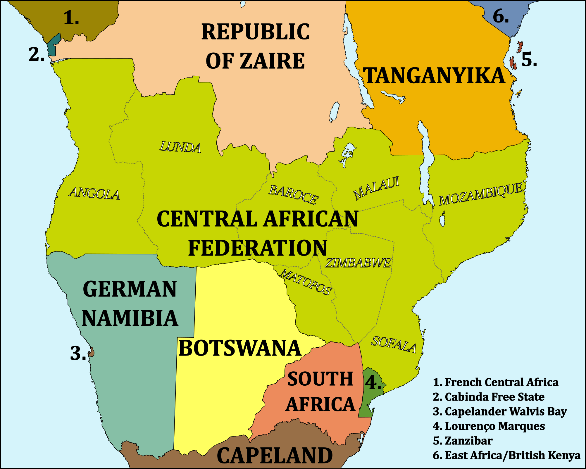
After the era of imperialism began to come to a close the Portuguese government in Lisbon had to deal with a rising desire for independence in their Central African colonies of Angola, Mozambique, and Zambezi. The three colonies were connected with a handful of rail lines and several major rivers, so the pro-independence leaders in the colonies shared similar ideals and especially the mines in Zambezi were dependent on Mozambique in order to export their minerals. So after intense negotiations between pro-independence groups and Lisbon an arrangement was made where the oil-rich protectorate of Cabinda and the very south of Mozambique, including the colonial capital of Lourenço Marques, which was home to the biggest white population of Portugal's continental colonies, were to remain in Portuguese hands, and the remaining colonies were to achieve independence as a federation in 1962. In order to appease regional aspirations each of the three colonies were divided into two regions, thus leading to the eight regions now making up Central Africa.
Within the next ten years both Cabinda and Lourenço Marques also achieved independence from Portugal, with the former being taken over by Libertarian mercenaries, and the latter achieved independence with the support of the white regime in South Africa.
Last edited:
Skallagrim
Banned
snip
Ooooooh, independent Cabinda, independent Zanzibar and independent Lourenço Marques. Interesting!
(Of course, the bizzarre notion of calling South Africa "Azania" - I know it's an OTL idea - always triggers me. It's historically inaccurate. Ancient Azania was in East Africa!)
ST15RM
Banned
Coolness.
Um, what's Swedish for "can we have a key to this map, please"?
Hej, Analytical Engine. Det kommer snart att finnas en kortnyckel, jag börjar redan en.
Hej, Analytical Engine. Det kommer snart att finnas en kortnyckel, jag börjar redan en.
*uses Google translate*
Thanks.
Ooooooh, independent Cabinda, independent Zanzibar and independent Lourenço Marques. Interesting!
(Of course, the bizzarre notion of calling South Africa "Azania" - I know it's an OTL idea - always triggers me. It's historically inaccurate. Ancient Azania was in East Africa!)
You know what: I'm changing it
It was a rather spontaneous decision (and the name is a bit too recent in terms of when it was considered), so... It's now Capeland. Boring, but descriptive (also: suck it, Orange Free State!).
Old map, i made it in august for a duel in ResPublica
and also i won it :^)
The Great Game's gone south for Russia. :3
fashbasher
Banned
God, it's always so shocking how different the world looks when you just flip on an axis, makes everything look so much more bent and twisted then it actually is.
And also that Greenland becomes the world's bearskin rug when you flip it.
The Great Game's gone south for Russia. :3
Looks more like north to me...
Zimmerwald1915
Banned
Not south enough! Russia still shares a border with India, the security of which shall not be secured until Britain rules everything from Samarkand to the gates of Petrograd.The Great Game's gone south for Russia. :3
Not south enough! Russia still shares a border with India, the security of which shall not be secured until Britain rules everything from Samarkand to the gates of Petrograd.
And also to Petropavlovsk.
Not south enough! Russia still shares a border with India, the security of which shall not be secured until Britain rules everything from Samarkand to the gates of Petrograd.
Talk about your mission creep.
Talk about your mission creep.
The border must be secured!
- Status
- Not open for further replies.
Share: