Map Thread XV

Status
Not open for further replies.
Cross-posting my (just in time!) MotF entry.

"Leave Means Leave!"

On the morning of Friday 24 June 2016, Europe awoke to shocking, confusing and distressing news coming out of the United Kingdom. Rumours had been circling around the Internet and media outlets overnight that Brexit was happening and that the British people had chosen to leave. Then, nothing. Just as an official announcement to proclaim the results was expected, all communications from the UK suddenly stopped. People close to the British coast and living near the intra-Irish border reported a blindingly bright light and then complete darkness. As dawn broke it became clear that the British had truly left - all houses, factories, farms and roads had disappeared and been replaced with miles of unbroken woodland, and Low-lying areas which had been drained and reclaimed from the sea generations ago were now inundated. In fact, the only humans to remain where those who were those who were immigrants to Britain, foreign tourists and military personnel.

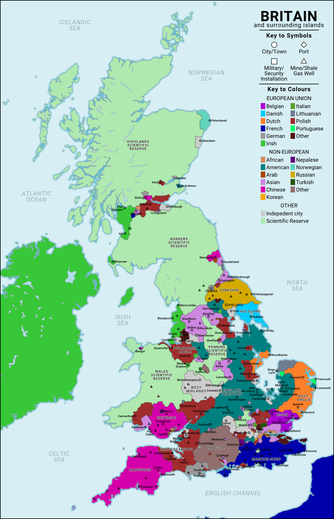
The strange and unsettling events of that fateful day are now a century past and Britain is now a fractured land. Britain's European neighbours' initial interests in the island were to secure their own maritime frontiers through a series of installations along the North Sea and Channel coasts. These have since grown into significant settlement areas with many of the "New Britons" speaking French, Dutch or Flemish as their first language. Further inland, the United States, China and Russia compete to extract the replenished natural resources, with the first's pre-existing military bases having provided them with an early advantage, although the Chinese, and now the Russians have caught up fast. Between these European "colonies" and superpower mining outposts lie the polities established by those who were left by the Event, the most numerous of whom are the Poles and various Asian communities (Indians, Pakistanis and Bangladeshis). Of note is the refugee-established nation of Zanggal on the south coast and the numerous multicultural independent cities. Of course, the one thing all these polities have in common is their quasi-legal status: shortly after the Event, the UN declared the territory of the United Kingdom to be an international scientific reserve and prohibited any nation from claiming land or establishing a permanent population on the islands, thus giving them a similar status to that of Antarctica. This declaration had very little practical effect however, and is now regarded as little more than a trivial curiosity. In fact most New Britons give it as little thought as they do to whatever happened to those than voted to leave 100 years ago.

brexisot_by_rubberduck3y6-db9z6vv.png
 
Here's the first map I made on Inkscape. I'd like to thank Upvoteanthology for suggesting me to use this program. Here's a link to the map because it's too big to upload here.

Scenario: After the Independence of The United States of America in 1783, it sparked revolutions through out North and South America. Nations such as Mexico, California, and New Brunswick gained independence at this time, being inspired by the American Revolution. By 1800, all mainland colonies and some Caribbean islands gained independence from their European masters. Relations between these nations are good, though, there are talks between the US and Louisiana about selling the northern part of Louisiana to the Americans as apart of them future expansion...

Also, when I submitted it to my deviantart page, I found that it the white became the same color as the background for whatever reason.
 
Yes, plus all buildings and infrastructure in the UK (with the exception of any buildings being lived in by non-Brits).

I'm also wondering where they ended up, if anywhere.

That also means that there is no power, gas, water, etc. for those left behind, as well as little food. Post-ISOT UK would suck for those left behind.
 
Quibble: It's actually a very common misconception that the fens around the Isle of Ely and other parts of eastern England were completely underwater. Before 1630 (when serious attempts at drainage began), there were a small number of permanent lakes, but most of the area labelled as the fens (e.g., this map) were actually swampland, dry enough to walk on in summer, but typically flooded enough that fishing could be done in the area most winters. The flooding made the land effectively unusable even for agriculture (due to the high risk of an early flood ruining a crop), but it was never simply a large area of open water.
 
Last edited:
I'm also wondering where they ended up, if anywhere.

That also means that there is no power, gas, water, etc. for those left behind, as well as little food. Post-ISOT UK would suck for those left behind.
Nah. Nearly every search and rescue helicopter in Europe would be fishing people out.
 
Here's the first map I made on Inkscape. I'd like to thank Upvoteanthology for suggesting me to use this program. Here's a link to the map because it's too big to upload here.

Scenario: After the Independence of The United States of America in 1783, it sparked revolutions through out North and South America. Nations such as Mexico, California, and New Brunswick gained independence at this time, being inspired by the American Revolution. By 1800, all mainland colonies and some Caribbean islands gained independence from their European masters. Relations between these nations are good, though, there are talks between the US and Louisiana about selling the northern part of Louisiana to the Americans as apart of them future expansion...

Also, when I submitted it to my deviantart page, I found that it the white became the same color as the background for whatever reason.
I like the rough, c18th-style cartography!

The background ended up transparent because you haven't got anything there. Although it looks like there's a white background in Inkscape, it's actually transparent so you need to remember to add a layer with a white rectangle below your drawing. You can also post your map directly here by copying its URL and putting it between {img} {/img} tags (with square brackets instead of curly ones).
 
Last edited:
Quibble: It's actually a very common misconception that the fens around the Isle of Ely and other parts of eastern England were completely underwater. Before 1630 (when serious attempts at drainage began), there were a small number of permanent lakes, but most of the area labelled as the fens (e.g., this map) were actually swampland, dry enough to walk on in summer, but typically flooded enough that fishing could be done in the area most winters. The flooding made the land effectively unusable even for agriculture (due to the high risk of an early flood ruining a crop), but it was never simply a large area of open water.
Thank you. The maps I could find were all a bit ambiguous about whether those areas were open sea or simply swampland.

Still not fun though. Especially for those in need of medical attention/treatment.
I imaged a large-scale international aid operation to provide the basics immediately after the ISOT.
 
The background ended up transparent because you haven't got anything there. Although it looks like there's a white background in Inkscape, it's actually transparent so you need to remember to add a layer with a white rectangle below your drawing. You can also post your map directly here by copying its URL and putting it between tags.

I fixed it. Here
 
Thank you. The maps I could find were all a bit ambiguous about whether those areas were open sea or simply swampland.

I would say there are loads or reeds, clay, and muck. And it reminds me a bit of this map. https://medium.com/matter/louisiana-loses-its-boot-b55b3bd52d1e

Are there no seperately labeled settlements for Pakistani, Bangladeshi, and Indians because they were mostly naturalized or came generations ago, or did their new immigrants join Midlands, London, and other places? And given the placement of Lincoln, I guess the Americans were iffy on what to do about it and are just waiting incase the Poles every decide to not use such a finely named settlement.
 
METACOMET'S WAR

The English plantations in AMERICA are in crisis as the year 1676 draws to a close. Across the continent, tensions with the INDIANS have reached unseen heights. Rumors fly that they are inspired by METACOMET and his war in the north, and seek to reclaim the lands they had ceded to the English. Colonists far from the centers of power abandon their farms and villages for the shelter of walled towns near the coast. They fear for their scalps and their lives. Leaders from Charles Town to New Haven write desperately to authorities begging assistance from the King’s forces. VIRGINIA is swallowed by CIVIL WAR. The spectre of HUNGER hangs over thousands as abandoned fields rot and refugees crowd together in town untouched by conflict.

Metacomet, the demonic red genius, forged an alliance with the IROKOYA to unite the Indians of New England. Through 1675 and 1676, the armed Indians overwhelmed the militias of His Majesty’s people. These places will forever sound infamy to the English ear: BLOODY BROOK, HARTFORD, and PLYMOUTH. Only a hasty defense organized by GOVERNOR JOHN LEVERETT could save the town of BOSTON from joining that list. Even now NEW HAVEN lay under siege.

And yet, against the terrified descriptions of the resolve of the red forces, Metacomet’s army hangs together by a thread. Old antagonisms simmer among Narragansett, Wampanoag, Nipmuck, and Mohawk. STRANGERS from the West -- those in fealty to the Irokoya -- strain the alliance’s resources. To the far north, war seems imminent with the FRENCH and their Indian allies, so Irokoya warriors are leaving the field to defend their homes. Metacom worries that the English may counterattack at any time.

Fear of the Indians fuels the continuing war in Virginia. Nathaniel BACON and his rebels have burned JAMESTOWN and killed GOVERNOR BERKELEY. Bacon’s army controls much of the colony, and he claims to be its new leader. The Virginia elite is divided. The Indian war in the north has convinced many of the danger from the Red Men, so they have joined Bacon’s rebels. With them come more guns and angry farmers. Men range the frontier burning Indian villages. Some of the local tribes consider asking the Irokoya for an intervention.

Across the sea, His Majesty CHARLES II views the chaos with dismay. He weighs his options. With each passing day, military intervention appears less a possibility and more a necessity.

The year 1677 draws near.

KingPhilipOneOff.png
 
Last edited:
Cross-posting my (just in time!) MotF entry.


brexisot_by_rubberduck3y6-db9z6vv.png
I'm surprised that such a) valuable and b) strategic territory would simply be left to the whims of a dozen different countries. I would definitely have either expected a) a UN dictate setting it up for English resettlement, b) UN dictate setting it up into regions of control, or c) EU claim to the territory, and subsequent division between nearby European states. Antarctica was a little different, considering it was a barren wasteland. England isn't exactly lacking in natural resources or livable area, and any disorganized land grab would almost certainly end in a world war
 
Top
Status
Not open for further replies.
Top