The Most Royal Province of the Mountain, the Seashore and the Marshes
Well, here's my very first Inkscape map (this doesn´t make it any better)
So the POD is in 1366, with a different agreement between Pedro I and the Black Prince.
With a strongest English support, the forces of Pedro of Castile are able to finally win the war. However, Castile had to cede Guipúzcoa and parts to Álava to Navarre, and Biscay to England. From there, and with some help from butterflies, England is able to roughly win the 100 Years War (actually it lasted 97 years), although it would collapse half a century later.
Meanwhile, in Spain, things weren't quiet either. Granada was finally conquered in 1398, and two years later Portugal and Castile united under the House of Ivrea (notice the shitty alt-Spanish I developed). Aragon suffered a series of civil wars, resulting with the Noble Republic of Catalonia, the wealthy kingdom of Mallorca and Rosellón, and a rump kingdom of Aragon and Valencia (which would be integrated in *Spain at the end of the XVth century.
Brazil (America) meanwhile, was discovered by basque fishermen in 1438. Fortunately, European conquest was rather better for natives than OTL's, with some amerindian states surviving into XVIIIth century (a lot of spanish protectorates in Central Brazil, two prosperous independent indian federations in the great Lake's area and two or three more on the Plains. On the Andes, we can find the isolationist Realm of Tawantinsuyu (think in a mountainous China, but less wealthy and with tobacco instead of opium problems).
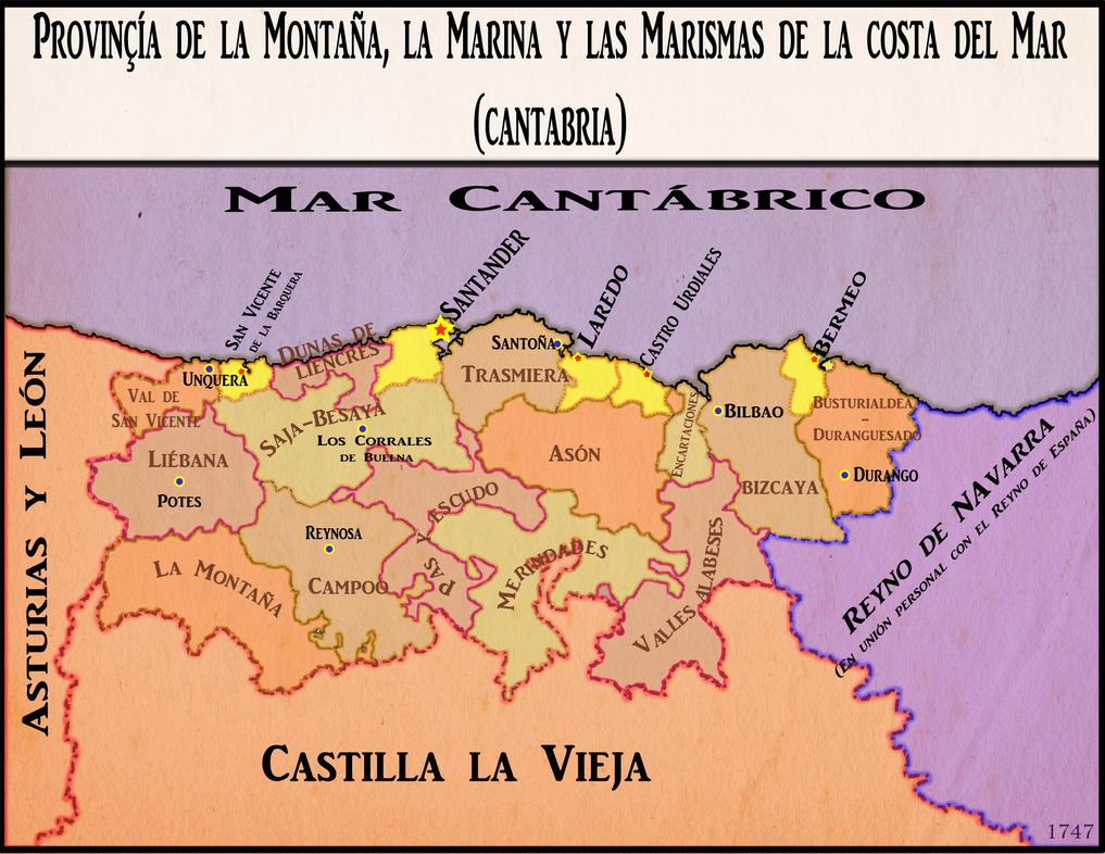
Finally, we can zoom into the focus of this map: The Most Royal Province of the Mountain, the Seashore and the Marshes (aka Cantabria, think in a
http://es.wikipedia.org/wiki/Hermandad_de_las_Marismas on steroids). Created in 1296 as a Hansa-like economic association of various cantabrian and basque ports (Santander, Laredo, Castro Urdiales, Bermeo, Guetaria, San Sebastián, Fuenterrabía,Vitoria and San Vicente de la Barquera), it grew in importance in the Castilian Civil War when (as a result of the POD), they were promised a series of privileges in exchange of helping the king Pedro. When the war was finally won, the easternmost passed to navarrese and english hands as a result of the accords, while still being part of the association. At the end of the XVth century, during the English Wars (1488-1497), Biscay was occupied by Spain and reintegrated in the realm. Navarre remained whole and despite the fact that it grew closer and finally entered in a personal union with Spain in 1588, its coastal towns finally left the association with their western cousins.
Meanwhile, as a mean to reassure the royal control over the exportation of textile manufactures and castilian wool and the goods that were being brought from North Brazil (the Southern ones came through Seville and Cadiz, and the antilleans goods through Lisbon), the spanish kings gradually created a royal (read: not local nobility governed) and loyal administration upon these five ports and the surrounding territories. As the riches kept arriving, some wealthy merchants and captains agreed to the creation of "The Royal Atlantic Bank", located in Santander. It finally grew to be one of the biggest banks in Europe, on pair with burgundians, balearics or north italian ones.
However, many things have changed since 1296. It's 1747 and though the old "Hermandad de las Marismas" is long gone, the cantabrian ports still thrive with money and trade. Still, some international conflicts are in the air and threatening commerce. The newly United Brazilian Communes might have get its independence peacefully, but some hartlinger revolts in Lombardy are scaring the european governments... Who knows what tomorrow will depart?
Anyway, here is the map with the Province of the Mountain, the Seashore and the Marshes depicted.
-Regular "mancomunidades" are labeled brown
-Urban mancomunidades (the original ports) are painted in yellow, with the towns or cities marked with a star (Santander being the capital and central headquarter of the RAB).
-Other important towns or cities marked with blue dots.
Enjoy!! Feedback and criticism welcomed!! English version here:
http://imgur.com/kiytkGn
")