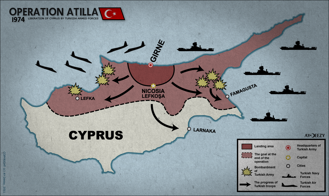
Woo! United California! But the little Mexican border territories should be morphed in Arizona and Texas.chris456 said:can you guys make this possible?
You are using an out of date browser. It may not display this or other websites correctly.
You should upgrade or use an alternative browser.
You should upgrade or use an alternative browser.
Map Thread VII
- Thread starter Ian the Admin
- Start date
- Status
- Not open for further replies.
i gotta say, that straight border in OTL iran for russia looks rather silly, though
Actually it follows the agreed lines of the spheres of influence between Russia and Britain in Iran (although in the map Britain gets more than just it's sphere in Iranian Baluchistan and gets all of Iran minus the Russian sphere).
i wanted to put the ottoman empire in there too but it would just look silly to me
yeah, i had the ottoman empire at first when i was making my own ATL, but later figured "nah, thats too implausible" and replaced it with the arab leaguei wanted to put the ottoman empire in there too but it would just look silly to me
Alex Richards
Donor
can you guys make this possible?
Well, Mexico needs a PoD in the 1840s, and Gran Colombia even earlier, possibly 1810s (that also helps with French trans-Pyrenees), but the borders in Africa are essentially those set in the 1880s. They really need changing, potentially drastically.
AlbinoPolarBear
Banned
Lol...the ultimate wet dream of a depressed Turk...
*chants in a childish mocking fashion*
nah nah! nah nah!
No EU for U! no EU for U!
It doesn't look too implausible, except for France rusing northern Spain.
Are you KIDDING? Look at... uh... uh...
...actually, you're right, it really isn't all that implausible. Though independent Galicia is a bit odd.
Nietzsche
Banned
It doesn't look too implausible, except for France rusing northern Spain.
Well, you have Spain delve into some unspeakably stupid idea, and you could probably see Catalonia attached to France instead of Spain. Maybe Spain...again, having a retard-moment, goes to war with France over the whole "Hohenzollern on the Spanish Throne" deal?
can you guys make this possible?
What happened to Bolivia and the 'Guays?
REQUEST- a Stronger Incan Empire
Can I make a request? Just got this month's National Geographic - the lead story is the rise of Incan Empire. Can someone please make a map in ATL of an Incan Empire rising a century earlier - around 1300s, thus becoming a true South American continental empire that can take on the Spaniards in the 1520s?
If by the 1523 in OTL, they could essentially control all of South America's western coast, then with some extra time, they would spread to the Amazon River basin and beyond. Thanks in advance!
This is a map of North America from a TL that I am planning on writing, until I can find a plausible way to make it happen.
Blue=USA
Gray= CSA
Light Brown= Republic of Texas
all else the same. and the colors of the nations match the color of their military uniforms.
Those borders within OTL Oklahoma are horribly anachronistic in a TL where the CSA wins independence.
They could have very well defeated Pizarro and his men, if only they weren't in a civil war.Can I make a request? Just got this month's National Geographic - the lead story is the rise of Incan Empire. Can someone please make a map in ATL of an Incan Empire rising a century earlier - around 1300s, thus becoming a true South American continental empire that can take on the Spaniards in the 1520s?
If by the 1523 in OTL, they could essentially control all of South America's western coast, then with some extra time, they would spread to the Amazon River basin and beyond. Thanks in advance!
New map showing the countries where the former colonial languages have official status. Featuring Chinese colonialism, a successful German 1848 revolution, German in Santa Catarina (Brazil), a failed Belgian revolution, a stronger Afrikaaner resistance against the British, a stronger Russian influence in Alaska, Israel also having Yiddish and Russian as official languages, more dominant Welsh and Irish, a Danish Norway as well as Danish Gold Coast and Andaman islands and a Russian colony in Sagallo.
I absolutely LOVE that concept and map
")
Goldstein
Banned
New map showing the countries where the former colonial languages have official status. Featuring Chinese colonialism, a successful German 1848 revolution, German in Santa Catarina (Brazil), a failed Belgian revolution, a stronger Afrikaaner resistance against the British, a stronger Russian influence in Alaska, Israel also having Yiddish and Russian as official languages, more dominant Welsh and Irish, a Danish Norway as well as Danish Gold Coast and Andaman islands and a Russian colony in Sagallo.
Nice one. Allow me a couple of questions:
If the Southern Chinese languages and Tibetan enjoy a good shape in China, why it's not the case with Uyghur in Xinjiang or with Mongolian in Inner Mongolia?
Kazakhstan appears as independent, yet fully Russian-speaking. How so? What about the Tatars, do their language survive?
Catalan ejoys a good shape in Catalonia, but not in Valencia nor the Balearic Islands. How so?
Last edited:
Rogue Shadows
Banned
A (roughly) accurate map of interesting stars within about 80-100 ly of Sol. Most positions are off (in fact the only star that's in exactly the right place is Sol, and that only because it's supposed to be shown with Sol front and center), but it should be more than accurate enough for, say, a mapgame.
"Interesting" is, in this case, defined as "appears in the "Star Trek: Star Charts" book that I bought a few years ago.

"Interesting" is, in this case, defined as "appears in the "Star Trek: Star Charts" book that I bought a few years ago.
Last edited:
Those borders within OTL Oklahoma are horribly anachronistic in a TL where the CSA wins independence.
They were developed afterwards by Texas as payment for Indian help in achieving independence.
Alex Richards
Donor
so there where some Wars here and there...
so can you guys figure out who that were part of the entertente and the central powers?
Wait. Russia Annexes German East Prussia, but not Polish Posen, and Britain gains German Cameroon but loses Ghana to Denmark?
Tallest Skil
Banned
so there where some Wars here and there...
so can you guys figure out who that were part of the entertente and the central powers?
Hooray for American Galicia!
That's about the weirdest thing I've seen on here.
- Status
- Not open for further replies.
Share: