A Map Shitpost Thread

Do people want a WIP thread?

  • Yes

    Votes: 62 75.6%
  • No

    Votes: 20 24.4%

  • Total voters
    82
  • Poll closed .
The Cover art for Cars 2 had a very... odd globe in the background. A couple of islands are merged to look like cars, and Greenland terminates in a straight line. One could just argue it's an alternate universe, but It still looks pretty bad regardless.

MV5BMTUzNTc3MTU3M15BMl5BanBnXkFtZTcwMzIxNTc3NA@@._V1_UY1200_CR90,0,630,1200_AL_.jpg


Stop discriminating against Ireland, Cars 2
 
The Cover art for Cars 2 had a very... odd globe in the background. A couple of islands are merged to look like cars, and Greenland terminates in a straight line. One could just argue it's an alternate universe, but It still looks pretty bad regardless.

MV5BMTUzNTc3MTU3M15BMl5BanBnXkFtZTcwMzIxNTc3NA@@._V1_UY1200_CR90,0,630,1200_AL_.jpg


Stop discriminating against Tireland, Cars 2

ftfy
 
I suppose that with fewer islands, it's easier for the cars to drive to places. Do boats exist in the Cars world? Are boats people too?
And the geography must give this world a very interesting history. For one thing, the islands that look exactly like cars might have been seen as a sign from the gods of cars' importance, and for another thing, if Ireland is part of Great Britain, that dramatically changes the cultural patterns of the region. And for a third thing, with that giant Iceland and the big truck covering Newfoundland, it must have been much easier to sail between northern Europe an North America. They could stop for supplies every couple hundred miles.
 
WW3 map.png
This is the worst imaginable map of a theoretical WW3. There are 3 wars going on. The yellow/green war in Africa, the purple/orange war in South America, and the worldwide red/blue war. Note that Scotland is independent and North America is united.
 
I made this for fun.
AHHHHHHHHHHHHHHHHHHHHHHHHHHHHHHHHHHHHHHHHHHHHHHHHHHHHHHHHHHHHHHHHHHHHHHHHHHHHHHHHHHHHHHHHHHHHHHHHHHHHHHHHHHHHHHHHHHHHHHHHHHHHHHHHHHHHHHHHHHHHHHHHHHHHHHHHHHHHHHHHHHHHHHHHHHHHHHHHHHHHHHHHHHHHHHHHHHHHHHHHHHHHHHHHHHHHHHHHHHHHHHHHHHHHHHHHHHHHHHHHHHHHHHHHH
 
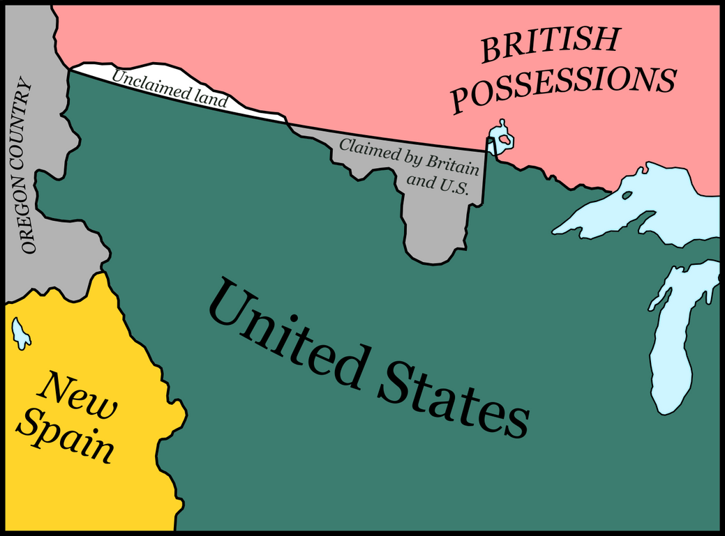
Here's something I made. This is basically a Bir Tawil situation in early 19th century North America. Britain and the US have no claims on the region known as No Man's Land because they wish to claim the more valuable Red River region. Some Europeans and Native tribes have tried to set up a nation there, but never had the ability to do so. It remains unclaimed to this day.
no_man_s_land_by_theplainsman-dbkbur5.png
That land is significantly more habitable than Bir Tawil. I understand if one government hasn't unified it, but do independent settlements exist there?
 
Here's something I made. This is basically a Bir Tawil situation in early 19th century North America. Britain and the US have no claims on the region known as No Man's Land because they wish to claim the more valuable Red River region. Some Europeans and Native tribes have tried to set up a nation there, but never had the ability to do so. It remains unclaimed to this day.
no_man_s_land_by_theplainsman-dbkbur5.png
A bit difficult for the US to make a claim, as it was based pretty much solely on the earlier French claims for the whole Mississippi basin, despite the French having only ever seen the smallest portion of it. Seems likely the U.S. would decide to just claim up to the Lake of the Forests, with the added bonus of including most of the 'unclaimed' area as well. Back then that land was claimed by the Hudson Bay Company anyways, though it might make no difference to the British. How is recognition handled here? Is the land occupied by the U.S.,while maps almost always show it as being British, as they do with the Sudan situation? I also feel that in a situation like this the Red River areas are going to have plenty of Lakotah, Dakota, Metis, so-on and so-forth there. Something with an independent Manitoba around would be interesting... Still, there is a rather narrow window of opportunity for this, with the U.S. having settled its border with Spain (and the Soanish dealing with both Anglophinic countries to decide on the southern border of the Pacific Northwest) and Mexico going independent within less than a decade (I think).
 
Here's something I made. This is basically a Bir Tawil situation in early 19th century North America. Britain and the US have no claims on the region known as No Man's Land because they wish to claim the more valuable Red River region. Some Europeans and Native tribes have tried to set up a nation there, but never had the ability to do so. It remains unclaimed to this day.
But that's good....
 
But that's good....
And now I have the amusing thought of Oregon, the Red River Valley, and that unclaimed area all become three seperate states the British (and maaaaybe Canadians) and Americans barely tolerate, while also keeping it so that the shared Anglo-American border is no longer than directly after independence.
 
Top