Sure, let's go with that, that's a plausible story.Attempting to balance the karma from you previous map, Gryph?
Sure, let's go with that, that's a plausible story.Attempting to balance the karma from you previous map, Gryph?
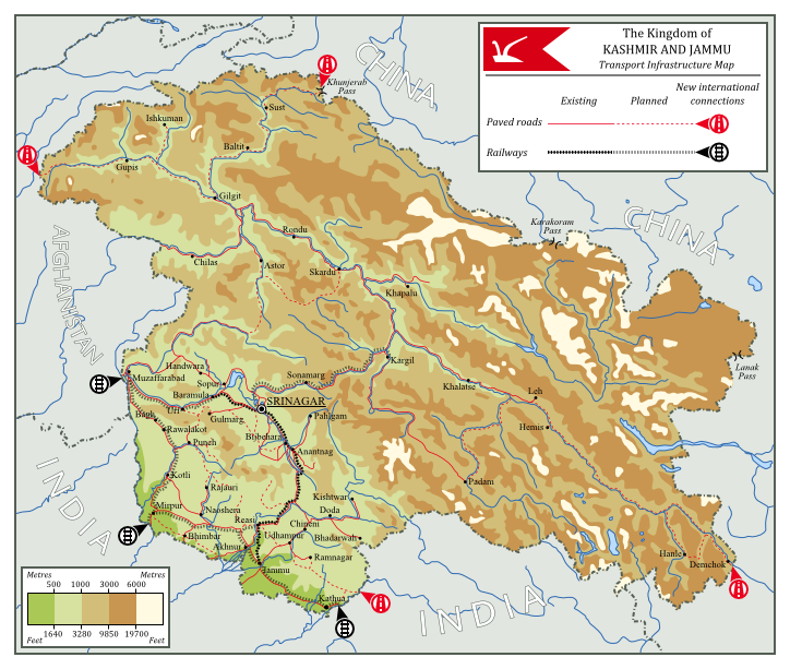
And the map:
The decolonisation of India was a complex and chaotic affair - perhaps appropriately, considering the region had the size, population, and diversity (religious, ethnic, and political) of a continent. Though the simplistic "Two-Nation Theory" - by which India was considered to consist of two nations; one Hindu, one Muslim - was popular among Muslim Indians for a time, such an easy solution quickly proved to be impractical. The rise of groups such as the Pashtun Khudai Khidmatgar in the Northwest Frontier Province brought the theory's popularity to an end, as the KK and the various Muslim movements it inspired believed India was a multitude of nations based on ethnicity, rather than a pair based on religion. Though the All-India Muslim League, which believed strongly in the Two-Nation Theory, attempted to gain power by promising support for the British during WWII in return for recognition of the League as representing all Indian Muslims, this ploy failed due to their lack of support from large portions of the Muslim population and the impracticality of their ideal independent "Pakstan".
The question of what to do with India's numerous, nominally sovereign Princely States was perhaps one of the simpler ones that faced British administrators. It was decided that they would have the option of joining a newly united India on their own terms once a united India had been established or remaining independent. It was the latter that the Maharajadhiraj of Kashmir and Jammu - Hari Singh - chose for his country. Rather than join with India, he hoped that his nation could remain neutral and independent; an Asian Switzerland nestled in the mountains of the Himalayas, prosperous and respected yet without affiliation or fear of war.
In order to attain such a status, Kashmir and Jammu was kept isolated - a hard thing to do in the midst of a Cold War, and stuck between the opposing juggernauts of India and China. Kashmir had almost no transport links to other countries, and international trade with Afghanistan and India was deliberately avoided in fear of drawing China's wrath (though Kashmir's approval of China's entry to the UN and the subsequent peaceful negotiations over disputed territory in Aksai Chin curtailed such fears somewhat). Relations between Kashmir and its neighbours was generally warm, but very limited, as it refused almost all political and economic association.
However, Kashmir's isolation helped preserve the state as a peaceful yet underdeveloped country during times when those around it underwent chaos and strife. Afghanistan, looking to throw its weight around after joining with the US, aided Turkic Muslim rebels in the USSR and China. India remained generally unaligned - save for its antagonistic relationship with China, with whom they had numerous border disputes, and numerous border skirmishes as a result - and later suffered as unrest among its Sikh population snowballed into a civil war, leaving India fractured, with a rump federation having lost much of its territory. Though political unrest in these newly independent countries would eventually begin India's reunification, Kashmir was glad to have been spared the chaos.
As the 21st century loomed ahead, the regional situation had been stable for quite a while, and without fear of invasion the people of Kashmir and Jammu were free to agitate for domestic reforms. The Kingdom gradually changed, with more and more power being devolved to democratic bodies, and franchise being extended across ethnicies, gender, class, and religious groups. The now modernised government of Kashmir now sought to modernise the country's economy. Being on generally good terms with its neighbours Kashmir was able to quickly expand their trading relationships with them, and by 2000 plans had been put in place to expand Kashmir's transport infrastructure and make several new international connections both by road and by rail.
Most of the population was concentrated in the south of the country, whereas the mountainous north was sparsely inhabited, therefore much of the development was concentrated in the south, being centred around the capital city of Srinagar. The short, simple railway line that ran though the capital was to be extended, covering a great deal of the densely populated south, connecting to Indian and Afghanistani rail networks, and providing the basis for further expansion with a line through the mountains to Kargil in Kashmir's hard to access northern areas. Roads were also to be expanded - or often just properly paved - providing ease of movement all throughout the country, as well as connecting to China along the Sênggê river in the East, and through the Khunjerab Pass in the north.
With its improving infrastructure and decreasing isolation Kashmir is on the verge of a great change, though the modern democratic government still maintains the country's now-traditional neutrality, entrenching the country's reputation as the Switzerland of Asia.
Link to DeviantArt page.
(map)
Hah. I love it. I was driving through downtown Annapolis by the State House and with all the Maryland flags that had lined the street for a moment I had thought I had been transported into a Royalist Maryland.
Though I think Carroll county would have been butterflied in this scenario?
)It's a little more than that; Vandalia and Transylvania, for instance, probably require a pre-Proclamation of 1763 POD.Is that simply "no Louisiana Purchase"? It makes sense that all those tribes would still be there when there was no place to Remove them too.
Thanks.Some formidable map-making going on lately! Excellent work from Gryphon, Krall, and PlatoonSgt - alas, as usual it makes me wish to see more of their worlds.
Please Live Suggestions
Does anyone have a place where I can get historical maps of North America? I don't want just the US, I want ALL of North America
Well, my next map is actually one of all of North America in the same world as that map, so you will be seeing more of it.Some formidable map-making going on lately! Excellent work from Gryphon, Krall, and PlatoonSgt - alas, as usual it makes me wish to see more of their worlds.
Yes, New York did, but I don't really think that would be doable. Really, Ontario is kind of pushing it, but the request was specifically for that, so there you go. The Confederated States are made up of Pennsylvania, New Jersey, Delaware, OTL Ohio and Michigan minus the Upper Peninsula (naturally not their OTL shapes, but you get the idea), plus a bit of Indiana and Illinois. Capital is in Philadelphia, naturally, and they're big on industry and agriculture and considered snobby even by New Yorker standards. Like New York is always at odds with New England, the Confederated States are always at odds with Virginia. And yes, I thought it would be funny to have a Confederacy that has nothing to do with the OTL Confederacy. Thought it was about time to remind people a confederacy isn't a bad form of government in and of itself, just used by some very bad people in history.PlatoonSgt, didn't New York try to push it's claims west to Michigan? And what states and lands make up the Confederated States? (Amusing, BTW, to have a Confederated states including none of the Confederacy.
It's a little more than that; Vandalia and Transylvania, for instance, probably require a pre-Proclamation of 1763 POD.
Generally, the whole map is a mix-and-match of borders, names, and ideas from fifty-odd years of the topsy-turviest parts of colonial and early American history; it's terribly anachronistic in many respects.
Henry Morgenthau Jr. is commonly recognized as one of the men who were the most influential with shaping post-WW2 Europe. His idea of dividing Germany into two separate nations based on a north-south axis interested the leaders of the Western nations that fought against Hitler's horde of Nazism. After much negotiation the important players among the Western Allies, as well as the local small states, had decided the post-war borders for the country, which, in their mind, brought misery not once but twice to the European continent: North and South Germany were born, with North Germany being perpetually neutralized, while the South was integrated into the young European Community. Italy too was punished, but not as severely as the Germans, with only independence-minded Sicily gaining freedom from Rome, as well as the colonial empire being taken away from Italian control.
Thanks to a powerful Western offensive, joint British-American troops met with their Soviet counterparts at Berlin, relatively close to the modern German-Polish border at the Oder River. Another faithful meeting happened in the central plains of Bohemia, where the Western troops reached Prague just three days after the Red Army had already liberated the city. These two meetings between soldiers of different ideologies then marked the rough line around which the Iron Curtain would go, a division of east and west...
In East Asia Japan was finally defeated in late 1945, after the US dropped two atom bombs on the Japanese cities of Hiroshima and Kokura, followed by Soviets forces landing on the northern island of Hokkaido. These two attacks broke the government in Tokyo and resulted in an unconditional surrender.
Post-war four regions experienced massive changes: British India was partitioned into three large states (Industan, Bharat and Madras), China saw a bloody civil war (resulting in a narrow Nationalist victory thanks to the Soviets dropping any support for the Chinese Communist leader Mao), the Dutch East Indies also saw a civil war between nationalist and communist forces (though there the Communism prevailed) and North Africa saw the rise of the United Arab Republic, first formed by the union between Egypt and Sudan (but later expanding into Libya and Palestine). Starting in the 1960s decolonization came into full swing, resulting in many "third world"-nations and ideological struggles. However the "dark continent" of Africa gave birth to some success stories: the Union of West African States, the Somali Republic and the United Provinces of Kenya being the most well-known examples.
Now the 1970s are coming to an end and the Soviet-American rivalry continues... Will the world survive the upcoming decade or will nuclear war annihilate it? Who can tell?
Hmm, nice map you got there of an alt-Cold War. I have a few questions, if you don't mind?
-I get the north-south split for Germany, but did that include Austria for the latter in the OTL negotiations, or was it an on-the-fly/TTL decision to bunch them together? Not that it doesn't make sense, just curious about the circumstances.
-In Netherlands and Belgium's cases, how well would you say integration of the locals into those countries would have gone by now? I know Morgenthau's proposed treatment of the Germans would've been less than humane, would that include large population displacements to make those borders work, or are said locals cooperating with the plan?
-Is Bohemia a "landing zone" for any dissidents trying to hop the "Czech Wall", or is one of the Germanys still the main location for such a phenomenon?
-I noticed not one, but two Commie countries in Latin America, and somehow neither one are Cuba! What's the story there? I'm betting, given Chile's status, that Operation Condor either doesn't happen or doesn't get US support.
Beautiful map Krall.
I second that, Krall. You did a fantastic job: the colors, the labels, the symbology. It's awesome.
Some formidable map-making going on lately! Excellent work from Gryphon, Krall, and PlatoonSgt - alas, as usual it makes me wish to see more of their worlds.
One comment I'll make (just constructive criticism--if you don't care for constructive criticism on this map at this time, please feel free to ignore me): the road and railway lines are a bit hard to see (especially the road lines). I don't know exactly how you'd improve that; perhaps enlarging the width of the lines would do the job. But still, that's my only issue with the map. I really do think that the rest of it is awesome. Thanks for sharing it!
Krall, you said Afghanistan was a US ally in your scenario? How did that happen?
But what he said originally was correct.Dear Iserlohn:
"...China saw a bloody civil war (resulting in a narrow Nationalist victory thanks to the Soviets not dropping any support for the Chinese Communist leader Mao)..."
Grammar Nazi is here and you can't escape my watch!