You are using an out of date browser. It may not display this or other websites correctly.
You should upgrade or use an alternative browser.
You should upgrade or use an alternative browser.
Map Thread XII
- Thread starter Baconheimer
- Start date
- Status
- Not open for further replies.
Mind-bending, Alternate History Geek!
In a burst of sleep-destroying energy (my lord, am I tired) I did a cover of Ephraim's map!!!
It'd be interesting to see how party systems would work in such a US. Methinks something like OTL Canada, but with less similar names for federal and state parties.
Ephraim Ben Raphael
Banned
Mind-bending, Alternate History Geek!
In a burst of sleep-destroying energy (my lord, am I tired) I did a cover of Ephraim's map!!!
Very nice, I heartily approve. It even has the correct name for Georgia.

Mind-bending, Alternate History Geek!
In a burst of sleep-destroying energy (my lord, am I tired) I did a cover of Ephraim's map!!!
Minor nitpicks: in #10, it says "Pennsylvannia" instead of "Pennsylvania", and in the Overseas Possessions box, "Possessions" is misspelled "Posessions".
You would think the Pennsylvanians would have grabbed that spike shooting into them in exchange for the land they gave Virginia. And I like how the Pennsylvanians only have that tiny coast on the Great Lakes. Would think they would try keeping at least one of the Three Counties on the Delaware, though.Mind-bending, Alternate History Geek!
In a burst of sleep-destroying energy (my lord, am I tired) I did a cover of Ephraim's map!!!
Witch0Winter
Banned
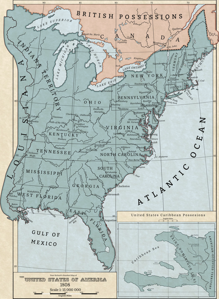
A little map I made for an upcoming TLIAD. Basic idea is that Philadelphia remains the capital of the United States (and, in the present day, the nation's largest city) while the country itself ends up more pro-British after it declares war on France in the late 1790s under Alexander Hamilton. The French Republic here ends up collapsing and the US ends up with both Louisiana and Saint-Dominigue, the latter which it turns into a territory to exploit the islands plantations and as a dumping ground for free people of color. This not only firmly establishes a stronger relation with Great Britain, but also gives the United States a nice little starting point for their history of conquest.
Anyway, I tried some new things with the map which ended up taking way longer than I thought, so I hope it turned out okay. Full size version here.
Anyway, I tried some new things with the map which ended up taking way longer than I thought, so I hope it turned out okay.
Full size version here.
Last edited:
Deleted member 67076
Nice map.
But wait, why the hell would the US annex Haiti? That area had 1/5 of the population of the US at the time. Their proportion in the House of Representatives would be insane should they be made a state.
As well, wouldn't the government be wary of adding all those free blacks? (And if they're enslaved or remain a territory for too long, that's a recipe for decades of revolt)
Witch0Winter
Banned
Ah, sorry, forgot to mention that. The US annexes Saint-Dominigue more as a territory like we did IOTL to the Philippines rather than an actual state. Especially since, under the US constitution, the island wouldn't have enough white people to be a state anyway. Basically, the US picks it up as a dumping ground for their own free blacks and for the plantations still on the island.Nice map.
But wait, why the hell would the US annex Haiti? That area had 1/5 of the population of the US at the time. Their proportion in the House of Representatives would be insane should they be made a state.
As well, wouldn't the government be wary of adding all those free blacks? (And if they're enslaved or remain a territory for too long, that's a recipe for decades of revolt)
Nice map.
But wait, why the hell would the US annex Haiti? That area had 1/5 of the population of the US at the time. Their proportion in the House of Representatives would be insane should they be made a state.
As well, wouldn't the government be wary of adding all those free blacks? (And if they're enslaved or remain a territory for too long, that's a recipe for decades of revolt)
I agree with Sov. This early, it seems the more wise decisions for the young US would be to make Haiti a puppet, and then, after they've grown, annex the island nation.
Witch0Winter
Banned
*clunk*
Sorry, that was the sound of my jaw hitting the ground.
Thank you both, that means a lot coming from you two.Seriously good-looking map, PlatoonSgt.
Like I said in the above post, I should have mentioned that Haiti is more of a territory like the OTL Philippines were, used for its plantations and as a dumping ground for free blacks, especially later on when the colonization movement picks up. Pretty much a puppet in all but name, as they're never really considered to be applicable for statehood, at least at the time.I agree with Sov. This early, it seems the more wise decisions for the young US would be to make Haiti a puppet, and then, after they've grown, annex the island nation.
Ephraim Ben Raphael
Banned
A little map I made for an upcoming TLIAD. Basic idea is that Philadelphia remains the capital of the United States (and, in the present day, the nation's largest city) while the country itself ends up more pro-British after it declares war on France in the late 1790s under Alexander Hamilton. The French Republic here ends up collapsing and the US ends up with both Louisiana and Saint-Dominigue, the latter which it turns into a territory to exploit the islands plantations and as a dumping ground for free people of color. This not only firmly establishes a stronger relation with Great Britain, but also gives the United States a nice little starting point for their history of conquest.
Anyway, I tried some new things with the map which ended up taking way longer than I thought, so I hope it turned out okay.
What happened to the rest of Louisiana? Also what program did you use to make that amazing map?
Witch0Winter
Banned
Oh, the rest of Louisiana is still there, but it's just unorganized territory so the map mostly focuses on the East Coast and eastern Louisiana. And I just used Inkscape and a whole lot of time.What happened to the rest of Louisiana? Also what program did you use to make that amazing map?
Ephraim Ben Raphael
Banned
Oh, the rest of Louisiana is still there, but it's just unorganized territory so the map mostly focuses on the East Coast and eastern Louisiana. And I just used Inkscape and a whole lot of time.
I've been trying to figure out Inkscape, do you know where I could find a tutorial to make a map look like that?
Witch0Winter
Banned
Basically everything I learned is in this tutorial from the excellent LSCatalina.I've been trying to figure out Inkscape, do you know where I could find a tutorial to make a map look like that?
BEHOLD!!!
The completed language map!
Nice map!
Mind-bending, Alternate History Geek!
In a burst of sleep-destroying energy (my lord, am I tired) I did a cover of Ephraim's map!!!
Very nice.
A little map I made for an upcoming TLIAD. Basic idea is that Philadelphia remains the capital of the United States (and, in the present day, the nation's largest city) while the country itself ends up more pro-British after it declares war on France in the late 1790s under Alexander Hamilton. The French Republic here ends up collapsing and the US ends up with both Louisiana and Saint-Dominigue, the latter which it turns into a territory to exploit the islands plantations and as a dumping ground for free people of color. This not only firmly establishes a stronger relation with Great Britain, but also gives the United States a nice little starting point for their history of conquest.
Anyway, I tried some new things with the map which ended up taking way longer than I thought, so I hope it turned out okay.
Excellent map. Why is Petersham, Massachusetts, labelled, though?
Witch0Winter
Banned
With Petersham, it's because the map I used as a base, a rather old map, had it on there so from what I can gather it was at least somewhat important back in the early 19th century.Excellent map. Why is Petersham, Massachusetts, labelled, though?
Tallest Skil
Banned
But wait, why the hell would the US annex Haiti? That area had 1/5 of the population of the US at the time.
That sounds wrong. Do you have a source on that?
- Status
- Not open for further replies.
Share: