You are using an out of date browser. It may not display this or other websites correctly.
You should upgrade or use an alternative browser.
You should upgrade or use an alternative browser.
Q-Bam Historical Map Thread
- Thread starter The Alternative
- Start date
-
- Tags
- historical maps q-bam
The Papal State and their vassal Marches in 1453 (The color is a bit darker than normal so you can actually see the vassal outlines.)

this map you are putting together is going to be a life saver dodolulupepe
") Thanks! May I ask for what specifically?
Thanks! May I ask for what specifically?Thanks : D@Dodolulupepe - you are a veritable hero.
im pretending im writing a story set in 1429 onwards, and the confidence you are putting done lines with is very reassuring. im more of a compositer than a drawer, and there are a couple conflicting depictions of this time period on the site as well as coastlines. so for u swoop in and make a map fresh from source materials that address both is a real relief.
Nice!im pretending im writing a story set in 1429 onwards, and the confidence you are putting done lines with is very reassuring. im more of a compositer than a drawer, and there are a couple conflicting depictions of this time period on the site as well as coastlines. so for u swoop in and make a map fresh from source materials that address both is a real relief.
Tiny Italian municipalities, counties, and such, outside of the Holy Roman Empire

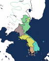
Navarre's borders, more specifically that bit that extends south of the Basque counties, looks a bit odd. What are your sources on this, if you don't mind me asking?The Crown of Aragon and her Italian possessions in 1453 (Help with Sardinian subdivisions would be appreciated!)
View attachment 614280
Castile gained that panhandle in the 1460s, it was Navarran before, my source is Ollie Bye's History of Iberia: Every Year (2020)Navarre's borders, more specifically that bit that extends south of the Basque counties, looks a bit odd. What are your sources on this, if you don't mind me asking?
I would not rely too heavily on those "history of X every year" videos, they are often inaccurate... expect for the ones by @Admiral A. Kolchak of course.Castile gained that panhandle in the 1460s, it was Navarran before, my source is Ollie Bye's History of Iberia: Every Year (2020)
For some advice, I like to cross-reference multiple sources before mapping an area. Maps from academic papers/books and up to date atlases are generally the best. (The one below is from an Italian paper on the spheres of influence in Italy during the 1450s for instance). I would slow down some so you can make sure that you are really mapping the situation accurately, especially if your references are from decades or even centuries prior/future to the date being mapped. Also when possible try to find and read information on the history of the polities for the year you are mapping.
With just a cursory glance of your recent patches, for instance, central Italy is way way off.
Here this is a map from my
Left map is all the territories de jure under the Pope, while on the Right map is the de facto situation and territory subject to the Papacy in 1455. Only the areas colored in yellow on left map are domains owned by/ fiefs which at the time were de facto subject to the Pope. Everything else was under the influence of another Italian State or otherwise "independent"... though that's not really the proper word for it.
I did a bit of collecting info and resources on Iberia and Sardinia, and I have plenty more maps from this period lying around somewhere on my computer. I will try to send what I can if I end of having time. I'd map some of it myself but I try not to intrude on other people's projects like that.
Last edited:
I didn't use History of X videos for much, actually, just a few things. For the Papal States, I've used these two maps: https://www.euratlas.net/history/europe/apenninica/apenninica_1500.html https://it.wikipedia.org/wiki/File:Repubblica_Venezia_espansione_in_Terraferma.png And on the Italian wiki for History of Venice, which was extremely detailed, showed the acquisition of some northern Papal duchies to Venice. Also, your map does show Ferrara incorrectly, it was an entirely independent duchy ruled by the d'Este, not Papal in any way. Actually, I've used the Italian Wikipedia quite a bit, since it is extremely detailed in the history of Italy.I would not rely too heavily on those "history of X every year" videos, they are often inaccurate... expect for the ones by @Admiral A. Kolchak of course.
For some advice, I like to cross-reference multiple sources before mapping an area. Maps from academic papers/books and up to date atlases are generally the best. (The one below is from an Italian paper on the spheres of influence in Italy during the 1450s for instance). I would slow down some so you can make sure that you are really mapping the situation accurately, especially if your references are from decades or even centuries prior/future to the date being mapped. Also when possible try to find and read information on the history of the polities for the year you are mapping.
With just a cursory glance of your recent patches, for instance, central Italy is way way off.
Here this is a map from myhoardcollection of the Papal States in 1455.
Left map is all the territories de jure under the Pope, while on the Right map is the de facto situation and territory subject to the Papacy in 1455. Only the areas colored in yellow on left map are domains owned by/ fiefs which at the time were de facto subject to the Pope. Everything else was under the influence of another Italian State or otherwise "independent"... though that's not really the proper word for it.
View attachment 614498
The Orsini Principality of Taranto is also slightly off but I can't seem to find my maps of it right now, apologies.
I did a bit of collecting info and resources on Iberia and Sardinia, and I have plenty more maps from this period lying around somewhere on my computer. I will try to send what I can if I end of having time. I'd map some of it myself but I try not to intrude on other people's projects like that.
Also I would love some other maps/sources, but yeah please don't make the map for me lolI would not rely too heavily on those "history of X every year" videos, they are often inaccurate... expect for the ones by @Admiral A. Kolchak of course.
For some advice, I like to cross-reference multiple sources before mapping an area. Maps from academic papers/books and up to date atlases are generally the best. (The one below is from an Italian paper on the spheres of influence in Italy during the 1450s for instance). I would slow down some so you can make sure that you are really mapping the situation accurately, especially if your references are from decades or even centuries prior/future to the date being mapped. Also when possible try to find and read information on the history of the polities for the year you are mapping.
With just a cursory glance of your recent patches, for instance, central Italy is way way off.
Here this is a map from myhoardcollection of the Papal States in 1455.
Left map is all the territories de jure under the Pope, while on the Right map is the de facto situation and territory subject to the Papacy in 1455. Only the areas colored in yellow on left map are domains owned by/ fiefs which at the time were de facto subject to the Pope. Everything else was under the influence of another Italian State or otherwise "independent"... though that's not really the proper word for it.
View attachment 614498
The Orsini Principality of Taranto is also slightly off but I can't seem to find my maps of it right now, apologies.
I did a bit of collecting info and resources on Iberia and Sardinia, and I have plenty more maps from this period lying around somewhere on my computer. I will try to send what I can if I end of having time. I'd map some of it myself but I try not to intrude on other people's projects like that.
You misunderstand the map, Ferrara was a part of the Donation of Pepin, making it de jure a subject of the Papacy, but as you said the e'Este ruled it with virtual independence, though they were in reality under Venetian and Milanese influence. As I said, everything in the map on the right not in yellow was de jure subject to the Pope, but not de facto.I didn't use History of X videos for much, actually, just a few things. For the Papal States, I've used these two maps: https://www.euratlas.net/history/europe/apenninica/apenninica_1500.html https://it.wikipedia.org/wiki/File:Repubblica_Venezia_espansione_in_Terraferma.png And on the Italian wiki for History of Venice, which was extremely detailed, showed the acquisition of some northern Papal duchies to Venice. Also, your map does show Ferrara incorrectly, it was an entirely independent duchy ruled by the d'Este, not Papal in any way. Actually, I've used the Italian Wikipedia quite a bit, since it is extremely detailed in the history of Italy.
Here's the holdings of the Apulian branch of the Orsini family in 1459 (the Princes of Taranto), its the closest I have to one of 1453.
(From I domini del principe di Taranto in età orsiniana (1399-1463). Geografie e linguaggi politici alla fine del Medioevo by Francesco Somaini)
There were many other large fiefdoms in the Kingdom of Naples at the time though.
Venice 1454-1455 (ignore the lighter shaded portions, except with reference to borders of the polities, they are "it merely shows the Venetian "sphere of influence" as seen by Venice)

Milan 1454-1455 (same principle for the lighter shades as above)

Also Castiglione della Pescaia was part of the Crown of Aragon.
Apologies for the map spam everyone.
Share: