Minus Newfoundland, yeah. And can you fix the weird upside down L border of Alberta in its northwest corner?So, all of continental North America then?
You are using an out of date browser. It may not display this or other websites correctly.
You should upgrade or use an alternative browser.
You should upgrade or use an alternative browser.
Request Maps/Flags Here
- Thread starter Tom Thumb
- Start date
- Status
- Not open for further replies.
Anyone?I have a request for someone to do. @Višeslav can do it if he's up for it, or someone else can. Can someone add Alsace and the German-speaking parts of Lorraine, Luxembourg (with the Belgian parts that got annexed in the 1800s included) and Liechtenstein? Have them be states a la Prussia, Bavaria, Austria, etc.
View attachment 473042
View attachment 472865
The internal borders for Luxembourg and Liechtenstein should be the same as they were before WW1, they're basically just annexed into Germany as-is, with the districts of Belgian Luxembourg included:
View attachment 472870
View attachment 472871
For Liechtenstein:
View attachment 472872
I would like to clarify that the Polish-Czechoslovakian border should not be the one depicted on that map, but instead the one on this map:
View attachment 472867
I'm assuming I should use these maps as reference for the internal borders?I want you...to increase the wank.
View attachment 473038
View attachment 473039
The new states shall be Aguascalientes, Belize, Chiapas, Colima, Costa Rica, El Salvador, Guanajuato, Guatemala, Honduras, Jalisco, Los Altos, Mexico, Mexico City, Michoacán, Miskito, Nicaragua, Oaxaca, Panama, Puebla, Querétaro, San Luis Potosi, Tlaxcala, and Veracruz. And give the chunks of New Mexico that were ceded from Sonora in the Gadsden Purchase back to Sonora.
Yes.I'm assuming I should use these maps as reference for the internal borders?
Wait, you forgot to make a Los Altos a state and fix Alberta's northern border.
for Los Altos's western border, should I use the Central America map, or the Mexico map?Wait, you forgot to make a Los Altos a state and fix Alberta's northern border.
I ask because the two are showing different borders.
Central America map.for Los Altos's western border, should I use the Central America map, or the Mexico map?
I ask because the two are showing different borders.
Central America map.
Last edited:
@Etruscan-enthusiast35 Would you care to give this a shot? Throw in a restored Hanover, restored Holstein, restored Electorate of Hesse, combine the two grand duchies of Mecklenburg, restore Nassau, restore Saxe-Lauenberg, restore Schleswig, combine the two principalities of Schwarzburg, combine the two principalities of Reuss, and restore the free city status of Frankfurt while you're at it.I have a request for someone to do. @Višeslav can do it if he's up for it, or someone else can. Can someone add Alsace and the German-speaking parts of Lorraine, Luxembourg (with the Belgian parts that got annexed in the 1800s included) and Liechtenstein? Have them be states a la Prussia, Bavaria, Austria, etc.
View attachment 473042
View attachment 472865
The internal borders for Luxembourg and Liechtenstein should be the same as they were before WW1, they're basically just annexed into Germany as-is, with the districts of Belgian Luxembourg included:
View attachment 472870
View attachment 472871
For Liechtenstein:
View attachment 472872
I would like to clarify that the Polish-Czechoslovakian border should not be the one depicted on that map, but instead the one on this map:
View attachment 472867
Howdy folks, here again with another flag request! I'd like to request flags for the countries of the El Facil Revolutionary Government and the Iserlohn Republic from Legend of the Galactic Heroes!
Hope this idea is interesting enough!
As far as I have seen, there are no flags for these in the show bar a plain green banner
Emblem of the EFRG military:

Emblem of the Iserlohn Republic Government Forces:
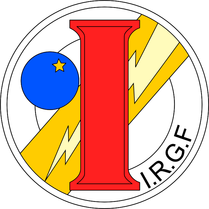
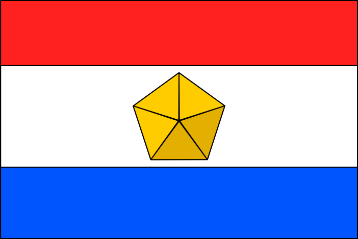
Both of these states act as a revolutionary successor government to the Free Planets Alliance, flag pictured here:
Emblem of the EFRG military:
Emblem of the Iserlohn Republic Government Forces:
Both of these states act as a revolutionary successor government to the Free Planets Alliance, flag pictured here:
Hope this idea is interesting enough!
Howdy folks, here again with another flag request! I'd like to request flags for the countries of the El Facil Revolutionary Government and the Iserlohn Republic from Legend of the Galactic Heroes!
As far as I have seen, there are no flags for these in the show bar a plain green banner
Emblem of the EFRG military:
Emblem of the Iserlohn Republic Government Forces:
Both of these states act as a revolutionary successor government to the Free Planets Alliance, flag pictured here:
Hope this idea is interesting enough!
most straightforward thing would be to replace the pentagon on the triband with the EFRG logo for the first maybe keep the red-white-blue colours for the second but in a different pattern (vertical, cross and quarters, diamond and corners, etc....)
Well, that one's easy enough.Hello. Could I please have SSR (Soviet Socialist Republic) flags for the following places:
- Poland
Venocara
Banned
Well, that one's easy enough.
View attachment 473343
Thank you for this. Do you have the others?
.png images are bitmaps (a grid of pixels), vectorial images you can find on wikipedia are .svg. There are ways to enlarge rasterised images like .png but unless it is remade from scratch, there will be loss of quality.
for example, blown up 10 time with blurriness removed, the coast line is simplified:
View attachment 472959
, actually that's pretty satisfactory. Although 10x is tecnichally larger than I wanted (though I didn't specify anyway), I have found it will be more than sufficient for my needs. So, thank you
")
Okay, here they are.Hi. I really do need help with this. If anyone would be willing to help I would be massively grateful. Thank you in advance.


Are you planning some sort of wikibox-type TL? I just ask because you've had quite a few flags made up and I don't see many connections between them.
Hey, if someone has the time to whip up a relatively simple map (and really, this does not need to be very fancy), I would just like to see a world with two large empires, one which includes...
-All of the land of the Western Roman Empire
-All of the land of the Holy Roman Empire at its height
-All of the colonial possessions ever held by Belgium, France, Portugal, and Spain, minus Chinese concessions
And the other including...
-All of the land ever held by the Byzantine Empire, except anywhere where that would overlap with the previously described empire
-The conquests of Alexander the Great
-Any of the land ever held by the Russian Empire, minus Congress Poland and the Grand Duchy of Finland
-Any land ever held by an Eastern Orthodox Christian state such as Bulgaria, Romania, or Serbia, to the extent that such land would not already be included due to having ever been part of Byzantine and/or Russian territory
-Any unfilled gaps between Alexandrian, Byzantine, and Russian land that may awkwardly stick out
Venocara
Banned
Okay, here they are.
View attachment 473402 View attachment 473403 View attachment 473404
Are you planning some sort of wikibox-type TL? I just ask because you've had quite a few flags made up and I don't see many connections between them.
I've got some timelines planned. Most flags will be used, if not immediately then later on. I've planned at least four and I'm currently writing two as we speak... all will become clear soon.
Thank you for these flags though...
Could you please put these four flags in the same place as well please...


Last edited:
- Status
- Not open for further replies.
Share: