Kavrayskiy VII projection template for Worlda. No, Worlda isn't already Kavrayskiy VII, it's a weird distortion of either Kavrayskiy VII or Robinson or something in-between.
Made a few adjustments to the edges

Kavrayskiy VII projection template for Worlda. No, Worlda isn't already Kavrayskiy VII, it's a weird distortion of either Kavrayskiy VII or Robinson or something in-between.
A map of Venus/Amtor based on ERB's series. The northern hemisphere is all my conjecture, because it remains unexplored in the series.
Excellento, nice compliment to Barsoom.
Any chance of doing Callisto from Lin Carter's series?
Probably not, I'm just making these for a wrapup to Scarlet Storm.
1st September 1939 map. It's not blank, there's colour and some internal subdivisions, but it looks easy enough to edit.anyone has good blank europe map with borders right before ww2 (after czechoslovakia getting annexed)
Does anyone have a map of south america in this style? I found this on the Wiki and can't find one of south america in the same style :/
Does anyone have a BAM for the Baltic+Eastern Europe? Thinking roughly Scandinavia, Pomerania/Brandenburg, Poland, and at least part of European Russia.
Either one big map, or two or three smaller ones:
1. the Baltic, so Scandinavia+Prussia, Pomerania, Latvia, Estonia, Finland, part of Novgorod etc.
2. a Ukraine/Black Sea Map, encompassing Ukraine, Moldovia, Eastern Bulgaria, southern Russia, and northern Anatolia.
3. a central Europe/Oder-centered blank map, covering Bohemia, Poland, Saxony, Prussia, Pomerania, northern Hungary.
https://www.alternatehistory.com/forum/threads/a-blank-map-thread.25312/page-94#post-1601323Does anyone have Europe without borders but with rivers?
Thanks, but what about requested map without the meridians and parallelles too?
Does anyone have a map of south america in this style? I found this on the Wiki and can't find one of south america in the same style :/
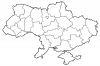
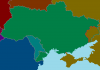
shouldn't crimea and donbass be striped? they are not russian, they are occupied territory, such territory is usually indicated by stripes of both countries.I made a maps of Ukraine. First one is adminstrative divisions before March 2014 and second one is Blank map of Ukraine in 2014-2017.
shouldn't crimea and donbass be striped? they are not russian, they are occupied territory, such territory is usually indicated by stripes of both countries.
same would also apply to transnystria, which is also russian occupied