Map Thread XV

Status
Not open for further replies.
Despite the collapse of the FPDSRAS, tension in the Balkans remained high in the lead up to the Fifth Balkan War. Macedonia and Bulgaria, in talks about possibly making minor territorial exchanged to better define the boundaries of the ethnic groups in each country. On the Second of April, Macedonia soldiers on the border with the People's Republic of the Aegean, were woken up with the sound of artillery fire from the south. At dawn, fighter craft made strafing runs on Macedonian military installations before soldiers poured over the border. In a surprise attack that took the world by surprise, Aegean forces had pushed more then thirty miles into their neighbors borders by sundown.

Not wanting the Aegean to be resurgent, Yugoslavia declared war on the Fourth of April. Bulgaria, however, in a secret agreement with the Aegean, declared war on Macedonia and Yugoslavia on the Fifth of April. By the Twelfth, all of Macedonia save it's capital at Skopje and a contingent of soldiers held up in Mt Athos. Reports of atrocities being done to ethnic Macedonians trickled out to the west.

By this point, NATO stepped in and said that all Aegean and Bulgarian forces must leave sovereign Macedonian by the Twentieth. When the deadline passed, President Gore urged NATO members to begin a campaign to defend the Macedonian people. On the Twenty-second, NATO forces began aerial sorties over Macedonia from airbases temporarily permitted to them by Yugoslavia as well as Italy. On the Twenty-fourth, Romania declared war on Bulgaria and the Aegean "in defense of self-determination and peace in the Balkans." In a quickly drawn up treaty with the United States, France and the United Kingdom, several air bases were granted to them for ten years in exchange for economic initiatives and trade deals.

In the following two months, Aegean and Bulgarian forces were forced back into their own borders. Turkey, eager to seize the Dardanelles, declared war on Bulgaria just a week before the initiation of a mass ceasefire, pressing Bulgarian out of their holdings in the area. At the same time, internal pressures and a power grab by the Yugoslav president Dragan Mikerević declared that elections that were due that August would be postponed until after any and all treaties had been signed. This led to mass protests in Croatia, Bosnia, Slovenia and Albania. By July, as the war was drawing to a close, Yugoslav forces were sent into the autonomous city of Serejevo and opened fire on protesters. This event would spark yet another bloody war that would ravage the Balkans called the Yugoslav War.

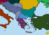
((Map is the Balkans on the First of April, 2001, the day before the Fifth Balkan War))
 

Attachments

  • Balkan Wars 02.png
    Balkan Wars 02.png
    9.5 KB · Views: 620
Let me guess. Is this a timeline in which the Inca Empire survives?

Nah, that just looks like a more unified Spanish colonial successor. I'm going to guess something happened to the American Revolution again, since the state borders are recognizably colonial, but America includes parts of Canada and not Louisiana.
 
Nah, that just looks like a more unified Spanish colonial successor. I'm going to guess something happened to the American Revolution again, since the state borders are recognizably colonial, but America includes parts of Canada and not Louisiana.
Indeed, though Spain hasn't unified quite as much internally at this point, perhaps. Looks like the Philipines might also be Peruvian here. Seems the Spaniards and Peruvians alternate between groups of island going through the Pacific, and that they jointly occupy Panama. Probably just an alliance, though a Spanish King down there would be interesting.
 
What are the X-Y axises suppose to be?

1st and 2nd principle components.

A process called PCA takes data and finds a set of new basis directions, such that each one is in a direction that captures as much variance as possible (i.e., the first principle component is the direction that out of all possible directions has the data vary the most with respect to it; the first component is subtracted as the second is found the same way, but with all motion due to the first one removed, etc).

It's used, among other things, in statistics and data analysis to reduce the dimension of high dimensional data (such as linguo-genetic data, which I think is just both linguistic and genetic data?), and help clustering.

Often, the first few principle components will capture "most" of the "information" in the data. For example, if you looked at the last several principle components, you'd find all the points were very close to each other.
 
I took an elevation map I had gotten from a GIS dump and used the clipping function in Inkscape to cut out just the part with Georgia. It's not perfect, but I think it looks nice. :)

For future reference, the Census has high resolution shapefiles for all of the states. You can use those to clip an elevation map like that in your GIS software in a more refined manner. Which GIS did you use for this one?

The Democratic People's Republic of Kentucky (DPRK):

View attachment 323234

Being a Kentucky native, the idea of my state becoming an alt-North Korea is hilarious. How'd you settle on that eastern border for !West Virginia?
 
View attachment 323245
Working on a mod project for Hearts of Iron 4, having the North America based off of TL-191 with some caveats.

First image is base year of 1928, USA along with its allies Quebec, Columbia, Suriname, and Brazil face off against the Confederacy, who controls Mexico, Central America, and most of the Caribbean.

First scenario is Fascist USA. This results in the USA partitioning the confederacy, with all the mainland regions under military rule, and Confederate Venezuela being split between Colombia and Brazil.

Second case is Democratic USA. Parts of the confederacy and split off and instead of annexed, are made into puppet states. The Confederacy remains independent, but becomes an American puppet. Texas and the Indian Territory become puppets as well.

Last case is Communist USA. Most allies except Brazil become communist states. Texas and Indian Territory become autonomous states. Most of the confederacy is annexed except for a few states. The Confederacy itself flees to Cuba as it's mainland territory becomes the Communist state of New Africa.

Final map is some of the ways the USA could be split a part depending on a civil war scenario. Theirs the Pacific States, Midwest Republic, Federal States of America, and the Republic of New England, along with Canada becoming independent.

In the final image, I'd probably leave the possibility for a Texas-dominated brand, or even a Texas-and-lands-west separate state solution. Run by a Bush-Larimore clan.

Otherwise, I quite like it. I'm curious how the New Africa state would function...
 
So Kentucky is North Korea. If the Caroline Republic is supposed to be China, it should at least be nominally communist even if it is basically capitalist nowadays...
Yeah, it should have been, but I came up with "Caroline Republic" first and fell in love with the name, so I chose to part from the analogy for the sake of creativity.

And who is the Kim family for this DPRK? Who is Kim Il Sung, Kim Jong Il and Kim Jong Un, respectively?
I came up with "Grover Barr" as an analogy for Mao Zedong, but I didn't think of who would rule the DPRK. The Sanders family, perhaps? :p

On consideration, although it's a fun scenario, it's a bit of a Jackson-wank: who did he conquer Louisiana from? And in any event he could only conquer the river mouth area, the rest of the place being a huge wilderness full of Indians (and bears). Are the Carolinans going to be able to secure both banks of the Mississippi to the great lakes before northerners [1] and Virginians moving west get to the northern bits? They'll probably grumble about the Carolinans preemptively claiming the whole middle of the country.
The Caroline Empire couldn't take control of the entire river valley. They probably allowed Mexico to have some of the western parts, while the British dealt with the neglected northern areas.

[1] "Ohioites?" The failure of the USONA [2] to maintain a political union with its westward-moving settlers is worth a mention, too.
I don't see what you mean. USONA included the whole *USA north of the Ohio and Potomac rivers.

[2] Why not USNA? We don't say "USOA." And five letters gets a bit drawn out for chanting: compare "U-S-N-A! U-S-N-A!" with "U-S-O-N-A! U-S-O-N-A!"
Another case of choosing creativity over what makes sense. I liked the idea of giving the North a proper name instead of an acronym, so I put the vowel in there so you could pronounce it as a word, like "you-SOH-nah".

Being a Kentucky native, the idea of my state becoming an alt-North Korea is hilarious. How'd you settle on that eastern border for !West Virginia?
I started out with the line of 81 degrees West on Google Earth, then I just traced along some nearby rivers and mountain ranges to make it look more natural. That's essentially how the Korean border came about.

Thank you all for asking!
 
Well this is an interesting scenario, Kentucky as North Korea... could you make a map of this TL's North America? I wanna see how the lands that are our USA in OTL turned out...
 
The Democratic People's Republic of Kentucky (DPRK):

View attachment 323234
USONA is a weird name choice, but I did so love the word Usonia as a young teen so I approve. Is Youngstown a real place, or is it named after the Mormon leader? And strange that Arlington, a plantation, would become a larger city than Alexandria, especially as they were both right next to each other. And who, exactly, knows Kentucky and Virginia as West and East Virginia? And what is the Usonian(probably a decent thing to call them) capital? New York? Someplace inland?
 
For future reference, the Census has high resolution shapefiles for all of the states. You can use those to clip an elevation map like that in your GIS software in a more refined manner. Which GIS did you use for this one?
I have QGIS but barely know how to work it. This is all done in Inkscape. :p
 
Top
Status
Not open for further replies.
Top