You are using an out of date browser. It may not display this or other websites correctly.
You should upgrade or use an alternative browser.
You should upgrade or use an alternative browser.
The Union Forever: A TL
- Thread starter Mac Gregor
- Start date
Threadmarks
View all 449 threadmarks
Reader mode
Reader mode
Recent threadmarks
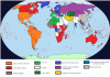
The African War: 2025 2025: Foreign and Domestic Developments 2026: Foreign and Domestic Developments Culture: Dreamworld's The Presidents (2025-2026) 2027: Foreign and Domestic Developments Culture: Asia-Pacific War Films from the Sub-continent Culture: The Old Earth Chronicles World Map 2027Has anything changed in Spain or the Balearic Islands?
Looks like status quo is holding; I bet those in the Balaeres/Canarys are becoming grumpy about being "Germany's Vacation Destination".
Mac, made a few edits on the map, centered around the CSAS. I know you were trying to show the observer status/joint membership of some, but I just cleaned up the lines in Madras/Burma/Malaya. Hopefully that is ok; they were overlapping some borders and generally uneven. I also recolored a single pixel of AAA possession in the Andaman and Nicobar Islands; just looked like a small error. I didn't see any others, but I gave it a cursory glance.
Also, if I may, might it be possible to suggest a different color for the AAA? They look like a British-aligned block, considering the similar color (Pale red right next to Red). i would suggest a different shade of gray or some other neutral color to make them stand out and to indicate that they have a closer relationship to the Technocratic Union than to the Commonwealth.
Are there any strong Technocratic movements outside of east Asia? Like how Venezuela was Corporatist during the Asia-Pacific War?
I think that you forgot Tibet and Kashmir. Weren't they belong to sphere of Russia?
I think that Georgia and Armenia might very well seek alliance with AES. In fact, it is most plausible thing.
AAA is bit odd looking when member nations are so far from each others, speciality West Africa.
When did Philippines join to LAR or is that color just descriping its close relationships with USA?
And I think that there might will be another bloc agains Persian bloc. Probably formed by Kurdistan, Syria, Arabia, Kuwait and Arab Emirates.
On Tibet and Kashmir, there position and Russia isn't really clear. Sometimes Russia acts like they are in their sphere and other times it seems they are better described as neutrals.
The phillipines are not a member of the LAR but have long had close relations with the USA.
again the map is just one possible depiction of sphere's of influence.
There has been growing talk of an Arab bloc but nothing concrete has happened yet.
Has anything changed in Spain or the Balearic Islands?
Still don't recognize each other. However signs of a thaw may be in the works.
Map looks great. How did you do it?Looks like status quo is holding; I bet those in the Balaeres/Canarys are becoming grumpy about being "Germany's Vacation Destination".
Mac, made a few edits on the map, centered around the CSAS. I know you were trying to show the observer status/joint membership of some, but I just cleaned up the lines in Madras/Burma/Malaya. Hopefully that is ok; they were overlapping some borders and generally uneven. I also recolored a single pixel of AAA possession in the Andaman and Nicobar Islands; just looked like a small error. I didn't see any others, but I gave it a cursory glance.
Also, if I may, might it be possible to suggest a different color for the AAA? They look like a British-aligned block, considering the similar color (Pale red right next to Red). i would suggest a different shade of gray or some other neutral color to make them stand out and to indicate that they have a closer relationship to the Technocratic Union than to the Commonwealth.
View attachment 311649
Are there any strong Technocratic movements outside of east Asia? Like how Venezuela was Corporatist during the Asia-Pacific War?
Good question. Technocratic movements are widespread and vary in intensity. I would say one of the strongest movements outside of Asia is in Angola.
what is the level and the objectif of the "turin pact" in the space and wil be participate in the race for Mars and the Moon ?
So far the Turin Pact's efforts in space has been concentrated on satellites and unmanned probes. They don't have any plans to enter the race to Mars but a manned orbital mission may not be to far off.
Does Angola still belong to Portugal?Good question. Technocratic movements are widespread and vary in intensity. I would say one of the strongest movements outside of Asia is in Angola.
Map looks great. How did you do it?
Let me go over the steps mentally. I used GIMP 2.8; I prefer 2.6, but I think 2.8 is the new standard. Sorry if this is a bit lengthy and tutorial-ish, but I wanted to be comprehensive.
First, I reset all of Madras, Burma, and Malaya to solid blue/red as the base. I selected blue and red using the Fuzzy Select Tool (Hotkey U) and the Select By Color Tool (Hotkey: Shift+O). By holding shift while making the selection, I was able to add the various regions together. You can remove a region from selection by holding the ctrl key. The fuzzy select tool selects all similar colors from a contiguous region (say, if you used it on the main portion of Siam, it would select the continental portion, not the isthmus below). The Select By Color Tool selects all colors on the active layer that are the same (again, if used on Siam, for example, it would select all CSAS Blue on the map). Another tool that is useful is the temperature tool (Hotkey: O). This allows you to select the color of whatever you're hovering over. Holding ctrl will allow you to set your secondary color to that color instead of primary, but I find it's sometimes easier to just select one color at a time.
I selected the red that was on Madras, for example, with the Select By Color Tool. I then selected the pencil tool (N) and changed the brush from the fuzzy brush to a solid, circular brush. (Click on the Circle underneath opacity) This ensures that anything you pencil in will be entirely solid. To cover a large region, I'd suggest a brush about 6-10 pixels in size. This can be adjusted underneath the brush selection. Then, I colored over all the red in Madras with blue. I repeated the same steps for Burma and Malaya with the colors reversed.
Then, I selected Madras with the Fuzzy Select Tool. This had to be done twice, as there is one small portion east of Hyderabad that isn't contiguous on the image. After those regions of Madras and Ceylon (I forgot whether Ceylon was independent or part of Madras, but I included it therein as it was on the original alliance map) are selected, I picked a random pixel where I wanted to start. Make sure that your Pencil tool (N) has a size of 1 for this and the solid brush (i don't think it matters, but good policy to keep it the same).
Once you have the first pixel placed, hold shift. This allows you to create a line from the previously selected point to the next. After that, hold ctrl. This allows you to fix the angle of the line to built in designations. I believe 0, 15, 30, 45, 60, 75, and 90 degrees are the default ones. Once you have both held down and a 45 degree angle achieved, click again to draw a line between your starting point and the end point. Now, as only the regions of Madras/Ceylon were selected before, they are the only regions that have the red line on them.
From there, I just moved up 4 pixels and repeated the process. (I figured a 3 pixels of base color for every 1 pixel of alternate color is good for this case). Here, you have to do it by hand (there likely is a filter I don't know about). However, they are also easy to check; whatever the distance you choose, make sure it is the same between each line. I liked to just put my cursor over a pixel in the previous line and count up 4. Even if you're not over a selected square, it's ok: you can have an imaginary starting point in non selected space and have it overlap selected space.
This is also how you can line up the lines in Burma with Madras. Once done with Madras, deselect everything (Ctrl+Shift+A is the built in deselect all option; just think of it as the anti-select all of Ctrl+A) and then use the fuzzy select tool to select all the red of Burma. Make sure that only Burma is selected. Then, with Blue selected on your pencil tool (size 1 again), click on a line in Madras that you think would also be on Burma if extended across. With that imaginary starting point set, hold shift and ctrl, extend the line to Burma, and click again when it has covered the entire area. Then repeat making the lines 4 pixels apart once more. Continue on as you did for every successive case.
-
All that said, have one correction and one suggestion. Correction was a pixel that was wrong just east of Hyderabad (which was my error on the previous part). I removed it. Secondly, here is (one) suggestion for a color for the A3. It isn't as bold as the rest of the other alliance colors, but it stands out from the neighboring 3 power blocs (most notably the Turin Pact and the Commonwealth). The only one it could be conflated with is the Orthodox Council, but they are far enough removed from one another that it should be an issue. (The Turkic League and the Turin Pact are far closer, and their colors stand out well enough).
Also... does the UK still maintain Bahrain in the Commonwealth? Saw that the pixel was there, but wasn't quite sure about whether it was the case or not.
Attachments
Does Angola still belong to Portugal?
No. Angola got independence on 1980's during Portuguese Civil War.
2007: Foreign and Domestic Developments
2007
Foreign and Domestic Developments

A Great War Centennial parade in Britain
Foreign and Domestic Developments
A Great War Centennial parade in Britain
The year 2007 marked the start of the Great War Centennial. Commemorations were held across the world, but varied significantly from country to country. In France, the anniversary was used to highlight the dangers of authoritarianism and the peaceful and prosperous century that followed the nation’s defeat. Other nations like Germany and Russia used it to tout their past and present martial prowess. More than a few commentators and authors pointed to the supposed similarities between the current tense international stage and the situation in Europe 100 years earlier.
In January, China’s Directorate of Infrastructure announced the completion of the Liu Bangguo Bridge linking the opposite sides of Jiaozhou Bay. This two tiered structured completed a high-speed rail link and automobile expressway between Tsingtao and Weifang. At 25km, it was the longest bridge over water yet constructed.
Following months of acrimonious hearings, German Chancellor Ernst Osterloh resigned as Chancellor after 17 years in office when his KVD and EKD political allies finally abandoned his Conservative led government. The crisis erupted after a cover-up regarding government mishandling of the 2003 Breslau nuclear disaster was revealed by the Viennese newspaper Das Licht. A new coalition under Helmut Koch of the German Democratic Union (DDU), along with the DKP and EKD, assumed control of the government.
The 2007 World’s Fair was held in Seoul, the capital of the Technate of Korea. Of the many devices and new technologies displayed, arguably the most remarkable was additive manufacturing or 3D printing as demonstrated by the Pusan based company Hyeogsin Industries.
After over two years in office, President Rowland announced his keystone foreign policy initiative the Pacific Treaty Organization during an address delivered from Honolulu. The PTO sought to codify an agreement between a diverse assortment of nations with large stakes in a peaceful and democratic Pacific basin including Siam, Malaya, Brunei, Sarawak, New Zealand, Australia, Indonesia, East Timor, Japan, Canada, Mexico, the Philippines, the United Kingdom, the United States, and Latin American nations bordering the Pacific. This proposed alliance cut across other longstanding power blocs including the League of American Republics, the Commonwealth of Nations, and the Community of South Asian States. Furthermore, nations which had been largely neutral, such as Japan and Indonesia, were being asked to take a public stand against the Technocratic Union. Debate on ratification continued to rage into the new year with the issue set to come to a vote in most countries by June, 2008.
Per a referendum held three years earlier, the Dominion of British Congo become an independent country inside the Commonwealth of Nations. Styled as the Republic of Katanga, the new government in Victorville under Prime Minister Rudyard Delacroix sought to strike an independent tone while remaining close to his ComNat allies from which he sought assistance fighting armed groups raiding across the border from the Congo Republic.
Flag of the Republic of Katanga
Last edited:
The Technatics seem to be causing tech to advance quickly but the question is at what cost. Why to I get the feeling they are willing to do whatever they have to do to advance tech.
I like the sounds of the PTO. A united from against teh technatics is needed.
I like the sounds of the PTO. A united from against teh technatics is needed.
Honestly IMO major wars will keep happening till someone lights the bomb in anger at least once. With this not being the rush A-bomb program of WWII OTL with more nations than OTL having nukes and most of the major players having thermonculear weapons its going to be ugly when this happens.Hrm. That basically is the every single nation east of Persia that is in Asia that is not a Technocrat state, except India and Russia. ...Which both hate China.
Yeah. Definitely feels like something is going to happen.
Threadmarks
View all 449 threadmarks
Reader mode
Reader mode
Recent threadmarks
The African War: 2025 2025: Foreign and Domestic Developments 2026: Foreign and Domestic Developments Culture: Dreamworld's The Presidents (2025-2026) 2027: Foreign and Domestic Developments Culture: Asia-Pacific War Films from the Sub-continent Culture: The Old Earth Chronicles World Map 2027
Share: