Interesting, a world where the labour movement never united into the Labour party perhaps?
The labour movement was put on hold as everyone in the country united to stop the oncoming Cornish conquest.
Interesting, a world where the labour movement never united into the Labour party perhaps?
The labour movement was put on hold as everyone in the country united to stop the oncoming Cornish conquest.
Preview, still need to add labels, notes. Thoughts, criticism?
Preview, still need to add labels, notes. Thoughts, criticism?
I don't see a #6 or #7.
Is that Roman-aligned Ostrogoths in eastern Spain?
Preview, still need to add labels, notes. Thoughts, criticism?
Well, I was stealing some ideas from an old AH scenario: the Vandals fail to make it to Africa and with the naval and economic resources still in play Rome is able to hold onto at least part of Hispania when the Visgoths come knocking, allying with the Suebi to help draw off some of the pressure. There's been a sort of re-conquista over some three centuries, with the lighter colored bits being taken in the last 50 years and still being a bit Special Circumstances (a lot of heretics, for one thing). Right now, the Romans are wondering if it was entirely a good thing that they drove the Visigoths out of Iberia, since it looks like the weakened Gothic state may be overrun by the Franks.
(Exactly how did Roman North Africa avoid getting taken by one predator or another? Vigorous hand-waving. But I will say that the western Romans moved their capital at one point to Carthage since it was where the money was, and are still there, although thinking of perhaps moving to Iberia now that it's mostly secure and a bigger source of manpower).
Pretty nice: did France start colonizing North America earlier and rather more energetically than OTL, or is all that blue fairly notional at this point?
Preview, still need to add labels, notes. Thoughts, criticism?
 Eapecially Gothic Macedonia is a nice touch. Alemanian Italy remembers me of my own Araldyana Timeline, even if I am unsure if it will make it into the newest version.
I love myself a well made map about the decline of the West!
One nitpick: I would not show Svandinavia that way. Your POD seems to be pretty recent. We have no evidence to suggest
that Sweden existed at this point. You might want to show it split between Eastern Geatland, Western Heatland and Svealand. The Smålandish hinterland might not even be under anyones control.
Since, I'm pretty sure I've never posted this here before, I've been working on and off of it for a year now and alt-words seem to be slightly popular right now, I thought it might be a good idea to show this.
So, this is my unnamed world in its 5th iteration of landforms, with its final iteration of tectonics and about 50% of the topography finalized. The west continent and the southern and eastern ends of the central continent are the 100% finalized parts. The rest is WIP.
I hope to one day finish topography then from there move on to (in order), prevailing winds, ocean water currents and potential thermohaline current, biomes, disaster zones (wind storms, hurricanes, extreme precipitation, earthquakes, volcanos) and then ecology construction with as many distribution maps as my interest can sustain. Although that's probably all another year in the future. Extremely harsh criticism and nitpicking highly desired.
Yay! Actual tectonics.
Since you wanted criticism I'll try to give a couple critiques. The first thing that stuck out was that those mountain ranges look a little too large to be an oceanic subduction thing. I'd expect them to either be thin and tall like the Andes or wide but a bit shorter like North America's western cordillera.


I also wonder a little bit about the ratio of tropical to temperate lakes. It seems like the southern continent should have a few more lakes unless they're currently at a glacial maximum (though I don't know if you're adding lakes later).
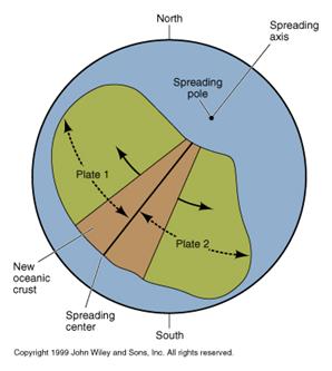
A-axis of r-rotation? I'm afraid I have no idea what you're talking about.Did you account the axis of rotation in those plates? most are small and it isn't usually a huge changer, but that larger middle plate might have some effects going on.
Other than that it's one of the better maps I've seen around here for the creation of a new world. Too many folks seem to ignore tectonics altogether.
I'm not totally certain about that wordla map. Some of those mountain ranges seem exaggerated while others seem muted. I'd try to find some other sources to check. Also if you can find paleo-historic maps they make good references (I'd say something like the Carboniferous or Devonian would be closer to your world). See here https://www2.nau.edu/rcb7/mollglobe.htmlSo, on my references layers I used both the Andes and the Western Cordillera for the mountain ranges and then Australia and Western China and Siberia for the foothills. The thing is, is that the topographical base map has pretty much every mountain range reaching up into the white which ended up with using the total height to maybe go overboard with the purple.
I get the reasoning, just trying to point out similar situations on earth that you can compare (for the impact of that southern continent I'd suggest looking at Africa and Europe for inspiration).My reasoning for how I did do them had a few parts. The first was that the Northern continent was receiving the brunt of the main thrust of the Antarctic continent and the smaller "Central American" continent was also moving in a similar direction to double up on the forces in the southeast corner where I went to town with white. The second was due to the fact that this collision area involved one of four of my planned large shallow seas. Based off of from E-W, the Arctic, Barents Sea, Hudson Bay and the Mediterranean meets Indonesia. I have no idea if this even actually helps the tectonics here.The third was that the southern continent was in closer proximity to the Antarctic continent and likely (I haven't planned the shallow seas and continental shelves perfectly yet) brushing right up against the actual shelf of the continent.
Basically just make them a bit shorter, and that should do you.Would it fix it if I cut down dramatically on the extent of primarily the purple and white in the red area on top of a bit of a rehaul on the upper ends of elevation in the blue? Or does it require more than that?
Okay, just thought I'd check. (Though that one peninsula of the eastern continent looks a little odd with so many lakes.)Waaay back when I first created the continents there were a few lakes dotted around the continents that eventually became the ones you see. So, they're ones that I wanted to have for a particular reason (I must have a fetish for big lakes near coastlines). The rest of the lakes are being added after I do biomes while creating watersheds and rivers.
A-axis of r-rotation? I'm afraid I have no idea what you're talking about.
I'm happy to help. Hope those paleo maps help.Thanks, that means a lot actually.
