WIP Map Thread

I mean, maybe I misunderstood your map, but isn't it post-apocolyptic due to nuclear war?

I could see Greenland effectively returning to being Terra Nullius.
Well it wasn't really due to nuclear war but that's on me for not having a proper explanation.
US went isolationist, russia dominated the eu and china dominated africa into submission, the two became enemies, and then some government scientist discovered a method to create near limitless resources. At which point aliens using Earth as a prison planet (hiding in the Moon) manipulated russia and china into a nuclear war. Then they tower of babel-ed the world by getting rid of all long distance communication and changing a few other things. Maybe they're using earth for entertainment too? But for some reason they let people stay around and let them sort of rebuild society. It was however alot easier in the new world. I'll stick with what I said before and say that the story is just "don't think about it"
So this is the world split into small countries after like 60 years of minor demographic change
 
1645088901271.png

Finally, Africa is finished, all 115 countries.
 
Last edited:
Can you explain to me southern Africa @erictom333 ?
  • Light yellow is Namibia, a state for the various Khoisan and other peoples. Official languages are Afrikaans and Khoekhoe.
  • North of Namibia are Hereroland, Ovamboland, Kavangoland and Caprivi (needs a new name), various states for the associated peoples.
  • In OTL Zimbabwe there's Ndebeleland in brown (with autonomy for the Kalanga), and Zimbabwe in orangeish.
  • OTL Mozambique comprises, form north to south, Makua-Lomwe, Sena, and Gaza.
  • Capeland in orange, mostly self-explanatory.
  • The various native states in eastern OTL South Africa: Tswanaland, Limpopo, Venda, Lesotho, eSwatini, KwaXhosa, and KwaZuli, plus Transvaal (light orange), a Boer state.
Limpopo is Pedi dominated, I assume? Can you explain Ethiopia and Uganda? I don't understand why you split them the way you did.
 
Limpopo is Pedi dominated, I assume?
Yes.
Can you explain Ethiopia
The Afar and Tigray-populated parts in the north have been made independent, the Somali parts in the east given to Somalia, the Nuer and Anuak parts in the west to the corresponding states, and the rest (plus the Oromo-populated parts of Kenya) forms a rump Ethiopia.
and Uganda
Split the Nilotic chiefdoms in the north (blue) from the Bantu kingdoms (orange).
 

Chapman

Donor
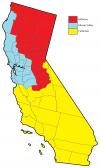
Posted this in the American politics thread too but maybe here is a better place for it? A quickly slapped together map of broken up California, mostly based on political lines (drawn from the 2020 presidential election). Thoughts?
 

Attachments

  • CA_Division_1.png
    CA_Division_1.png
    268.7 KB · Views: 180
Posted this in the American politics thread too but maybe here is a better place for it? A quickly slapped together map of broken up California, mostly based on political lines (drawn from the 2020 presidential election). Thoughts?
I'm not a huge fan of modern California partitionism anyway, but to be honest I don't get this one. You've got the Central Valley split three ways. Alpine and Mono Counties are largely cut off from easy access in your rump California by the Sierra Nevadas. Same problem with Del Norte in Jefferson, which only has roads going south along the coast and north into Oregon. The political or cultural angles don't work either (Fresno under Los Angeles? "Silicon Valley" isn't a good name for a region that large and that state's too small for both San Francisco and Sacramento).
 
Last edited:
Yes.

The Afar and Tigray-populated parts in the north have been made independent, the Somali parts in the east given to Somalia, the Nuer and Anuak parts in the west to the corresponding states, and the rest (plus the Oromo-populated parts of Kenya) forms a rump Ethiopia.

Split the Nilotic chiefdoms in the north (blue) from the Bantu kingdoms (orange).
Why wouldn't the Amhara who speak a Semitic language and use the same writing system as the similarly Semitic Tigrayans hare a state with them? For that matter, why aren't the Gumuz with the Nilotic state? Also, I don't think your Ugandan Bantu/Nilotic divide is correct.

Languages_of_Uganda.png
 

Chapman

Donor
I'm not a huge fan of modern California partitionism anyway, but to be honest I don't get this one. You've got the Central Valley split three ways. Alpine and Mono Counties are largely cut off from easy access in your rump California by the Sierra Nevadas. Same problem with Del Norte in Jefferson, which only has roads going south along the coast and north into Oregon. The political or cultural angles don't work either.
To be fair I didn't make this with the thought that it would be particularly good for anyone overall. It's more the successful scheme of Peter Thiel and a gaggle of his fellow billionaires who want to turn Silicon Valley into a tech bro paradise and figure they can gain support by roping the conservative parts of the north into their movement. As far as my partition of the state goes...again, admittedly I only looked at the 2020 election results as a gauge for what goes where. The most pro-Trump counties (minus a few, plus a few blue counties surrounded by red) make up Jefferson, while Silicon Valley takes the nearby blue areas.
I admittedly know virtually nothing about California tho so I appreciate the critiques, gives me things to reconsider.

(note: totally intended as fictional)
 
Why wouldn't the Amhara who speak a Semitic language and use the same writing system as the similarly Semitic Tigrayans hare a state with them? For that matter, why aren't the Gumuz with the Nilotic state?
Mainly religious: the mostly Muslim Afar, Tigray and Somali got their own states, but everyone else got lumped into Ethiopia.
Also, I don't think your Ugandan Bantu/Nilotic divide is correct.
Fixed.
 
Mainly religious: the mostly Muslim Afar, Tigray and Somali got their own states, but everyone else got lumped into Ethiopia.

Fixed.
The Tigray in Ethiopia are largely Christian while about half of the Oromo are Muslim. Even from a religious standpoint, the division defies logic.

Looking elsewhere at Senegal, isn't Serer of closer relation to Fula and Wolof than it is to he Manding languages?
 
Last edited:
1645372812255.png

I was having a hard time with my america map, I ran out of ideas at Wyoming and Montana. So I'm taking a break to do this. This is a world that resolved the climate crisis and walked away not learning a thing. Russia and France are technocratic, Syria restored its multiculturalism, the pink outline is the Organization for Cultural Preservation a mostly democratic (nowadays at least) socially conservative bloc that competes with the yellow outlined North Sea League (liberal but like thatcher liberal). There was a Ukrainian holocaust, lots of borders are shaped by climate change effects i.e. the Bulgarian-Romanian border or the borders of the Benelux region. Finally, the caucasus (Transcaucasia) is led by a schizophrenic russian ex-general who wants to fuse the genetics of all caucasian people together with gene editing to end the ethnic tension in the region.
 
View attachment 720584
I was having a hard time with my america map, I ran out of ideas at Wyoming and Montana. So I'm taking a break to do this. This is a world that resolved the climate crisis and walked away not learning a thing. Russia and France are technocratic, Syria restored its multiculturalism, the pink outline is the Organization for Cultural Preservation a mostly democratic (nowadays at least) socially conservative bloc that competes with the yellow outlined North Sea League (liberal but like thatcher liberal). There was a Ukrainian holocaust, lots of borders are shaped by climate change effects i.e. the Bulgarian-Romanian border or the borders of the Benelux region. Finally, the caucasus (Transcaucasia) is led by a schizophrenic russian ex-general who wants to fuse the genetics of all caucasian people together with gene editing to end the ethnic tension in the region.
1645382741986.png

Small update to Asia before I go out to the gym so erictom333 doesn't feel bad about clogging up the thread, keep it up!
 
Mockumentary.png


A cover in progress of Kevin Willmott's C.S.A.

I'm trying to balance the ignoring of butterflies like in the film with my desire not to totally ignore them and to explore the implications of what we were told in the film. (e.g. the C.S.A. having a neutrality pact with Hitler)
 
usareunitedworldaWIP.png


Current WIP for the world in an alt-hist I'm making. The POD is the US collapses when they were unable to create an effective constitution, but they reform during the great depression. Please ask questions so I can flesh out the lore more.
 
Top