Can't wait for ChileOh boy - time for the post-glacial fractal that is Canada. Good luck with that.
You are using an out of date browser. It may not display this or other websites correctly.
You should upgrade or use an alternative browser.
You should upgrade or use an alternative browser.
The R-QBAM main thread
- Thread starter Tanystropheus42
- Start date
And it's done!
Well, hi guys... Yeah I know another hiatus in my part, but hey the Indian Subcontinent is finished, at least on the physical side of things (the canals will happen soon, I hope)... Not gonna lie, the Brahmaputra gived me headcaches, but it is there now.
So taging @Tanystropheus42 (that btw congrats on the last updates) to show some lakes I did add, specially on the Hiamlayas just to make both Indus and Bramahputra basins complet, what is not in red are wetlands stuff so yeah
So yeah, if anything don't mess with my schedule again, next week I should have more stuff to show... Hopefully the canals if I peferm an miracle? So, see ya guys
Ok, hi again guys (and @Tanystropheus42 for reasons), here's some really minor updates + an extra thing:
- I did mess up a little bit the eastern Bangladesh minor rivers between Surma and Kalni rivers, I corrected it now; also I completely missed the HUGE wetland area there, which also host a permanent substantial lake/lakes area of Tanguar Haor near Meghalaya border, (although the Hukkanachhadi Beel and Nollah Haor could be permanent lakes too, but I'm not sure on these so they are part of the greater wetland), I put a single coast pixel there to show the Tanguar Haor, still little dubious, kinda;
- I also did add the wetland of the Atrai River in Bangladesh and also did add the Kosi River wetland in Bihar (there was massives floods there so it should be shown);


- Speaking of massive floods, I still didn't finish it but I'm also mapping the area flooded by 2022 Pakistan floods, since well it is a wetland are, I'm not so sure how to portray it (probably I'll need to get canals done for that);
- And updates on... Kazakhstan? Yep, two things there, one is that in it's nothern border with Omsk Oblast, in the part where it almost looks that there's a Russian enclave (which is not), it got painted as a water...
- The other update is more relevant, because this time there's an actual (pero no mucho?) Russian enclave inside Kazakhstan, the city of Baikonur is often forgotten that is leased and administered by Russia since 1991 til 2050 because of the Cosmodrome, going by my river map it should be around here, not sure on how to represent since it's not Russian land exaclty, but it's there now;


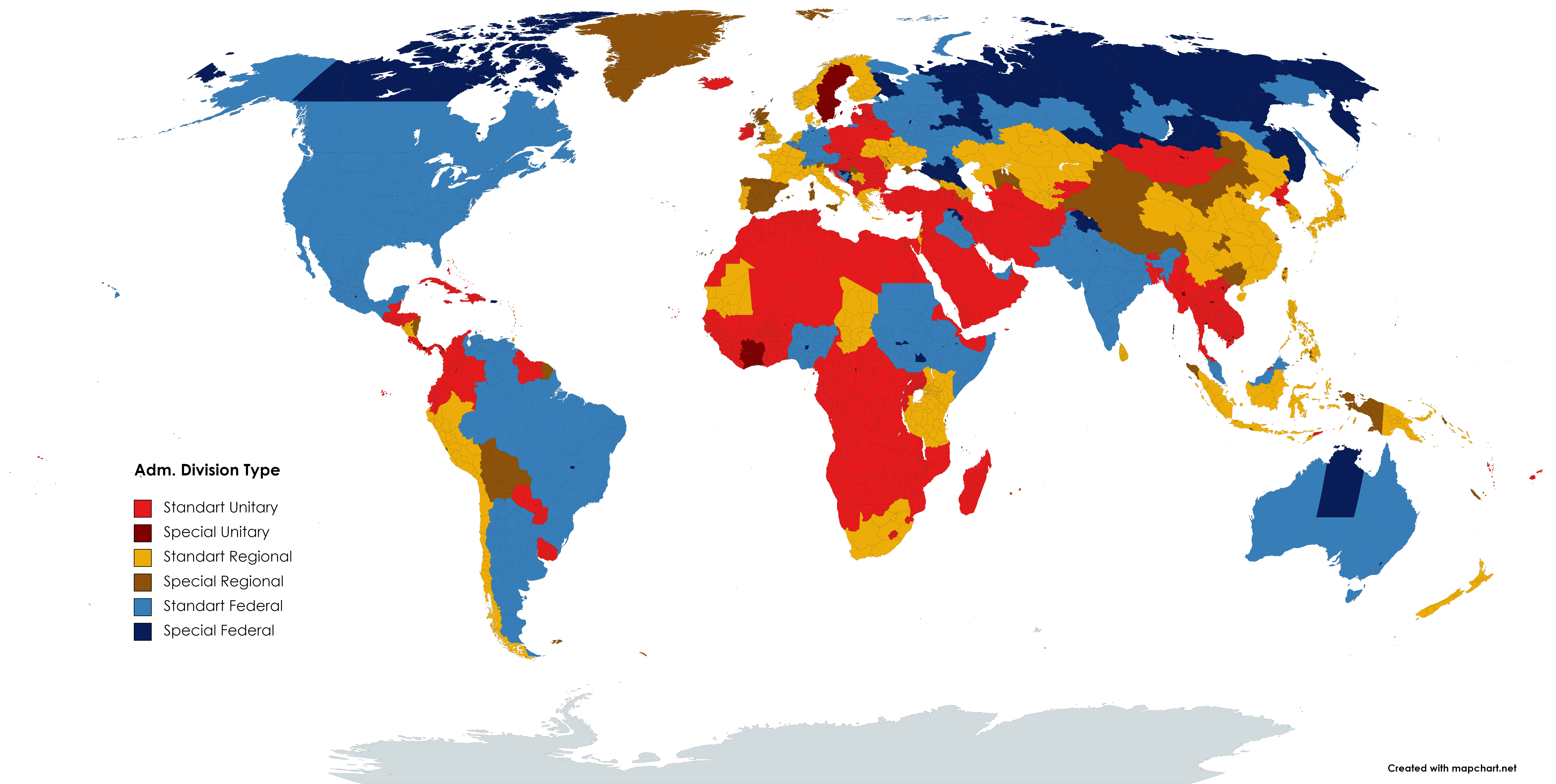
Now why exactly did I notice the things on Kazakhstan? Well I was looking for another source for administrative divisions and I stumble on MapChart site, it's a online map maker site that actually has an updated adm. divisions to 2023? It has the last changes in Indonesia's Papua rigions from last year for example, so it can be helpful despite not high definition and traceble...
However I took the opportunity and made this map based on that Wikipedia's list I comented on quite ago on federal, unitary and regional adm. divisions types, not perfect but that helps a bit, and yeah my comments on both Sudans federalism and the Iraqi federal entities being the governorates not Kurdistan Region and the rest of Iraq (the KRI still a thing but it's composed of governorates too)
- I did mess up a little bit the eastern Bangladesh minor rivers between Surma and Kalni rivers, I corrected it now; also I completely missed the HUGE wetland area there, which also host a permanent substantial lake/lakes area of Tanguar Haor near Meghalaya border, (although the Hukkanachhadi Beel and Nollah Haor could be permanent lakes too, but I'm not sure on these so they are part of the greater wetland), I put a single coast pixel there to show the Tanguar Haor, still little dubious, kinda;
- I also did add the wetland of the Atrai River in Bangladesh and also did add the Kosi River wetland in Bihar (there was massives floods there so it should be shown);
- Speaking of massive floods, I still didn't finish it but I'm also mapping the area flooded by 2022 Pakistan floods, since well it is a wetland are, I'm not so sure how to portray it (probably I'll need to get canals done for that);
- And updates on... Kazakhstan? Yep, two things there, one is that in it's nothern border with Omsk Oblast, in the part where it almost looks that there's a Russian enclave (which is not), it got painted as a water...
- The other update is more relevant, because this time there's an actual (pero no mucho?) Russian enclave inside Kazakhstan, the city of Baikonur is often forgotten that is leased and administered by Russia since 1991 til 2050 because of the Cosmodrome, going by my river map it should be around here, not sure on how to represent since it's not Russian land exaclty, but it's there now;
Now why exactly did I notice the things on Kazakhstan? Well I was looking for another source for administrative divisions and I stumble on MapChart site, it's a online map maker site that actually has an updated adm. divisions to 2023? It has the last changes in Indonesia's Papua rigions from last year for example, so it can be helpful despite not high definition and traceble...
However I took the opportunity and made this map based on that Wikipedia's list I comented on quite ago on federal, unitary and regional adm. divisions types, not perfect but that helps a bit, and yeah my comments on both Sudans federalism and the Iraqi federal entities being the governorates not Kurdistan Region and the rest of Iraq (the KRI still a thing but it's composed of governorates too)
Hi again, once more other update, hmm... Not gonna lie that this is driving me a bit crazzy but yeah, I tried making some sense on the Indus canal system + the canals on Indian Punjab, Harayana and Rajasthan... I pretty confident that the Pakistani ones and the Indira Gandhi canal are right, the other Indian ones are, let's say complicated...
Well here they are:


Of course there is more canals on India, but I think is better to search more in that
Well here they are:
Of course there is more canals on India, but I think is better to search more in that


I've been meaning to write up some long-overdue replies for some time now, but never quite got around to doing it. Eh, better late than never I suppose.
Well done on finishing the rivers of India. I'll go over the lakes you added in Tibet when I get to Tibet myself (probably at some point next year, once the Americas are done), but there shouldn't be any major problems when that happens.
I fear I'm about to give you quite a bit more work to do, as in a minute or two I'll be posting the next major patch, adding Quebec and the Labrador coast. Don't be surprised if it ends up taking a very long time to add the rivers - I've been diligently chipping away at it for nearly a month, though hopefully it shouldn't be as bad with the lakes and coastlines to work from.
One minor point - I may end up tweaking your rivers map in one or two places to get some of the raw geography to match up with the Raj patch, however that is a job I'll get to when I set about finishing the Raj over the next few weeks, so it won't be done immediately. A few minor corrections aside, I'll reiterate what I said above, congrats on a difficult job done well, I'm sorry for dumping Quebec on you out of the blue.
Y'know, I've had a few bad experiences trying to get stuff published; every now and again while at uni, I'd crank out a piece of coursework I was told was publication-worthy, only for a variety of things I won't be getting into here to get in the way and stop that happening, so I'd be a little wary of trying again.
Hey, it's not a complete waste; aside from R-QBAM patch itself, I've tried very hard to both highlight all the difficult decisions and iffy judgements I made compiling the Raj patch, as well as lay out the reasons I made them, and cite my sources throughout (both textual and cartographic) which should provide a good framework if anyone else wants to do another deep-dive. All the maps are right here if anyone possessing the GIS abilities I profoundly lack wants to have a stab at making a new improved dataset.
Firstly, it's great to see everything collated in one place, especially for someone as generally disorganised as myself, so thanks for doing that.
However I particularly like the Koppen maps, as they illustrate why this project has the potential to be so useful. Trying to warp such a map to fit the old QBAM would be a herculean task, considering the inconsistent nature and unknown projection of the latter map. For the R-QBAM however, it's as simple as finding the right dataset and reprojecting it, which is so much easier.
That's from the Directory isn't it?
It's both intriguing and infuriating as a source. On the one hand, it records so much local detail and trivia that has probably never been preserved elsewhere, and is peppered with little tit-bits and anecdotes like the one you highlighted. However it is also vague, imprecise and wildly inconsistent in places, meaning any conclusions drawn from it are by necessity highly uncertain. It's maddening.
My current working hypothesis is that the Nimsod hoax was a case of some incredibly minor Indian noble trying to falsify the record and make their ancestors look more important than they really were. Hence the shoehorning of the family name and purported state they ruled into all kinds of tangentially related articles to try and make the lie look more legitimate.
Based on that I'd say it's fairly likely that the two articles you highlight are probably dodgy as well, however I'd hold off on deleting them as there's always the chance the family did possess some territory at some earlier point, and that the embellishments and falsehoods only applied to later history. I personally suspect that this is not the case based on how much later history was invented or falsified, however as my researches have primarily focused on the petty states during the era of British rule, I wouldn't be confident completely dismissing the purported earlier history with which I am less familiar. I'd leave it be for now, though with a massive question mark over its validity.
I guess so? I would be unlikely to produce a historical map that old myself, as I'm such a perfectionist that I prefer producing historical maps from times when the sources are plentiful and precise enough that I can be pretty damn sure about the true extent and nature of the entities in question. I tend to stick to the 19th century or later for this reason, but if sources are good enough and people want it then I'll happily whip up historical geography patches as necessary.
Wait till you see the next patch.
Honestly, I'm not that worried about Chile; the difficult bit is about the same length and complexity as the Norwegian coastline, and that only took me a week and a half to finish back in May last year. Canada is sooooo much worse.
Thanks for pointing out that mis-coloured pixel in Kazakhstan (it has since been fixed). I try my best to make sure little mistakes like that don't creep in too often, but we all slip up from time to time.
I was really uncertain about how or even whether to show the Baikonur cosmodrome when I originally added Kazakhstan, though I eventually decided to omit it, in no small part because I couldn't for the life of me find consistent borders for the claimed leased territory. Plenty of maps and mapping services don't show it at all, while among those that do I've seen some wildly divergent portrayals of how big the leased area is, as that lease apparently covers quite a lot more than just the immediate area around the cosmodrome; I've seen maps giving Russia a massive random circle of the Kazakh steppes for example.
Adding first level admin divisions to the federal states that I've missed is a job I'm saving for later, when the main map is done and I can focus my efforts on just adding administrative levels to those countries missing them. It will be done, just don't expect it done soon.
As I said above, the next patch is coming soon.
And it's done!
Well, hi guys... Yeah I know another hiatus in my part, but hey the Indian Subcontinent is finished, at least on the physical side of things (the canals will happen soon, I hope)... Not gonna lie, the Brahmaputra gived me headcaches, but it is there now.
So taging @Tanystropheus42 (that btw congrats on the last updates) to show some lakes I did add, specially on the Hiamlayas just to make both Indus and Bramahputra basins complet, what is not in red are wetlands stuff so yeah
Well done on finishing the rivers of India. I'll go over the lakes you added in Tibet when I get to Tibet myself (probably at some point next year, once the Americas are done), but there shouldn't be any major problems when that happens.
I fear I'm about to give you quite a bit more work to do, as in a minute or two I'll be posting the next major patch, adding Quebec and the Labrador coast. Don't be surprised if it ends up taking a very long time to add the rivers - I've been diligently chipping away at it for nearly a month, though hopefully it shouldn't be as bad with the lakes and coastlines to work from.
One minor point - I may end up tweaking your rivers map in one or two places to get some of the raw geography to match up with the Raj patch, however that is a job I'll get to when I set about finishing the Raj over the next few weeks, so it won't be done immediately. A few minor corrections aside, I'll reiterate what I said above, congrats on a difficult job done well, I'm sorry for dumping Quebec on you out of the blue.
At this point I genuinely think you could compile all of this and look at submitting it to an academic journal.
Just add some conclusions at the end about the validity/usefulness of certain sources and use the 'I got an erroneous article deleted from Wikipedia' bit as a hook.
Y'know, I've had a few bad experiences trying to get stuff published; every now and again while at uni, I'd crank out a piece of coursework I was told was publication-worthy, only for a variety of things I won't be getting into here to get in the way and stop that happening, so I'd be a little wary of trying again.
I just wish all of this research didn't get lost on a few pixels, this could very easily be a big and detailed map or maybe even a GIS source.
Hey, it's not a complete waste; aside from R-QBAM patch itself, I've tried very hard to both highlight all the difficult decisions and iffy judgements I made compiling the Raj patch, as well as lay out the reasons I made them, and cite my sources throughout (both textual and cartographic) which should provide a good framework if anyone else wants to do another deep-dive. All the maps are right here if anyone possessing the GIS abilities I profoundly lack wants to have a stab at making a new improved dataset.
I present you the R-QBAM Repository !
R-QBAM Köppen climate maps:
Firstly, it's great to see everything collated in one place, especially for someone as generally disorganised as myself, so thanks for doing that.
However I particularly like the Koppen maps, as they illustrate why this project has the potential to be so useful. Trying to warp such a map to fit the old QBAM would be a herculean task, considering the inconsistent nature and unknown projection of the latter map. For the R-QBAM however, it's as simple as finding the right dataset and reprojecting it, which is so much easier.
Incredible work, I especially liked this hidden gem:

I think everywhere on earth has some version of this saying lol. It seems we all want to one-up each other when it comes to how extreme our local weather is.
That's from the Directory isn't it?
It's both intriguing and infuriating as a source. On the one hand, it records so much local detail and trivia that has probably never been preserved elsewhere, and is peppered with little tit-bits and anecdotes like the one you highlighted. However it is also vague, imprecise and wildly inconsistent in places, meaning any conclusions drawn from it are by necessity highly uncertain. It's maddening.
Well, there's as good a reason as any to revive my long-dormant Wikipedia account. Thankfully the successful article for deletion provides a pretty easy shorthand reference for the edit rather than having to justify it.
I believe there are now only 2 pages where a reference to some sort of Nimsod State-
It appears in a list of Talukas of Subha Prant Khatao in the article on Lalgun - which I'd appreciate clarification on whether this is correct, incorrect or one of these 'oh god we've got to go through the process of sourcing why that's incorrect' edits. Though that doesn't list a Raja of Nimsod anyway.
There's also an article on the hillfort at Bhushangad which I'm looking at atm and... well just removing the Nimsod Rajas is easy but the whole article seems to be full of suspect information. Which is impressive when I think you've written more words on summarising the difficulties of enumerating the total number of Princely States just there than are in the article.
There's also a fair number of references still to Gharge-Desai Deshmukh which refer to an article created by the guy who created the one on Nimsod State, but I'm honestly not sure if that isn't the 'one actual bit of history' the rest was built on.
My current working hypothesis is that the Nimsod hoax was a case of some incredibly minor Indian noble trying to falsify the record and make their ancestors look more important than they really were. Hence the shoehorning of the family name and purported state they ruled into all kinds of tangentially related articles to try and make the lie look more legitimate.
Based on that I'd say it's fairly likely that the two articles you highlight are probably dodgy as well, however I'd hold off on deleting them as there's always the chance the family did possess some territory at some earlier point, and that the embellishments and falsehoods only applied to later history. I personally suspect that this is not the case based on how much later history was invented or falsified, however as my researches have primarily focused on the petty states during the era of British rule, I wouldn't be confident completely dismissing the purported earlier history with which I am less familiar. I'd leave it be for now, though with a massive question mark over its validity.
When you get to the Tarim Basin, will you do Patches for the different levels of the Lop Nur Lake historically?.
I guess so? I would be unlikely to produce a historical map that old myself, as I'm such a perfectionist that I prefer producing historical maps from times when the sources are plentiful and precise enough that I can be pretty damn sure about the true extent and nature of the entities in question. I tend to stick to the 19th century or later for this reason, but if sources are good enough and people want it then I'll happily whip up historical geography patches as necessary.
Oh boy - time for the post-glacial fractal that is Canada. Good luck with that.
Wait till you see the next patch.
Can't wait for Chile
Honestly, I'm not that worried about Chile; the difficult bit is about the same length and complexity as the Norwegian coastline, and that only took me a week and a half to finish back in May last year. Canada is sooooo much worse.
- And updates on... Kazakhstan? Yep, two things there, one is that in it's nothern border with Omsk Oblast, in the part where it almost looks that there's a Russian enclave (which is not), it got painted as a water...
- The other update is more relevant, because this time there's an actual (pero no mucho?) Russian enclave inside Kazakhstan, the city of Baikonur is often forgotten that is leased and administered by Russia since 1991 til 2050 because of the Cosmodrome, going by my river map it should be around here, not sure on how to represent since it's not Russian land exaclty, but it's there now;
Thanks for pointing out that mis-coloured pixel in Kazakhstan (it has since been fixed). I try my best to make sure little mistakes like that don't creep in too often, but we all slip up from time to time.
I was really uncertain about how or even whether to show the Baikonur cosmodrome when I originally added Kazakhstan, though I eventually decided to omit it, in no small part because I couldn't for the life of me find consistent borders for the claimed leased territory. Plenty of maps and mapping services don't show it at all, while among those that do I've seen some wildly divergent portrayals of how big the leased area is, as that lease apparently covers quite a lot more than just the immediate area around the cosmodrome; I've seen maps giving Russia a massive random circle of the Kazakh steppes for example.
Adding first level admin divisions to the federal states that I've missed is a job I'm saving for later, when the main map is done and I can focus my efforts on just adding administrative levels to those countries missing them. It will be done, just don't expect it done soon.
As I said above, the next patch is coming soon.
I know I said in the last patch that I'd be spending a fortnight or so trying to finish the Raj, but that isn't what ended up happening. For a variety of reasons, I really wanted to get some more work done expanding the basemap, so much so that I didn't even mind that the next area up on the schedule was Quebec. It won't be too bad, I naively thought to myself, perhaps just another Scandinavia, which was difficult but doable. This was a bit larger, but I didn't expect it to take longer than a fortnight or so.
Then I got started, and quickly realised just how daunting the task I had set myself was. After a week I was beginning to regret the decision, largely because dealing with the fractal hell that are the thousands of Canadian lakes quickly became a real slog, but by that point I was far enough in that I wanted to finish it, no matter how long that took. What I initially expected to be a two-week job at maximum instead ended up taking the better part of a month, largely thanks to the hideous lakes of Quebec (to give you an idea, large chunks of Quebec look like this) and the many fjords of the Labrador coast. It was like combining the Norwegian coasts with the lakes of Finland, except here covering an area roughly five times as large.
I've really, really, really come to hate the Ice ages over the last three weeks.
So yeah, that's why today's patch took rather longer to finish than originally advertised; Canada is hellish, and there's even more left to do (yaaaay /s).
I also did a few other things, because by the end of the slog I really wanted to break up the monotony of endless fractal lakes with something a little different. I upgraded modern India to account for changes made while compiling the Raj patch (more on that below), changed up the colour scheme a little, merged the Americas with Afro-Eurasia and bashed out a couple of simple AH maps that may crop up in that map thread at some point over the next week or so if I can find the time to give them a basic write-up.
The biggest of the above-mentioned changes was India. I've said it a couple of times, but one of the main reasons I ploughed ahead with historical patches was that it gave me a chance to go over everything again. While putting together the historical geographic patch I ended up tweaking some of the existing Indian lakes, adding some and removing others, while also making a few tweaks to the coastline of southern India, particularly in Karnataka. These have been updated in this latest version of the map. Considering a lot of Raj-era borders correspond to modern first-level borders in both India and Pakistan, I also made a lot of tweaks where a more detailed look at the area in question found the original R-QBAM borders wanting. These have also been patched, bringing the modern map in-line with the historical patches as produced so far.
Random bit of trivia, but while surveying the lakes of Quebec I noticed something; by my count, there are no less than six meteorite impact craters visible on the R-QBAM as lakes in Quebec and Labrador; La Moinerie, Mistastin, Couture, Clearwater East, Clearwater West and Manicouagan. In the rest of the world finished so far, I can only think of three others off the top of my head similarly easily visible; the Siljan ring in Sweden, the lake at the bottom of the eponymous Karakul crater in Tajikistan and lake Bosumtwi in Ghana.
Earth has a fair number of impact craters, but most aren't that visible on the surface. Most have either been buried under later sediment, partially eroded away, deformed by later tectonic processes or some combination of the above. Quebec however is slap bang in the middle of the Laurentian Shield, an ancient expanse of continental rock that has been stable for billions of years, making it a big target that has existed for aeons to soak up any meteors headed its way. The Ice ages then came along and scoured away most later overlying sediment cover, revealing the impact scars in the bedrock beneath.
It's funny the odd things you notice spending weeks looking at endless fractal lakes.
Next up I'll be finishing the Raj patch (for real this time), and while I'm pretty confident that this will only take a fortnight or so, it may take longer, so don't be surprised if there's another long wait.
The other job that needs doing came about in large part thanks to having to slog through the lakes of Quebec; another lakes purge for the US, Mexico and Central America. Quite simply, northern Quebec is horrible. There are lakes everywhere, and so out of sheer necessity I was forced to be very selective when considering which bodies of water were big enough to be shown. On the other hand, when I originally did the rest of North America and the Caribbean, my standards for how big a lake has to be to be shown were rather lower, so I feel another purge of the smallest lakes is necessary to bring the two regions more in-line with each other.
Once both of those are done, the next patch will be the rest of Ontario, followed by Colombia and Venezuela.
Patch 93 - Oh, Canada 2 (Quebec and Labrador);
- Added Quebec
- Added Labrador, completing the province of Newfoundland and Labrador
- Added a few Nunavut islands close enough to Quebec that I had to add them out of necessity.
- Mildly patched the rest of Canada so-far completed.
- Merged the American frame-of-reference with the Afro-Eurasian frame-of-reference to produce one unified map.
- Related to the above, added the first bit of Brazil; the tiny Saint Peter and Saint Paul Archipelago, a cluster of isolated islands in the middle of the Atlantic under Brazil's sovereignty.
- Implemented extensive patches in the Indian subcontinent to account for changes made while compiling the 1914 Raj patch. These include some coastal tweaks, a further overhaul of Indian lakes, and extensive patches to inter-state borders in both India and Pakistan to bring the modern administrative borders in-line with their antecedent Raj-era borders.
- Tweaked the colour scheme in places to fix some long-standing issues I have had with certain colours. Germany and India received more muted variants of their previous colours, while Kuwait, Bahrain and Belize gained bespoke new colours.
At this rate, you will need a new body to fit all of the medals being pinned to you.
Alright, I didn't manage to draw anything this last week because of work and a trip I did that ended yesterday, so yeah; about Quebec and Canada in general, the trypophobia is REAL and very painful indeed, and that goes to the rivers too, at least the minor ones, the bigger ones are fine, but I wont catch up on that til I get the rework/upgrade of the rivers from the rest o N. America first, on the other hand about the changes in India well...Well done on finishing the rivers of India. I'll go over the lakes you added in Tibet when I get to Tibet myself (probably at some point next year, once the Americas are done), but there shouldn't be any major problems when that happens.
I fear I'm about to give you quite a bit more work to do, as in a minute or two I'll be posting the next major patch, adding Quebec and the Labrador coast. Don't be surprised if it ends up taking a very long time to add the rivers - I've been diligently chipping away at it for nearly a month, though hopefully it shouldn't be as bad with the lakes and coastlines to work from.
One minor point - I may end up tweaking your rivers map in one or two places to get some of the raw geography to match up with the Raj patch, however that is a job I'll get to when I set about finishing the Raj over the next few weeks, so it won't be done immediately. A few minor corrections aside, I'll reiterate what I said above, congrats on a difficult job done well, I'm sorry for dumping Quebec on you out of the blue.
It messed up rivers/canals a bit as I draw them based on the previous latest modern patch:
(Ignore the Himalayan lakes marked btw) I will definitely need to do an overhaul once the Raj patch changes get all done... Not that it's complicated to do it right now, but better get all done in a single update I think, also I always found odd that my main source had an weird path to the Indus on the area of the Punjabi enclave in Sindh, your new patch show me the reason for that
 Anyways, on the mean time I think can be doing the rework/upgrade on the rivers in Centroamreica and Antilles whitouth any problems, then going north as things get done, even with another lake purge incomming it wont get political borders redraw... I hope? Btw I have nailled the position of the Americas you are using in relation to the Old World on my map, wich helps a lot so kudos for us I guess.
Alex Richards
Donor
Based on that I'd say it's fairly likely that the two articles you highlight are probably dodgy as well, however I'd hold off on deleting them as there's always the chance the family did possess some territory at some earlier point, and that the embellishments and falsehoods only applied to later history. I personally suspect that this is not the case based on how much later history was invented or falsified, however as my researches have primarily focused on the petty states during the era of British rule, I wouldn't be confident completely dismissing the purported earlier history with which I am less familiar. I'd leave it be for now, though with a massive question mark over its validity.
Ended up leaving Lalgun alone, but seeing as the Nimsod Raja's didn't crop up in any other source I found on Bhushanagad that was easy enough to remove.
Converted an old counties map of mine into the updated North American Patch, let me know if there are any mistakes in the lakes or the counties.

Y'know, when I started this back in [checks calendar], bloody hell, February, I thought this would be a relatively easy job, and would take three weeks at worst to finish. It is now six months later, and while granted I spent one of those months grinding through Quebec instead, that's still five months worth of work for one historical patch. Damn my perfectionism. However, after a lot of work, I've finally got the Raj patch to a point where I can let it be and call it finished, at least for now.
As I've said previously, the Raj isn't anywhere close to done; it's still missing Burma/Myanmar and a couple of territories in the Middle East, and until those are added the Raj patch will remain incomplete. But finishing the Indian subcontinent does feel like a good place to put a pin in the Raj for now. I have other things I want to push on with, most notably finishing Canada, so I'll leave further work on the Raj for later.
This patch appears relatively simple on the surface, covering a single province (the North West Frontier Province, or NWFP) plus half a dozen mountain petty states under its aegis in addition to the more substantial state of Jammu and Kashmir. But, for a range of reasons I will attempt to untangle below, looks can be deceiving. The NWFP was, to put it bluntly, an utter mess. Kashmir at first glance appears to be similarly convoluted, however much can be simplified using the 'no vassals of a vassal' rule, though this still leaves the nebulous and poorly defined northern frontier.
To prevent this post from becoming another wall of text however, the relevant details are spoilered below. Once again I wanted this to be a quick job over a single post, but the length of the discussion has forced me to split the description into a double-post, with this post containing the detail on the NWFP and the following one featuring Kashmir, the maps and a number of useful addendums.
As I mentioned above, the NWFP was a mess of Princely states and petty autonomous tribal territories, while the sources describing the territory leave a lot to be desired. While this area wasn't the most difficult area of the Raj to untangle (looking at you Gujarat), it was nevertheless a challenge, largely due to the frontier nature of the territory. Borders were fluid and changeable, most of the mountain states were in a near-permanent state of civil war and low-level insurrection, while the quality of maps and records were markedly spotty, inaccurate or incomplete. Leaving aside the Princely states, much of the nominally British-governed territory was actually a confusing mess of Political Agencies and autonomous tribal territories that I have done my best to decipher and portray. In many ways, these were just as thorny an issue as the Princely States were, so I've described in detail why I portrayed them as I did following the discussion of the full States.
Written records, even those from otherwise reliable sources, are scant and inconsistent, while the maps I've been relying on are uncertain, unclear, missing from the records I have been using or mutually contradictory. In many cases, especially among the earlier maps of the NWFP, where there was no defined border to chart, the Survey of India instead decided to show no border at all, just the base physical geography of towns, roads and streams, forcing me to approximate borders based on guesswork, inference, later maps and the often uncertain and contradictory written sources. This issue of incomplete maps plagued my efforts to approximate the borders of both the Princely States and the autonomous tribal territories, and will be a running theme through much of the discussion concerning the NWFP.
It doesn't help that even otherwise reliable sources apparently falter in quality while covering this province. To highlight one particularly annoying example, hisatlas, a source I have relied upon extensively for my reconstructions of other areas, appears to have made some glaring mistakes in its reconstruction of the northern frontier of the British Raj. This map in particular is off in several respects, as a detailed search of other records relayed below should make clear. This, in addition to my other primary cartographic source (the Survey of India) often making the infuriating omissions mentioned above, made mapping the NWFP a particularly difficult and in many cases speculative enterprise.
Even the list of states was not fixed; one of the states depicted on this map would be abolished little more than a year later and incorporated into surrounding tribal districts, while a new State would be cobbled together by a particularly capable warlord from different tribal areas through the early years of the Interwar Era. I've been mulling over doing a 1947 Raj patch for the day before India and Pakistan gained independence, and this would be one of the larger changes that would need to be borne added.
For these reasons, I feel the need to put a disclaimer here - there is a lot concerning the administration and political borders of the NWFP that I am deeply uncertain of, with much of what I have chosen to portray on the map being educated guesses or speculation. It is very likely that I'm dead wrong on at least some of the details. I have tried my best to make sense of a deeply uncertain mess, and while I know I did a pretty good job, errors will have have crept in.
There is one more general point that I feel needs to be made before we move on to the explanations; the introduction of a new source. The Provincial Geographies are a series of books published through the 1910's and 1920, with each volume providing a general overview of the history, geography and administration of a different province, with smaller minor provinces and adjacent Princely States bundled into the discussion. I haven't used this source before because generally the other sources I have been using have been sufficient for my needs, however when it comes to the NWFP, I was so short on period sources that also provided descriptions of the tribal areas that I had to cast my net a little wider. In doing so I found a volume in the above series of books covering "The Panjab, North-West Frontier Province and Kashmir", published in 1916, which while vague and imprecise at times, does provide extra information regarding the tribal territories on the Afghan frontier.
With all that out of the way, on with the explanations, starting with the full states. After quite a lot of digging, I've belatedly come to the conclusion that there were five Princely States under the aegis of the North West Frontier Province in July 1914, although basically all of those are in some way uncertain. Either there was some uncertainty over whether the entity in question was a state or not, poorly-defined or changeable borders or both of the above simultaneously.
About the only state I can be certain of is Chitral. It is mentioned consistently across sources, and appears to have a relatively fixed territory that doesn't fluctuate too much. I have found some references to a territorial exchange where Chitral gained land from Kashmir, but as that apparently took place in April 1914 it is thus outside the scope of this map, and can be safely ignored, as the post-exchange border is, as far as I can tell, the same as the modern border between two of Pakistan's provinces (Khyber-Pakhtunkhwa and Gilgit-Baltistan, in case you were curious). Chitral survived for a surprisingly long time as an autonomous region in Pakistan before being integrated directly, but even then the old Princely state maintained its territorial integrity as a district until it was split in two in 2018, so modern borders were actually pretty handy here.
Next up, Dir (occasionally alternately spelled Dhir). Unlike the following two states, I'm pretty certain that Dir was considered a state in 1914, though as ever there is some uncertainty. Most notably the 1909 Gazetteer is particularly vague, as it provides no individual listing for Dir. Instead, you find an infuriatingly brief entry on "Dir Swat and Chitral", a political Agency covering the Princely States of Chitral, Dir and Nawagai, in addition to a varied collection of autonomous tribal territories, most notably the Swat lands and Buner. This entry goes into detail about none of them, though some notable sub-components do get their own listings (that still fail to clear up a lot of inconsistencies). This is a bit of a pattern by the way, with quite a few other sources from before or during the First World War, most notably the Provincial Geography (1916), describing the Agency collectively and spending little time enumerating its component parts.
This adds a little uncertainty to my conclusion that the states contained within the Agency were regarded as their own distinct entities, however it can just as easily be argued that this effect of merging the States and tribal territories together in discussions was due to either laziness, or overzealous simplification on the part of the original authors. The latter interpretation may even have been a necessity at the time said sources were written, as the territory had only recently been acquired and pacified by Britain in the 1890's, and thus information on specific governance may have been thin on the ground for the average writer. On balance, I have come to think that the latter explanation is the most likely explanation for such abbreviated descriptions. In particular, it should be noted that there are other sources (for example contemporary editions of the Memoranda) that attest to the separate existence and recognition of Dir state and others as full Princely States, so I shall follow that convention here.
Drawing on the borders of Dir wasn't as bad as it could've been. The border with Chitral followed a chain of mountain peaks and remained as such long enough to be charted on more accurate Survey of India maps, while in the west I had to make do with the borders portrayed on the rather incomplete but good enough for my purposes Sheet 43/A Kalam (1921). The main map is missing quite a few borders, but does show the rough location of mountain peaks that such borders would likely follow, as well as containing an inset map detailing administrative control of the territories depicted, which I used as my primary source. To the south-east the border follows the Swat River (more on that border below), while the border to the south-west followed more rivers then the peaks of another mountain chain. I think the latter border was established in the 1890's, when Dir came to an agreement with the rulers of Nawagai, establishing a frontier between the two states following the recent annexation of the Khanate of Jandol by Dir.
In the case of Dir, I am actually strangely fortunate to have set the date of the map at July 1914, thanks to a messy series of events related by both the 1916 and 1939 editions of the Memoranda. The old Khan who had first entered into treaty relations with the British government in the 1890's, died in 1904. His eldest son inherited, but another son felt that he had just as strong a claim to the throne as his older brother, and began plotting to usurp the throne, beginning a protracted succession crisis. Low-level rebellions and insurrections backed or organised by rival claimants wracked the state for nearly a decade. The British government never got strongly involved as both sides were wise enough not to attack the main military road running through the territory, which would likely have provoked a harsh response had it been rendered unpassable. Things came to a head over the summer of 1913, when, through an alliance with the mountain tribes, the younger brother was able to drive off the British-recognised Nawab, ruling in Dir for two months before he himself was ousted by the elder brother and his own alliance of mountain tribes. For a year, the State of Dir was largely anarchic, with the Nawab in Dir holding little power and his younger brother causing chaos in the countryside. In an odd stroke of luck for me however, the younger brother was assassinated in June 1914, with the revolt melting away faster than an ice cube in the Sahara following his death. Thus in mid-late July 1914, Dir was unified and peaceful for the first time in a decade, so I don't have to bother showing much of the countryside in a state of ungoverned anarchy (unlike in Bajaur, more on that mess below).
There is another detail that bears mentioning, as it pertains both to the territorial extent of Dir and the later creation of Swat state, in 1914 still more than a decade away from being realised. The 1939 Memoranda also mentions that the Khan of Dir annexed the territories of the right-bank Swat tribes to his state in the spring of 1897. This little territorial adjustment is visible in several period maps from the Survey of India (most notably Sheet No. 43 NW Frontier Province (1916) and Sheet 43/B Mardan (1913), downloadable here and here), which show a border following the Swat river. Though it isn't explicitly stated who the right-bank Swat territory belonged to, in conjunction with the information from the Memoranda it can be safely assumed to be a possession of Dir.
But Dir would not hold onto these territories forever. In 1915, the right-bank Swat clans rebelled against the authority of Dir, kicking off another round of revolt and anarchy as every petty khan and tribal leader took their chance to carve out some power for themselves or settle old grudges. I won't go into it in detail here - it's outside the scope of the map, so I wasn't looking that hard for sources, but from what I can tell things got messy. The Nawab of Dir would be able to quell the revolts after a few years, but he was never quite able to crush the one that started the whole mess among the right-bank Swat tribes. After booting out their original leader following a string of Dir victories in 1916, the revolutionaries instead settled on the grandson of a man who had held significant temporal power in the Swat valley back in the 19th century. This is important to mention, as some later sources, most notably worldstatesman, use the 19th century warlord domains as the beginnings of their lists of Swat monarchs, never mind that that dynasty lost its temporal power in the 1860's. The new leader, with a history of family rule in the area, proved to be a fairly adept state-builder, cobbling together the clans of the Swat valley and the Buner tribal area into a fairly cohesive state. This campaign picked up steam in 1919, when they finally inflicted a crushing defeat on the Nawab of Dir, forcing him to finally relinquish his right-bank Swat territories, then spread into the tribal districts to the south east before consolidating the new de-facto state around 1922. This territory would belatedly be recognised by the British government as a proper Princely state in May 1926, making it, as far as I can tell, the youngest Princely state in the Raj.
Recounting the story of the founding of Swat State helps me explain why my borders for Dir state differ substantially from later sources. During its formation, the new state of Swat would take a significant bite from Dir, de-facto from 1919 and de-jure from 1926. Later sources, for example the CIA, National Geographic and Hisatlas, depict the situation after the creation of Swat, whereas of course I am attempting to depict things at an earlier date, hence the substantially different borders.
Next up, Amb and Phulra. These two states go hand in hand, as they were splinters of a previously more substantial entity, most commonly referred to though the sources as feudal Tanawal. When Britain took control of this part of what would become the NWFP following the conquest of the Sikh Empire in the 1850's, a rather odd arrangement was established with the ruler of the larger of these chunks, the Princely State of Amb. The old state of Tanawal was divided in two, with the Nawab of Amb remaining a Princely ruler in his domains on the right bank of the Indus (the Princely state of Amb), while being a feudal landowner with some associated rights but ultimately under British sovereignty in his left bank territories (the aforementioned feudal Tanawal). Phulra was established under an offshoot dynasty in the early 19th century, and was thus excluded from the above arrangement, though on notably uncertain terms.
Now, I know for a fact that by the end of the Raj both of these entities were considered full states, and would become protectorates of the newly independent Pakistan once Britain left the subcontinent in 1947. Amb in particular lasted as a distinct territorial entity all the way till 1969. They also show up in plenty of later maps and sources, most notably hisatlas, that depicts its take on the situation in the NWFP and Kashmir in 1947, right before independence. The question is this - were Amb and Phulra considered states in 1914, or were they regarded as feudal landholders with some autonomy but not full states?
As with Dir however, quite a lot of contemporary sources make little mention of the two related states, or mention them collectively. The 1909 Gazetteer for example discusses the two together, in one article that briefly outlines the history of the Tanawal estate. Notably, while that entry doesn't explicitly state that the two related entities were outright Princely States, it does attribute significant state-like trappings to both of them (significant judicial and legislative autonomy, possession of royal titles, stull like that). Just as with Dir, other sources are similarly nebulous. The Provincial Geography (1916) describes the area thusly; "Feudal Tanawal is a very rough hilly country between Siran on the east and the Black Mountain and the River Indus on the west. It is the appenage of the Khans of Amb and Phulra".
I think you'll agree, not much to go on. But the plot thickens. As mentioned, period maps of the NWFP are notably spotty, however one of the few things that is reasonably consistent is to show Amb and Phulra as distinct entities, although once again I must introduce a note of caution. This is because those same maps also consistently show feudal Tanawal, a tract that all sources unanimously agree was British under a local landlord. This is done by the aforementioned Sheet 43/B Mardan (1913) (that unfortunately only shows a thin sliver of Phulra on the edge of the map) and Sheet 43/F Abbottabad (1923). There is also the fact that nowhere are these entities referenced as full states (in contrast with other maps from the same series that clearly delineate states from non-states), which is also worrisome, along with some wider scale maps (e.g. Sheet No. 43 NW Frontier Province (1916)) that show Amb (albeit in a low-key way), but crucially not Phulra. There is further evidence that these two related states were not treated the same, most obviously in the lists of worldstatesman. Firstly, this source confirms that Amb was in relations with the British and treated distinctly, but in its entry on Phulra claims that that state was only upgraded to a full Princely State in 1919. This of course accords with the above omission of Phulra in a map from 1916, heavily implying that while it existed as a distinct entity, Phulra wasn't yet considered a full state, in contrast with Amb.
But again, there are always more sources to provide ample evidence for alternate interpretations, in this case the many editions of the Memoranda. Multiple contemporary editions of the Memoranda from before 1919 mention Phulra in their lists of states alongside more certain states like Dir and Chitral, as well as of course Amb. But while this appears to provide solid evidence in favour of the inclusion of Phulra, it should be noted that the Memoranda isn't a completely reliable source. On occasion in the past I have disregarded its conclusions in favour of overwhelming evidence from other sources against them, most notably in the case of the Baluchistan states mentioned previously. It should also be noted that the 1907 edition of the Memoranda doesn't mention either Amb or Phulra, however I don't feel this is a garing enough omission to change my conclusions. In conclusion, while I'm fairly certain I'm right to show Amb as a Princely State for the reasons outlined above, I will admit that I'm sticking my neck out a little to show Phulra in the same way. The evidence is incredibly scant, and I came very close to omitting it (or at least, omitting it from this map, as the case for its being a state is much better after 1919), but ultimately decided to include it. If I ever get around to re-doing the 1914 Raj patch (which I may do at some point - I've never quite been able to leave something alone if I'm not completely happy with it), Phulra may get removed for the reasons discussed.
The final state to mention is perhaps the most enigmatic, Nawagai, commonly also referred to throughout the primary literature as Bajaur. In this case, once the usual filter of uncertainty and squiffiness in the period sources is accounted for, I'm pretty certain in my conclusions. Nawagai/Bajaur was a small state on the border with Afghanistan, that was apparently abolished in 1915 and its territory incorporated into a neighbouring tribal territory. Nawagai is mentioned tangentially or directly in multiple sources. As we saw before, the 1909 Gazetteer mentions it but isn't exactly clear on the specific status of the territory. While it isn't spelled out however, the Khan of Nawagai is name-dropped as an important local notable who holds nominal hereditary control over the territory of Bajaur, which is a pretty significant piece of evidence in favour of Nawagai being a Princely State [1]. Nawagai also appears under the name Bajaur in the hisatlas map of the NWFP, and is marked in outline as a former state (unsurprising considering that map is set in 1947). That map also provides my only citation for the recognition of the state being withdrawn in 1915, aside from the fact that it appears sporadically in earlier lists but never in later sources. On the other hand, in an apparent major omission, worldstatesman doesn't mention Nawagai at all in its relatively brief list of Pakistani Princely States, which could be counted as a major strike against the existence of the state, but which I think is instead a notable glaring error from an otherwise exemplary source.
Further support of the state status of Nawagai is its listing in multiple contemporary editions of the Memoranda, from 1907, 1911 and 1915, that all consider it a full state. The latter source is particularly notable as it discusses the status of Nawagai perhaps months before the revocation of its Princely status by the British, granting a window into Nawagai's final days as a Princely State of the Raj. The picture it paints isn't a pretty one, but more on that below. In conclusion, in spite of some glaring omissions, I feel that the balance of evidence suggests that Nawagai was indeed recognised as a state in July 1914, even if that status was soon to be revoked.
The main problem concerning Nawagai is that basically no map I've yet found beyond the in-this -case-dubious hisatlas actually shows the borders of this state. I have three maps that cover the right area at the right date; Afghanistan (1914) (downloaded here), Sheet No. 38 Punjab (1910) and Sheet 38/N Peshawar (1911). None of them show any borders for the State of Nawagai at all. Not even in inset maps. There are a few Survey of India maps covering the same area published later that include a few more borders, however as they were published after Nawagai had been disestablished they understandably don't show it. This is by far the worst case I found of the Survey of India just not bothering to show an undefined border if they had no firm sources on what it looked like, which is especially annoying as in this case an entire Princely State is effectively omitted from the cartographic record. That's not to say that these maps aren't useful; they do show in about the right place, a cluster of interconnected valleys ringed by notable hills that is labelled 'Bajaur'. As the icing on the cake, the town of Nawagai can be found nestled in the foothills of the fringing mountains in the far south-west of the region. The borders of Nawagai depicted here are thus a very uncertain compromise, based largely on a mash-up of the borders claimed by histalas and the natural geographic boundaries that probably formed the border between Nawagai and the tribal territories to its south-west. I would've liked to have based them on something more concrete, but considering the general dearth of sources this'll have to do.
But it gets worse. As mentioned above, in the final years of its existence as a Princely State, Nawagai was not in a happy place. As recorded in the 1909 Gazetteer, the area had long been divided between the domains of multiple petty Khanates subordinate to the Khan of Nawagai, and usually headed by a close relative. This system of multiple petty vassals, often led by men with a reasonable claim to the throne in Nawagai, was, however, a bit of a tinderbox, for what should be obvious reasons.
As recounted by the 1916 Memoranda, the state was plunged into anarchy in 1906, when the crown prince went into rebellion to prevent a favoured younger brother from supplanting his position. As in the example of Dir recounted above, this rebellion was for a time, successful, with the rebelling heir ruling in Nawagai for a few months before being forced out in turn. While father and son would later reconcile, this power struggle apparently broke the back of the Khanates' tenuous control of the wider Bajaur area, with the many petty vassals under its nominal control asserting their independence. According to a passage in the 1916 Memoranda; "The Khanate in latter years has lost much of its power and holds little if anything more than the tract known as Surkamar, in which Nawagai is situated. In the spring of 1913 the Nawab helped by his son, Muhammad Ali Jan, made an effort to recover some of his lost possessions from the Safi, Gurbaz and Mohmand tribes, but was defeated and the Nawagai bazar was burnt." From textual clues in the rest of the text, it appears that that paragraph is a reprint of an edition first written in 1913, so such a description of shattered government control restricted to just the area around the capital while supposed vassals do as they please and neighbouring tribes occupy land for themselves is almost certainly contemporary for July 1914. For this reason, only a small section of the area I allotted to Nawagai is actually coloured as a protectorate around the eponymous capital, with the rest coloured in anarchic grey.
I hope I have conveyed over the last few dozen paragraphs just how much trouble only five states can cause if the sources are uncertain or questionable. With the Princely States out of the way however, we move belatedly onto the matter of the autonomous tribal territories, which were somehow even worse.
The key problem here is that the sources are even more thin on the ground. The states were, well, states, and thus even if they only get a perfunctory mention, the vast majority of textual sources do mention them, and most maps show them (with exceptions, see the discussion of Nawagai above). These were semi-sovereign entities in subsidiary relations with the British government, of course they receive more attention from the primary sources. And when said primary sources are as spotty and contradictory as they were for the states of the NWFP, it should be no surprise that the tribal districts are practically never discussed, and when they are, it is brief, vague and perfunctory. It doesn't help that one of my best sources is useless here, as the many editions of the Memoranda by their definition cover only the states in relations with the British government, not the British administered districts and tribal autonomies.
For those reasons, the map I ended up constructing to portray what I think the tribal borders may have been was by necessity largely guesswork. I had to largely cobble together my map from a collection of individually-in-their-own-way-iffy Survey of India maps using the questionable hisatlas map as an overarching framework. It's a bit of an uncomfortable mashup as a result, built on a foundation of uncertainty, contradictory sources and educated guesses. But it's the best I've been able to construct, so it'll have to do. That's not to say it's all bad - those sources do agree on quite a lot, I was able to dig up textual citations for a fair number of my assertions, and quite a few individual Survey of India maps are fairly accurate and detailed. It is where accuracy drops off and contradictions creep in that the uncertainty is generated.
Unlike with the last two provinces possessing semi-autonomous frontier Tribal districts (Assam and Baluchistan), there were too many under the NWFP for me to just describe them one by one. To help keep track of which tribal area is which, I've also included a sub map that labels each territory as an addendum in a spoiler at the bottom of the following post. It should also be noted that there is some differing terminology in the primary sources surrounding these territories. Four of them (Khyber, Kurram, Northern Waziristan and Southern Waziristan) were officially 'Political Agencies', theoretically under the direct control of the local Political Agency but in reality largely left to themselves to be governed autonomously. I thus elected to not bother distinguishing between standard tribal territories and Agencies, because de-facto they were governed in the same hands-off way.
In our tour of the tribal areas of the NWFP, I'll start with Buner in the north-east, then work my way around the province in a vaguely anticlockwise fashion, giving a brief rundown of each tribal territory in turn. The first, the aforementioned Buner, is probably one of the better supported ones. It has a citation from the 1909 Gazetteer, albeit a rather vague one, and it appears plain as day on two contemporary Survey of India maps we've met before; Sheet 43/B Mardan (1913) and Sheet No. 43 NW Frontier Province (1916). It is thus a relatively uncontroversial addition, with fairly well defined borders to boot. A decent chunk of Buner would end up annexed to Swat when the latter state coalesced over the next decade, while hisatlas attests that what was left was merged with a portion of what I think is Indus Kohistan (see below) to form a new tribal district. That was all in the future however.
Next up, one I was expecting to be difficult but actually turned out to be easy; Swat. I have already relayed in detail how Swat state would come to be over the decade following 1914, so will not repeat myself here. Leaving that aside, the precursor Swat tribal territory was, in essence, what was left of the Dir Swat and Chitral Agency once you got rid of the Princely States, Buner, Utman Khel and Sam Ranizai, and encompassed a tract of land along the Swat river. As relayed by the 1909 Gazetteer, at the time the territory of Swat proper could be divided into two domains; true Swat (or Swat-proper) and Swat Kohistan, with half of the former annexed to Dir (see above), and the latter more rugged and mountainous. Confusingly, that entry in the 1909 Gazetteer (which also relates a history of the surrounding country), labels the territory "Swat State", even though I have good sources and maps that say otherwise. I think this is another holdover of the precursor ephemeral Swat State mentioned by some sources, so I chose to disregard it. Honestly, the citations for Swat are all over the place, and the maps laughably contradictory (see the discussion on the particularly poor Survey of India sheets covering Swat Kohistan above), but in an odd way it was one of the easiest ones to do, by dint of it being the last territory I finished in the area. I spent ages finishing all the other problem borders around it, only to later come to the pleasant realisation that by doing all that I had already mostly finished Swat by default. What I had produced aligned with the descriptions of the territory I could glean from the primary sources, so I left things at that and moved on.
I'm actually going to treat the next two areas, Sam Ranizai and Utman Khel collectively, as I was able to find very little of them and what I was able to dig up was very similar. Of the two, Utman Khel has more attestations, I suspect largely because Sam Ramizai was smaller and more insignificant. Both are mentioned in the aforementioned entry on Swat in the 1909 Gazetteer that also recounts the history of what would become the Malakand Agency, however only Utman Khel gets its own short article, apparently confirming the distinct existence of the tract. Both are however mentioned distinctly in the Provincial Geography (1916), which also confirms that Sam Ranizai was a sliver of tribal territory between the border of the British districts to the south and a range of hills to the north. Unfortunately, both of these territories fall into the same cartographic grey area that made Bajaur so difficult to complete, occupying the same flawed Survey of India sheets as Nawagai (Sheet No. 38 Punjab (1910) and Sheet 38/N Peshawar (1911) specifically). In an earlier draft version of the map, I actually merged these two territories in with Swat, based on the absence of borders and the vagueness of the Gazetteer entry, however I decided against this on finding a few more sources. This decision remains a little provisional however, a problem confounded by the lack of cartographic sources.
Next up is Mohmand. Hisatlas informs us that it would be elevated to a Political Agency in 1947, however I can be pretty certain that it existed as a distinct territory before then for a number of reasons. Firstly, while we are still dealing with the same less-than-helpful borderless Survey of India sheet as above (Sheet 38/N Peshawar (1911)), in this case the map is a little more helpful, as it includes an inset map that clearly demarcates the Mohmand territory as a distinct entity, even if no defined borders are shown on the full map. It also gets a few period citations, most notably in the 1909 Gazetteer, that confirms its existence and separation from the more conventionally governed settled British districts, and in the Provincial Geography (1916). The latter sources straight up describes the tract "as convenient a neighbor as a nest of hornets", and does not dwell on it much. That description also includes the territory of the Mallagori tribe, which both sources actually state was under the Khyber Political Agency.
Speaking of which, Mohmand is followed by the Khyber Agency (sometimes alternately spelled Kaiber in period sources), which fortunately is much better attested. We are by now out of the infuriatingly vague Sheet 38/N, and back to more consistent and reliable sheets in the Survey of India collection, which coupled with the fact that the SoI and hisatlas maps agree almost exactly (there are a few slightly divergent borders too small to need accounting for at this scale), is a very good sign. The northern border does cut through Sheet 38/N, however here I'm pretty sure it follows a river border, so for once map-uncertainty doesn't matter. That's not to say that the Survey of India is completely off the hook; both Sheet 38/O Mianwali (1912) and Sheet 38/K Bannu (1912) are just as vague and devoid of useful borders as Sheet 38/N. Crucially however, both maps also come with more helpful later editions that do provide borders (Sheet 38/0 Kohat (1929) and Sheet 38/K Parachinar (1930) respectively)and both of the more contemporary originals also include inset maps that on a broad scale confirm the same borders as appear on the later editions.
Oddly, the Khyber Agency doesn't appear as conspicuously as you would expect in the period sources. The Provincial Geography (1916) doesn't mention it, while it doesn't get a distinct entry in the 1909 Gazetteer, instead being mentioned heavily in an entry just termed "Khyber". Honestly, in the latter source, it really looks like two entries, one on the Khyber Pass and another on the Khyber Political Agency have been awkwardly combined into one, which is both annoying and a little confusing to read. This citation does however prove its independent existence prior to the First World War. All of this amounts to a decent level of attestation and an easy addition to the map.
Next up, another enigmatic one, the Orakzai tribal territory (or at least, what I assume is the Orakzai tribal territory). This is barely ever mentioned in the primary literature; the 1909 Gazetteer has one of the shortest, least helpful entries I've yet seen, while an entry on the Orakzai and some related clans in the Provincial Geography (1916), while longer , still provides scant detail. But at least there are some references, however tenuous. For this one I had to largely work off maps, which for once paint a surprisingly cohesive picture. It took a little wrangling to make sure, but here hisatlas and the Survey of India are on the same page. Sheet 38/K Parachinar (1930) shows a tract of tribal territory to the south of the Khyber Agency labelled Orakzai, that lines up remarkably well with a similarly labelled tribal territory on hisatlas' NWFP map. To confirm this was the same border in 1914, I took a look at Sheet 38/K Bannu (1912), which, while distressingly devoid of useful political boundaries, does contain an inset map that labels the right area as "tribal territory", so I know that that tract was tribal territory as far back as 1912. However, the scarcity of sources leaves some alternate options on the table. It remains possible that this territory was actually further subdivided among multiple tribal territories, and Orakzai was just one of the more prominent ones. Indeed hisatlas labels the eastern panhandle of this territory "Adam Khel" as if it were a separate territory. However Sheet 38/O Kohat (1929), which otherwise shows several uncertain or approximate borders, makes no distinction between the main bulk of Orakzai territory and the eastern panhandle, so I followed that map and discarded hisatlas' suggestion (a decision made easier by the apparent lower quality of this hisatlas map in relation to others from this source).
In contrast to the above, the Kurram Agency is fairly well attested, getting a full entry in the 1909 Gazetteer and a lengthy mention in the Provincial Geography (1916), and appearing in several period maps. There is some evidence that the Kurram Agency was governed in an oddly different way. The 1909 Gazetteer map for example shows it as British territory, in stark contrast with the rest of the Agencies and tribal areas of the NWFP, while the Provincial Geography (1916) states of the Kurram Agency that "Though under British administration, it does not form a part of any British district". I would however put these discrepancies down to the semi-autonomous nature of the Political Agencies as related elsewhere, though why the Kurram Agency got singled out for unique treatment remains unknown. Aside from this little niggle nothing stands out among the primary sources, with the exception of an apparent glaring error in the hisatlas NWFP map expounded upon below.
Quite simply, in this case I think histalas is stone cold wrong. I relate a few other instances where the usually reliable hisatlas apparently falters in relation to the Waziristan Agencies below, however this screw up is notable enough to be detailed separately as well. Here, the eastern border shown by hisatlas does not in any way align with the border as seen in period maps, neither the 1909 Gazetteer map cited already nor the maps of the Survey of India. Specifically, while Sheet 38/K Bannu (1912) remains distressingly free of borders like other uncertain maps of this series, once again the inset confirms the non hisatlas borders, which are provided in great detail courtesy of Sheet 38/K Parachinar (1930). I won't even bother dwelling on this for too long - hisatlas is wrong, presenting a border completely at odds with that shown by several contemporary historical maps. In spite of a previous good record, it is clear that alas this hisatlas map is lacking in quality compared with others from that source I have relied on fairly heavily when reconstructing other regions.
Before discussing the twin Waziristan Agencies, I feel it best to discuss the Bhittani tribal territory first to get it out of the way. This one appears clear-cut at first glance, but hides some uncertainty. First point, the territory is consistent across many maps. Here hisatlas is in agreement with the many maps of the Survey of India, most notably the contemporary Sheet 38/L Bannu (1912) and Sheet 38/L Bannu (1918), in addition to others. There are, however, exceptions. Afghanistan (1914) shows the territory under Dera Ismail Khan District, while Sheet No. 38 Punjab (1910) shows it as part of Southern Waziristan, as does the 1909 Gazetteer. Here I shall err on the side of the more detailed local maps over the wider regional maps, particularly considering I have already raised the flawed and inaccurate nature of Sheet No. 38 Punjab (1910) in particular already.
Textual citations are thin on the ground, but do exist. While the Provincial Geography (1916) is silent on the Bhittani territory, the 1909 Gazetteer does have a short entry on the Bhittani tribe as a whole, that also describes their land. A distinction is made between the Bhittani living in unquestionably British land, and the "independent Bhittanis" granted more autonomy in the mountainous tract of their traditional territory. The geographic description given for that area ("about 15 miles wide and 25 miles long, extending from Spinghar and Jandola on the west to the foot of the hills at the Bain pass on the east, and from Gabarghar on the north to Girni Sar on the south") accords extremely with the maps of the Bhittani tribal territory included in the above-mentioned maps of the Survey of India. However, there is a problem, as the 1909 Gazetteer also claims that "The independent Bhittanis are politically controlled by the Deputy-Commissioner of Dera Ismail Khan." Needless to say, this is problematic, as it implies that the Bhittani territory was in some way dependent on the neighbouring British district. On the other hand, hisatlas implies that other tribal territories such as Orakzai were also subordinate to British districts and were still shown distinctly anyway, and the fairly consistent record from the Survey of India has to count as another plus. In the end, it was the maps that swayed me into including it, as this is a rare topic on which hisatlas and the Survey of India can apparently agree, in addition to countless other maps that show that the area in question was at least governed somewhat at arms length (see the already mentioned 1909 Gazetteer map for another example).
The two Waziristan Agencies, Northern and Southern, are pretty uncontroversial so I won't dwell on them long. Both have full articles in the 1909 Gazetteer, and are mentioned collectively by the Provincial Geography (1916) in rather unflattering terms. They also appear fairly consistently on the maps of the Survey of India, with reasonably consistent borders, though there is some confusion here too. In particular, I spent most of a day touching up a rather large composite map compiled in 1939 from two full Survey of India sheets and bits of four others, as it was the only map covering Sheet 38/H in any level of detail. Cleaning up Sheet 38 H, L, & Parts of 38 G, K; 39 E, I (1939) was quite the endeavour, but a worthwhile one considering it confirmed most of the borders I suspected from other sources.
These borders also largely accord with those given by hisatlas, however as is becoming regrettably common, there are two major problems with the 1947 histatlas map one concerning Northern Waziristan and the other Southern. The first concerns Northern Waziristan, and is perhaps the most glaring error in this overall sub-par hisiatlas map, the supposed Ahmadzai tribal territory. I'll be blunt; I don't think it existed. There is no entry under that name in the 1909 Gazetteer, it isn't mentioned in the Provincial Geography (1916), and literally every period map I have dug up covering the region instead attributed its territory to Northern Waziristan. This goes for Sheet 38/K Bannu (1912), Afghanistan (1914), Sheet No. 38 Punjab (1910), Sheet 38/K Parachinar (1930), and the aforementioned composite Sheet 38 H, L, & Parts of 38 G, K; 39 E, I (1939). I have found no trace of the existence of Ahmadzai tribal territory even though hisatlas confidently displays it, with every other source allotting its supposed territory to Northern Waziristan. It remains possible that this division was cleaved off Northern Waziristan in the 1940's which would make hisatlas accurate for 1947 at least, however the evidence overwhelmingly points to it being a part of Northern Waziristan in 1914.
The second issue concerns the southern-most portions of Southern Waziristan, in particular the Shirani country and Usterana. In quite a few maps, perhaps most notably this one included with the 1909 Gazetteer, Southern Waziristan has a notable panhandle that projects to the south all the way to the border with Punjab. However, not all maps show this, with the more detailed Survey of India maps in particular showing most of the midsection of that panhandle as part of the directly-administered Dera Ismail Khan District (the far south of the panhandle, Usterana is often shown distinctly, but is detailed further below). That midsection comprised the lowland portions of the Shirani country, a region divided politically between two provinces, with the highland Bargha Shirani under Baluchistan and the lowland Largha Shirani under the NWFP. From what I can tell from the short description of the tract in the 1909 Gazetteer, and the even briefer description relayed by the Provincial Geography (1916), the area was directly administered with some token autonomy I felt wasn't notable enough to show. Hence, in contrast to some sources (hisatlas included) I chose not to depict this tract in the 1914 Raj patch
In addition, there are the maps of the Survey of India, which consistently show the Largha Shirani as directly British administered, in contrast with other tribal territories. This is most clearly shown in Sheet 39/I Zhob (1912), a contemporary map where no border whatsoever separates the Largha Shirani from Dera Ismail Khan District, with an inset map to the above sheet showing the same thing. It should be noted that Sheet 39/I D.I. Khan (1932) does show a very ill-defined and unclear border, though again an inset claims that the territory was ultimately under Dera Ismail Khan District, which somewhat mitigates that. Honestly, its the fact that the Bargha Shirani is always shown on maps as an unremarkable corner of Baluchistan, even though from what I can tell it was accorded the same scant levels or autonomy as the Largha Shirani (which in contrast is often highlighted separately) that I feel speaks volumes. I cannot say why these two tracts are mapped differently by some sources, but will note that the only cartographic source that remains consistent and charts the two regions the same way are the maps of the Survey of India, which shows both as directly British administered. For this reason and in conjunction with the scant primary literature I disregarded the Largha Shirani and did not show it in my final map. However, it should still be remembered that this was a somewhat distinct territory that was treated differently at times, and does appear to have retained this distinct existence long enough to have been bundled into the Federally Administered Tribal areas in independant Pakistan, so again, a note of caution should be sounded.
We finish the tour of tribal territories with the aforementioned Usterana, perhaps the most enigmatic such territory to make it onto the map. This is largely as I have not been able to find more than a tangential reference to its existence anywhere in the primary literature outside of period maps. Hell, the only reference I have been dug up is a one-line reference to it in the already-linked 1909 Gazetteer entry on the Shirani Country, which claims that that tract was "bordered on the north by Waziristan, on the west by Baluchistan, and on the south by the Usterana Afghans." All I have from the written sources is a single offhanded remark that, while it confirms geographic suspicions, is never followed up on. This is in marked contrast with the maps of the Survey of India, which often show a thin sliver of territory on the NWFP side of the Punjab-Baluchistan-NWFP tripoint as a distinct tribal territory labelled Usterana. This is most clearly seen on the already mentioned Sheet 39/I Zhob (1912), which shows a very clearly defined Usterana, in contrast with the Largha Shirani, absent from that map. I will admit these are slim justifications, but while as detailed above I assessed that the Largha Shirani was not worth showing, I have not found anything explicitly stating the same for Usterana, so I threw it in. What's more, those maps that show Southern Waziristan with a notable southern panhandle (e.g. here) also invariably show Usterana as part of that panhandle as well, so again, there is proof that it was handled somewhat differently from surrounding regions.
I hope I have made it clear just how much I've been grasping at straws to try and reconstruct the tribal territories of the NWFP in 1914, based on the, frankly, terrible and contradictory nature of the sources. As I said above, while fairly confident in the result, I also know for certain that some of my assertions will have been wrong. Considering the nature of the sources however, this was inevitable, and not something I'll beat myself up over.
[1] As an aside, the 1909 Gazetteer also includes a rather horrendous cock-up describing the geography of the tract, that annoyed me so much when I noticed it that I simply had to relate it to you here. In the above linked entry for Bajaur, the Gazetteer describes its location thusly; "Bajaur is bounded on the north by the Panjkora river; on the east by the Utman Khel and Mohmand territories, the latter also bordering it on the south; and on the west by the crest of the eastern watershed of the Kunar river, which divides it from Afghanistan." This is dead wrong; the Panjkora border is to the east with Dir, it is bordered on the south by Utman Khel and Mohmand, to the west by Mohmand and to the north by Afghanistan, and you can see this on any map of the area worth its salt. Whoever wrote that article got the cardinal directions mixed up by 90 degrees clockwise and somehow didn't notice, which is infuriating. (Yes, I'm putting footnotes in a spoiler, sue me).
Kashmir was an interesting study in contrasts, as an area I was expecting would take ages could actually be very heavily simplified and didn't take long at all, but the job I expected to be an easy one ended up dragging on for much longer than I would've liked.
Firstly, the not-so-difficult one. Much of north-west Kashmir was a convoluted mess of petty states and tribal areas under the overarching Aegis of the Gilgit Agency. Said Agency had been established all the way back in the 1880's as part of the Great Game, an attempt by the British to consolidate control over a nebulous frontier area to further prevent the Russians making any headway of their own. Notable states under the banner of the Agency were the states of Hunza and Nagar (important enough to be considered distinctly by multiple sources, more on that below), and the petty Shinaki Republics of the Chilas region, about a dozen constantly-feuding village republics along the upper course of the Indus.
But here's the thing, while there was significant British oversight in the running and administration of the states and territories of the Gilgit Agency, the whole area was ultimately still under the aegis of the Maharaja of Jammu and Kashmir. Thus I can side-step the issue of charting and showing these areas by classing them as vassals of vassals (albeit ones where the British government played a significant role in helping to administer) and disregarding them for the purposes of this map. It's a good thing I could simplify this area away too, as there's an awful lot of uncertainty there. As with the NWFP, the maps of the Survey of India are rather unreliable for this area at this time, while even hisatlas (which, as noted above, is not the best source in this case) is itself uncertain on some aspects of the states part of the Agency. Lists of the Shinaki republics are mutually inconsistent, incomplete or both, and the borders of Hunza and Nagar are particularly nebulous. I was able to dig up a Gazetteer covering Kashmir from the 1890's, which I suspect contains most of the detail that would be necessary to construct a full map of the Gilgit Agency, however I only found it after having made the decision to omit the Agency, so didn't dig too deeply into its over 1000 pages.
Hunza and Nagar deserve special mention, as these two came the closest to being added of all the states of the Agency. Worldstatesman lists them as states, as do later editions of the Memoranda, with the caveat that they were part of and thus under the Gilgit Agency, which in turn implies that they were still de-jure under Kashmiri jurisdiction, however loosely. That is the key problem that prevents their inclusion however - basically every source admits that these states were under the Gilgit Agency, which in turn implies some form of Kashmiri sovereignty or overlordship over both of them, which is grounds for exclusion. But the real slam-dunk evidence comes from the 1916 Memoranda, and the 1909 Gazetteer. First up, the Memoranda, which does have a separate discussion of Hunza and Nagar, as a sub-section for its entry on Jammu & Kashmir. The two states are given the same weight as Poonch Jagir, a state that all other sources agree was unambiguously a vassal state of Kashmir. And then there's the 1909 Gazetteer, which recounts a turbulent history for both states, though with a significant Kashmiri presence and oversight through much of the 19th century, ending with this pretty unambiguous quote; "Both states are autonomous as regards internal affairs, and acknowledge the suzerainty of the Maharaja of Kashmir, to whom they pay tribute". Likewise, worldstatesman, while having separate entries for both states, states very clearly that both were under the suzerainty of Kashmir from 1877 to 1947. While there is some room for questioning, I think that my decision to exclude Hunza and Nagar is a reasonably safe assumption.
There was one bit of the Gilgit agency that caused me problems however, and that was the somewhat enigmatic territory of Indus Kohistan. I haven't actually able to find a textual source for this, but I think a good chunk of land was ceded from Kashmir to the NWFP at some point in the late 1920's or early 1930's. I do however have sources for this conjecture - basically every map from around 1900 to the mid-20's has the region, most often labelled 'Indus Kohistan', or some variation, as a possession of Kashmir. And of course I have citations; here's the map accompanying the 1909 Gazetteer that shows a rough approximation of the border, while a more detailed picture is provided by the Survey of India. A good chunk of this alternate border is shown on Sheet No. 43 NW Frontier Province (1916), while individual sections are shown in more detail by Sheet 43/B Mardan (1913), Sheet 43/F Abbottabad (1923) and Sheet 43/A Kalam (1921). As has been noted above, the Survey of India could be rather coy about showing undefined borders in frontier areas, and usually elected to omit them completely, so the fact that these divergent borders are shown, even if marked as approximate, is a notable vote of confidence. On the other hand, the hisatlas map of Kashmir and the NWFP, which otherwise makes a point of noting changes of territory outside the temporal scope of its maps, here makes no mention of dates or exchanges, however several of the Shinaki republics in the post-transfer NWFP are highlighted, indicating that something was going on there. In the end, the general unreliability of this hisatlas map discussed above juxtaposed with the usual quality of the Survey of India led me to come down in favour of the latter, assuming that a swathe of sparsely populated territory was ceded by Kashmir at some point in the late 20's.
One final side note concerning the Gilgit Agency, some maps show a British-enclave in the far north of Kashmir around Gilgit town itself, however I have it from the 1939 Memoranda that this was a 60-year lease of territory by Kashmir to Britain enacted in 1935. It hadn't happened yet, so I don't have to show it.
The more difficult problem was the Kashmir northern border, as this was a problem I absolutely couldn't just simplify away. I will however, for the sake of brevity, simplify the explanation and my solution to the problem. Quite simply, the northern border of Kashmir was an ill-defined mess. Through the 19th century, Jammu and Kashmir extended their control as far north as they could, stretching themselves thin in the process (as seen bove with Hunza and Nagar). A tonne of places in modern China not even contested by India (that inherited their current territorial claims from the old Princely State of Jammu & Kashmir), were for some period garrisoned by Kashmiri troops. But here's the thing - a lot of that control was loose and ephemeral. As outlined below, I suspect that Kashmiri administration on the ground was particularly scant once you crossed the Karakoram ranges.
Even leaving that problem aside, British attempts to formalise borders with the Chinese Empire in favour of their expansionist vassal were often stymied by a mixture of indifference on the part of both sides to come to agreement, and the atrocious knowledge of the local geography that made defining a border largely impossible. A tonne of borders were proposed, most famously the Johnson Line of 1868, that would go on to form the basis of the current territorial dispute between India and China. Maps from this era of uncertainty and unclear borders are either equally unclear themselves, or where the cartography is of sufficient quality mutually contradictory. It's all a horrible mess.
In the end I took advantage of the nebulous state of the border, reasoning that as it was an ill-defined border anyway, it didn't have to be that precise, just follow the consensus opinion of the period maps, the modern Indian territorial claims (that as mentioned align fairly well with the old claimed borders of Kashmir), while using a few reasonable natural geographic boundaries to fill in the gaps. To this end, I cobbled together a best-guess approximate border from a variety of sources. Starting from the border with Afghanistan, the frontier first follows the modern borders as it follows notable mountain peaks, then the Yarkand River for a good chunk of the north (I've seen quite a few maps that use it as at least part of the northern border, so I decided to follow convention). My border then follows what I think is a spur of the Kunlun mountains before meeting the modern Indian territorial claim (inherited from a 19th century approximation of where the border lay) before turning south. Kashmir's eastern border was completed following this US Army map from the 50's, that shows the claimed borders in a fair amount of detail.
I'm not fully happy with it, and with a bit more work I could probably have whipped up something better than the rough approximation presented here, but by the time I started digging up good digitised sources (e.g. here), I had well and truly reached the "fuck it, it'll do" stage of the cartographic process, and wasn't really up for another mammoth session trying to pick apart a complex web of sources. Considering the border was always a little squiffy and undefined, my rough approximation is good enough for now.
One final point concerning Kashmir- it's basically guaranteed that Kashmiri administration of the far north of their allotted territory, particularly the tracts of land opposite the Karakoram range, was scant to non-existent. Unlike Assam however, where I was eventually able to find a map showing a good approximation of de-facto territorial control in the frontier tracts (more on that below), here I turned up nothing. That doesn't mean that such a map doesn't exist, just that I haven't found it yet. Properly delineating de-facto territorial control in far northern Jammu & Kashmir is one of the last major things I would change were I to revisit the Raj patch at some future point, but for now I am leaving it as-is.
I'll finish this discussion with something I didn't actually mention in the intro - the inevitable tweaks I made to the stuff I've already done.
The most obvious of the two is Assam, where I used this map I've linked to previously alongside this more detailed equivalent map (both produced by the CIA in the 1940's) to add on areas of de-facto control. Those maps show the more accessible bits of the frontier tracts as the 'Censused Area', which presumably means these were the areas where the British authorities had enough of a fixed presence and administration to conduct a census. I've thus reduced the area of British control to just the 'Censused Area', while assuming that the corresponding 'Uncensused Area' was outside British control, and omitting it. The MacMahon Line remains as the ill-defined claimed northern border for the frontier tracts.
The second modification to Assam concerns the modern Indian state of Nagaland. I'll keep it brief here as I explained it more fully last time, but before 1935 when the Naga tribal area was formalised, a good chunk of Nagaland existed in an odd sort of legal limbo. By all definitions, legally it was British territory, assigned to the Province of Assam to be exact. The only problem was that the Assam government wanted nothing to do with it, in particular they didn't want to have to pay for its upkeep and administration. Thus the local tribes were largely left alone to do their own thing, with Britain only intruding if said tribes started to raid the settled British districts and a punitive military expedition was called for. Thus, I've elected to show the de-facto autonomous Naga tribal area in non-state green, to more correctly reflect the situation on the ground.
The other modification I made was much simpler, tweaking the border between Baluchistan and Persia. I'd found sources suggesting that the modern Iran-Pakistan border had been fixed as early as 1905, so I initially just used the current frontiers. A bit of digging through the maps of the Survey of India revealed some discrepancies however. While it lines up in most areas, there are a few areas where borders from maps as late as 1914 differ from the agreed modern border. This leads me to suspect that there may have been a later convention to tweak the border and clear up some discrepancies, so I copied the slightly divergent border from the contemporary maps and called it a day.
As I said in the description, there's a fair bit of uncertainty behind this final Raj patch, and more than a few regions I'm not entirely happy with. I have, however, spent much longer on this project than I originally anticipated, so I'll finish up with good enough and leave it at that for now. I'll probably return to this at some point in the future, most likely when trying to expand the 1914 map out even further, but for now it's done.
I'll also be cross-posting this to the map thread, because firstly this project has taken me months, and I want it to reach a wider audience than the people who read this thread, and secondly, it allows me to keep up some old traditions. Every year I post a big showpiece map on he anniversary of when I got an account here on August 28th, and this year I decided that the Raj patch, while not an AH amp, was impressive and showy enough that it could also count. That decision was helped along by the fact that I finished the Raj patch with basically no time at all to work on any other projects before that hard deadline.
As an aside, I also wanted to go over and tweak the rivers map to bring it in-line with the 1914 patch as well, however I unfortunately ran out of time. By the time I finished everything else, I didn't have enough time to get it done before my new self-imposed deadline on the 28th, so it was regrettably dropped from the final post.
Next up, the lakes patch to North America I promised in the last update, in addition to the final round of Raj-inspired changes to India and Pakistan. Then, it's back to work on Canada, with Ontario up next on the schedule (expect that one to take a while too), followed by Venezuela and Colombia.
Final Patch;
Territorial;
Colour key;
Addendums to the final Raj patch;
ADDENDUM 1 - FULL LIST OF STATES
(see .txt document attached)
I alluded to this in the last post, but now that I've as good as finished the Raj patch, I can try and estimate how many Princely States there were. As mentioned, that sounds like it should be a simple question, but is actually a fiendishly complicated one that all hinges on how you deal with the hideous mess of states in Gujarat. I won't bother recounting it fully here considering I presented a more in-depth discussion in my last post, but most estimates for how many Princely states there were are probably wrong, and are way too precise to boot. There is no right answer, as any solution I give comes with a tonne of caveats and uncertainties that must be addressed before stating any figures.
First caveat, the Raj map isn't finished yet, so I can't give a full list of Princely States. Specifically, it's missing the 50-or-so Shan states in Burma/Myanmar, and a similar number of states in South-Western Arabia, so taken together my estimates given here may be off by as much as 100. Second major caveat, Gujarat is a horrible, horrible mess that requires a very long digression to fully explain, so I'll save that discussion for later and first focus on what I do know.
Caveats out of the way, I'll start this discussion with something I'm reasonably certain on. I'm fairly confident that if you just focus on the Indian subcontinent and exclude Gujarat for the sake of brevity, then there were 220 Princely States in July 1914. There is a small margin of error to that figure. There are a couple of places where I may have been too generous counting petty feudal entities as states when they may not have been, for example Phulra (see above). On the other hand, there were one or two cases where I excluded a state under the 'no vassals of vassals' rule, when a good case for it's inclusion could be made (e.g. Kushalgarh), so I'd say it evens out, with 220 being in about the right ballpark, plus or minus a state or two. I should also note that contrary to some sources, I'm counting Bhutan as a Princely state but excluding Nepal, which was an independent puppet state of Britain not a protectorate.
And now for the really painful part of the estimation - Gujarat. The thing with Gujarat, as I explained in the two-part post that added northern Gujarat, is that the purported number of states varies wildly depending on where you draw the line between a Thana overseeing a dozen or so sub-states, and a single state with dozens of sub-estates. While I'm very confident I have the right numbers for the states of western Gujarat (most notably those of the Rewa Kantha Agency), and likewise I'm fairly confident my numbers for Kathiawar are at least in the right ballpark - 216, plus of minus a state or two [2] (see Kathiawar discussion for more detail on the edge-cases), northern Gujarat, in particular the Palanpur Agency and the Mahi Kantha Agency, was a special kind of hell.
There were seven entities that blur the line between Thana with many sub-states and State with many sub-estates; Santalpur Thana, Varahi Thana, Wao Thana, Deodar Thana and Kankrej Thana in the Palanpur Agency, and Bawishi Thana and Vatrak Kantha Thana in the Mahi Kantha Agency. While they were all called Thanas, unlike the Thanas of the Kathiawar Agency, or even other better-attested Thanas in Mahi Kantha, these seven were almost always treated by British authorities collectively as if they were full states, leading to a tonne of uncertainty. The only source that fully shows them is the new hisatlas map, which, while by far the most comprehensive resource covering Gujarat, may be overstepping a little here.
Hisatlas aside, I was only able to find incredibly fragmentary references through the primary literature to the sub-states of Bawishi Thana and Vatrak Kantha Thana, so in the end I decided to just count each of them as a single entity. Aside from hisatlas, I was able to dig up only a single, solitary source for four of the Thanas of the Palanpur Agency, the 1908 Palanpur Agency Directory. For Kankrej Thana I got lucky, and found a third source, a list of states under the Thana at the end of Leading Princes (1928), a source mostly concerned with the states of Kathiawar that also dips its toes into the former Palanpur Agency (the Agency having been dissolved by then). The thing is, as I related two months ago, the Directory is an incredibly spotty, imprecise and contradictory source, that while useful, should be analysed with a massive dose of salt. In the end, the fragmentary references were enough for me to count the sub-states of the Thana's of the Palanpur Agency, but it should be noted that aside from the sub-states of Kankrej Thana and some of the larger sub-estates notable enough for separate discussion in some sources, my only primary sources for these numbers were the questionable Directory and hisatlas, that doesn't list its own sources. The sources were so poor that for four Thanas I was only able to approximate the numbers of states to the nearest dozen, which, while infuriatingly imprecise, was at that point my only option for dealing with the uncertainty.
However, it would be very easy to come to a different conclusion, for example by disregarding the sub-estates of the Thanas of the Palanpur Agency as well Bawishi Thana and Vatrak Kantha Thana in the Mahi Kantha Agency. Considering some of these Thanas contained upwards of 40 sub-states, how you treat these seven problem Thanas has the potential to add hundreds of states to the final tally, depending on what you decide. Indeed, a couple of months doing other things has left me increasingly inclined to treat all seven of these problematic Thanas as individual states and be done with it, both for reasons of consistency and to eliminate a massive source of error in the final count of states.
Taking a maximalist interpretation and assuming that all seven problem Thanas were indeed collections of individual states, and bearing in mind that my final counts for four of these problem Thanas had to be approximated, and you get a grand total of 189 States [3]. If on the other hand, you count each of the seven just as a single state with an uncertain number of sub-states and you get, well, just seven. Depending on which of the seven Thanas you decide should count as just a single state and which you feel should be represented as collections of multiple states, the final count of Princely States could vary from as low as 7 to as high as 189. By my count there were 366 States in Gujarat excluding the problem Thanas entirely. If you assume they were all states or state-equivalent then you just have to add seven to that total, bringing you up to 373 States in Gujarat. If on the other hand you assume that all seven Thanas were indeed Thanas then instead you have to add 189 states to the baseline of 366 states, for a grand total of 555 states in Gujarat alone.
Honestly, considering the massive uncertainty that treating these problematic entities as Thanas introduces (I was after all never even able to amass a consistent list of states for four of them), in addition to the extreme paucity of sources and the fact that the vast majority of such sources tend to treat these entities as if they were individual states has led me to reconsider my prior assumptions. The lower figure is simply much more believable and in-line with basically every other source, and discarding the sub-estates of the Thanas of the Palanpur Agency removes a tonne of uncertainty from the figures.
Adding the lower figure of 373 States in Gujarat to the previously established 220 States everywhere else gives a grand total of 593, which while higher than most estimates, is at least still in the right ballpark. For example, the 1909 Gazetteer claims here that there were 354 states under the purview of the Bombay Presidency, including Khairpur in Sindh and the 18 states of the Deccan. By extension, this means that the 1909 Gazetteer claims there were 335 states in Gujarat once the states of Sindh and the Deccan are removed, which while a bit lower than my figure of 373, is still much closer than the maximalist suggestion that there were 555 states in Gujarat. Interestingly, worldstatesman claims that; "there were roughly 584 states when Britain granted the Indian independence [sic] on 15 Aug 1947", which I think from context represents their figure for how many states their were on the territory of modern India, considering the states of Pakistan are counted in a separate page. Taking my new figure of 593 and removing those states located in Pakistan from the total (excepting Kashmir, which worldstatesman lists with India), gives 584, which is exactly how many states worldstatesman claims there were.
Counting all of the problematic Thanas as single states has many benefits. It considerably reduces uncertainty, is much more in-line with how period sources treat those entities and produces a final total in about the same ballpark as all other estimates, hence why I decided to go with it. Now, it should still be noted that my current figure of 593 states still has some uncertainty - the handful of iffy states in the rest of Gujarat and elsewhere that mean this total cannot be taken as conclusive. It is, however, my best-guess approximation for how many Princely States there were in the Indian subcontinent in July 1914, which I'll take.
[2] I've previously stated there were 220 states in Kathiawar, but I have since revised this figure down for two reasons. Firstly, I originally counted Cutch State under Kathiawar in my original post even though it wasn't governed as part of the Kathiawar Agency and should have been counted separately, which takes one off the total. Secondly, three more 'states' were reconsidered in the light of new evidence and discarded in the following post, bringing the total down by a further three to the 216 quoted above.
[3] Full accounting of problematic Thanas;
Bawishi Thana = 25 states
Vatrak Kantha Thana = 7 states
Kankrej Thana = 37 states
Deodar Thana = ≈40 states
Santalpur Thana = ≈30 states
Varahi Thana = ≈20 states
Wao Thana = ≈30 states
Total = 189
I've been referencing the maps of the Survey of India a lot while compiling this map, and I thought I would provide a basic overview of how they work and how I have been using them. While one very diligent user has uploaded multiple collections of old Survey of India maps to zenodo over the years, two series of maps have been most useful to me; the 16 miles per inch series here and the 4 miles per inch available here. The first series provides useful overview maps of a wider area, while the second series provides a more detailed deep-dive of a more specific area, and crucially, the two series are fully compatible. A map has been provided at the bottom of this addendum explaining visually how the two systems interlink, overlaid on the final Raj patch.
Every map in the 16/inch series covers an area of four degrees of latitude by four degrees of longitude relative to the Greenwich meridian, and is numbered in columns that increase numerically from bottom to top. This map series doesn't just cover India - it also covers surrounding countries, so much of the Middle East, Central Asia, Tibet, China and South-East Asia are also included. The map provided here only shows the numbered sheets that were relevant for this mapping exercise, that cover the area of the Indian subcontinent excluding wider surrounding geography.
Each map in the 4/inch series covers an area of one degree of latitude by one degree of longitude, generally. There are a few cases on the coasts where only a tiny area of a given sheet would be land, which are usually appended onto neighbouring sheets and are indicated as anomalous expanded sheets in the link provided. The numbering system used by the 4/inch maps are based on that of the 16/inch maps. Each map is classified first based on the number of its parent 16/inch map, then by a letter A-P, one for each of the 16 one degree of latitude by longitude quadrants that make up each 16/inch sheet. The map provided includes an example inset over helpfully empty ocean detailing which letter represents which one degree by one degree quadrant fro each 16/inch sheet. To give an example of how this system works, Sheet 44/M would show you the Princely State of Kapurthala enclaved within Punjab province.
These two series were worked on by the Survey of India for decades, with each sheet usually having multiple editions published over the years, ranging from the 1890's at the earliest (before then, the Survey of India used a different system, with multiple maps from that series published through the 19th century available here) to the 1950's under newly-independent India at the latest. This is useful as it allows the viewer to compare and contrast the different editions, and even spot territorial and geographic changes between editions as time went on. As an aside, I've generally found that the maps published in the 1920's and early 1930's are the most legible and user-friendly, as earlier maps tend to be provisional or somewhat monochrome, while maps from the 40's forego colour entirely. I found that these mostly black-and-white, military-style maps (which, y'know, makes sense for the era) required a lot of touching up to make the borders and features they show more legible. While most sheets had a good selection of maps to choose from, some only have one or two editions, which sucks if the only editions available are poor quality and need re-working.
There is one final piece of the puzzle however, and that is the 1 inch per mile map series. I barely used these maps while compiling the Raj patch, as they are generally detailed beyond the resolution of the R-QBAM basemap, however they were useful in trying to account for the innumerable tiny states in Gujarat. Notably, there are too many maps to post in a single link, so the collection I've been linking to breaks them down into numbered blocks, each representing one of the sheets in the 16/inch series, with the full collection of links listed here. As an example, I shall be using a sheet that helped me pinpoint an enigmatic state that, while it doesn't show up on the 1914 map, still gave me quite a bit of trouble before I figured it out. I've talked about the Wadi estate before, where I laid out some tentative conclusions from spotty sources, inferring that it was a vassal of a vassal in 1914 and should thus be discounted for this patch, but received an upgrade in status later. I have since found more concrete evidence - it's listed as a state in the 1939 Memoranda, recounting that it was ultimately a splinter line of Kurundwad Senior, which tallies very well with my previous guess that it was upgraded in 1932 based on worldstatesman. Anyway, another good piece of evidence for its distinct existence after 1932 is its appearance on Sheet 47/L/13 Belgaum District (1945). To stress the example, this is the sub-sub-sheet 13 in sub-sheet L of sheet 47 in the 16/inch series.
A major reason why I'm taking so much time to outline my decisions and cite the sources I used to come to them is that I want anyone who wants to take their own stab at this to have an excellent jumping off point to start from, hence why I spent so long outlining how my source maps work, because they really are the best maps historical I've found.
Attachments
It's... it's... GLORIOUS!Kashmir was an interesting study in contrasts, as an area I was expecting would take ages could actually be very heavily simplified and didn't take long at all, but the job I expected to be an easy one ended up dragging on for much longer than I would've liked.
Firstly, the not-so-difficult one. Much of north-west Kashmir was a convoluted mess of petty states and tribal areas under the overarching Aegis of the Gilgit Agency. Said Agency had been established all the way back in the 1880's as part of the Great Game, an attempt by the British to consolidate control over a nebulous frontier area to further prevent the Russians making any headway of their own. Notable states under the banner of the Agency were the states of Hunza and Nagar (important enough to be considered distinctly by multiple sources, more on that below), and the petty Shinaki Republics of the Chilas region, about a dozen constantly-feuding village republics along the upper course of the Indus.
But here's the thing, while there was significant British oversight in the running and administration of the states and territories of the Gilgit Agency, the whole area was ultimately still under the aegis of the Maharaja of Jammu and Kashmir. Thus I can side-step the issue of charting and showing these areas by classing them as vassals of vassals (albeit ones where the British government played a significant role in helping to administer) and disregarding them for the purposes of this map. It's a good thing I could simplify this area away too, as there's an awful lot of uncertainty there. As with the NWFP, the maps of the Survey of India are rather unreliable for this area at this time, while even hisatlas (which, as noted above, is not the best source in this case) is itself uncertain on some aspects of the states part of the Agency. Lists of the Shinaki republics are mutually inconsistent, incomplete or both, and the borders of Hunza and Nagar are particularly nebulous. I was able to dig up a Gazetteer covering Kashmir from the 1890's, which I suspect contains most of the detail that would be necessary to construct a full map of the Gilgit Agency, however I only found it after having made the decision to omit the Agency, so didn't dig too deeply into its over 1000 pages.
Hunza and Nagar deserve special mention, as these two came the closest to being added of all the states of the Agency. Worldstatesman lists them as states, as do later editions of the Memoranda, with the caveat that they were part of and thus under the Gilgit Agency, which in turn implies that they were still de-jure under Kashmiri jurisdiction, however loosely. That is the key problem that prevents their inclusion however - basically every source admits that these states were under the Gilgit Agency, which in turn implies some form of Kashmiri sovereignty or overlordship over both of them, which is grounds for exclusion. But the real slam-dunk evidence comes from the 1916 Memoranda, and the 1909 Gazetteer. First up, the Memoranda, which does have a separate discussion of Hunza and Nagar, as a sub-section for its entry on Jammu & Kashmir. The two states are given the same weight as Poonch Jagir, a state that all other sources agree was unambiguously a vassal state of Kashmir. And then there's the 1909 Gazetteer, which recounts a turbulent history for both states, though with a significant Kashmiri presence and oversight through much of the 19th century, ending with this pretty unambiguous quote; "Both states are autonomous as regards internal affairs, and acknowledge the suzerainty of the Maharaja of Kashmir, to whom they pay tribute". Likewise, worldstatesman, while having separate entries for both states, states very clearly that both were under the suzerainty of Kashmir from 1877 to 1947. While there is some room for questioning, I think that my decision to exclude Hunza and Nagar is a reasonably safe assumption.
There was one bit of the Gilgit agency that caused me problems however, and that was the somewhat enigmatic territory of Indus Kohistan. I haven't actually able to find a textual source for this, but I think a good chunk of land was ceded from Kashmir to the NWFP at some point in the late 1920's or early 1930's. I do however have sources for this conjecture - basically every map from around 1900 to the mid-20's has the region, most often labelled 'Indus Kohistan', or some variation, as a possession of Kashmir. And of course I have citations; here's the map accompanying the 1909 Gazetteer that shows a rough approximation of the border, while a more detailed picture is provided by the Survey of India. A good chunk of this alternate border is shown on Sheet No. 43 NW Frontier Province (1916), while individual sections are shown in more detail by Sheet 43/B Mardan (1913), Sheet 43/F Abbottabad (1923) and Sheet 43/A Kalam (1921). As has been noted above, the Survey of India could be rather coy about showing undefined borders in frontier areas, and usually elected to omit them completely, so the fact that these divergent borders are shown, even if marked as approximate, is a notable vote of confidence. On the other hand, the hisatlas map of Kashmir and the NWFP, which otherwise makes a point of noting changes of territory outside the temporal scope of its maps, here makes no mention of dates or exchanges, however several of the Shinaki republics in the post-transfer NWFP are highlighted, indicating that something was going on there. In the end, the general unreliability of this hisatlas map discussed above juxtaposed with the usual quality of the Survey of India led me to come down in favour of the latter, assuming that a swathe of sparsely populated territory was ceded by Kashmir at some point in the late 20's.
One final side note concerning the Gilgit Agency, some maps show a British-enclave in the far north of Kashmir around Gilgit town itself, however I have it from the 1939 Memoranda that this was a 60-year lease of territory by Kashmir to Britain enacted in 1935. It hadn't happened yet, so I don't have to show it.
The more difficult problem was the Kashmir northern border, as this was a problem I absolutely couldn't just simplify away. I will however, for the sake of brevity, simplify the explanation and my solution to the problem. Quite simply, the northern border of Kashmir was an ill-defined mess. Through the 19th century, Jammu and Kashmir extended their control as far north as they could, stretching themselves thin in the process (as seen bove with Hunza and Nagar). A tonne of places in modern China not even contested by India (that inherited their current territorial claims from the old Princely State of Jammu & Kashmir), were for some period garrisoned by Kashmiri troops. But here's the thing - a lot of that control was loose and ephemeral. As outlined below, I suspect that Kashmiri administration on the ground was particularly scant once you crossed the Karakoram ranges.
Even leaving that problem aside, British attempts to formalise borders with the Chinese Empire in favour of their expansionist vassal were often stymied by a mixture of indifference on the part of both sides to come to agreement, and the atrocious knowledge of the local geography that made defining a border largely impossible. A tonne of borders were proposed, most famously the Johnson Line of 1868, that would go on to form the basis of the current territorial dispute between India and China. Maps from this era of uncertainty and unclear borders are either equally unclear themselves, or where the cartography is of sufficient quality mutually contradictory. It's all a horrible mess.
In the end I took advantage of the nebulous state of the border, reasoning that as it was an ill-defined border anyway, it didn't have to be that precise, just follow the consensus opinion of the period maps, the modern Indian territorial claims (that as mentioned align fairly well with the old claimed borders of Kashmir), while using a few reasonable natural geographic boundaries to fill in the gaps. To this end, I cobbled together a best-guess approximate border from a variety of sources. Starting from the border with Afghanistan, the frontier first follows the modern borders as it follows notable mountain peaks, then the Yarkand River for a good chunk of the north (I've seen quite a few maps that use it as at least part of the northern border, so I decided to follow convention). My border then follows what I think is a spur of the Kunlun mountains before meeting the modern Indian territorial claim (inherited from a 19th century approximation of where the border lay) before turning south. Kashmir's eastern border was completed following this US Army map from the 50's, that shows the claimed borders in a fair amount of detail.
I'm not fully happy with it, and with a bit more work I could probably have whipped up something better than the rough approximation presented here, but by the time I started digging up good digitised sources (e.g. here), I had well and truly reached the "fuck it, it'll do" stage of the cartographic process, and wasn't really up for another mammoth session trying to pick apart a complex web of sources. Considering the border was always a little squiffy and undefined, my rough approximation is good enough for now.
One final point concerning Kashmir- it's basically guaranteed that Kashmiri administration of the far north of their allotted territory, particularly the tracts of land opposite the Karakoram range, was scant to non-existent. Unlike Assam however, where I was eventually able to find a map showing a good approximation of de-facto territorial control in the frontier tracts (more on that below), here I turned up nothing. That doesn't mean that such a map doesn't exist, just that I haven't found it yet. Properly delineating de-facto territorial control in far northern Jammu & Kashmir is one of the last major things I would change were I to revisit the Raj patch at some future point, but for now I am leaving it as-is.
I'll finish this discussion with something I didn't actually mention in the intro - the inevitable tweaks I made to the stuff I've already done.
The most obvious of the two is Assam, where I used this map I've linked to previously alongside this more detailed equivalent map (both produced by the CIA in the 1940's) to add on areas of de-facto control. Those maps show the more accessible bits of the frontier tracts as the 'Censused Area', which presumably means these were the areas where the British authorities had enough of a fixed presence and administration to conduct a census. I've thus reduced the area of British control to just the 'Censused Area', while assuming that the corresponding 'Uncensused Area' was outside British control, and omitting it. The MacMahon Line remains as the ill-defined claimed northern border for the frontier tracts.
The second modification to Assam concerns the modern Indian state of Nagaland. I'll keep it brief here as I explained it more fully last time, but before 1935 when the Naga tribal area was formalised, a good chunk of Nagaland existed in an odd sort of legal limbo. By all definitions, legally it was British territory, assigned to the Province of Assam to be exact. The only problem was that the Assam government wanted nothing to do with it, in particular they didn't want to have to pay for its upkeep and administration. Thus the local tribes were largely left alone to do their own thing, with Britain only intruding if said tribes started to raid the settled British districts and a punitive military expedition was called for. Thus, I've elected to show the de-facto autonomous Naga tribal area in non-state green, to more correctly reflect the situation on the ground.
The other modification I made was much simpler, tweaking the border between Baluchistan and Persia. I'd found sources suggesting that the modern Iran-Pakistan border had been fixed as early as 1905, so I initially just used the current frontiers. A bit of digging through the maps of the Survey of India revealed some discrepancies however. While it lines up in most areas, there are a few areas where borders from maps as late as 1914 differ from the agreed modern border. This leads me to suspect that there may have been a later convention to tweak the border and clear up some discrepancies, so I copied the slightly divergent border from the contemporary maps and called it a day.
As I said in the description, there's a fair bit of uncertainty behind this final Raj patch, and more than a few regions I'm not entirely happy with. I have, however, spent much longer on this project than I originally anticipated, so I'll finish up with good enough and leave it at that for now. I'll probably return to this at some point in the future, most likely when trying to expand the 1914 map out even further, but for now it's done.
I'll also be cross-posting this to the map thread, because firstly this project has taken me months, and I want it to reach a wider audience than the people who read this thread, and secondly, it allows me to keep up some old traditions. Every year I post a big showpiece map on he anniversary of when I got an account here on August 28th, and this year I decided that the Raj patch, while not an AH amp, was impressive and showy enough that it could also count. That decision was helped along by the fact that I finished the Raj patch with basically no time at all to work on any other projects before that hard deadline.
As an aside, I also wanted to go over and tweak the rivers map to bring it in-line with the 1914 patch as well, however I unfortunately ran out of time. By the time I finished everything else, I didn't have enough time to get it done before my new self-imposed deadline on the 28th, so it was regrettably dropped from the final post.
Next up, the lakes patch to North America I promised in the last update, in addition to the final round of Raj-inspired changes to India and Pakistan. Then, it's back to work on Canada, with Ontario up next on the schedule (expect that one to take a while too), followed by Venezuela and Colombia.
Final Patch;
View attachment 852823
Territorial;
View attachment 852824
Colour key;
View attachment 852826
Addendums to the final Raj patch;
ADDENDUM 1 - FULL LIST OF STATES
(see .txt document attached)
I alluded to this in the last post, but now that I've as good as finished the Raj patch, I can try and estimate how many Princely States there were. As mentioned, that sounds like it should be a simple question, but is actually a fiendishly complicated one that all hinges on how you deal with the hideous mess of states in Gujarat. I won't bother recounting it fully here considering I presented a more in-depth discussion in my last post, but most estimates for how many Princely states there were are probably wrong, and are way too precise to boot. There is no right answer, as any solution I give comes with a tonne of caveats and uncertainties that must be addressed before stating any figures.
First caveat, the Raj map isn't finished yet, so I can't give a full list of Princely States. Specifically, it's missing the 50-or-so Shan states in Burma/Myanmar, and a similar number of states in South-Western Arabia, so taken together my estimates given here may be off by as much as 100. Second major caveat, Gujarat is a horrible, horrible mess that requires a very long digression to fully explain, so I'll save that discussion for later and first focus on what I do know.
Caveats out of the way, I'll start this discussion with something I'm reasonably certain on. I'm fairly confident that if you just focus on the Indian subcontinent and exclude Gujarat for the sake of brevity, then there were 220 Princely States in July 1914. There is a small margin of error to that figure. There are a couple of places where I may have been too generous counting petty feudal entities as states when they may not have been, for example Phulra (see above). On the other hand, there were one or two cases where I excluded a state under the 'no vassals of vassals' rule, when a good case for it's inclusion could be made (e.g. Kushalgarh), so I'd say it evens out, with 220 being in about the right ballpark, plus or minus a state or two. I should also note that contrary to some sources, I'm counting Bhutan as a Princely state but excluding Nepal, which was an independent puppet state of Britain not a protectorate.
And now for the really painful part of the estimation - Gujarat. The thing with Gujarat, as I explained in the two-part post that added northern Gujarat, is that the purported number of states varies wildly depending on where you draw the line between a Thana overseeing a dozen or so sub-states, and a single state with dozens of sub-estates. While I'm very confident I have the right numbers for the states of western Gujarat (most notably those of the Rewa Kantha Agency), and likewise I'm fairly confident my numbers for Kathiawar are at least in the right ballpark - 216, plus of minus a state or two [2] (see Kathiawar discussion for more detail on the edge-cases), northern Gujarat, in particular the Palanpur Agency and the Mahi Kantha Agency, was a special kind of hell.
There were seven entities that blur the line between Thana with many sub-states and State with many sub-estates; Santalpur Thana, Varahi Thana, Wao Thana, Deodar Thana and Kankrej Thana in the Palanpur Agency, and Bawishi Thana and Vatrak Kantha Thana in the Mahi Kantha Agency. While they were all called Thanas, unlike the Thanas of the Kathiawar Agency, or even other better-attested Thanas in Mahi Kantha, these seven were almost always treated by British authorities collectively as if they were full states, leading to a tonne of uncertainty. The only source that fully shows them is the new hisatlas map, which, while by far the most comprehensive resource covering Gujarat, may be overstepping a little here.
Hisatlas aside, I was only able to find incredibly fragmentary references through the primary literature to the sub-states of Bawishi Thana and Vatrak Kantha Thana, so in the end I decided to just count each of them as a single entity. Aside from hisatlas, I was able to dig up only a single, solitary source for four of the Thanas of the Palanpur Agency, the 1908 Palanpur Agency Directory. For Kankrej Thana I got lucky, and found a third source, a list of states under the Thana at the end of Leading Princes (1928), a source mostly concerned with the states of Kathiawar that also dips its toes into the former Palanpur Agency (the Agency having been dissolved by then). The thing is, as I related two months ago, the Directory is an incredibly spotty, imprecise and contradictory source, that while useful, should be analysed with a massive dose of salt. In the end, the fragmentary references were enough for me to count the sub-states of the Thana's of the Palanpur Agency, but it should be noted that aside from the sub-states of Kankrej Thana and some of the larger sub-estates notable enough for separate discussion in some sources, my only primary sources for these numbers were the questionable Directory and hisatlas, that doesn't list its own sources. The sources were so poor that for four Thanas I was only able to approximate the numbers of states to the nearest dozen, which, while infuriatingly imprecise, was at that point my only option for dealing with the uncertainty.
However, it would be very easy to come to a different conclusion, for example by disregarding the sub-estates of the Thanas of the Palanpur Agency as well Bawishi Thana and Vatrak Kantha Thana in the Mahi Kantha Agency. Considering some of these Thanas contained upwards of 40 sub-states, how you treat these seven problem Thanas has the potential to add hundreds of states to the final tally, depending on what you decide. Indeed, a couple of months doing other things has left me increasingly inclined to treat all seven of these problematic Thanas as individual states and be done with it, both for reasons of consistency and to eliminate a massive source of error in the final count of states.
Taking a maximalist interpretation and assuming that all seven problem Thanas were indeed collections of individual states, and bearing in mind that my final counts for four of these problem Thanas had to be approximated, and you get a grand total of 189 States [3]. If on the other hand, you count each of the seven just as a single state with an uncertain number of sub-states and you get, well, just seven. Depending on which of the seven Thanas you decide should count as just a single state and which you feel should be represented as collections of multiple states, the final count of Princely States could vary from as low as 7 to as high as 189. By my count there were 366 States in Gujarat excluding the problem Thanas entirely. If you assume they were all states or state-equivalent then you just have to add seven to that total, bringing you up to 373 States in Gujarat. If on the other hand you assume that all seven Thanas were indeed Thanas then instead you have to add 189 states to the baseline of 366 states, for a grand total of 555 states in Gujarat alone.
Honestly, considering the massive uncertainty that treating these problematic entities as Thanas introduces (I was after all never even able to amass a consistent list of states for four of them), in addition to the extreme paucity of sources and the fact that the vast majority of such sources tend to treat these entities as if they were individual states has led me to reconsider my prior assumptions. The lower figure is simply much more believable and in-line with basically every other source, and discarding the sub-estates of the Thanas of the Palanpur Agency removes a tonne of uncertainty from the figures.
Adding the lower figure of 373 States in Gujarat to the previously established 220 States everywhere else gives a grand total of 593, which while higher than most estimates, is at least still in the right ballpark. For example, the 1909 Gazetteer claims here that there were 354 states under the purview of the Bombay Presidency, including Khairpur in Sindh and the 18 states of the Deccan. By extension, this means that the 1909 Gazetteer claims there were 335 states in Gujarat once the states of Sindh and the Deccan are removed, which while a bit lower than my figure of 373, is still much closer than the maximalist suggestion that there were 555 states in Gujarat. Interestingly, worldstatesman claims that; "there were roughly 584 states when Britain granted the Indian independence [sic] on 15 Aug 1947", which I think from context represents their figure for how many states their were on the territory of modern India, considering the states of Pakistan are counted in a separate page. Taking my new figure of 593 and removing those states located in Pakistan from the total (excepting Kashmir, which worldstatesman lists with India), gives 584, which is exactly how many states worldstatesman claims there were.
Counting all of the problematic Thanas as single states has many benefits. It considerably reduces uncertainty, is much more in-line with how period sources treat those entities and produces a final total in about the same ballpark as all other estimates, hence why I decided to go with it. Now, it should still be noted that my current figure of 593 states still has some uncertainty - the handful of iffy states in the rest of Gujarat and elsewhere that mean this total cannot be taken as conclusive. It is, however, my best-guess approximation for how many Princely States there were in the Indian subcontinent in July 1914, which I'll take.
[2] I've previously stated there were 220 states in Kathiawar, but I have since revised this figure down for two reasons. Firstly, I originally counted Cutch State under Kathiawar in my original post even though it wasn't governed as part of the Kathiawar Agency and should have been counted separately, which takes one off the total. Secondly, three more 'states' were reconsidered in the light of new evidence and discarded in the following post, bringing the total down by a further three to the 216 quoted above.
[3] Full accounting of problematic Thanas;
Bawishi Thana = 25 states
Vatrak Kantha Thana = 7 states
Kankrej Thana = 37 states
Deodar Thana = ≈40 states
Santalpur Thana = ≈30 states
Varahi Thana = ≈20 states
Wao Thana = ≈30 states
Total = 189I've been referencing the maps of the Survey of India a lot while compiling this map, and I thought I would provide a basic overview of how they work and how I have been using them. While one very diligent user has uploaded multiple collections of old Survey of India maps to zenodo over the years, two series of maps have been most useful to me; the 16 miles per inch series here and the 4 miles per inch available here. The first series provides useful overview maps of a wider area, while the second series provides a more detailed deep-dive of a more specific area, and crucially, the two series are fully compatible. A map has been provided at the bottom of this addendum explaining visually how the two systems interlink, overlaid on the final Raj patch.
Every map in the 16/inch series covers an area of four degrees of latitude by four degrees of longitude relative to the Greenwich meridian, and is numbered in columns that increase numerically from bottom to top. This map series doesn't just cover India - it also covers surrounding countries, so much of the Middle East, Central Asia, Tibet, China and South-East Asia are also included. The map provided here only shows the numbered sheets that were relevant for this mapping exercise, that cover the area of the Indian subcontinent excluding wider surrounding geography.
Each map in the 4/inch series covers an area of one degree of latitude by one degree of longitude, generally. There are a few cases on the coasts where only a tiny area of a given sheet would be land, which are usually appended onto neighbouring sheets and are indicated as anomalous expanded sheets in the link provided. The numbering system used by the 4/inch maps are based on that of the 16/inch maps. Each map is classified first based on the number of its parent 16/inch map, then by a letter A-P, one for each of the 16 one degree of latitude by longitude quadrants that make up each 16/inch sheet. The map provided includes an example inset over helpfully empty ocean detailing which letter represents which one degree by one degree quadrant fro each 16/inch sheet. To give an example of how this system works, Sheet 44/M would show you the Princely State of Kapurthala enclaved within Punjab province.
These two series were worked on by the Survey of India for decades, with each sheet usually having multiple editions published over the years, ranging from the 1890's at the earliest (before then, the Survey of India used a different system, with multiple maps from that series published through the 19th century available here) to the 1950's under newly-independent India at the latest. This is useful as it allows the viewer to compare and contrast the different editions, and even spot territorial and geographic changes between editions as time went on. As an aside, I've generally found that the maps published in the 1920's and early 1930's are the most legible and user-friendly, as earlier maps tend to be provisional or somewhat monochrome, while maps from the 40's forego colour entirely. I found that these mostly black-and-white, military-style maps (which, y'know, makes sense for the era) required a lot of touching up to make the borders and features they show more legible. While most sheets had a good selection of maps to choose from, some only have one or two editions, which sucks if the only editions available are poor quality and need re-working.
There is one final piece of the puzzle however, and that is the 1 inch per mile map series. I barely used these maps while compiling the Raj patch, as they are generally detailed beyond the resolution of the R-QBAM basemap, however they were useful in trying to account for the innumerable tiny states in Gujarat. Notably, there are too many maps to post in a single link, so the collection I've been linking to breaks them down into numbered blocks, each representing one of the sheets in the 16/inch series, with the full collection of links listed here. As an example, I shall be using a sheet that helped me pinpoint an enigmatic state that, while it doesn't show up on the 1914 map, still gave me quite a bit of trouble before I figured it out. I've talked about the Wadi estate before, where I laid out some tentative conclusions from spotty sources, inferring that it was a vassal of a vassal in 1914 and should thus be discounted for this patch, but received an upgrade in status later. I have since found more concrete evidence - it's listed as a state in the 1939 Memoranda, recounting that it was ultimately a splinter line of Kurundwad Senior, which tallies very well with my previous guess that it was upgraded in 1932 based on worldstatesman. Anyway, another good piece of evidence for its distinct existence after 1932 is its appearance on Sheet 47/L/13 Belgaum District (1945). To stress the example, this is the sub-sub-sheet 13 in sub-sheet L of sheet 47 in the 16/inch series.
A major reason why I'm taking so much time to outline my decisions and cite the sources I used to come to them is that I want anyone who wants to take their own stab at this to have an excellent jumping off point to start from, hence why I spent so long outlining how my source maps work, because they really are the best maps historical I've found.
View attachment 852821
Tbh, seeing things like this makes me actually interested in this scale of map
I've never liked using the q-bam map, but this version is one i can see being popular given enough time.
Would love to contribute to this map, but i cant draw custom stuff to save my life.
I've never liked using the q-bam map, but this version is one i can see being popular given enough time.
Would love to contribute to this map, but i cant draw custom stuff to save my life.
The United States in 1800, I won't bother fixing Canada or the Louisiana Territory so that's up to someone else.
Edit: Fixed some missing pixels in the Wisconsin Territory.

Edit: Fixed some missing pixels in the Wisconsin Territory.
Last edited:
Share: