You are using an out of date browser. It may not display this or other websites correctly.
You should upgrade or use an alternative browser.
You should upgrade or use an alternative browser.
The Q-BAM Improvement and Core Thread
- Thread starter iori
- Start date

That's magnificent. I can tell you that I'll adapt the worlda ancient and medieval map on this as soon it is finished.
"Great work" doesn't cover what I think of what you did, really.
"Great work" doesn't cover what I think of what you did, really.
Emperor-of-New-Zealand
Kicked
I think this is my first time posting in this thread, but wanted to say, that is phenomenal. Absolutely stunning! I am continuously amazed by the work this site is putting into these sorts of maps.

Could I just advise you to, once you post a new update, to get rid of the older ones, as it makes the page harder to load?
Ok, I'd better finish asian maps before I get catches up.
It's being difficult, nonetheless, and with all the exams I'm falling a bit behind...
Anyway, I hope America is easier, as many rivers are used as borders.
I hope I'll be able to post relatively soon!!
It's being difficult, nonetheless, and with all the exams I'm falling a bit behind...
Anyway, I hope America is easier, as many rivers are used as borders.
I hope I'll be able to post relatively soon!!
Ok, I'd better finish asian maps before I get catches up.
It's being difficult, nonetheless, and with all the exams I'm falling a bit behind...
Anyway, I hope America is easier, as many rivers are used as borders.
I hope I'll be able to post relatively soon!!
if you don't mind i would like to have the rivers in (south) america (or oceania) first!
")

Next: ?
I've noticed that, while African rivers and terrain maps fit perfectly, European ones doesn't. Should we try to make Europa match now or fix the small problems at the end, once the whole planet is finished?
Africa is done i'm not yet sure what shall be next but i could do ociania or one of the americas i dont know but anywhy here it is!!
Next: ?
Great work
but why do a new post every time for the update on this page? You could easily edit your post (in advanced edit) to remove the old version of the map file and upload the new version. After all the older versions aren't of much use as the newer ones and there isn't much point in posting multiple updates on the same page.
River Erros
I think this is because river placement is based (as much as possible) on the political map so as to match borders instead of the physical maps used to make these terrain map. The
I've been working on a North America River map and have been running into problems of matching river paths to political boundaries (if you want an excellent examples, The James River and the Missouri River). I know I haven't actually Posted anything so my word doesn't mean much, but it should be decided weather to base the political maps off the terrain map ones its done (with rivers following the terrain) or weather the terrain maps should be adjusted to better fit the political.
I've noticed that, while African rivers and terrain maps fit perfectly, European ones doesn't. Should we try to make Europa match now or fix the small problems at the end, once the whole planet is finished?
I think this is because river placement is based (as much as possible) on the political map so as to match borders instead of the physical maps used to make these terrain map. The
I've been working on a North America River map and have been running into problems of matching river paths to political boundaries (if you want an excellent examples, The James River and the Missouri River). I know I haven't actually Posted anything so my word doesn't mean much, but it should be decided weather to base the political maps off the terrain map ones its done (with rivers following the terrain) or weather the terrain maps should be adjusted to better fit the political.
I think this is because river placement is based (as much as possible) on the political map so as to match borders instead of the physical maps used to make these terrain map.
That's said, I'm afraid some physical features are badly implemented. I tried to correct some European rivers, but I noticed that Pyrenees, for exemple, are far too south, and not enough following a NWW/SEE direction.
Gian
Banned
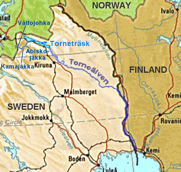
@J. Gouw - Can you also add the other branch of the Torne river because you seem to have only added the Muonio river (this is kind of important since IIRC there were some Russians that wanted to place the boundaries of the Grand Duchy of Finland to the Torne, and ultimately had to settle for the Torne and Muonio):
Alright than i have tried to fix some conflicts in the ibirian but it doesn't get much better... i don't know wat to do with the regions i had to remove result is chaos, i had to modify the tajo river (and replaced it to north) and even then it didn't looks good, it remains a valley north of the tajo that doesn't exists, while the ebro and the pyrenees are better.....
Before ---------------------- After ------------------------
 |
|

Before ---------------------- After ------------------------
Gian
Banned
Alright than i have tried to fix some conflicts in the ibirian but it doesn't get much better... i don't know wat to do with the regions i had to remove result is chaos, i had to modify the tajo river (and replaced it to north) and even then it didn't looks good, it remains a valley north of the tajo that doesn't exists, while the ebro and the pyrenees are better.....
Before ---------------------- After ------------------------
|
What about my request for the other branch of the Torne? It's also important too.
TORNE!!!!!
Ok, so here I have the Torne patch!! LET'S PARTY TILL THE NIGHT ENDS!!
No, seriously, it'll probably be wrong, as I've drawed it freehanded, but I think it'll do by now. Please, point out any mistake you notice

Ok, so here I have the Torne patch!! LET'S PARTY TILL THE NIGHT ENDS!!
No, seriously, it'll probably be wrong, as I've drawed it freehanded, but I think it'll do by now. Please, point out any mistake you notice
I'd give it a try this evening. I already tweaked Garonne and Rhône (tough I suspect Alps and Massif Central are a bit off as well, but it's hard to say giving I use metric-based maps, so with different coloured points) and try Loire and Spain then.Alright than i have tried to fix some conflicts in the ibirian but it doesn't get much better...
Gian
Banned
Ok, so here I have the Torne patch!! LET'S PARTY TILL THE NIGHT ENDS!!
No, seriously, it'll probably be wrong, as I've drawed it freehanded, but I think it'll do by now. Please, point out any mistake you notice
fine then i guess this is it....

Thanks!filler
Oh my Goodness...
I've been rethinking of re-starting my old colour scheme project with updated Q-Bams...but holy moley you guys have been at it!
Do you guys think you can get to a point where you can agree that no more revisions are needing to be made? What about superimposing various Q-Bams together? Like a blank political one over the geographic one you're working on now?
You could start ones for religions and other factors, too, while you're at it
Stormcrow
Share: