Standardized map-making on AH.com, while having progressed significantly both in quality and representation since peoples began to draw and use them, are still generally mixing accurate, not that accurate, obsolete or outright imaginary components.
For various reasons, people involved in RCS/aRCS maps ceased to work on it, and people with different ideas on representation took over, which is certainly opening interesting possibilities.
Still, it appears that a bit of the work, and sometimes high quality work, had been ignored either by taking relatively obsolete basemaps, or by putting strange additions : the core idea of aRCS/RCS model does have merit that could be still helpful for most, being compatible enough with most working color scheme. I think it would be a good idea giving the old girl a ride (possibly on new other boards as well, but that's another matter altogether)
@Alex Richards , @Lord Hastur of Carcosa,@Pressedflowers are probably the ones I can distinctly remember having been either been importantly involved, either being interested, so they might correct me on this.
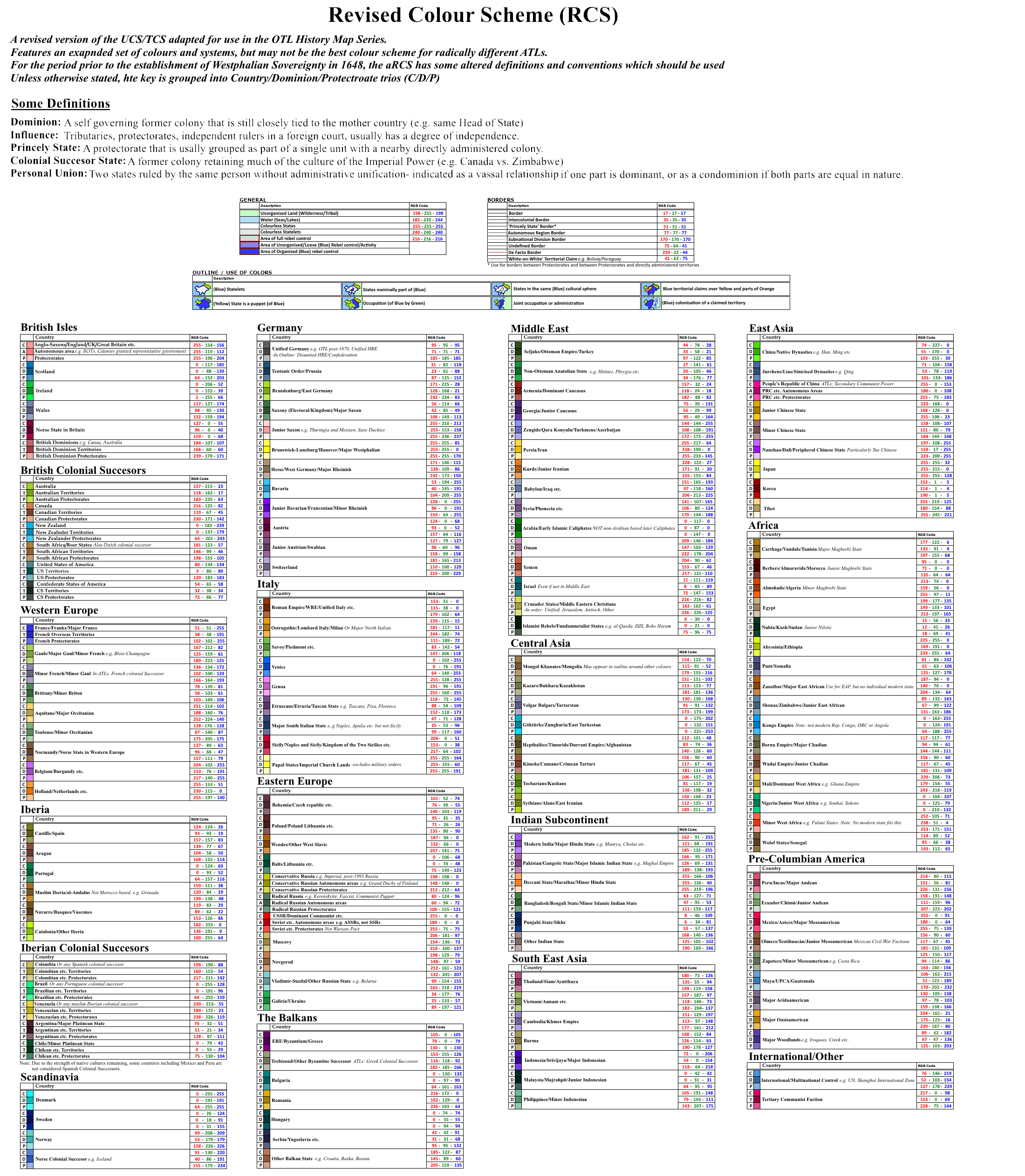
What's aRCS/RCS as a model?
The Revised Color Scheme is essentially the direct continuation of first efforts on this board, from @Thande notably to provide with a standardized depiction of countries that would be both easy enough to be understood without label, and complex enough to provide with some geopolitical representation.
It grew out more complex (sometimes maybe a bit too much) from these roots but essentially kept key principles
Thanks to colored/white lines (to provide with claims, suzerainty, nuances of domination), borders colors and shades (Autonomy/Influence) standardized use, one can make the difference between a protectorate, a client state, a technically independent state under foreign influence, or even a nominal client state puppetized in facts.
It doesn't prevents allohistorical or parahistorical maps or patches to be used, for example in war goals mapping, but is generally set both in colors and representation, on historical grounds.
The point is not to colour or represent everything : but everything relevant as much as possible.
False problems.
[XXX] isn't colored with its traditional colorThere's only this much color available, with a stress of preventing too many geographically close entities to have too much similar colors making that at some point, we get what we can get, with an awful lot of recycling (such as Australia green being used for Mercia).
What are its actual limitations?
Giving the model focuses on historicity, it doesn't fares well on allohistorical timelines that are too removed from OTL. TACOS, among other color schemes, is significantly better at providing something that fills the gap between historicity and allohistoricity.
Depicting colonial territories is a long acknowledged issue : they're clearly treated not the same as the metropolitan territory but how to represent it? Some color schemes tries to use another shade besides Autonomy/Influence, but it's at the expense of clarity and, eventually, not really used.
Its geopolitical-centered nature prevents to really represent transnational, non-states entities : communists and jihadist revolts/takeover/etc are generally using countries colors which adds to the confusion (is a jihadist attack in Afghanistan made by Talibans is the same than ISIS "Caliphate"? I think we can agree it's not).
Similarly, depiction of political difference between, say "Democratic"/"Radical"/"Authoritarian" is more about recycling colors in relevant cases (such as Aquitanian Yellow for Vichy France) than a focus on political representation (and, might be considered discontinued for some exemples, such as Spain IMO).
What's the difference between aRCS/RCS?
A former limitation was that RCS mostly dealt with states as understood nowadays, coming from general acceptance of Westphalian Sovereignity. It didn't prevented people to draw ancient and medieval maps nevertheless, but it lacked in precision as a disunited kingdom as XIth France could be represented the same than an unified states as Ming China.
Similarily, tribal states could be fairly ignored in Eastern Europe, while comparable entities were depicted the same way than Western European statelets.
While RCS got more sophisticated with time, certain changes were necessary to avoid confusion, too much colors involved, and general accuracy.
The aRCS (for ancient Revised Color Scheme) functions as a largely compatible variant with RCS, but that includes suzerainty at the expense of claims, re-used colors (Australian Green is used for Mercia) and use of "statelets" depiction for recorded/likely chiefdoms and early states (such as West Slaves in the IXth century).
For various reasons, people involved in RCS/aRCS maps ceased to work on it, and people with different ideas on representation took over, which is certainly opening interesting possibilities.
Still, it appears that a bit of the work, and sometimes high quality work, had been ignored either by taking relatively obsolete basemaps, or by putting strange additions : the core idea of aRCS/RCS model does have merit that could be still helpful for most, being compatible enough with most working color scheme. I think it would be a good idea giving the old girl a ride (possibly on new other boards as well, but that's another matter altogether)
@Alex Richards , @Lord Hastur of Carcosa,@Pressedflowers are probably the ones I can distinctly remember having been either been importantly involved, either being interested, so they might correct me on this.
What's aRCS/RCS as a model?
The Revised Color Scheme is essentially the direct continuation of first efforts on this board, from @Thande notably to provide with a standardized depiction of countries that would be both easy enough to be understood without label, and complex enough to provide with some geopolitical representation.
It grew out more complex (sometimes maybe a bit too much) from these roots but essentially kept key principles
Geopolitics
At some point, the relations between states/quasi-states are involving degrees of authority over territories, inside or outside one state.Thanks to colored/white lines (to provide with claims, suzerainty, nuances of domination), borders colors and shades (Autonomy/Influence) standardized use, one can make the difference between a protectorate, a client state, a technically independent state under foreign influence, or even a nominal client state puppetized in facts.
Historicity
Choice of colors, focuses and general representations are tied to historical realities : meaning that the choice is guided not by genuine interest, or unhistorical possibilities, but by what existed as prime (while not the only one) interest.It doesn't prevents allohistorical or parahistorical maps or patches to be used, for example in war goals mapping, but is generally set both in colors and representation, on historical grounds.
The point is not to colour or represent everything : but everything relevant as much as possible.
Consensus
Consensus is a great part of the color scheme : while @Alex Richards was generally the most involved in keeping trace of the colors and main settings, aRCS/RCS is essentially a collaborative work whom anyone can participate to its elaboration.False problems.
Not enough colors for Africa makes it a lazy/euro-centrist/racist color scheme.
IOTL was largely dominated by European countries, since the discoveries of America at earliest, at the latest with the XVIIIth century. While there's a lot of under-looked historical regions that deserves a focus (and, in all modesty, people involved generally were the first to address it, just ask @Alex Richards with his map of late XIXth Africa)[XXX] isn't colored with its traditional color
[XXX] should have its own color!
It's sometimes true, and there was a fair trend of representation in the latest updates of aRCS/RCS (notably for Americas). But a color is essentially a marker of geopolitical importance, generally because the concerned polity is suzerain/influencing/have significant autonomies/etc. There's some exceptions with particularly relevant entities receiving colors, but even that tends to come either out of recycling (such as Greece) or out of habit (and these tends to be removed more than the contrary).What are its actual limitations?
Giving the model focuses on historicity, it doesn't fares well on allohistorical timelines that are too removed from OTL. TACOS, among other color schemes, is significantly better at providing something that fills the gap between historicity and allohistoricity.
Depicting colonial territories is a long acknowledged issue : they're clearly treated not the same as the metropolitan territory but how to represent it? Some color schemes tries to use another shade besides Autonomy/Influence, but it's at the expense of clarity and, eventually, not really used.
Its geopolitical-centered nature prevents to really represent transnational, non-states entities : communists and jihadist revolts/takeover/etc are generally using countries colors which adds to the confusion (is a jihadist attack in Afghanistan made by Talibans is the same than ISIS "Caliphate"? I think we can agree it's not).
Similarly, depiction of political difference between, say "Democratic"/"Radical"/"Authoritarian" is more about recycling colors in relevant cases (such as Aquitanian Yellow for Vichy France) than a focus on political representation (and, might be considered discontinued for some exemples, such as Spain IMO).
What's the difference between aRCS/RCS?
A former limitation was that RCS mostly dealt with states as understood nowadays, coming from general acceptance of Westphalian Sovereignity. It didn't prevented people to draw ancient and medieval maps nevertheless, but it lacked in precision as a disunited kingdom as XIth France could be represented the same than an unified states as Ming China.
Similarily, tribal states could be fairly ignored in Eastern Europe, while comparable entities were depicted the same way than Western European statelets.
While RCS got more sophisticated with time, certain changes were necessary to avoid confusion, too much colors involved, and general accuracy.
The aRCS (for ancient Revised Color Scheme) functions as a largely compatible variant with RCS, but that includes suzerainty at the expense of claims, re-used colors (Australian Green is used for Mercia) and use of "statelets" depiction for recorded/likely chiefdoms and early states (such as West Slaves in the IXth century).