You are using an out of date browser. It may not display this or other websites correctly.
You should upgrade or use an alternative browser.
You should upgrade or use an alternative browser.
Request Maps/Flags Here
- Thread starter Tom Thumb
- Start date
- Status
- Not open for further replies.
Crazy Boris
Banned
Looking for QBAM internals for the Second Mexican Empire. Only pic I could find was a dead link.
Any requests for a US Wikipedia style EC map?
are you asking or offering ?
I have a question for y'all: what are some names for the capitals of the 5 Haudenosaunee proper tribes? I'm making a map based on no iroquois confederacy, and they're all going to be seperate nations.
For the Seneca, their principal pre-colonial village was Ganondagan reported to contain 150 longhouses. As each longhouse could hold an entire extended family (the clan) this would mean a lot of people.
https://en.wikipedia.org/wiki/Ganondagan_State_Historic_Site
are you asking or offering ?
Sorry for not being clear, I'm offering.
how about Landon v FDR v Long?Sorry for not being clear, I'm offering.
if someone could figure out where the original map for this came from, a person over at the IM subreddit would appreciate it.
Are there maps for planet worldas, and a hollow Earth worlda?

this should do the trick for planet worldas, though I don't quite get what you mean by "hollow worlda", could you elaborate on that or sketch something in MS paint real quick so I know where you're coming from on this?
Starforce
Banned
if someone could figure out where the original map for this came from, a person over at the IM subreddit would appreciate it.
this should do the trick for planet worldas, though I don't quite get what you mean by "hollow worlda", could you elaborate on that or sketch something in MS paint real quick so I know where you're coming from on this?
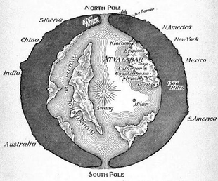
Well, here is what I am talking about.

I'm sorry, I don't think there's any real worldas for that sort of thing, at least not any that I know of. Might be best to make one yourself or get help from someone to put that together. Also, I'm not even sure that sort of thing would actually be fit to go on a map projection in the first place, at least not if you want to show both sides of the world's shell.
I'm sorry, I don't think there's any real worldas for that sort of thing, at least not any that I know of. Might be best to make one yourself or get help from someone to put that together. Also, I'm not even sure that sort of thing would actually be fit to go on a map projection in the first place, at least not if you want to show both sides of the world's shell.
I can't remember which novel it was but in one "hollow earth" story, the geography of the inner world was simply a map of earth with the water and landmasses inverted, something like this:
It was hard to get a clear answer for these considering the destruction of most of the villages/towns during the colonial era, but here are the big towns per nation.I have a question for y'all: what are some names for the capitals of the 5 Haudenosaunee proper tribes? I'm making a map based on no iroquois confederacy, and they're all going to be seperate nations.
- Seneca: Ganondagan, Kanadaseaga
- Cayuga: Goioguen (Cayuga Castle)
- Onondaga: Onondaga (Castle)
- Oneida: Kanonwalohale (Oneida Castle)
- Mohawk: Tiononderoge (Lower Castle), Canajoharie (Upper Castle)
Could anybody help me with figuring out where the mountain ranges go on this map? aditionally, i'd also appreciate it if someone could point out the spots where civilisation might develop.
@B_Munro , could you possibly do this? You did pretty good job on your Through Darkest Europe map.I would like to request a map of 1865 North America with the following alterations:
* Virginia and West Virginia are still together
* a state of Cherokee located in northern Georgia with small bits of Tennessee and North Carolina.* the southern border of Florida stops at the 29th parallel. With the exception of the Florida keys, the rest of the southern peninsula is under the control of Muskogee.View attachment 504887 the state of Cherokee would exclude land from the state of Alabama
*the republic of Texas has it's 1845 borders (including the OTL present day southern border) plus the Mexican state of coahuila.
* The Baja California peninsula is an independent nation (the republic of Baja California)
*Alta California is part of the British Empire (the Dominion of California)
*Mexico still has the state of Nuevo Leon + the Gadsden purchase and the small portion of Nuevo Mexico outside the Texan pan handle.
Thanks in advance.
I would like to request a map of 1865 North America with the following alterations:
* Virginia and West Virginia are still together
* a state of Cherokee located in northern Georgia with small bits of Tennessee and North Carolina.* the southern border of Florida stops at the 29th parallel. With the exception of the Florida keys, the rest of the southern peninsula is under the control of Muskogee.View attachment 504887 the state of Cherokee would exclude land from the state of Alabama
*the republic of Texas has it's 1845 borders (including the OTL present day southern border) plus the Mexican state of coahuila.
* The Baja California peninsula is an independent nation (the republic of Baja California)
*Alta California is part of the British Empire (the Dominion of California)
*Mexico still has the state of Nuevo Leon + the Gadsden purchase and the small portion of Nuevo Mexico outside the Texan pan handle.
Thanks in advance.
Is this about what you had in mind?
It's perfect, thank you!View attachment 505827
Is this about what you had in mind?
I'm really sorry, and I'm just now noticing it, but the lower part of Florida (the portion under the 29th parallel) is independent.View attachment 505827
Is this about what you had in mind?
Again, I'm really sorry, I wish I made that more clear at the beginning.

- Status
- Not open for further replies.
Share: