You are using an out of date browser. It may not display this or other websites correctly.
You should upgrade or use an alternative browser.
You should upgrade or use an alternative browser.
Rememberences of Map Contests Past
- Thread starter B_Munro
- Start date
Zrew33:
First attempt - I do apologise in advance if I have messed something up
However, This is the Frankish Empire.
POD is that Charlemagne only has a single legitimate heir. This allows for a more solidified Frankish Empire that eventually splinters sometime after only to reforms back into the Empire under similar situations as OTL Holy Roman Empire
Upvoteanthology:
In OTL, King of Alba Lulach was unceremoniously killed and succeeded by
Malcolm III. What if, instead of being murdered, he was captured and exiled
off to sea, without any of the original members of his family? With only a
slightly change of punishment, Lulach and his majorly English crew manage
to hold off on bread crumbs from the ship before landing on the coast of
Ednícarseld (New Home) in early 1060. Getting help from the natives, the
crew of 112 quickly formed a small settlement that was built from the
remains of their former vessel. Presenting themselves as peaceful helpers,
the people who lived on the coasts of OTL South Carolina helped and gave
aid whenever the British needed it. Before long, the settlement stabilized
itself. Even if it did lose contact with its former home, it was better than
Lulach ever expected to do. Most of the countries in Europe refused to accept
his refuge for seemingly baseless reasons, and the fact that he was sent with
no navigational equipment made it even more difficult. By the time of
Lulach’s death of old age in 1089, the population of “Lulachfrýgyld” (Lulach’s
Heaven) had already grown to nearly 190. However, the fact that there were
already two settlements by this time made it hard to govern. The two sons of
Lulach, Ælfgar and Lalor, fought over ownership of these towns, eventually
dividing the land up amongst themselves into two separate feudal systems.
They were named “Ælfgaríce” (Ælfgar’s Kingdom) and “Laloríce” (Lalor’s
Kingdom).
Ælfgaríce immediately had the larger amount of power, due to 70% of the
Englishmen living in the region. A population boom supposedly happened
around this time, probably instituted by Lalor to bring the amount of citizens
up. Throughout the twelfth century, various more towns were founded and
many more declared self-rule due to the distance of travel. The two original
kingdoms became one of many within a few more decades, all somewhat
unified under the name of Lulachfrýgyld. The House of Alpin stayed in power
for many years in the formative region, while other cadet braces continued
reign in the north. Some of the natives formed English-influenced states as
well, such as the Cætaba people. These new states gained a lot of power,
influencing the government and language of Frýgian culture. However, the
nations themselves remained purely English in name, due to old tradition. By
the end of the century, places were being named not after the people who
founded it, but after things like famous saints and figures of Christianity. The
religion had taken over Lulachfrýgyld, pushing out the various formed of
paganism for more of a native-influenced type.
The thirteenth century saw a major boom of exploration, with ship technology
taking a massive step forward. The resources of Ednícarseld provided good
for easy expansion, allowing settlement on the peninsula of Edscóníeg
(Florida) and a few minor trade posts on the Walganus River (Mississippi).
Influence on the natives this far in took effect, as the diseases had effected
them nearly a century before. Confederations of tribes began to form,
influenced by the language and 36-letter alphabet of Lulachfrýgyld. By 1300,
settlement took control, with farmland being sought out more than influence.
By this time, the kingdoms began to elect a presiding leader, to loosely rule
over the Frýgian realms. By 1450, the realms of Lulachfrýgyld were
expansive and wealthy, trading as far inland as OTL Utah. The population
grew at around a rate of 1.7% the entire time, meaning that the population
was nearly 77,000 citizens strong. Lulachfrýgyld was becoming centralized
and strong, but what will happen when the Scottish sailors come from the
east?
Njordr:
Following the defeat of the Ottomans at Belgrade, Serbia became a major power in the Balkans. However, this could not last forever - in 1680, groups of cities in Greece and Montenegro banded together to form the Balkan League. This league prospered, and stood in direct competition with the Venetians most of the time.
In 1880, to commemorate the Balkan League's independence, the British Society of Friends for the Balkans had this map made of the contemporary Balkans.
Not all is as peaceful as it seems. Wallachia and Moldavia are vying for control of all of Romania, Dobruja is starting motions for independence, and the issue of South Albania could explode at any moment...
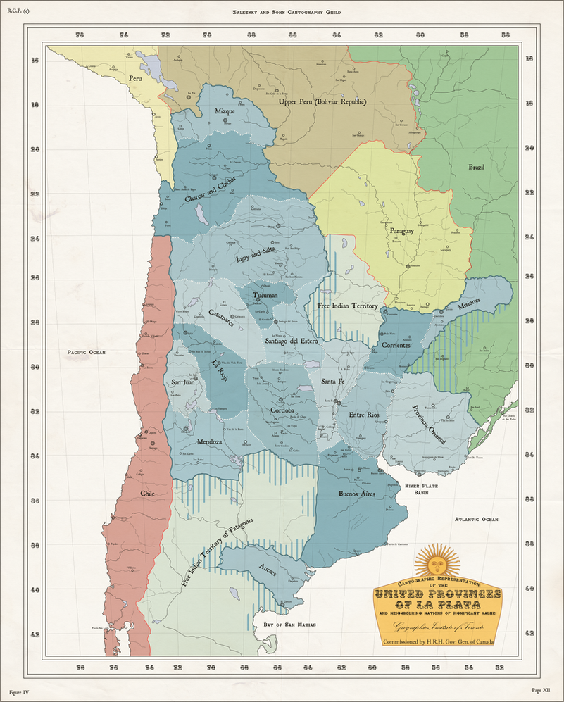
Zalezsky:
The United Provinces of South America (Spanish: Provincias Unidas de Sudamérica) was the original name of the state that emerged from the May Revolution and the early developments of the Argentine War of Independence.
Soon after independence the new nation found itself in a civil war; with Federals, Unitarians, and Separatists all vying for power. from 1810-1825 the civil war raged on.
Finally after many attempts by foreign powers and neighbours to intervene a Union of Provinces was created
with separate constitutions for each state; only bound by a council of elected officials from each state to represent themselves before the Parliament of Provinces.
The Union is a loose confederation of La Platan states, acting more as an alliance than a single nation. Currency appears to be the only binding factor of the provinces. Animosity between former enemy provinces still runs high.
Emperor RyRy:
The Pretanic Isles, the day of the Landing of Ard Rí Riley "The Bane of the Britons" Sluaghadhán, January 9th, 541 CE
I: An Ard-Ríogacht na Ériu. When Róimh (Rome) abandoned the province of Britannia in 235 CE, the former tribes had really no idea what to do. They’d been Rómhánach (Roman) for only seventy years but already they had forgotten how to become Briton again, or, at least, mostly. They turned into somewhat Rómhánach somewhat Briton tiny kingdoms that were constantly warring. The Irish used their expert shipbuilding technology (which defended their coasts against Rómhánach galleys in the last century) to build large fleets that would raid and colonize Pretani. For the next few centuries they would settle families of warriors on the larger island and raid the little statelets. In 431, the year that the Saxons finally broke through the gates of Róimh, the island of Ériu was united under Ard Rí Eamon Sluaghadhán, a man born in the small monastery of Corcaigh who ended his life battling the Ulaidh who rebelled against his rule. His son managed to keep the island together through ruthless suppression of revolting dynasties and the establishment of a (minor) bureaucracy (loosely based on Róimh’s) that would help keep Rí in check and ensure that people were being taxed for labor. Over the next century the island developed and grew in population, took over Dumnonii (which was, by now, mostly Gaelic), Demetia, Gwynedd, and Dál Riata, and connected to the Mediterranean trade network. By 530, when Riley Sluaghadhán came to power, the island was stable and powerful, while the still-warring statelets of Pretani and their ever-changing borders were too irresistible to not conquer! So Riley loaded a fleet of strongboats and currachs, along with thousands of men (plus reinforcements from Ériu after the initial landing), and proceeded to conquer anyone who wasn’t Irish.
II: Guendol, a small and recently depopulated kingdom that is governed by a tribal council.
III: Taken over soon after Ériu unification in order to control the tin trade from Pretani. Also allows Ériu to trade heavily with Gallia.
IV: Glywyssing, another tiny Welsh state that regularly gives tribute to the Ériu in exchange for not being raided.
V: Pengwern, in a similar situation to Glywyssing
VI: Powys, in a similar situation to Glywyssing
VII: Ebruac, rather powerful compared to the rest of the Pretanic Britons, was hardly touched during Rómhánach occupation, still mostly tribal.
VIII: Elmet, always warring the Ebrauc… supposedly for dominance and the right to own the letter “E”.
IX: Cynwidion, looks big on a map but still hasn’t fully recovered from the Rómhánach raping in the 230.
X: Carlerion, little to say, lots of Gearmáinis (German) raiders but has fought off most real attacks.
XI: Cwent, again, subject to Gearmáinis raids.
XII: Colun, a meh tribe.
XIII: Lundien, owns Londinium, and this makes it relatively powerful, but still a meh tribe.
XIV: The Baddan are interesting, because they have been caught between the Irish and hostile non-Gaelic/Briton tribes and have turned into a sort of fortress. Hillforts made of concrete dot their landscape, and every man gets some sort of training. Still, their tiny population made them no match for Riley.
XV: Gwinttic has substantial trade with the Gauls and Gearmánaigh (Germans).
XVI: Ceint is closest to Gallia, and has lots of good trade relations with them and the Hispanians, but is regularly raided by the Angles and Jutes.
XVII: The Glasstening were one of the first on Riley’s list of targets. Relatively fertile, and incredibly depopulated through a recent famine, they gave little resistance and were unable to stop Gaels from coming and colonizing.
XVIII: Bernaccia is a nice place. Relatively powerful, or at least enough so to ensure their people are safe, and a bit far from Danmhairg so they aren’t raided too often.
XIX: Rheged… Huh. Likely going to be conquered by Riley soon, but, as they’re already mostly Gaelic from centuries of colonization, that shouldn’t be too much of a problem...
XX: Alt Clut is a sparse region of semi-nomadic tribesmen. They trade heavily with the Ériu and their rugged terrain makes them not very welcoming to invaders.
XXI: Cat is effectively a vassal of Ériu, having been thoroughly Gaelicized during the 3rd Century, and is basically an extension of Dál Riata.
XXII: Ce is isolated from much of the world. They trade with the Fib and Fidach but nobody else really.
XXIII: The Fib Tribe mostly mind their own business, they’re big on a map but nobody really bothers them.
XXIV: Fotla actually does trade rather extensively with Ériu.
XXV: Fortriu is just there...
XXVI: The Fidach are usually at war with Cat and Fotla, always sending their blue painted warriors into battle and coming home with little but good stories about how they almost sacked that village or this trading post.
MoralisticCommunist:
Sorry I'm so late entering into the contest, hope this still counts.
Anyway, this is a map of the Shogunate of Nihon in 1739. Ever since the 1300s when Nanboku-cho war left the country split in half between the northern and southern Imperial courts, the unity of Nihon has gone downhill. Split between a puppet emperor firmly under the control of the Ashikaga Shogunate in Kyoto and a nationalist and xenophobic emperor in Yoshino, the country basically became two separate entities, despite the Shogun "ruling" over both emperors. As time went on, both sides became more and more feudal, with the Zen School of Buddhism in the North gaining vast swaths of territory thanks to Ashikaga patronage. Then in the 1500s the rise of the radical Ikko-shu sect and their peasant revolts resulted in their resettlement in Hokkaido as the Autonomous Ikko Republic. To this day the nation is plagued by frequent civil wars itself as everyone disagrees over the tiniest bits of policy and religious dogma. Then another autonomous region was established to the south, with the subjugation of the Kingdom of Ryukyu in the early 1600s. Finally, the last autonomous region was established in the mid 1600s, with the Archbishopric of Nagasaki being formed as a home for the new "Kirishitan Catholics." However, over time Kirishitan Catholicism has grown and grown in popularity among the lower classes tiring under the rule of brutal daimyos and autocratic emperors. Eventually, many daimyos themselves began to convert to the new religion as well, leaving the religion a dominant force in Southern Nihon. Thus, the xenophobic Yoshino Emperor, fearful of the growing influence of Christ's teachings declared Nihon closed off to all foreigners, and Kirishitan Catholics in particular. Thus the stage was set for the Sakoku War to begin, as the Emperor as his fanatical Shinto daimyos marched off against the Kirishitan daimyos, in an ill-fated and poorly thought out move that ultimately only served to further Christianity's spread throughout the Shogunate of Nihon.
https://www.deviantart.com/moralisticcommunist/art/C-E-I-O-U-Shogunate-of-Nihon-566861316
(Click on link: I seem to be having trouble getting the map to display here)
Last edited:
MOTF 127: This Too Shall Pass
The Challenge
Make a map showing a region during two different periods - one a golden age of progress and power, the other a dark age of regression and chaos.
The Restrictions
There are no restrictions on when your PoD or map may be set. Fantasy, sci-fi, and future maps are allowed, but blatantly implausible (ASB) maps are not.
The order of the two periods - the golden age and the dark age - is up to you; either may come first, and they can be as far apart as you want.
You may make several maps showing the region at different points in history, or attempt to show the different periods in one map.
 Full version right
Minnesota_Nationalist:
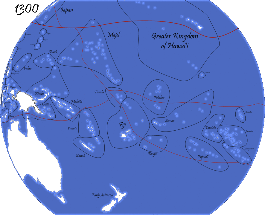
The Empire of Fiji has it's starts in 900 AD when Polynesians first arrived to the island, but it's true rise started in the 1200's when the East Asian States start trading East to the Americas. The Pacific states were able to secure the trade routes and sapped off the trade. The original major powers by 1300 were Hawaii, the Majel State, Kimbe, Samoa, and of course Fiji. But as the trade routes shifts, states grew and shrunk. By 1350, the two great powers of the region were the Majel and Fiji, with Tupuai, Kiriwini, Palau, and Kirimiti as secondaries, but by 1400, it was undeniable that Fiji was the great power of the Pacific and by 1600 had near absolute control of the Pacific.
This was Fiji at their height. Any foreign ship that tried to cross Fijian waters would either be taxed or attacked: an absolute monopoly on Pacific trade. On top of this, they also sported the largest fleet in the world (granted, it was mostly the equivalent of galleys), and their merchants even sometimes went as far as the Swahili Coast to the Incan Coast. They were everywhere.
But when the European entered the scene, they weren't very happy with having to be taxed by heathens and uncivilized men, and so in 1617 Spain started the first Pacific War. While Fiji had the larger fleet in pure numbers, Spain had the more advanced navy. In the battle of the Arino Islands, 5 Spanish ships sunk an estimated 35 Fijian ships while losing only one of their own. In the peace treaty, Spain gained Palau and the North-western Cook Islands, and Fiji had to let Spanish Ships freely cross the Pacific. One by one, other nations came to pick on Fiji: Netherlands, Britain and France all forced Fiji to end their embargoes on them, and as this went on, they either scraped off the Fijian Empire or crumbled on its own, with Australia, New Zealand, Hawaii, Kimbe-Kiriwini, Mariana, and it's old nemesis of the Majel.
But this wasn't quite the end of the Fijian Empire, for 3 very important factors all came to play that allowed Fiji to rise again, for however brief.
1: Between 1768-1779, the Fijian Emperor made wide and large reforms that included the Fijian navy from terrible to about on par with the Europeans and tax reforms
2: A National enthusiasm to aid their dying nation, which included sailors who were willing to be paid essentially a bare minimum wage.
3: Europe was at war with itself
And so, in 1799, Fiji launched a massive invasion of surrounding European possessions. Sometimes, they were just given to them or were unprotected because of how unimportant they were. This was the Fijian Renaissance, a 20 year period that saw wealth and trade return to the island of Fiji.
Sadly, this was not to last, as when the great European Wars ended, so did the Fijian Renaissance, and in 1818, Britain returned to reclaim her possessions, as did France and the Netherlands (Spain was a bit occupied with her colonies). The last of the Pacific wars raged, with dozens of ships sinking on each side, islands captured and recaptured, entire islands burned. Finally, in 1825, Fiji was forced to surrender, and was forced to go down to her former islands and then some. For years after, Fiji was just a puppet tossed around and played with by the great powers, every once and a while a slice would be taken at the expense of the one once great Fijian Empire.
DeviantART-AltHistoria
Njordr:
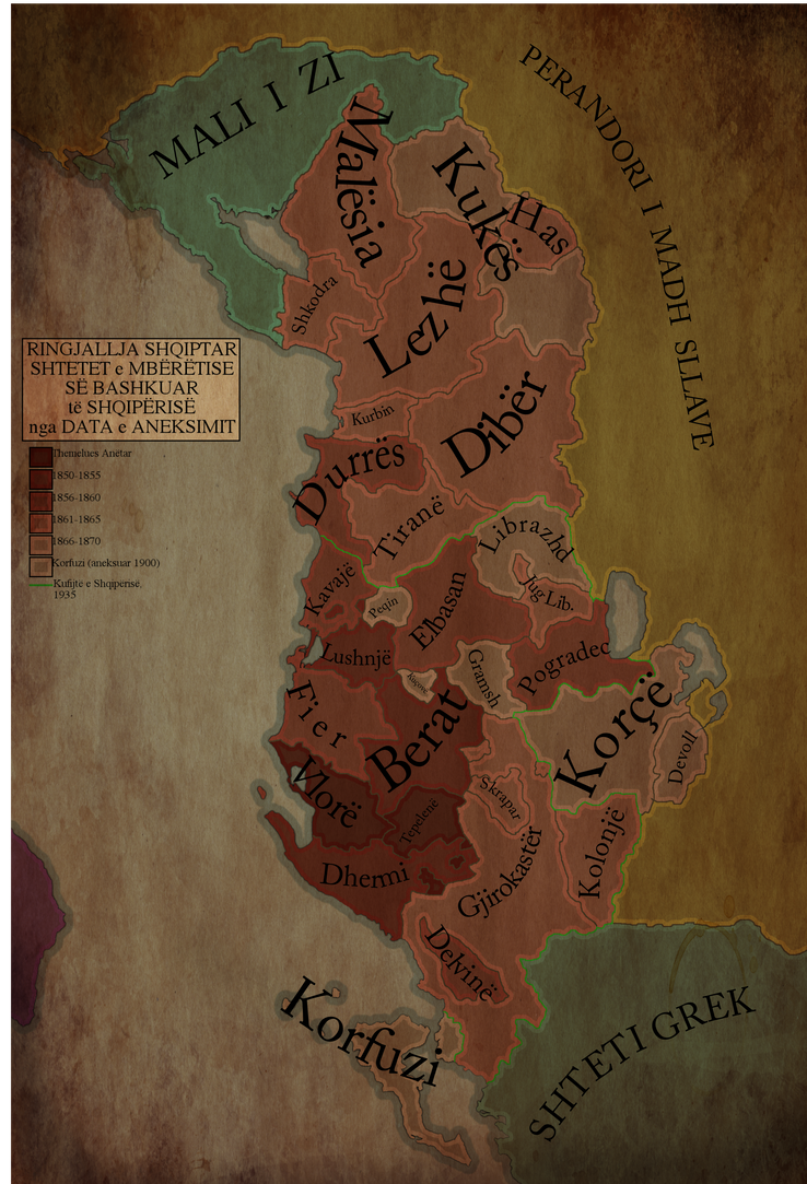
From the description:
"Following the collapse of the Second League of Lezhë in 1500 AA (corresponding to roughly 3400 AD) at the hands of the Great Slavic Empire, The various minor Shqipërë states would remain in a set of minor city-states and remnants of the old concept of "Albania". This changed in 1849/3749, when the city-states of Vlorë and Tepelenë united into the United Kingdom of Albania. This state would then slowly expand to fill in all of Old Albania, and by 1900/3800 Corfu would be annexed.
35 years later, The UKA was destroyed by the Great Slavic Empire, and severely reduced. Although the old capital of Vlorë still lies within her territory, all lands of historical significance to the UKA have been lost.
Steampunk/Dieselpunk/Nondescript apocalypse is a wonderful thing. "
Showing the various Shqipërë states at the time, colored by date of annexation into the UKA, with a green border outlining the result of Great Slavic intervention into Albanian matters.
shiftygiant:
~The United Commonwealth of Poland~
Map of the UCP at its height (1927-1960) superimposed on modern borders. Modern Poland is in Red.
The United Commonwealth of Poland, also known as the Second Commonwealth, or simply Poland, refers to the nation that existed between the Wars of Polish Reunification and the Second Partition (1924-1967). Founded in the initial aftermath of the First World War under the Wilson Agreement in 1918, following a series of intense regional conflicts, the planned borders far outgrew the original plan of the Polish Committee, expanding from Gdynia to Ryga to Odessa, the final borders decided following the Polish-Soviet War in 1927. Surrounded by Germany, Czechoslovakia, Austria (Until 1940), Rumania, The Soviet Union, The Kingdom of Königsberg (From 1942), and the Baltic Union (Until 1938), Poland saw a turbulent relationship with her neighbors, switching between alliances and antagonism, often alienating the state from the rest of Eastern Europe; from the end of the Polish-Soviet War to the Second Polish-Soviet War (1960), the UCP controlled a corridor of land that connected the state to the Black Sea. Despite ethnic tensions from it's diverse Ethno-Linguistic makeup, and pressures internal and external, the UCP was able to remain a dominant regional power for most her existence, often refereed to as the 'Second Golden Age' due to it's relative political and economic stability and technological progress. This would end with the Second Polish-Soviet War, which cut Poland from the Black Sea and crippled her accompany, and saw a fragmentation of Commonwealth society, accumulating in the Second Partition in 1967 by the League of Nations.
The UCP has been often refereed to as Switzerland of Eastern Europe- this grew from it's twenty-nine year long period of Armed Neutrality (1930-1959)*, as well as long lasting President Milo Jakubowicz's (1880-1956) emphasis on Banking, Trade, Social Democracy, and Public Works, hoping to make Poland the most modern state in Europe. Whilst it is generally agreed that this was, in a sense, accomplished, this came with disenfranchisement of Ukrainian, Byelorussian, and Russian minorities, as well as the controversial Language Laws, both often cited as the reason for the Commonwealths failure. The UCP was succeeded by the Third Polish Republic, with it's Eastern Frontier carved up between the Soviet Union and Königsberg. Today, the legacy of the UCP is physically visible, with it's roads and cities held as marvels of 20th Century Engineering, and a strong Polish Language Presence.
Since 1967, Poland has been in a state of constant Political flux, with the rise of the Far Right organisation Narodowe Odrodzenie (National Revival) through 70's and 80's, leading mass violence against ethnic minorities and homosexuals, as well as rioting against Liberal legislation, NO seeing ethnic diversity, the acceptance of Homosexual lifestyles, and general Liberalism as the causes for Poland's second partition. NO would gain ground in the Polish Elections, with their leader Alex Gmurczyk ascending to high office briefly in the Summer Election of 1988 after running an vigorous Anti-Communist, however would be removed by the Polish Army following his attempt to pass anti-Minority legislation. The Army, led by Wojciech Jaruzelski, took control of the nation, instituting Martial Law and banning Political Parties; this would result in the Polish Civil War, which saw the Army, NO, and Communists fight for domination. Following the dissolution of the Soviet Union in 1995, Germany and Czechoslovakia would lead a League of Nations intervention into Poland, annexing western regions in the process. With the League of Nations taking control of the nation, Poland was transitioned back into Democracy, however still suffers from Strong Man politics, high levels of Corruption, and rampant violence against minorities and homosexuals. Since 2006, Poland has been part of the Commonwealth League, however due to antagonism to Königsberg and Ukraine, has seen its membership threatened.
The UCP was a founding member of the ECC, with the Third Republic a having been a member of the ECC's successor, the European Community, since 1999.
*Also referred to as the Golden Age, it is worth noting that Poland did fight armed conflict during this period, namely in the Anglo/Franco-German War (1938-1943), however was itself third party to the events.
Tardis218:
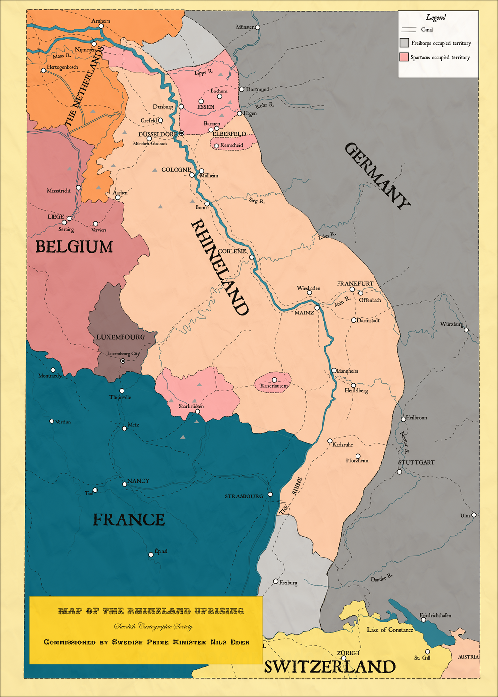
The Great War (1914-1919) left a lasting impact on the world. Empires had fell, territories exchanged, and hell spread throughout Europe. One example is in the Rhineland, previously the industrial heartland of Germany fell in chaos during the The Great War. After the Allied breakthrough in 1918, they soon fell into the hole of trench warfare once again, only this time in the Rhineland. The Allies and Germany alike sent planes to bomb each others trenches, the coal mines were destroyed, villages looted, and finally the Allies manage to push forward and win the war in 1919. During the Peace Conferences the Rhineland managed to gain independence after the French delegation managed to convince the other delegations. The economy of the Rhineland was horrid, and several months after independence loans were taken from the Americans. There was worse on the horizon. Communist rebels in 1919 rose up, after inspired by the events in Berlin and Russia, they largely rose up in the industrial cities, officially establishing control in the factories. The army of the Rhineland responded with patrolling the nation, but gorilla fighters attacked the forces, killing many. A few months later the Freikorps came into the nation, attacking the communists. The Rhineland government had no say on them coming in, and several incidents of attacks between the army and the Freikorps occurred, making them hostile to each other. With the army it terrible condition, and enemies all around them the Rhineland government called upon the Allies to send their own forces, they have responded with meetings in Paris, London, and Brussels, and finally, with men.
(I forgot to include- the grey triangles represent coal fields)
(And the dashes that are going everywhere are train tracks)

The Rhineland in it's golden age, when it was a province of the Kaiserreich.
The Great War (1914-1919) left a lasting impact on the world. Empires had fell, territories exchanged, and hell spread throughout Europe. One example is in the Rhineland, previously the industrial heartland of Germany fell in chaos during the The Great War. After the Allied breakthrough in 1918, they soon fell into the hole of trench warfare once again, only this time in the Rhineland. The Allies and Germany alike sent planes to bomb each others trenches, the coal mines were destroyed, villages looted, and finally the Allies manage to push forward and win the war in 1919. During the Peace Conferences the Rhineland managed to gain independence after the French delegation managed to convince the other delegations. The economy of the Rhineland was horrid, and several months after independence loans were taken from the Americans. There was worse on the horizon. Communist rebels in 1919 rose up, after inspired by the events in Berlin and Russia, they largely rose up in the industrial cities, officially establishing control in the factories. The army of the Rhineland responded with patrolling the nation, but gorilla fighters attacked the forces, killing many. A few months later the Freikorps came into the nation, attacking the communists. The Rhineland government had no say on them coming in, and several incidents of attacks between the army and the Freikorps occurred, making them hostile to each other. With the army it terrible condition, and enemies all around them the Rhineland government called upon the Allies to send their own forces, they have responded with meetings in Paris, London, and Brussels, and finally, with men.
(I forgot to include- the grey triangles represent coal fields)
(And the dashes that are going everywhere are train tracks)
The Rhineland in it's golden age, when it was a province of the Kaiserreich.
Zek Sora:
Two Halves of a Sandwich


The Paulet Affair ends a little (or a lot) differently in this world, leading to a Hawaii that is split between a British protectorate Kingdom of Hawaii that is effectively ruled by the resident British Consul and an American Territory of Hawaii. The British created a protectorate over the Kingdom of Hawai'i in 1843, after the conclusion of the Paulet Affair. However, the Americans were angered by the perceived violations of their interests in the new Hawai'ian Protectorate, and by the constant violation of American merchant rights. Since the Americans and British could not agree on either power holding the entirety of the islands, it was finally negotiated that the islands would be split between the two.
The first map shows the Kingdom of Hawai'i as it was immediately pre-Affair, under the rule of King Kamehameha III.
The second map shows the situation in the former Kingdom of Hawai'i (post-Partition) in the Year of our Lord 1903. The two colonies have developed their own unique cultural identities over time, including significant White settlement in some areas, but their economic systems are mostly the same, revolving around a plantation system in which most natives are brutally exploited to grow massive amounts of sugar and other tropical goods. There is significant nationalist sentiment on the islands, and there have been multiple uprisings in the past in both colonies.
The inset shows the city of Kahului, source of the name for the treaty which divided the islands. It was determined in the Treaty of Kahului in 1853 (between the British and U.S. governments) that the city of Kahului would be split between the two powers, to serve as a place for further negotiations to occur if a crisis or any other issue arose.
Two Halves of a Sandwich
The Paulet Affair ends a little (or a lot) differently in this world, leading to a Hawaii that is split between a British protectorate Kingdom of Hawaii that is effectively ruled by the resident British Consul and an American Territory of Hawaii. The British created a protectorate over the Kingdom of Hawai'i in 1843, after the conclusion of the Paulet Affair. However, the Americans were angered by the perceived violations of their interests in the new Hawai'ian Protectorate, and by the constant violation of American merchant rights. Since the Americans and British could not agree on either power holding the entirety of the islands, it was finally negotiated that the islands would be split between the two.
The first map shows the Kingdom of Hawai'i as it was immediately pre-Affair, under the rule of King Kamehameha III.
The second map shows the situation in the former Kingdom of Hawai'i (post-Partition) in the Year of our Lord 1903. The two colonies have developed their own unique cultural identities over time, including significant White settlement in some areas, but their economic systems are mostly the same, revolving around a plantation system in which most natives are brutally exploited to grow massive amounts of sugar and other tropical goods. There is significant nationalist sentiment on the islands, and there have been multiple uprisings in the past in both colonies.
The inset shows the city of Kahului, source of the name for the treaty which divided the islands. It was determined in the Treaty of Kahului in 1853 (between the British and U.S. governments) that the city of Kahului would be split between the two powers, to serve as a place for further negotiations to occur if a crisis or any other issue arose.
Pischinovski:
My MotF entry:
A classic Nazi Victory scenario.
The year is 1979: the most Slavs and Balts are death and the survivors are slaves of the Reich.
The map shows the Gaue of Greater Germany without the Reichskommissariate and the protectorates (State of the Netherlands, State of the North).
Also shown are the capitals of the Gaue and the Deutsche Fernbahn (German long distance railway).
Full sized map: http://fc00.deviantart.net/fs70/f/2013/251/b/9/motf83_by_pischinovski-d6lcsby.png

Number of Germans wouldn't be in 70s so high, Nazis wanted to settle only 5 millions Germans in the east (Białystok-Lithuania, northern Russia, southern Ukraine-Crimea and 36 cities in other areas), due to natural income it had to be 8 millions in next 30 years (70s). "Subhumans" had to be reduced by 51 millions, not over 100 millions and had to be resettled into Brazil, not killed.
Number of Germans wouldn't be in 70s so high, Nazis wanted to settle only 5 millions Germans in the east (Białystok-Lithuania, northern Russia, southern Ukraine-Crimea and 36 cities in other areas), due to natural income it had to be 8 millions in next 30 years (70s). "Subhumans" had to be reduced by 51 millions, not over 100 millions and had to be resettled into Brazil, not killed.
Not my map and scenario; just reposting good stuff from old contests for the benefits of new members (and old members who like having this archived in one place)
Uh...what??"Subhumans" had to be reduced by 51 millions, not over 100 millions and had to be resettled into Brazil, not killed.
Erhard Wetzel, "Reichsführer's comments and suggestions to the General Plan Ost", 27 April, 1942
Full text in German https://ifz-muenchen.de/heftarchiv/1958_3_5_heiber.pdf
Full text in German https://ifz-muenchen.de/heftarchiv/1958_3_5_heiber.pdf
Share: