Huh, wow. That's fascinating.Wikipedia says Abdullah I was crowned King of Jerusalem by the Coptic patriarch. The veracity of that though I know not.
You are using an out of date browser. It may not display this or other websites correctly.
You should upgrade or use an alternative browser.
You should upgrade or use an alternative browser.
Proposals and War Aims That Didn't Happen Map Thread
- Thread starter Beedok
- Start date
Someone on this forum stated that in 1992, some Russian figure(s) proposed that the newly-formed "Russian Federation" should be a federation of the four historical Russian nations: Russia proper (Great Russia), Ukraine (Little Russia), Belarus (White Russia), and Kazakhstan, the latter is not counted as a historical member of the "All-Russian nation" doctrine, but in the modern era, Kazakhstan has a large Russian population and speakers, and is the 'stan that has been the closest to Russia.
The user in question said that Putin of all people was the one who proposed this, but is there a source for this? additionally, have any Russian figures explicitly thought of annexing Kazakhstan in particular? not the generic annexation of all former Soviet/Russian Imperial territories, only Kazakhstan in particular, I thought that most realpolitik-minded Russian Nationalists would pull the same thing they are doing in Ukraine: Incite Russian separatism and only annex the Russian-majority border regions of Kazakhstan instead of the whole country.
The user in question said that Putin of all people was the one who proposed this, but is there a source for this? additionally, have any Russian figures explicitly thought of annexing Kazakhstan in particular? not the generic annexation of all former Soviet/Russian Imperial territories, only Kazakhstan in particular, I thought that most realpolitik-minded Russian Nationalists would pull the same thing they are doing in Ukraine: Incite Russian separatism and only annex the Russian-majority border regions of Kazakhstan instead of the whole country.
Kazakhstan was Slavic majority in 1990sI thought that most realpolitik-minded Russian Nationalists would pull the same thing they are doing in Ukraine: Incite Russian separatism and only annex the Russian-majority border regions of Kazakhstan instead of the whole country.
No it wasn't. In 1989, Kazakhs made up 39.7% of the population, while Russians -- the next-largest group by far -- made up 37.8%. By 1999, Kazakhs were 53.5%, while Russians were 29.9%.Kazakhstan was Slavic majority in 1990s
source
One other consideration in 1992... weren't those the four Republics where all the nukes were stationed?Someone on this forum stated that in 1992, some Russian figure(s) proposed that the newly-formed "Russian Federation" should be a federation of the four historical Russian nations: Russia proper (Great Russia), Ukraine (Little Russia), Belarus (White Russia), and Kazakhstan, the latter is not counted as a historical member of the "All-Russian nation" doctrine, but in the modern era, Kazakhstan has a large Russian population and speakers, and is the 'stan that has been the closest to Russia.
The user in question said that Putin of all people was the one who proposed this, but is there a source for this? additionally, have any Russian figures explicitly thought of annexing Kazakhstan in particular? not the generic annexation of all former Soviet/Russian Imperial territories, only Kazakhstan in particular, I thought that most realpolitik-minded Russian Nationalists would pull the same thing they are doing in Ukraine: Incite Russian separatism and only annex the Russian-majority border regions of Kazakhstan instead of the whole country.
They were indeed.One other consideration in 1992... weren't those the four Republics where all the nukes were stationed?
No it wasn't. In 1989, Kazakhs made up 39.7% of the population, while Russians -- the next-largest group by far -- made up 37.8%. By 1999, Kazakhs were 53.5%, while Russians were 29.9%.
source
Kazakhstan was Slavic majority in 1990s
Think walmart might have been thinking of 1940s into the 1980s when it was plurality Russian. However, walmart is correct that in the early 1990s it was plurality Slavic (not just Russian) in comparison to Kazakhs. Even in 1989 the combined Russian, Ukrainian, Belarusian, and Polish population (the Slavic population) was 44.7% of the population (of which East Slavs were the overwhelming majority as by themselves they were 44.3% of the total population) .
However it was still plurality Turkic where the combined Kazakh, Uzbek, Uyghur, Tatar, Turk, Azeri, and Kyrgyz population was 45.7% of the total population.
Wikipedia claims to a Coptic Bishop crowned the Jordanian King as King of Jerusalem, though I do wonder what title was used, as Emirs, Tribal Leaders, a Khedive, and possibly a Sultan took the title of King in the 1900’s. I suppose the title of Emir seemed subservient to a Caliph, Sultan would get the Ottomans in their case (or was seemed too closely tied to the Caliph), and the title of Caliph was sacrilegious to claim. For the King of Jordan to claim both political and religious authority over an area seems to keep with tradition, especially as the Hashemites are probably still smarting from losing the Sharifates of Medina and Mecca.Correct me if I'm wrong, but iirc the King of Jordan claimed the title of Sharif of Jerusalem, not King? It's sort of a similar title, but the Sharif is specifically in charge of protecting Islamic holy sites -- like how before the independence of the Kingdom of the Hejaz, the Hashemites were the Sharifs of Mecca & Medina under the Ottomans. Today, the King of Jordan administers his sharifate over Jerusalem through the Jerusalem Waqf.

King of Jerusalem - Wikipedia
The Junkers will be intriguing to try and stop the Catholics from holding a monopoly of power, this is really going to destabilize the German right (and probably butterfly away the Nazis).Former seems more likely to me.
I don´t think Austria would strenghten german radical left. Aside of "red Vienna" Austria was more conservative I think - actually similar situation to Bavaria.
About nazis - well, Austria being part of Germany seems to me as pretty big butterfly, but if thinks otherwise go similar to OTL, I don´t think this would present rise of nazi popularity - while Anschluss would give more popularity to Weimar system, as long as there is big economic crisis, rise of extremism is inevetable - which doesn´t mean, Hitlers rise to power is! As you said, maybe there is stronger non-nazi right, so Hitler isn´t needed by von Papen or something? (assuming things so far go mostly as OTL, which isn´t sure...)
Foreign politics - I guess that Czechoslovakia will be way, way more nervous. And so become maybe more hostile to its german minority (going as far as creating some more authoritative regime?), and seeking more allies... attempt for better relations with Poland? And/or Italy (which probably isn´t pleased with big Germany instead of tiny, poor Austria on its borders).
Or I can see alternative, with Czechoslovakia trying to cultivate better relations with its western neighbor,* with or against its own german population
* before rise of nazis, czechoslovak-german relations weren´t warm, bu definitely not hostile
Cut it up based on “what ingredients you put in chai.” The Holy Roman Empire would look sane in comparison.Suppose post-colonial India had been organized on cultural rather than religious lines?
Would people take note of the "curry lines", a la the "gefilte fish line" in Eastern Europe?Cut it up based on “what ingredients you put in chai.” The Holy Roman Empire would look sane in comparison.

Crazy Boris
Banned
I don’t have a map for this, but a few days ago found out that there were originally going to be just three occupation zones in Germany, France would be excluded. Charles de Gaulle was just really persistent in demanding that France get one, apparently Stalin said something to FDR and Churchill along the lines of “just give him one so he’ll shut up”
Rhineland-Palatinate was originally going to be in the British Zone, and the parts of Baden-Württemberg France for would have been under American occupation. I’m not certain about Saarland given the special situation it was in after the war, but had the Saar protectorate not been made, I’m guessing it would have been British too.
And on that topic, not a proposal, but something of note, sizable parts of the British and French zones were to be placed under occupation by Belgium, Poland, Luxembourg, and Denmark to assist the occupation forces there, but weren’t given separate zones themselves, but it’s interesting to think about if they were (or for a funny scenario, combine these two ideas, imagine how furious De Gaulle would be if Luxembourg was given a full-on occupation zone and France wasn’t)
Last time I talked about the initial proposals of the Alaska Railroad Commission. This time, I've got something that's - if anything - even more ambitious. In October 1942, the US Army Corps of Engineers carried out a study into the feasibility of constructing a rail link from Canada to Alaska, and potentially beyond Fairbanks to the Seward Peninsula, to meet military requirements.
TRANS-CANADIAN ALASKA RAILROAD
The line would start from Prince George in British Columbia, on the Canadian National Railway. At this time, the Pacific Great Eastern hadn't reached Prince George, much less extended to the north. The Trans-Canadian Alaska Railroad would run from here into the Rocky Mountain Trench; the recommended route was rather to the west of the route actually built as part of OTL's Pacific Great Eastern extension to the Peace River district. The route this took was recognised as a potential alternative option.
The line would then generally follow the western edge of the Rocky Mountain trench, which would now be under Lake Williston, until reaching Chee House. At this point, instead of followinh the Kechika river, the line would strike out north-westwards, crossing the Liard River. THere, the line would head past Watson Lake and broadly follow the line of the Campbell Highway toward Carmacks. An alternative line would leave the Little Salmon River before its junction with the Yukon River, instead heading along the shores of Frenchman Lake and following the Tatchun River to the Yukon.
Thereafter, the Yukon would be followed as far as the White River, following that branch westwards to the Ladue river, then up that valley until the portage froim the Ladue to the Yukon near Tetlin Junction. The Alaska Highway route would then be followed as far as Delta Juncction, before heading westwards across the foothills of the Alaska Range to reach the Alaska Railroad at Kobe Station, in the general area where today's George Parks Highway crosses the Alaska Railroad.
It was envisaged that the Alaskan section of the railroad would be operated by steam locomotives, with a view to retaining it post-war for operation by the Alaska Railroad. The Canadian section, however, would be diesel operated, on the usual grounds of cheap, simple operation. There would be minimal provision for intermediate stations: goods facilities en route would largely be for the benefit of railway operations.
WESTERN DIVISION
A further extension of the line - now titled the Trans-Canadian Alaska and Western Railroad - was considered to a 'deep water terminal' in the Norton Sound area. Seven sites were investigated for this harbour; Port Clarence - north-west of Nome - was identified as the most suitable, with Golovnin as the best alternative.
This line would leave the Alaska Railroad at Dunbar, north of Nenana and west of Fairbanks, crossing the Minto Flats and entering the Yukon watershed, where it would cross the river at Rampart Canyon. There is a passing mention of a 'grandiose scheme' for a dam at this location. The right bank of the Yukon would then be followed to the mouth of the Melotzitna, opposite Ruby, where the railroad would head up the tributary then across a low pass into the Whakatna valley.
This route would take the railroad into the Koyukuk Flats north of Galena, crossing the swampy flats and the river itself to reach Denny Creek - which I can't locate on any map - and into the Nulato valley, following that river south-west before crossing to the Shaktolik river. This loops from northerly, to westerly, to southerly, before reaching Christmas Mountain (no, really) and crrossing to follow the Ungalik River northbound, then following the coast, crossing the Ingulatik and Koyuk rivers westwards.
The Kwiniuk river is used to gain access to Golovin Bay, then following teh Fish and Niukluk rivers northwestwards, passing the settlement of Council, then turning west. In this region, part of the general route of the disused Seward Peninsula Railroad would be followed, though the roadbed itself was thought of little value even to provide construction supplies, before continuing west along the lower slopes fo the Kigluaik Mountains, terminating at the Teller Harbor Development, for which I don't have the report.
Alternative routes were considered earlier in 1942 to reach Port Clarence. The Niukluk might be followed further northwest towards the Kuzitrin Valley, approaching Teller from the east rather than the south. Why this route was dropped, I'm not sure; the first 25 pages of the later report are missing!
A more northerly route to the Koyuk Valley was also possible via the Kateel and Ingulatlik rivers. The Koyuk could then be followed northwesterly and the northern edge of the Bendeleben Mountains followed to reach the Kuzitrin River and then westwards to Teller. This option would be shorter, but could not serve Golovin Bay, and couldn't be surveyed in detail due to poor weather. There's an interesting handwritten note against this route saying "This is the best route by far, except Bering Land Bridge."
Of course, none of these routes came to fruition. It would take at least two years to construct either, by which time the benefit to the war effort would be minimal. And the cost of doing so would be significant: the lines were invariably remote or in difficult country. Usually both. Still, the prospect of connecting Alaska to the rest of the United States by rail is one that continues to be discussed, and even a rail line into the interior hasn't been entirely ruled out. It still comes up occasionally, though more often a road, as a way of improving links within the state and to provide access to mineral deposits.
Wasn't this one a proposed partition of Bengal before the partition?View attachment 811846
Map of Greater Bangladesh, a conspiracy theory floated around in contemporary Indian ultranationalistic circles which claims that modern Bangladesh not only wishes to annex West Bengal in hopes of creating a United Bengal, but also the Seven Sister States due to them having sizable Bengali populations.
What a nightmare for us ,the Georgians and the Middle East. This would be a sadistic joke of destiny for us to be dominated AGAIN at best if not ANNIHILATED. I am not even sure it would be desirable to my Azeri friends.Another day, another dystopian manifesto:
In the year 2009, American strategist George Friedman published the book The Next 100 Years, which is supposedly a set of predictions about the geopolitics of the 21st century. A while ago I read the book and it quickly became clear to me that, while the stuff he says could be seen as mere forecasting, it also kind of sounds like a series of suggestions and plans, with the ultimate goal of crushing Russia, China and other Eastern Bloc nations, and then permanently asserting global dominance by defeating the allies-turned-enemies of Turkey and Japan. For reference, here's a couple interpretations of what his world looks like in 2050, right before the "third world war" which he says would only take half a million lives:
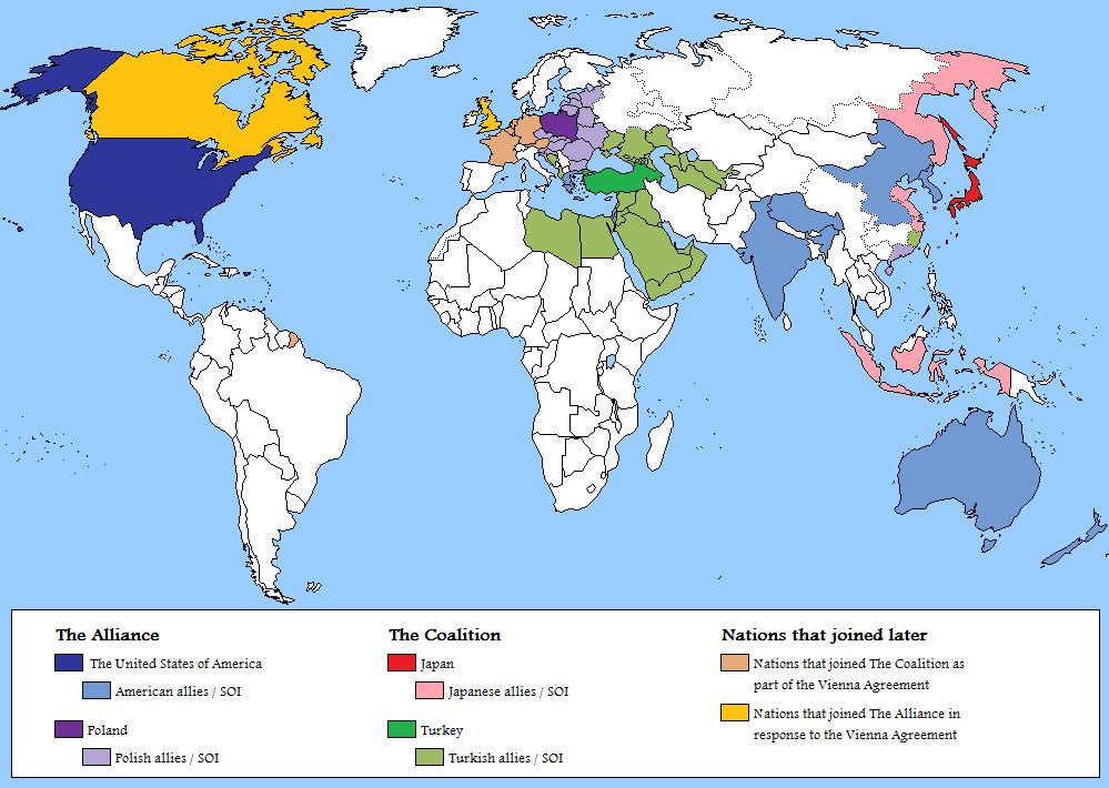
In a way, this kind of seems like the exact reverse of Dugin's Foundations of Geopolitics, displaying a similar end goal except for the opposite side.
In 2007, a group of Native American activists (mostly Sioux) asserted that, since the United States had violated the 1851 Treaty of Fort Laramie, they were within their legal rights to declare independence. The Republic of Lakotah would include all Sioux reservations, including Standing Rock, as well as the Black Hills (including Mt Rushmore/Six Grandfathers). This proposal is controversial among American Indians, however, since it has the approval of no tribal governments or representatives. It is also controversial even amongst more radical Indian activists who might want an independent state, because it was proposed by Russell Means -- a libertarian who proposed that it be organised around free market principles, adhere to the gold standard, and would collect no nationwide taxes. Many American Indian activists (such as those who protested the Dakota Access Pipeline) lean leftist, and advocate for stricter environmental standards, not deregulation. Means seems sort of like a "sovereign citizen" type, tbh, and he has the support of similar movements (like the Alaskan Independence Party and the Second Vermont Republic -- neither of which are Indian, but both of which are libertarian).
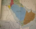
Is there a version where the key is actually readable?Mussolini’s plan for Middle East
Sadly the only version for this one, but i indentified they key: yellow are italian colonies, Oman is a protectorade and the rest are client states.Is there a version where the key is actually readable?
Share: