Plus the fact that Aromanians in Greece tend to be fervently Greek and among the champions of Greek nationalism. And there were many Aromanian Greek politicians to whom such thoughts were anathema. Heck, George Averoff (who sponsored the namesake cruiser) was an Aromanian. The first puppet prime minister of OTL, Tsolakoglou, was himself of Aromanian descent, and he vehemently opposed Italian plans.
You are using an out of date browser. It may not display this or other websites correctly.
You should upgrade or use an alternative browser.
You should upgrade or use an alternative browser.
Proposals and War Aims That Didn't Happen Map Thread
- Thread starter Beedok
- Start date
Fidel Llorente
Banned
I see, sometimes we forget the level of conflict between Italy and Germany.Remember that this is just speculation that I made for my timeline, in real life we have contradictory or vague Axis plans for Greece, as an important example of this, Italy wanted to annex pretty much all Greek islands (Cyclades, Sporades, Aegean, Crete, Ionian), Greece would be reduced to a tiny state with only the Saronic isles and Euboea left, but Germany was against that plan.
In my TL, Germany lets this happen anyway because 1. they are much more preoccupied with Generalplan Ost, 2. they are also busy stopping resistance and partisan movements elsewhere in Europe, and 3. they let Greece be reduced to a tiny weak state as a retribution for its massive rebellion, Italy is also more powerful than IOTL and they are not as incompetent and dependent on Germany as they were IOTL.
What do you mean "East Thrace"? the Northern Aegean coast is only controlled by Bulgaria or Turkey, that is about it.
Italy wouldn't like this however.
When I say East Thrace, i mean that tiny sliver of Greek Thrace which was left under their control as an exclave.
also since it is called the "Principality of the Pindus", who would be its prince? perhaps someone from the Italian Royalty, like how Prince Aimone was crowned as Tomislav II of Croatia (but he later regretted this)?
@Zagan didn't you say somewhere once that one of your ancestors was proposed as the Prince, or am I misremembering?
Hope I'm not stretching the thread topic too much but:

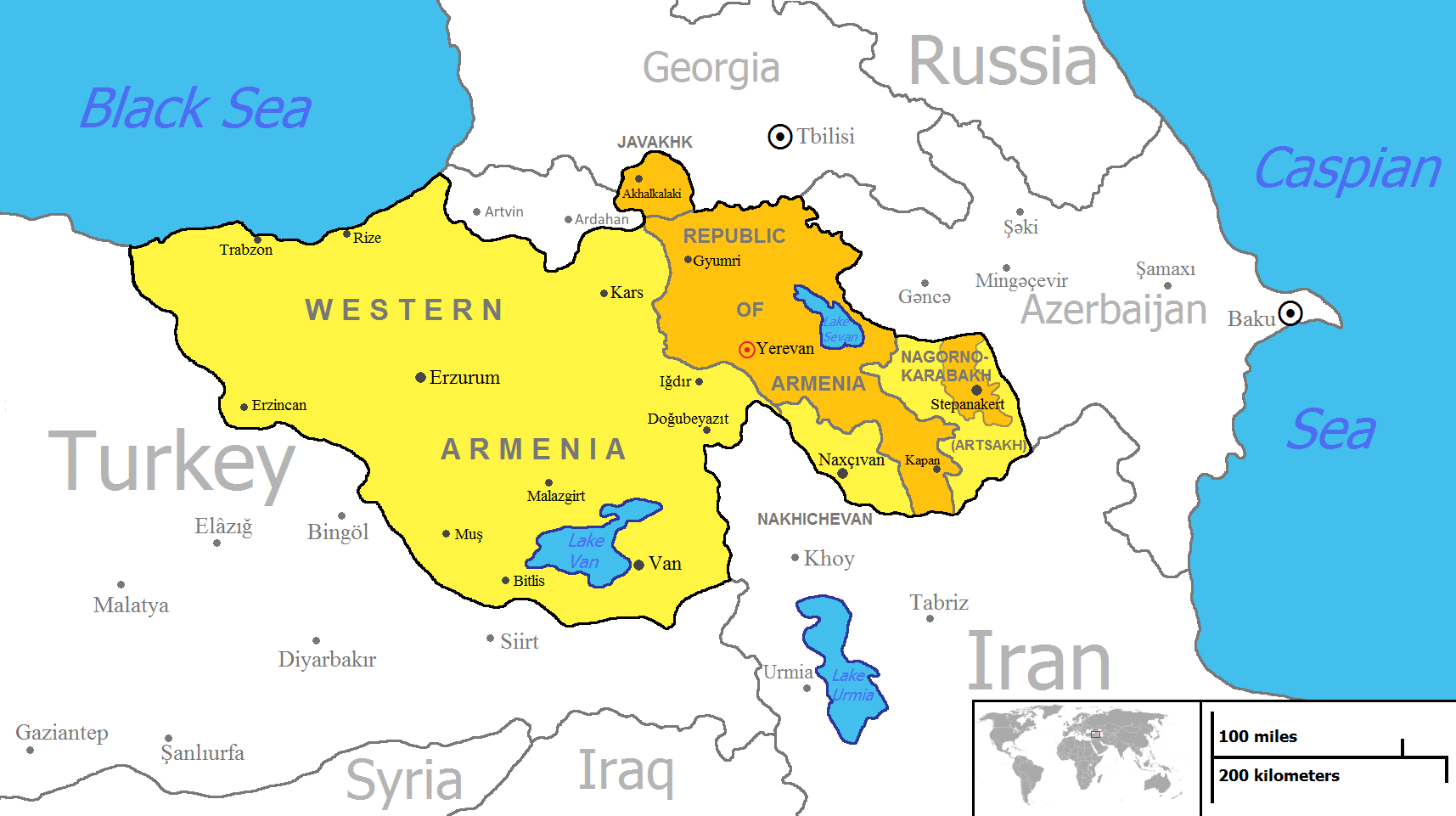
found this on some russian guy's websiteFAVORABLE FOR RUSSIA AND ITS ALLIES POLITICAL SITUATION IN THE CAUCASUS
This map is a representation of the author's point of view on the most favorable development of the situation in Transcaucasia for Russia and its allies (Armenia and Iran). The author realizes that nothing more ephemeral than this plan can be implemented in the region (with the exception of a counter Atlanticist-Turkic plan).
DESCRIPTION OF THE NEW BORDERS
- RUSSIA - From the Black Sea: along the former administrative border of the Abkhaz ASSR with the GSSR, then along the former border between Georgia and the Russian Federation, then along the former administrative border between the South Ossetian Autonomous District and the GSSR, then along the Greater Caucasus Range: to the Krestovsky Pass, then to the town of Bol. Then along the Alazani River to the beginning of the former border between Georgia and Azerbaijan, then along the former border between Azerbaijan and Georgia and Russia to the town of Bazardüzü, then along the Main Caucasian Range to the town of Babadag, then along the Velvelichai River to the Caspian Sea.
- ARMENIA - from the confluence of the Akhuryan and Arax Rivers along the border between Armenia and Turkey, then along the former border between Georgia and Turkey to the Kura River, then along the Kura River to the Javakheti Range watershed, then along the Javakheti Range watershed: Shaviklde - Didi-Abuli - Georgian-Armenian border, then to the former border with Armenia. The following are the main routes of the Caucasus Range: Shaviklde - Didi Abu - Georgian-Armenian border, then to the former border with Azerbaijan, along the former Georgian-Russian border to Bazardyuzu, then along the Main Caucasus Range to Babadag, then along the Geokchay River to its confluence with the Kura, then along the Kura River to its confluence with the Araks, then along the Araks to the confluence with the Akhurian and Araks rivers.
- IRAN- along the former border with Azerbaijan till the Talysh Mountains, then along the line of the main ridge of the Talysh Mountains till the Caspian Sea.
- ADJARI - along the former administrative border of Adjara AR with Georgia, then along the former border of Georgia with Turkey.
POLITICAL OBJECTIVES
The main objective of such a redivision of the borders is to restore Russia's political influence and presence in the region. For this purpose, the main objects of the dismemberment are the overtly pro-Atlantic countries of the region - Azerbaijan and Georgia. Firstly, it is necessary to isolate them from each other. This problem is solved by transferring the original Armenian lands, which are now part of Azerbaijan, to Armenia. The strengthening of Iran in the region, as opposed to Turkey, should be encouraged by the transfer under Tehran's control of the regions inhabited by the Talish, an ethnic group related to the Persians and exposed to all kinds of obstruction in Azerbaijan. Georgia should be separated from Abkhazia, South Ossetia and the territories of the mountain tribes (both in Georgia and Azerbaijan) in favor of Russia, as well as the ethnically Armenian region of Javakheti in favor of Armenia, which, together with the creation of the Republic of Adjara, which is under the protectorate of Russia, will lead to a significant reduction (ideally, of course, would be the complete absence) of Georgia's border with Turkey. Should this kind of situation develop and Russia and, consequently, Armenia strengthen, the status of Armenia's western border with Turkey and, in general, Western Armenia will undoubtedly become debatable.
POLITICAL BENEFITS
Russia gets Abkhazia and South Ossetia, which are de facto independent territories from Georgia and allied with Moscow. This step is long overdue and absolutely necessary. "Alignment" of further border with Georgia along the watershed line of the Great Caucasus Range is necessary for two reasons: first, it blocks any contacts between Georgia and Turkey standing behind it with the Russian North Caucasus, and second, it unites all Dagestani peoples within Dagestan. This purpose is served by adding the southern part of Lezghistan up to Velvelichai river.
Armenia receives the Georgian province of Samtskhe-Javakheti (Meskheti-Javakheti, in Armenian Javakhk), inhabited by Armenians, as well as the original Armenian territories, captured or given to Azerbaijan: Nakhichevan/Nakhjevan, Utik, Albania/Agvank, territory of mountain tribes, who have long practiced Armenian Christianity, as well as de facto independent Nagorno Karabakh/Artsakh.
Iran is taking over the lands of Talyshstan, inhabited by the related Talysh people.
That's a lot of non-Armenians in that Armenia.
Me: Mom, can I have a Greater Armenia made up of its former lands in the historical Western/Wilsonian Armenia?
Greater Armenia at home:Mom: No, we already have Greater Armenia at home.
Hope I'm not stretching the thread topic too much but:
View attachment 768002
found this on some russian guy's website
I agree, My guess is that sharing a border with Russia is the point though.That's a lot of non-Armenians in that Armenia.
Hope I'm not stretching the thread topic too much but:
View attachment 768002
found this on some russian guy's website
Likewise, the Azerbaijani irredentist side claims all of Armenia as being part of Azerbaijan, just because of some no-longer existent khanates that spanned the present day territory of Armenia. Not to mention the Azerbaijani-populated territories in northwestern Iran…That's a lot of non-Armenians in that Armenia.
https://en.m.wikipedia.org/wiki/Whole_Azerbaijan
Proposed by Azerbaijani historian Adalet Tahirzade
Includes the Iranian provinces of West Azerbaijan, East Azerbaijan, Ardabil, Kurdistan, Zanjan, Gilan, Kermanshah, Hamdan, Qazvin, Ilam, Lorestan, and Markazi.
Would someone mind making a Worlda and/or a QBAM out of this?
View attachment 768017
https://en.m.wikipedia.org/wiki/Whole_Azerbaijan
Proposed by Azerbaijani historian Adalet Tahirzade
Includes the Iranian provinces of West Azerbaijan, East Azerbaijan, Ardabil, Kurdistan, Zanjan, Gilan, Kermanshah, Hamdan, Qazvin, Ilam, Lorestan, and Markazi.
Would someone mind making a Worlda and/or a QBAM out of this?
Heres a Q-Bam. May not be entirely accurate though
I mean at that point, why not have Iran annex the remainder of Azerbaijan or partition it with Russia along the Kura River?Hope I'm not stretching the thread topic too much but:
found this on some russian guy's website
 I really think this is the biggest Armenia that doesn't include modern Turkish territory that I have ever seen.
alrighty since everyone seemed to like this, here's another of this guy's things:Hope I'm not stretching the thread topic too much but:
View attachment 768002
found this on some russian guy's website
TURKIC (ATLANTIST) - MUSLIM PROJECT FOR THE CAUCASUS
This map is a representation of the author's point of view on the most favorable development of the situation in Transcaucasia for Turkey and its allies (Georgia and the North Caucasian republics). The author is aware that nothing more ephemeral than this plan can be implemented in the region (with the exception of the counter Russian plan).
So I first learned about this guy's page from the vexillographia.ru page on Russian flag proposals, which linked to his "magnum opus" of sorts, a full-scale restructuring of the Russian Federation with flags for each new state:

I'm surprised this guy gave Iranian Azerbaijan to Greater Turkey, but only gave Turkey a tiny bit of southern Armenia. Maybe this is just because we're in a post-2nd-Karabakh war mindset, while he presumably made this soon after the 1st Karabakh war, but I feel like Armenia is more vulnerable than Iran, especially if Turkey and Azerbaijan are united. From what I hear, the Azerbaijani leadership talks about conquering Yerevan more than it talks about Tabriz.alrighty since everyone seemed to like this, here's another of this guy's things:
Lmao that he describes Klaipeda as 'mostly inhabited by Russians'.So I first learned about this guy's page from the vexillographia.ru page on Russian flag proposals, which linked to his "magnum opus" of sorts, a full-scale restructuring of the Russian Federation with flags for each new state:
Hello everyone! I'm back but with not another World War I Central Powers war aims (like many expected) but with some 1813 Napoleonic era aims. Specifically, what Napoleon was willing to give up during the setting sun of his empire; from 1813-1814.
I apologize for the extremely sloppy borders, I'm doing this late at night and wish to go to bed. However, reading Andrew Robert's Napoleon, A Life before bed, I stumbled across these proposals and couldn't help but map them out ASAP.

During Leipzig, Napoleon admitted to his secretary of state Fain, that he was willing to renounce the duchy of warsaw, Illyria, and the Rhine confederation. He said of Italy that he wanted "the integrity and independence of the Kingdom" which he left vague on purpose. So here I have it pictured as the actual kingdom of Italy as independent whilst Naples and the rest of Italy I left untouched since they're not mentioned. He also was willing to grant independence to the Hanseatic towns, Holland and Spain (all three pictured), but only after a "general settlement with Britain" (not pictured). I took the liberty of repartitioning Poland along the 1800 lines. Obviously, it could have been partitioned differently after an 1813 peace. just like it was OTL, but again, I did it to make it easy on me. I forgot to color Andorra, Switzerland isn't mentioned at all. Rhine confederation is sloppy, cause again, I'm focusing more on general borders. The same goes with Illyria. I apologize for the laziness >~<. Also, interesting to note, that an Austrian general named Maximilian Von Merveldt that was captured during Leipzig, was released soon and sent to the Austrian Emperor. He carried a proposal from Napoleon, to turn their armies on the Russians and push them to the Vistula.

AFTER Leipzig, Napoleon was forced to retreat to the Rhine. Here, he once again confided in Fain about possible peace proposals. The Allies were pushing for France to return to her natural frontiers and give up everything else. Britain wanted France to return to its 1791 boundaries. Napoleon confided in Fain the following terms he was willing to accept. He was prepared to surrender Iberia and Germany but refused Italy and Holland. Again Switzerland isn't mentioned. I assumed if he was giving up Germany, the duchy of Warsaw would be gone again as well. The map is again, sloppy.
He considered the peace terms that Britain offered at the end of 1813 (give up Belgium and return to 1791) but he ultimately refused and apparently agreed to the Frankfurt proposals. When Murat turned his Kingdom of Naples on Napoleon, it seems as though Napoleon expected to overthrow Murat once he had pushed the allies back (obviously that never materialized).
Thank you all for reading. Credit for the Idea goes to Andrew Robert's book, and the base maps go to Crazy Boris, love his maps <3
Also, small nitpick North Tension. The dude doesn't seem Russian, but an Armenian living in Russia, judging from his last name. It would explain why Armenia Is so large on the map. (source for the last name, I'm Armenian) the website is blocked by my antivirus due to a possible trojan tho LOL
I apologize for the extremely sloppy borders, I'm doing this late at night and wish to go to bed. However, reading Andrew Robert's Napoleon, A Life before bed, I stumbled across these proposals and couldn't help but map them out ASAP.
During Leipzig, Napoleon admitted to his secretary of state Fain, that he was willing to renounce the duchy of warsaw, Illyria, and the Rhine confederation. He said of Italy that he wanted "the integrity and independence of the Kingdom" which he left vague on purpose. So here I have it pictured as the actual kingdom of Italy as independent whilst Naples and the rest of Italy I left untouched since they're not mentioned. He also was willing to grant independence to the Hanseatic towns, Holland and Spain (all three pictured), but only after a "general settlement with Britain" (not pictured). I took the liberty of repartitioning Poland along the 1800 lines. Obviously, it could have been partitioned differently after an 1813 peace. just like it was OTL, but again, I did it to make it easy on me. I forgot to color Andorra, Switzerland isn't mentioned at all. Rhine confederation is sloppy, cause again, I'm focusing more on general borders. The same goes with Illyria. I apologize for the laziness >~<. Also, interesting to note, that an Austrian general named Maximilian Von Merveldt that was captured during Leipzig, was released soon and sent to the Austrian Emperor. He carried a proposal from Napoleon, to turn their armies on the Russians and push them to the Vistula.
AFTER Leipzig, Napoleon was forced to retreat to the Rhine. Here, he once again confided in Fain about possible peace proposals. The Allies were pushing for France to return to her natural frontiers and give up everything else. Britain wanted France to return to its 1791 boundaries. Napoleon confided in Fain the following terms he was willing to accept. He was prepared to surrender Iberia and Germany but refused Italy and Holland. Again Switzerland isn't mentioned. I assumed if he was giving up Germany, the duchy of Warsaw would be gone again as well. The map is again, sloppy.
He considered the peace terms that Britain offered at the end of 1813 (give up Belgium and return to 1791) but he ultimately refused and apparently agreed to the Frankfurt proposals. When Murat turned his Kingdom of Naples on Napoleon, it seems as though Napoleon expected to overthrow Murat once he had pushed the allies back (obviously that never materialized).
Thank you all for reading. Credit for the Idea goes to Andrew Robert's book, and the base maps go to Crazy Boris, love his maps <3
Also, small nitpick North Tension. The dude doesn't seem Russian, but an Armenian living in Russia, judging from his last name. It would explain why Armenia Is so large on the map. (source for the last name, I'm Armenian
) the website is blocked by my antivirus due to a possible trojan tho LOLAttachments
Last edited:
I don't wish to sound like a broken record, but will someone please fix the UK internal borders on these maps.
DePepezie your posts

Share: