Proposals and War Aims That Didn't Happen Map Thread

In March 1919, there were some negotiations between the Soviet government and an American delegation led by William C. Bullitt for a peace offer between the different factions of the Russian Civil War. What this would have resulted in if it was achieved would be an effective partition of Russia between the Whites and Reds at the current borders. You can read more on it in Wikipedia and this old thread (please no necro). I attempted to make a Worlda of what this would have resulted in.

View attachment 487174
This is the de facto situation on March 14, 1919.

View attachment 487175
And here is what this would have resulted in. I have taken out Entente occupation zones, as one term was Entente withdrawal, and also removed pockets of Bolsheviks behind the main frontlines.

I doubt anyone would accept that, especially Latvia, Poland, Lithuania, Ukraine, neither the Whites.
 
map-story_647_081015061820.jpg


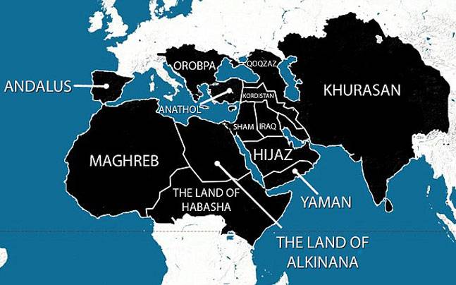
isis proposed land claims according to india today
 
What’s the area in the middle that wouldn’t be annexed?
The remainder of the West Bank
The remainder of the West zbank was not shown in the map on BBC. Given the settlements, and a past proposal that was similar in which Palestine would be an area with no border with Jordan and easily cut in four with three bottlenecks, it can be assumed there would be a fair bit taken elsewhere as well. And of course as much of the aquifers as possible.

EDIT:

Ahhh wait, I see there is a second map further down.
 
Last edited:
upload_2019-9-16_23-0-57.png


The state of Frankland, as described here. That article actually contains a map, but it's not faithful to the described borders, as it uses the OTL North Carolinian western border when the actual description refers to "the heights that divide the sources of the waters that fall into the Mississippi, from those that empty into the Altantic", ie the eastern continental divide.
 

Crazy Boris

Banned
View attachment 488476

The state of Frankland, as described here. That article actually contains a map, but it's not faithful to the described borders, as it uses the OTL North Carolinian western border when the actual description refers to "the heights that divide the sources of the waters that fall into the Mississippi, from those that empty into the Altantic", ie the eastern continental divide.

Wow, I had no idea that Franklin/Frankland was so big. I’ve always assumed it was the sliver in eastern Tennessee that’s usually shown.
 
Another day, another dystopian manifesto:

In the year 2009, American strategist George Friedman published the book The Next 100 Years, which is supposedly a set of predictions about the geopolitics of the 21st century. A while ago I read the book and it quickly became clear to me that, while the stuff he says could be seen as mere forecasting, it also kind of sounds like a series of suggestions and plans, with the ultimate goal of crushing Russia, China and other Eastern Bloc nations, and then permanently asserting global dominance by defeating the allies-turned-enemies of Turkey and Japan. For reference, here's a couple interpretations of what his world looks like in 2050, right before the "third world war" which he says would only take half a million lives:

YGb8Fl0P1LRzFS1OClLdRWJyPQpbViEXVS9Bi2uev0Y.png

the-next-100-years-map-pre-ww3-png.114293


In a way, this kind of seems like the exact reverse of Dugin's Foundations of Geopolitics, displaying a similar end goal except for the opposite side.
 
Last edited:
Top