You are using an out of date browser. It may not display this or other websites correctly.
You should upgrade or use an alternative browser.
You should upgrade or use an alternative browser.
OTL Election maps resources thread
- Thread starter Thande
- Start date
Quick question everyone - do you think the full map would be better with or without thicker black lines between the counties? I can upload both versions if necessary.
With - all the better to distinguish the counties with.
Quick question everyone - do you think the full map would be better with or without thicker black lines between the counties? I can upload both versions if necessary.
This is a map of local council elections, right? In that case, the black lines seem like they would help, unless they compromise the level of detail.
Thande
Donor
Ahhh - at long last, here they are: http://ajrelectionmaps.deviantart.com/gallery/59074385/United-Kingdom
Thanks to @Alex Richards and everyone who helped in a smaller way, what an achievement in the psephological community.
Thanks to @Alex Richards and everyone who helped in a smaller way, what an achievement in the psephological community.
Thande
Donor
I have now also uploaded simplified winner-only maps for the Normie Community.Ahhh - at long last, here they are: http://ajrelectionmaps.deviantart.com/gallery/59074385/United-Kingdom
Thanks to @Alex Richards and everyone who helped in a smaller way, what an achievement in the psephological community.
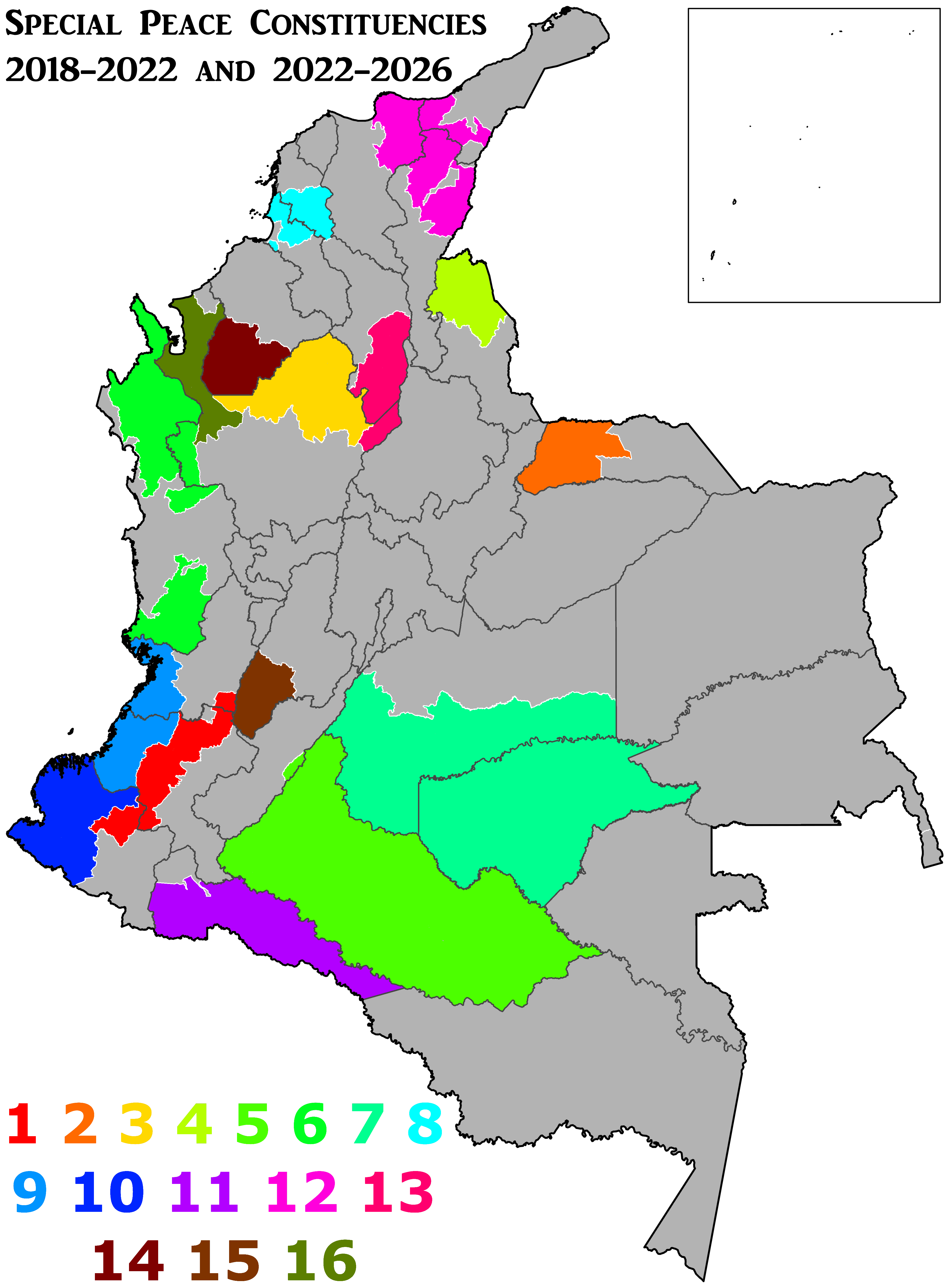
So, a brief thing before the storm that all you admirable mapmakers will make in this thread in the local elections (because seriously, people, Jesus Christ, you're tireless at UK ward stuff, I'm impressed, you do amazing work there): a fundamental part of the peace deal with FARC is that Colombia now has FPTP constituencies.
Well, probably. There's sixteen new "Special Constituencies for Peace" that are destined towards some of the poorest rural municipalties, where the rule of law has never really applied. The point here is to attempt to solve the issues that created FARC in the first place (an institutional vacuum in the fields), which comes hand-in-hand with the agrarian reform project. I'm not quite sure about how these constituencies will operate, with a few caveats:
Anyways, this reform elevates the size of our lower house (the Chamber of Representatives) from 166 to 182.
The demographic details, courtesy of La Silla Vacía (sorta like our Politico, I guess? If you read Spanish there's some awesome stuff about Colombian politics there) are as follows:
These constituencies will come into effect in the 2018 elections, and will cease existing at the end of the 2026 period - lasting a total of eight years.
Without further ado, here's the map:
Well, probably. There's sixteen new "Special Constituencies for Peace" that are destined towards some of the poorest rural municipalties, where the rule of law has never really applied. The point here is to attempt to solve the issues that created FARC in the first place (an institutional vacuum in the fields), which comes hand-in-hand with the agrarian reform project. I'm not quite sure about how these constituencies will operate, with a few caveats:
- Traditional parties and FARC can't compete in the areas, and
- Political movements that are trying to get seats in the national lists, or the special lists for natives and afro-Colombians won't be able to participate in elections here,
- Special Constituencies don't include large urban aresa that are within their territory. This is specifically notable in the urban areas of Tumaco, Buenaventura, Caucasia and the departamental capitals of Santa Marta and Valledupar - except for Santa Marta (which is a hellhole anyway
 ) and Valledupar, IMO, a terrible idea, considering these are amongst the poorest cities in Colombia.
Anyways, this reform elevates the size of our lower house (the Chamber of Representatives) from 166 to 182.
The demographic details, courtesy of La Silla Vacía (sorta like our Politico, I guess? If you read Spanish there's some awesome stuff about Colombian politics there) are as follows:
- Constituency 1 has 812,148 inhabitants and is located in the western departments of Cauca, Valle del Cauca and Nariño.
- Constituency 2 has 169,974 inhabitants and is located in the eastern department of Arauca (still plagued by violence by the ELN)
- Constituency 3 has 476,372 inhabitants and is located in Antioquia, in the northwest.
- Constituency 4 has 144,103 inhabitants and is composed of the Cataumbo region in northern Norte de Santander, in the border with Venezuela,
- Constituency 5 has 514,673 inhabitants and is composed of the entirety of Caquetá department, plus a single department in Huila (this is the zone of highest FARC concentration),
- Constituency 6 has 209,084 inhabitants and is located mostly over northern Chocó, although also has departments in southern Chocó and Antioquia. It's notable for being the constituency where the Bojayá massacre (the largest massacre by FARC) ocurred.
- Constituency 7 has 272,157 inhabitants and is located in southern Meta and all of Guaviare, also heavily affected by FARC,
- Constituency 8 has 362,286 inhabitants and is located in the Montes de María region in the central Atlantic coast, near Cartagena,
- Constituency 9 has 487,950 inhabitants and composes the Pacific coast of Cauca and Valle del Cauca - the trading hub of the Colombian Pacific (and also Colombia's crime capital),
- Constituency 10 has 448,365 inhabitants and composes the Pacific coast of Nariño - the coca exportation capital of Colombia,
- Constituency 11 has 272,637 inhabitants and is located in southern Putumayo - the area where Shining Path and FARC used to sorta meld together (I'm only half joking),
- Constituency 12 has 1,371,062 inhabitants and is located in Guajira, Magdalena and Sucre - home of the largest Native communities, the birthplace of García Márquez, and Colombia's largest drug plantations,
- Constituency 13 has 170,144 inhabitants and is located in the Magdalena River in Bolívar and Antioquia - the bottleneck for riverbound trade,
- Constituency 14 has 296,887 inhabitants and is located in southern Córdoba - home to huge ranches and paramilitary-FARC violence.
- Constituency 15 has 124,330 inhabitants and is located in southern Tolima - this is where FARC started, and where they tried to set up their peasant communes early on.
- Constituency 16 has 648,597 inhabitants and is located in Urabá, Antioquia - drug trade's gateway to North America, and one of the highest-hit areas of the country.
Without further ado, here's the map:
Thande
Donor
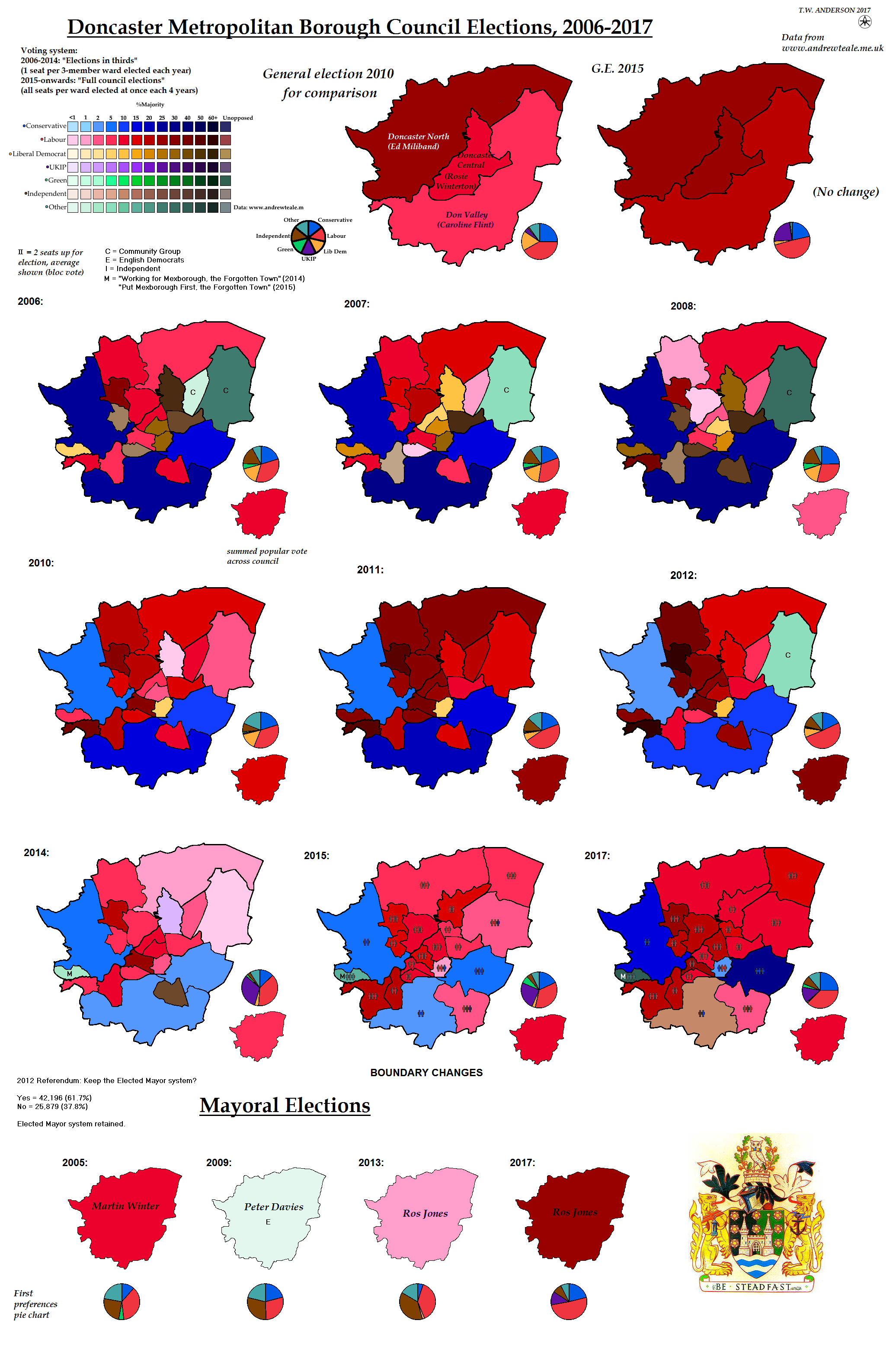
Oxfordshire and Worcestershire also seem to have good websites if you're interested in those. I promised myself I wouldn't do another map for a while, but I suspect I may have to update the Doncaster map series (on the current basemap as it's the tracing part I don't like doing).Thanks to a remarkably good website, Leicestershire is updated.
Thande
Donor
Here is Doncaster in all her glory.
Not sure whether to upload it to the dA as the format is a bit different to the other ones we've been using.
Not sure whether to upload it to the dA as the format is a bit different to the other ones we've been using.
Here is Doncaster in all her glory.
Not sure whether to upload it to the dA as the format is a bit different to the other ones we've been using.
I guess Doncaster is what happens when UKIP voters stay home, compared to Prudhoe which happens when they all go Conservative. Though that interpretation could be wrong.
Whether the nation as a whole is more like Doncaster or Prudhoe will determine whether May gets 380-ish or 450+ seats.
Thande
Donor
I'm not sure if that's fair given that UKIP was a very transient phenomenon in Doncaster and was really just the latest manifestation of 'whoever's anti-Labour and not the Tories' which in the past was Lib Dems and independents, then Eng Dems, and in the future might well be Yorkshire Party as U's M thinks - and, of course, it's usually the same people involved regardless of party, like how the local top UKIP bloke in my area used to be the top Lib Dem bloke.I guess Doncaster is what happens when UKIP voters stay home, compared to Prudhoe which happens when they all go Conservative. Though that interpretation could be wrong.
Whether the nation as a whole is more like Doncaster or Prudhoe will determine whether May gets 380-ish or 450+ seats.
Thande
Donor
Lib Dem losses to the Tories but gains from Labour - how very late 2000s.I've updated Derbyshire as well. Some very odd results for the Lib Dems.
Gian
Banned
So, with the second round done, here's the collaborative project for the French elections by (traditional) province (unfinished).
So far, I only have the first round only. It's real slow just to get those results compiled. Meanwhile, only @Minnesota_Nationalist and I are working on this on Althistoria, but volunteers are welcome in both threads.

So far, I only have the first round only. It's real slow just to get those results compiled. Meanwhile, only @Minnesota_Nationalist and I are working on this on Althistoria, but volunteers are welcome in both threads.
Gian
Banned
That said, I still need help compiling those province data together (Me and @Minnesota_Nationalist can't do this by ourselves), so I really could use the help.


Share: