MotF 190: So Far From God

MotF 190: So Far From God

The Challenge

Make a map showing a country, state, or city overshadowed by a larger or better-known neighbor.

The Restrictions

There are no restrictions on when the PoD of your map should be. Fantasy, sci-fi, and future maps are allowed.

If you're not sure whether your idea meets the criteria of this challenge, please feel free to PM me or comment in the main thread.

---
Entries will end for this round when the voting thread is posted on Monday, February 4th, 2019.
---

PLEASE KEEP ALL DISCUSSION ON THE CONTEST OR ITS ENTRIES TO THE MAIN THREAD.
Any discussion must take place in the main thread. If you post anything other than a map entry (or a description accompanying a map entry) in this thread then you will be asked to delete the post.

Remember to vote on MotF 189!
 
Last edited:
dcxwm93-74cd3369-9916-4de5-83db-1ea9af2fdb62.png


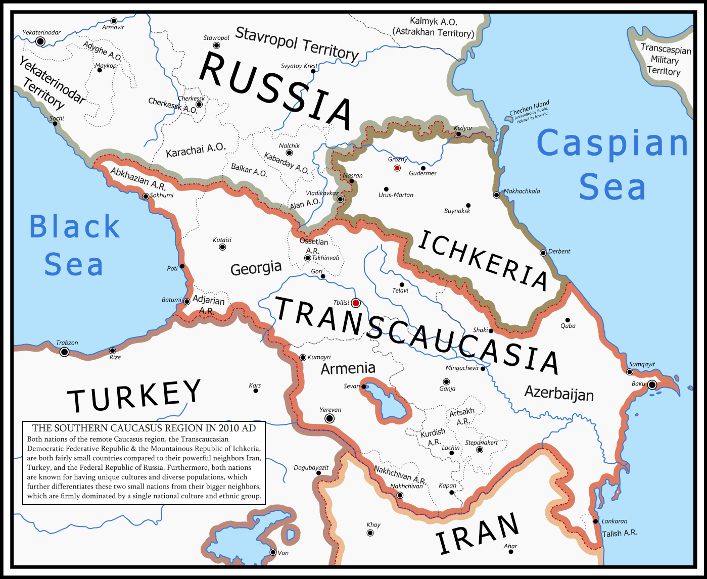
Following the Russian Revolution of 1917 several border regions broke away as the imperial system which had dominated Russia for more than 350 years crumbled. One of the regions which saw successful campaigns for independence was the Caucasus region.

Thanks to German aid, the people of Georgia, eastern Armenia, and northern Azerbaijan gained sovereignty, but, partially to defend themselves against Germany's collapsing Ottoman ally, and to protect themselves against future Russian intervention, they banded together as the Transcaucasian Democratic Federative Republic. While losing small territories to Turkey, the Ottoman Empire's successor state, these three different people groups managed to survive the troublesome 1920s while neighboring Russia underwent a bloody civil war.

On the northern slopes of the Caucasus, several Muslim groups tried to gain independence, but only the regions of Chechnya and Dagestan managed to achieve victory against the Russians. Inspired by their bigger southern neighbor, these two regions banded together to form Ichkeria, using both the mountainous nature which had influenced their cultures and their shared Muslim faith as the foundation for their new republic. Ichkeria was always more affected by the whims of the Russian bear with which they share a border, and it also has been perceived as a very different country than any of their neighbors, being seen as neither Middle Eastern nor as European.

Both countries today have only a small presence on the world stage. Transcaucasia is known best for its vibrant music scene, which allowed it a cult following in the Pan-European music competition "Songs of Europe". However due to the country's neutrality and the relatively small population of 18 million people, it is a relatively obscure country, especially compared to its big three neighbors. Otherwise some wine connoisseurs might be familiar with Georgian wine, and Armenians are a widespread people because of the Armenian diaspora.

Ichkeria is even more obscure than Transcaucasia though, mostly due to its small population of just 3.5 million people, and its anomaly status of being the only country in which North Caspian people are the majority. Due to these facts and even a simple lack of EBU membership (in contrast to other nearby countries like Transcaucasia, Russia, and even Turkey), the small nation is known to few people who aren't interested in geography, foreign policy, or ethnography. However it is noteworthy that Ichkeria has a territorial dispute with neighboring Russia over Chechen Island, an uninhabited islet in the Caspian Sea under Russian control. Also some Chechen volunteers have fought in the many minor revolts Russia experienced in its Muslim territories in the past few decades.
 
Last edited:
In 2238 a plan was announced to tent over Lyot Crater in the hinterlands of the Borealis Planita on Mars. The crater, covering an area of 52,000 square kilometers, would become an oasis in the Martian desert, the largest habitable region in the Solar system outside of Earth. Similar projects planned for Copernicus Crater on Luna never materialized, so this would be the first of its kind.

The project took thirty years and millions of people's involvement. Air was generated from comets brought in from the Kuiper Belt, as was water. genetic engineering created microbes that fixed nitrogen into the regolith, creating soil for the first time on Mars. The domed tent wold soar five kilometers in the air, held up by the greater pressure underneath it. The specialized polymer would trap in heat, aided by orbital mirrors that would focus the sun's energy.

Lyot was officially ready for habitation in 2270, thirty-two years after the project began. For decades it was the largest single area of habitation on Mars, home to over forty million people in several major cities. Urban farming vastly multiplied the amount of food being produced in Mars's own farms, and wilderness areas were designated along the rim of the crater. Lyot was an engineering marvel the likes of which humanity had never before seen- a prelude to what Mars would look like centuries hence, when the terraforming project was completed and Mars was a new Earth.

In 2272 the Mariner Valley Project was commenced, a plan to tent over Valles Marineris, Lyot on a far grander scale. It was joined by a similar project in Agyre Planita, a plan to make the low-lying area into the breadbasket of Mars. It would be sixty years before that project was completed, but when it did the Mariner Valley would far overshadow Lyot. Agyre would supply food for most of the Middle System including most of Mars and the Belt, while Mariner would support a population density comparable to the Kanto Plain on Earth, which was slowly fading into the background itself.

Once the center of Martian society, Lyot is now a relatively sleepy backwater on Mars. Rain Day, in 2314, was the first day actual rain fell on Mars, in Hellas Planita. By now lakes line the surface of that dense basin, and most days its warm enough to leave the habitats wearing only an oxygen mask. Pika are the main creature that live in Hellas, and other animals may soon follow, as even Mariner and Agyre will eventually be rendered obselete as Martians will be able to emerge from their domed habitats and live under the open surface. By then Borealis Planita will become an ocean, and Lyot will likely be flooded. Nevertheless, the Lyotians are proud of their home for now, no matter how much the planet has grown around them.

upload_2019-1-26_14-56-52.png
 
1tcEBGs.jpg


In the aftermath of the February Revolution, three competing governments formed in what had been Russian Turkestan – the Islamic Council, led by the modernizing and pro-British Jadidists; the Council of Elders, led by the conservative Islamist Ulemas; and the Tashkent Soviet, a Bolshevist group dominated by ethnic Russian settlers. For some time these governments coexisted in an uneasy peace, but with the October Revolution the Tashkent Soviet attempted to seize total control, sparking violent riots. After the Soviet crushed these riots, the other two factions fled to the city of Kokand, where they formed a united front with British technical and materiel support.

After the eventual victory of this Turkestan National Army over the Tashkent Soviet in 1919, British influence quickly moved into the region, resulting in a consensus on independence between the modernizing Jadidists and the traditionalist Ulemas. In August of 1919, a now-united Turkestani National Council declared the Kingdom of Turkestan, a nominally-parliamentary monarchy under the former Emir of Bukhara. The Jadidists hoped that the influence of the Council as well as British support would allow the country to modernize, but the rapid emigration of the ethnically-Russian technical elite as well as the continuing conservative majority on the Council and within the royal court left the country essentially in stagnation, literacy remaining low and its primary exports remaining raw materials.

Warlordism, banditry, and general lawlessness in the desert regions never ended after the Russian Civil War, but the situation was made much worse by events in Xinjiang, the Chinese region bordering Turkestan to the east. Turkic guerillas fought a series of Chinese warlords starting in 1928 in Xinjiang, often with the support of conservative elements of the Turkestani government. When the Chinese central government reestablished control over the region following the end of the Second World War, many of these units managed to escape across the border with their arms.

Over the next few years, this spillover caused Turkestan to collapse into a series of civil wars between Islamic and secular governments and eventually become a battleground for influence between the expanding spheres of influence of China, Russia, and Britain.
 
upload_2019-2-2_17-21-30.png


“Poor Shuewan prefecture, so far from God, so close to Hong Kong”


Mayor Thérèse Oiselet

(Pronounced Shueh-Huan because of overcorrection. The name comes from the Shuiwantou Bay, the small Eastern bay)


Shuewan is a French possession on the Pearl River’s delta. Northern to Hong Kong, and Western to Macao, the city never took off as Hong Kong did. The city was exchanged for advanced technology between Louis XIX de Bourbon-Orléans and the Chinese dowager empress Cixi. The deal was done in 1874, and an Administrator arrived in September. The city become a small trade point for French merchants, even though Macao and Hong Kong were both bigger and more adapted to big ships.

It didn’t grow very large until in 1891 the Mayor Lucien d’Albret decided that the city would be less regardant towards semi-legal things such as brothels, underqualified medical care and counterfeit goods. Many artists, singers and writers started to talk about this place as the “Pink city”, but not talking about the colour of the walls. Hongkongese who couldn’t afford healthcare or other services were going to Shuewan, and the economy of the city developed in these unsafe conditions.

The city soon became unsafe and had to deal with crippling corruption. The King didn’t even went through the city during his Asian Tour of 1901, because he was ashamed of it, and neither the neighbouring cities or the Chinese Empire wanted of it. The Town Hall was burned by a criminal fire and rebuilt. Even the tiny chapel was used as a place for counterfeit selling when the night came.

And then Thérèse Oiselet was elected Mayor in 1921. She arrived with the wave of immigrants who fled the post-WW1 poverty. She was elected upon her program of “Security, Benevolence, Virtue”, and received help from a Catholic mission in Hanoï and a protestant mission from Tahiti. The Catholic Sisters will deal with Healthcare, the Protestant would educate the masses, the Town Hall would give them a job.

The city was “grounded”, to quote Sister Yolande, as a child would be, walls were built around the city to avoid people getting in the city and feeding the organized crime, and a curfew was decided at 9pm so that people couldn’t go to the brothels. To give everyone a job, parks were built, woods were planted, the Sisters taught the workless to sew. Some hills were terraced so that people could produce food instead of importing it, and a Botanic Institute was created to develop plants that could grow on polders while providing foods.

The “Eastern Pigalle” became, in a decade, a beautiful city with prestige and that could even resist the Black Friday better than most of the world. An immigration wave from Limoges, Nice and Cannes replenished the city a bit more, and manufactures were created, with the knowledges of both French and Chinese chinaware makers. Actual funding was sent by the French government that started to acknowledge the existence of the city. The Pope gave the authorization to build a Cathedral, and the symbolic name of Madeleine was chosen, the show how the city had been redeemed because it dared hoping for a better life.

The curfew was finally lifted in 1935, and the city became a centre of tourism: the aquarium and the Promenade des Niçois were inaugurated as a collective effort and it’s exploitation by the Town Hall helped the administration to reimburse it’s debts. Several small turbines were created to power the city lights without poisoning the people, and the Maraîcherie (a neologism created from the maraîchers, the people who sell fruits) began the give it’s first shrimps, fishes and seaweeds.

The city was left to the Japanese during WW2, but under the very careful watch of the Mayor, who refused that the soldiers enter inside the walls of the city. The Synagogue was burned down to pretend that Jews left the city a long time ago, while they were hidden in the caves of the nun’s convent. When the Japanese had to retreat in 1944, they couldn’t burn the city or sack it due to the heroic resistance of the inhabitants.

After the end of WW2, the members of the Qing Dynasty that didn’t participate to the government of Manchukuo or the military invasions were allowed to stay in the city, and the Neighbourhood soon took the name of Quartier des Mandchous, and the middle school that was built with their funding was named the Tseu-Hi Middle School. Soon, the educative system was reformed to get everyone a complete scholarship.

During the 60’s, the city became an important touristic place again, cafés, hotels and small shops began to spring all around the city. The Bicycles and Tuk-Tuks imported from Indochina became important ways of moving through the city. It became a very populous place, with many flats with 3 to 8 floors, and small theatres and shops under housings. Shuewan Plage was also created by blocking some of the small valleys to create a reservoir. This decision due to the pollution of water by Chinese industry. The city also became the centre of the Chinese ecologist movement, due to the well managed state of the ecosystems in Shuewan.

Today, the city is still a French prefecture, and the people join the city through the HKSM Airport: Hong Kong-Macao-Shuewan. The Socialist-Ecologist government of the RPC has decided to normalize the relationships with Taiwan, and the meeting occurred in Shuewan, due to the historical tights between the city and the two governments. The city is mostly autonomous, and people are strictly checked to have neither weapons or illegal substances before they enter through one of the doors. The GDP/capita is smaller than in Hong Kong however, and the 35 000 inhabitants don't compare with the Hongkongese 4 millions.

Main touristic features include: the Ecumenical Choir, that performs songs every sunny afternoon during summer; the Promenade des Niçois and the Shuewan Aquarium, that has the last group of pink dolphins (they are working with several Chinese and European Institutes to reintroduce the dolphins in the Chinese rivers, but it will be complicated); the animated Petite Baie district, with cafés, music halls and it’s musicians; the Halles marketplace, that will provide you with local freshly grown food; the different woods and parks; and the shows at the Toulouse-Lautrec cultural center.


(Sorry for the French words, but I was feeling that it would look odd in English as it was a French city)
 
A special thanks to @TheKutKu for inspiring this map and giving me helpful advice

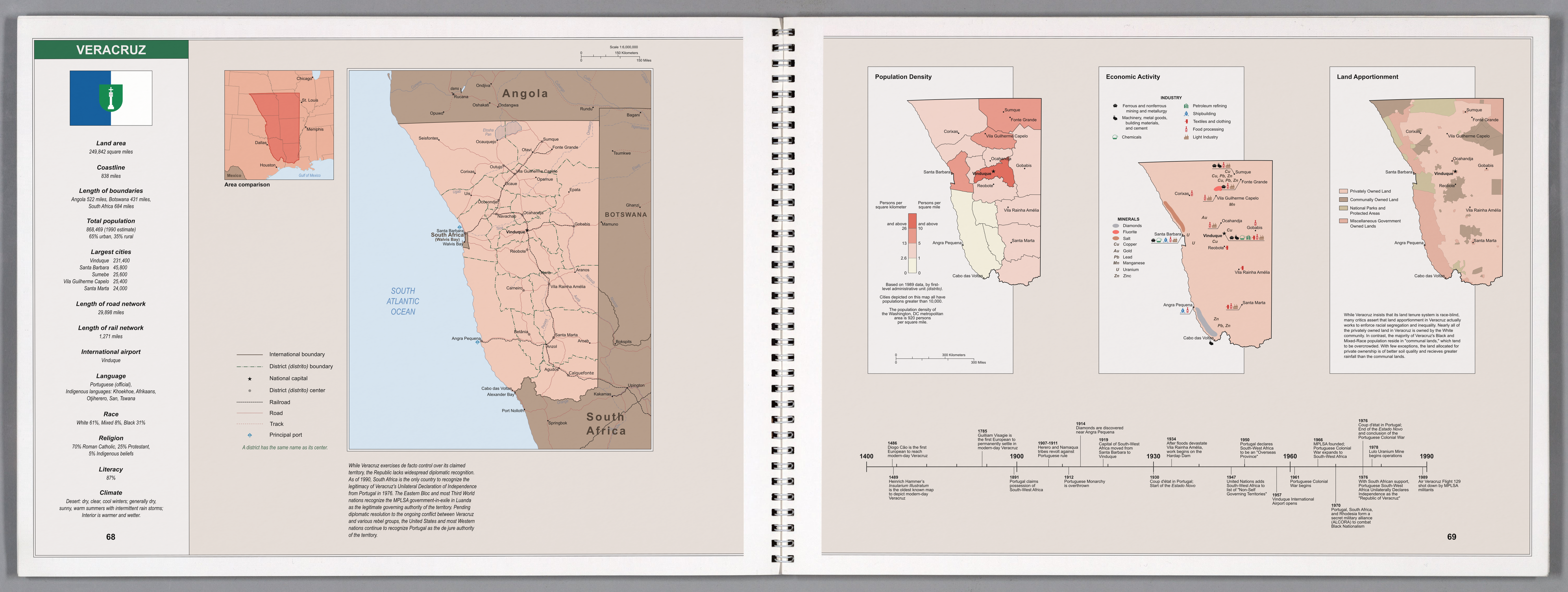
POD: Adolf Lüderitz contracts Malaria and dies in 1881 while operating a factory in British Nigeria. As consequence, Imperial Germany does not press a claim to Namibia during the 1880s.

---


Opinion: Don’t be too hard on Senator Wilson – Veracruz is a truly forgettable country.


By Richard Miller - Foreign Policy Analyst

Wednesday, March 13, 1991


This past week, much has been made of Senator Matt Wilson’s (D-MO) gaffe during a Senate Foreign Relations Committee meeting. Senator Wilson, while making a speech in favor of increasing sanctions on Veracruz, talked of the dangers of having a “White Supremacist nation filled to the brim with South African Nuclear Weapons on the other side of the Gulf of Mexico” and went on to speculate that the nation was assisting clandestine drug trafficking efforts into the United States. Senator Wilson was apparently under the impression that Veracruz was located in Latin America – when in fact the nation is located on the other side of the Atlantic in Southern Africa. Republicans – hoping to unseat Senator Wilson in 1992 – have suggested that this gaffe shows the aging incumbent is no longer fit to serve, while columnists and satirists have made all sorts of jokes at Wilson’s expense.


The gaffe was certainly embarrassing for Wilson, but the amount of grief he has received is way out of proportion to what he deserves. The truth of the matter is - unless you are a career diplomat or foreign policy analyst – you probably have never heard of Veracruz before this past Monday. It is truly a forgettable country.


Modern-day Veracruz was discovered by Diogo Cão in 1486 as part of Portuguese efforts to circumnavigate Africa. The Portuguese paid little notice to their new discovery. The Portuguese quickly figured out that they could reach the Cape of Good Hope by tacking West into the Atlantic (making use of trade winds and currents) in much less time than it would take to sail down along the coast of Africa (where the Portuguese would have to sail against the Benguela Current). As consequence, the territory was almost entirely untouched by Europeans for the following four centuries. While the discovery of guano in the Penguin Islands prompted their annexation by the British Cape Colony and growth of the whaling industry in the South Atlantic led to an establishment of a settlement at Walvis Bay – the remainder of the territory was largely ignored by Europeans apart from missionaries. Indeed, in the 1870s, the British rebuffed numerous entreaties by the natives of the territory to be placed under British protection. Southwestern Africa was viewed as mostly worthless territory – more expensive than it was worth to occupy. However, all that would change in 1891.


In what has to be one of the greatest diplomatic betrayals of the 19th century – the British thwarted Portuguese ambitions to link their Angola and Mozambique (the “pink map” project) by occupying vast swathes of Central Africa at the behest of mining magnate Cecil Rhodes, which were then placed under British rule. Portugal did not expect her ally of over 500 years to betray her in this matter by flagrantly ignoring her longstanding colonial claims – and subsequent Portuguese failure to secure even a reduced pink map corridor led to the collapse of Prime Minister António de Serpa Pimentel’s government and general demoralization of the country (in addition to a wave of anti-Anglo sentiment). The new Prime Minister, João Crisóstomo de Abreu e Sousa, looking to secure his political position sought a cause to rally his countrymen and raise their demoralized spirits. To counter prevalent images of Portuguese weakness, Abreu e Sousa’s government invoked the discoveries of Diogo Cão and Bartolomeu Dias, and advanced a claim on the hitherto unclaimed South-West Africa. While some in the British Cape Colony protested the move – London was content to allow Portugal this consolation prize. Portugal was thus afforded a free hand to colonize the territory.


Portuguese South-West Africa was a prestige colony more than anything else. The colony ran horrible deficits (which the Portuguese government struggled to pay – a factor some say led to the overthrow of the Portuguese Monarchy in 1912) until the discovery of Diamonds in 1914 and was administered as little more than an appendage of Portugal’s much more valuable Angola colony. Indeed, until 1950, Portuguese South-West Africa “shared” a governor with Angola (which is to practically say that Angola’s governor had an extra responsibility). Little occurred in the territory besides ranching, farming, and some mining. Despite the territory’s large size and available farmland, Portuguese colonists overwhelmingly preferred to move to Angola or Mozambique. By 1970, no more than 300,000 people – colonist and indigenous – lived in Portuguese South-West Africa (even if Whites made up an appreciable share at around 30-35%). The territory was generally an afterthought to Portugal’s technocratic dictatorship.


In 1976, a coup d’état in Lisbon brought down Portugal’s dictatorship, and the new government in Lisbon immediately began negotiating with the various rebel groups in their colonies to negotiate a transition to Independence. Despite the fact that the MPLSA (the main rebel group in South-West Africa) had never accomplished much besides a few small raids into South-West Africa – they were given a seat at the table and were largely expected to assume control of the territory within a year or two.


The South Africans had different plans. Fearful of being surrounded by nations sympathetic to Black Nationalism – and to preempt a possible refugee crisis on the part of the large Portuguese settler community in Africa – South African Intelligence worked with prominent members of the settler community in South-West Africa to orchestrate a Unilateral Declaration of Independence from Portugal well before the transfer of power to the MPLSA could occur. On September 14, 1976, a settler paramilitary group seized the radio station in Vinduque and proclaimed the establishment of the “Republic of Veracruz” (named after Padrão set up by Diogo Cão and Bartolomeu Dias). Thereafter, elite South African troops quickly poured across the Southern and Walvis Bay borders and South African paratroopers landed at Vinduque’s airport to secure the new settler regime. As the Portuguese army in South-west Africa was almost entirely comprised of local settlers, it gave way to the UDI without any real resistance.


The new Republic found (and continues to find) itself diplomatically isolated. Only South Africa recognized the validity of the Veracruz UDI. The Eastern Bloc and Third World has contended that the MPLSA was the legitimate representative of the people of South-West Africa and afforded diplomatic recognition to the MPLSA government-in-exile in Luanda. While the United States and many Western nations were hesitant to recognize the MPLSA government-in-exile due to the organization’s Communist ties – recognizing Veracruz was equally unacceptable, so a weird legal situation has persisted where America and her allies continue to recognize Portugal as the de jure authority in South-West Africa (despite the latter’s intent to decolonize the territory).


As Angola and Mozambique descended into civil war after attaining Independence, many Portuguese settlers relocated from those territories to Veracruz – which had always had a reputation for being safe, even during the height of the colonial war. While these relocations gave the territory a slight White Majority - they also put tremendous strain on the economy of the country (which was further hurt by the newfound diplomatic isolation). Even though this economic disruption has been mitigated somewhat in subsequent years – Veracruz is still quite dependent on support from South Africa and is informally derided as “South Africa’s Fifth Province.” For this reason, Anti-Apartheid activists have largely ignored Veracruz (focusing their efforts against Pretoria), and most foreign policy analysts believe that toppling South Africa’s Apartheid regime will automatically force the Veracruz regime to the table. Accordingly, direct engagement with Veracruz has remained a peripheral concern of the United States, and for good reason. We have much bigger fish to fry in that region.


Senator Wilson may have embarrassed himself this past Monday, but so too have the armchair-diplomats who have advanced the absurd notion that expertise on the situation Veracruz is requisite to be a United States Senator.

dcyrklr-f5b8df15-d23d-488b-9412-8d73bb2b27f6.png
 
Last edited:
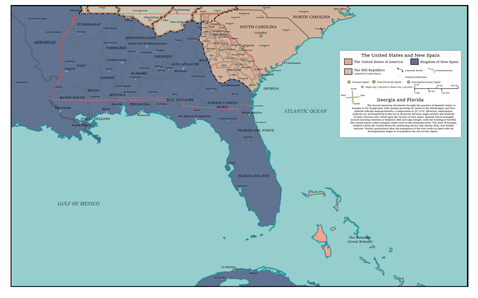
"Poor Georgia, the wretched Southern child, not as rebellious as the Carolinas or as potent as Virginia, she is too close to Florida, too far from God."

- Abraham Webster, 1830

poor_georgia_2__the_abriged_series__by_spazzreflex_dcysyh2-fullview.jpg
 
Last edited:
Top