Map Thread XX

Status
Not open for further replies.
The New Luxembourg Timeline is slowly taking shape! This took a while lol, been having fun thinking of more and more ideas for my weird Alternate World!
NewLuxMapEC.png

"...The common misconception is that the 'Scramble for the Americas' was a instant thing, but it was mainly the opposite. Despite having large colonial presence the great powers of the time didn't give their North American colonies much support this debatably lead to the formation of the United States as they revolted against the French, Spanish, and English rule, but they where a diamond in the sands... "
- The Race for America (2011 Edition) by Alexander P. Johnson
 
The New Luxembourg Timeline is slowly taking shape! This took a while lol, been having fun thinking of more and more ideas for my weird Alternate World!
View attachment 656513
"...The common misconception is that the 'Scramble for the Americas' was a instant thing, but it was mainly the opposite. Despite having large colonial presence the great powers of the time didn't give their North American colonies much support this debatably lead to the formation of the United States as they revolted against the French, Spanish, and English rule, but they where a diamond in the sands... "
- The Race for America (2011 Edition) by Alexander P. Johnson
Still not overly pleased with over convergent northern New Jersey border, or the western border of Virginia for that matter which appears to be identical to the arbitrary boreder of Pennsylvania
 
I would, but I'm unsure if wikipedia has any rules pertaining to aesthetics/design choices. From what I saw, their election maps have a very uniform, almost bland style. I don't really know if my maps would work for such a community.
There are absolutely no rule about election maps design, it's just that a particular style caught on over the years
 
View attachment 656223

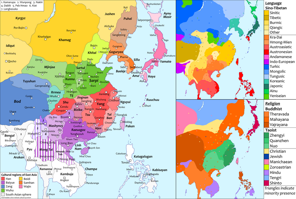
Map of India in the year 1960. The general idea is that the European powers were mostly unsuccessful at colonizing India beyond the coasts. This was due to a more powerful and united Mughal Empire which lasted until the mid 1800s.
It's a stronger anti-colonial defence that leads to... Sri Lanka being called Ceilan (Ceylon), a name which has its roots very clearly in colonialism.
 
It's a stronger anti-colonial defence that leads to... Sri Lanka being called Ceilan (Ceylon), a name which has its roots very clearly in colonialism.
I think it's plausible that a Sri Lanka which more effectively fended off Western colonialism would care less about correcting the Western exonym for their country – which, for what it's worth, passed from Sanskrit or Pali through Ancient Greek and Portuguese into English rather than being coined on the spot, and is derived from the same word that yielded "Sinhala" in that language. After all, it's not like China and Japan spend much energy trying to get Westerners to call them Zhōngguó and Nippon.
 
It's a stronger anti-colonial defence that leads to... Sri Lanka being called Ceilan (Ceylon), a name which has its roots very clearly in colonialism.
I figured that Sri Lanka would probably be colonized even if India was able to resist. Maybe there would be a way to avoid it, such as Europe being particularly weakened, or there were no attempts to colonize it. But for this map I decided it would be colonized by France, hence Ceilan, and is now independent.
 
Very nice. I am curious how Mongolia becomes Christian though.
Historically there had been a fairly sizeable Eastern Christian presence among steppe cultures, so that isn't too surprising to me. What I'm more interested in is that there appears to be a triangle signifying a Christian minority in Hokkaido. Was it meant to be Buddhist as with the rest of Japan or did Christian missionaries reach out to the Ainu at all here?
 
The last time I posted a map in a map thread was nearly a year ago. I'm definitely still making things!! I just tend to run out of energy before completing a product. So yeah, I thought I'd take the opportunity to post a few WIPs I have in my repository but will likely never finish. There's lots of lost in progress maps out there I'm sure so its' nice to occasionally dump the ol' map folder out and see what people have been doing in the background.

LqUq87m.png

This map is essentially my cover of Calbear's Anglo/American-Nazi War with a couple of twists. I was particularly inspired by the concept of the current debatable disintegration of American unipolarity occuring in the 70s/80s.

DLZupEb.png

This map was called "Fire/Ice" and I'm not sure if there was any particular world-building behind it. A post-apocalyptic America that is split between Canada (Ice) and Mexico (Fire).

pzc7HLO.png

This is as far as I got in a cover project for RoyalPsycho's Very Displaced. A few other mappers who took part in the same competition posted their completed products a while ago, I just never finished.
 
i kinda ran out of steam after quickly rebuilding a fair bit of the Dichotomy world map and i doubt i'll make any substantial progress before i go out of town, so i think i'll just share an updated version of it right now:
Dichotomy World Map.png

i was also able to find the easier "save as .png" method, so that helps ;) this is using mostly UCS and RCS colors, but i'm already starting to set up the "real" color scheme with a planned picture-in-picture feature that i'll be using in a few places, with the current example being the Greek states (not the whole Balkan Peninsula). the only real change to what was already on the earlier map is that i adjusted the borders of Marmarica, which i adjusted to look more like actual longitudinal lines. basically everything else is new. i'll list some of the biggest ones and the "keep an eye on this" parts:
  • no, that's not Mexico you see there--it's Anahuac, a revived Aztec Empire; the idea is that they were still defeated but not destroyed by the Spanish and this led to intermittent indigenous revolts up to the mid-19th century, where the Mexican-American War is replaced by the First Spanish-American War and there was a massive indigenous revival afterwards. i admit that i've gone to great lengths to contrive Anahuac's existence, but i've done too much work on creating a modern Aztec culture to turn back now ;) two simplified points on that is that "Aztec" in the modern period is a nationality, not an ethnicity, and they're actually much more moderate than the fact that they're Aztecs might suggest (namely, they don't practice human sacrifice anymore); generally speaking, i'm trying to avoid Mayincatec stereotypes as much as i can and only using them in a self-aware way if i can help it. this is probably a good time to mention that TTL is being written and designed more for its story and to create an interesting world rather than for diamond-hard plausibility.
  • Australia (and New Zealand, too) is currently shown in plain white partly because i'm still deciding what i'll be doing with it; this is partly because Code Geass is a major influence on TTL and i've recently decided to rewrite parts of TTL to strengthen the homage, which particularly includes an independent and neutral Australia, though part of me is reluctant to do so in part because i want Britannia (replacing the UK instead of being a carbon copy of the Holy Britannian Empire) to be very large geographically to help justify its superpower status (New Zealand is probably still going to be part of Britannia, though)
  • as implied earlier, Greece is disunited ITTL, inspired by my first learning of the proposed project to build Corinth Canal in Antiquity by chance and i've grown to realy like the ideas that stemmed from that; simply put, the area of OTL's Greece is multiple smaller states, the biggest being the Aegean League and the Athenian Republic with there also being Acarnania, Aetolia, Phocis, Ionia, and possibly Epirus, with an enlarged Macedonia overlapping with their territory. there's also a Thracian Republic which resulted from the area of European Turkey breaking off after the Rum Empire (replacing the Ottomans) fell apart.
  • Brazil doesn't have its borders yet, but will be recognizably similar with the "filler color" given there set to be chipped away as i define the rest of South America's geography instead, which--like IOTL--is going to be mostly Spanish; the most interesting thing about this one is that Brazil is actually Portugal in that, like IOTL, the Portuguese monarchy evacuated to South America when Napoleon showed up and, ITTL, they never left; the Portuguese state in Iberia is a more recent creation and the existing one changed its name to "Brazil" when it basically decided to not go back to Europe.
  • Darfur is independent; as yet, i haven't figured out much of what to really do with it, but i think part of it was ultimately because i decided that 9/11 didn't take place ITTL and that would cause the unfortunately oft-forgotten genocide in Darfur from around the same time to get more public attention
  • Egypt is a bit thinner but also longer, and has conducted the Qattara Depression Project, which is deliberately being written as a near-total SNAFU since they used nukes to create the canal flooding it, which not only irradiated the area itself but was also done when the sirocco winds were blowing, which in turn caused basically a radioactive sandstorm to hit the whole Aegean region and they were not happy about that.
  • that relatively big state around where Israel is located IOTL is supposed to be a Jordanian-Palestinian state, its geography being partly based on the Nabataean Kingdom; conversely, TTL's equivalent to Israel (not presently mapped) is based on the Uganda Plan and some other Jewish resettlement projects, partly as a consequence of World War II and the Holocaust not taking place.
  • that unbordered Russian Far East state is something i'm considered, and is named Kamchatka entirely to make a gratuitous reference to Risk :p this stemmed from a separate idea that Siberia could be independent, or at least autonomous to the point of being de facto independent, and this resulted in the Far East being cut off and gradually drifting away from the rest of Russia; it probably won't be shown in a solid color in the final version
  • Marmarica is an example of a new thing i'll be doing with North Africa in particular, by basing its borders on historical provinces along the coast instead of just directly paralleling OTL but for basically the same reasons (e.g., basically just arbitrary borders imposed by a bunch of white guys :p ); there's going to be at least five states like that in the region ITTL (not including currently-mapped Tunisia)
  • the bordered but uncolored area east of Iran is an early draft of "Pashtunistan", a rather obvious geographic equivalent to Afghanistan (it's possible it won't be using that name in the final version; part of my reason is that "Afghan" is mainly a national rather than ethnic term); anything i do here will be reliant on what i decide to actually do with Afghanistan ITTL--so far, it's just been a space-filling country
  • that big lump along the eastern Baltic is Teutonia, descended from the Teutonic State, as in part of the results of the Lithuanian Crusade. it's a bit of a cliche that the Baltic states are all lumped together, but my intention here is to use it to examine the realistic consequences of that
  • the big area in northwestern Africa is another "filler color" that i'll be taking pieces out of as i figure out what the real geography of the region looks like, the remaining part of it being a Tuareg Confederation as a modified version of the Azawad state that was originally going to be there
  • Turkey is being replaced by "Rumania", chosen for the legitimate reason of the Ottoman Empire being replaced by the Rum Empire (properly spelled as "Rûm") but also for the irony of Romania not existing ITTL but still being there ("Rumania" is a common historical spelling of "Romania"); like with Brazil and the Tuaregs, i haven't determined their proper territory yet in part because i'm planning to do a relatively extensive redesign of Near Eastern geopolitics, but they will mostly still be occupying the Anatolian Peninsula
  • a persisting Wallachia has been part of TTL for a long time, but it's recently become more important (originally it was just there for the "hey, look, this historical country is still around") by being the intended setting of a few narrative projects, but i only recently decided to add Moldavia to its territory as well (it's possible that i'll be redesigning that part of it slightly, either to add Bessarabia to it for replace Moldavia with that and something else is going on with Moldavia instead). part of the internal reasoning that it's "Wallachia" and not "Romania" is because the fictional ruling family, the House of Poenari, explicitly quashed alot of attempted unification movements to maintain power. Wallachia also maintains that it's the true successor to the Byzantine Empire and i'm planning to redesign their flag as well so that it fundamentally looks like their historical one but with a Byzantine coating. also, they reinvented Greek fire in the 18th century ;)
  • lastly, that West African state around the Niger Delta doesn't have a name yet (mainly because the notes that i have on it are pretty scattered) but is going to be relatively important to TTL, namely that it's actually the site of TTL's version of the Vietnam War, which in turn is partly modeled on the memetically crazy Nigerian Civil War, which is made even crazier ITTL by this being where weaponized mecha are first fielded. because yes, mecha exist ITTL :p i call them "cyclopses" ;) (before anyone says anything, the plural not being "cyclopes" is deliberate)
 
I did it. It was a nightmare, Hel it was madness but I finally did it.
I created my own color scheme.
This is not a definitive version, and I don't consider it complete (I'm particularly less than satisfied with South America and Africa) but here it is.
Thread to follow.
Feel free to ask me any questions.
ICS.png
 

Deleted member 108228


Believe me, I'm still asking myself the same question

Very cool, I like it!

What do you think of putting it together in some form of "classical" colour scheme (palette)?

Thank you. So far I have a HTML file with all the colors in hex format (as a web designer it's easier for me that way). The thread purpose is to convert it in a classical palette, but I suck at the more graphic part.
 
Top
Status
Not open for further replies.
Top