You are using an out of date browser. It may not display this or other websites correctly.
You should upgrade or use an alternative browser.
You should upgrade or use an alternative browser.
Map Thread XV
- Thread starter rvbomally
- Start date
- Status
- Not open for further replies.
Hey, I need a bit of help. I'm working on a map I made and got as far as an elevation map, but I'm stuck on the climate map.


Seraphiel
Banned
PoD - Le Pen won in 2017
The World's Top 10 Economies:
1. People's Republic of China
2. United States
3. German Federation
4. Eurasian Federation
5. Indonesia
6. Pakistan
7. Nigeria
8. Brazil
9. Japan
10. India
So ummm....
What happened to Europe? Franco-German War 2?
Divide and Conquer
Why isn't Aland independent?
Made a 11634 × 5848 version of the paradox-map by moxn (don't ask why)
https://drive.google.com/open?id=0B_r63V8x3ytPZldJNFdBZFB0Xzg
I plan on detailing it in the future by adding more lakes and islands as well as redoing parts of the coastlines.
Feel free to use it
https://drive.google.com/open?id=0B_r63V8x3ytPZldJNFdBZFB0Xzg
I plan on detailing it in the future by adding more lakes and islands as well as redoing parts of the coastlines.
Feel free to use it
How exactly did the death of the EU make Germany more powerful?
It made the Germans snap.
You won't like the Germans when they're angry.It made the Germans snap.
It's "Golfo", no "Gulfo".I MADE THIS AS WELL FOR THE 1815 MAP GAME
I remember making a similar experiment with X2 in QBAM. Was hard af.The Syrupy Waters of Hudson Bay prove difficult for regular ships to cross, and the land/syrup-locked nations around them rely on air and land for their goods.
You are making something amazing.
Sooo... is 'Berg op Zoom' is micronation/city state? wierd choicealso you know its actually Bergen op zoom right?
And are you only using the English names of towns seeing as you have Antwerp in stead of Antwerpen and Flushing in stead of Vlissingen? and I'm not sure Middlebrugh is the correct English name for MiddelburgI think its just the same as in Dutch... but I understand what you did
It's actually an exclave of a micronation comprise of the area around Brielle. And I do know it's Bergen op Zoom; but the micronation is an easter egg because the studentfolklore of my university is heavily based on the 'Geuzen' and one of our most important songs is 'Het Beleg van Berg op Zoom' so thats why I wrote it that way.
and I'm not using the English names, I'm using the local language of the Region/Country.... but Antwerp and surrounding areas and under the administration of the East India Company, so English is main language. And yes, I decided to anglicize Middelburg to Middlebrugh because.... why not
Vuru
Banned
mippity mappity
>Montenegro and Serbia both under Russian influence but separate
That's real fucking disgusting
And oh boy that Germany is asking to be dismantled
And oh boy that Germany is asking to be dismantled
Nah, it is asking for more expansion.
Heim ins Reich, Stettin.
Bytor
Monthly Donor
How big are the atmospheric circulation cells on the planet? They will decide the basics and the monsoon process & mountain ranges will decide the rest.Hey, I need a bit of help. I'm working on a map I made and got as far as an elevation map, but I'm stuck on the climate map.
View attachment 310194 View attachment 310195
Because your mini-continent goes from about 13°S to 39°N it will be mostly under your planet's equivalent of Hadley cells and winds tend to blow towards the equator and to the west (assuming your planet spins in the same direction as Earth). Generally the eastern side of the continent will be lush and green and on the other side will mostly drier thanks to mountains except along the coast where the monsoon-process will make things wetter again.
Because the general trend of winds will be towards the west that will work to keep any monsoon-process effects close to the coast and not push overly far inland. How far they do get inland will define how far west from the mountains the deserts reach and how wide the bands of desert→prairies→savanna will be. High mountains like the Himalayas means more moisture dropped as rain before crossing which means bigger rain shadow deserts, bigger prairies and smaller savannas because of the relatively abrupt change in precipitation as you go inland towards the east.
Smaller mountains like the Appalachians will mean more moisture retained to fall on the other side reducing the deserts and increasing the savanna because precipitation does not fall off quite as abruptly.
If the mountains are lower like the Appalachians, the east coast will still be rainy and green but there will still be enough moisture in the air so there won't rain-shadow deserts as well as some savanna in between the coast forests and narrower inland prairies for much less abrupt transition.
Because so much of the planet is ocean allowing the winds to pick up a lot of moisture that eastern side of the mountains is going to be significantly rainier than the rainiest spots on Earth
The exceptions to this general pattern will be the extreme north and the extreme south of the continent. In the south with the lack of mountains, will not be as excessively rainy as the east coast and the main driver of precipitation will be the monsoon process, so probably a lot like the Malaya peninsula and solid tropical forest. The northwest, north of that big lake, will probably be in the equivalent of the "Horse latitudes" between the Hadley and Ferrel cells. Relatively calm and not very windy and at the centre of a near-permanent high pressure zone so winds will tend to be from land to the oceans. However, that high pressure zone will not be as forceful as the generally trending towards the west winds further south so the mitigation of the monsoon-process effects will not be as strong so the whole area will be patchy forests and grass based more on local geophysical conditions like soil drainage, rocky outcroppings and so on, sort of like Indiana and Illinois to but warmer during the winter and no tornadoes.
https://en.wikipedia.org/wiki/Atmospheric_circulation
https://en.wikipedia.org/wiki/Monsoon#Process
My first post on the forum, and my second dabble into AH maps. Going with the idea of being a trend setter, here's an idea I had. A map series of alternate version of OTL countries in worlds where they are analogous to the United States. I will attempt to keep posting until all the countries are complete. Here's the first country- Albania, or as it's called in it's universe, The United States of Albania.
This is a world where Albania managed to centralize and successfully fight off Ottoman rule, centralizing into a democracy and managing to take a good portion of the Balkans, eventually pushing into North Africa as the Ottoman empire continued to destabilize. It's suffering from a wave of Catholic terrorism and Illegal immigration from the Osmanli Sultanate.

Yeah so a bit ambitious and wanktastic but I plan to see it through. Tell me what you think. I'm doing Andorra next (Andorra is admittedly, kinda hard to turn into a US analogue, so suggestions would be appreciated)
Hey I really like this idea, especially since I've actually been working on a very similar concept for a map (only with South Africa instead of Albania as the USA analogue).
I'm wondering, however, in this country wouldn't most of the citizens be Egyptian and *Iraqi? How would they feel about still not having independence? I would imagine the original Albanians that the country is named after would be a smaller minority.
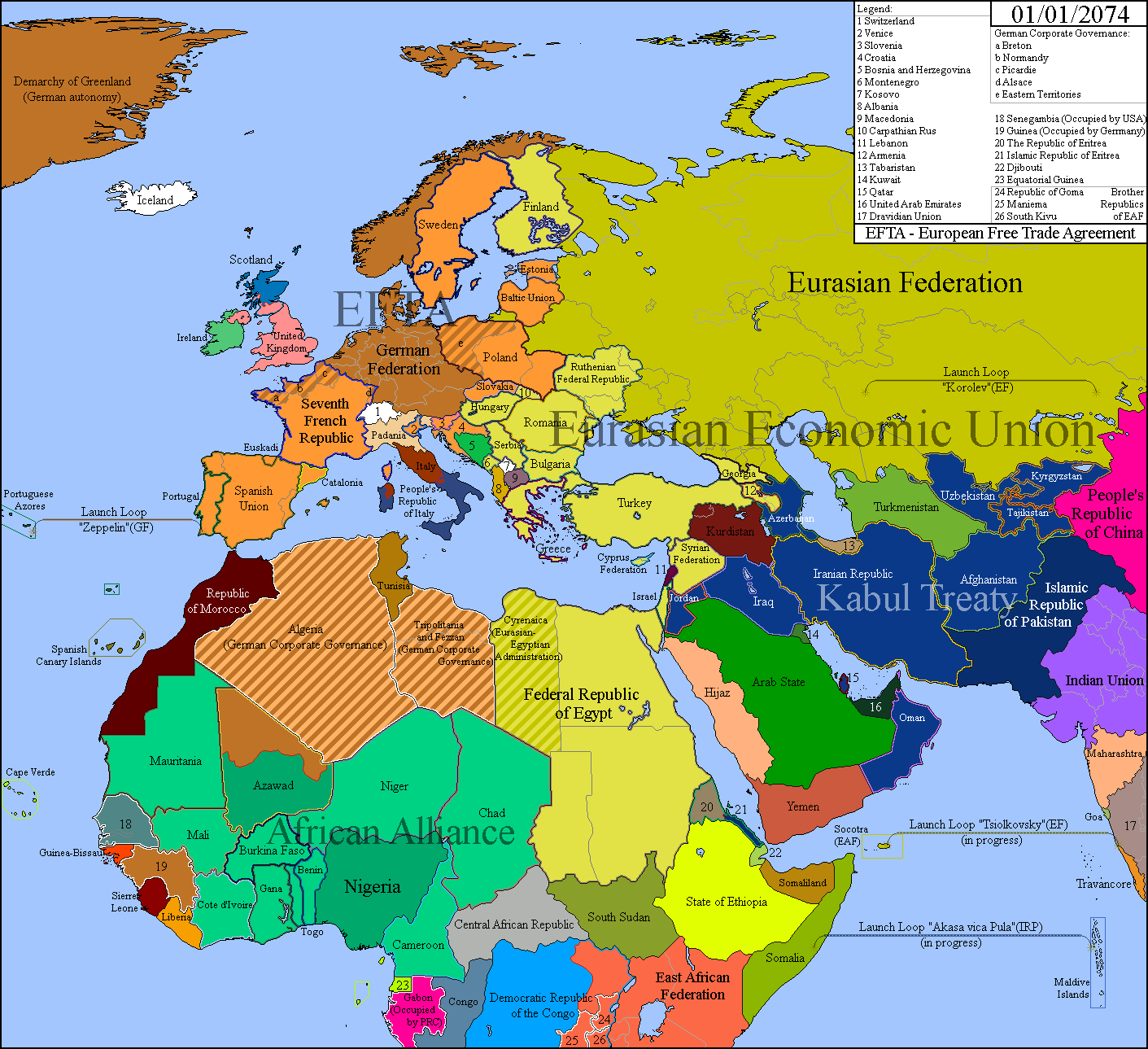
Another part of my world more or less done. Any questions? (Yes, I did get a lot of inspiration from real life)

1) Scottish War for Independence (?)snip
2) Those Launch Loops in Socotra, Balkanized India, Somalia and the Maldives
3) Great Azerbaijan
4) Iran with no Tehran
5) Gabon Occupied by China.
6) Chaos in Italy
7) Splited Uzbekistan (It's Pro-Eurasian in OTL)
8) Senegambia Occupied by the US
9) West Ukraine changes his name to Ruthenia
10) Carpathia under Eurasian influence
11) Eurasia with South Ossetia but no Abkhazia.
Serafim hates everything right now.
Iran still has Tehran, it looks like.1) Scottish War for Independence (?)
2) Those Launch Loops in Socotra, Balkanized India, Somalia and the Maldives
3) Great Azerbaijan
4) Iran with no Tehran
5) Gabon Occupied by China.
6) Chaos in Italy
7) Splited Uzbekistan (It's Pro-Eurasian in OTL)
8) Senegambia Occupied by the US
9) West Ukraine changes his name to Ruthenia
10) Carpathia under Eurasian influence
11) Eurasia with South Ossetia but no Abkhazia.
Serafim hates everything right now.
- Status
- Not open for further replies.
Share: