Map Thread X

Status
Not open for further replies.
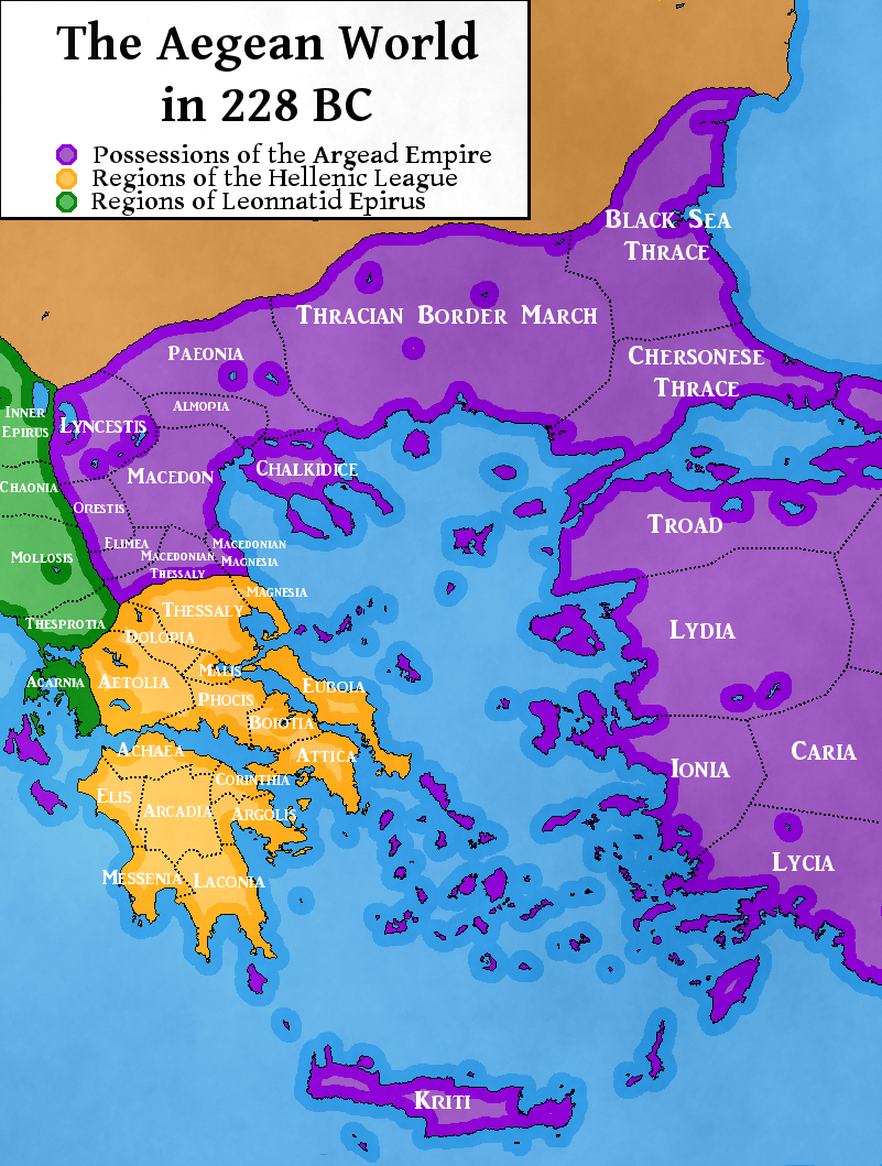
Seems like I'm plugging this too much but here it is with notes for the rest. If you think I've missed out interesting areas, tell me.

One thing I would point out is that the key seems backwards.
Maybe I'm just too used to "Colour Square - Definition" rather than "Definition - Colour Square"
 
One thing I would point out is that the key seems backwards.
Maybe I'm just too used to "Colour Square - Definition" rather than "Definition - Colour Square"
I would also make the color squares line up, and perhaps generally just tidy up the legend a bit. Perhaps creating outlines around the blocks, so it's easier to see who likes who?
 
I seriously neglected a timeline here due to heavy university work. In part recompense, and with a view to a possible reboot, here is a map relating to it.

The names of the various regions in this map mostly follow anglicisations to avoid confusion, where there are 'named' regions I've translated into English.

aegean_228_bc_by_daeres-d5g80wh.png

This pleases me
 
I seriously neglected a timeline here due to heavy university work. In part recompense, and with a view to a possible reboot, here is a map relating to it.

The names of the various regions in this map mostly follow anglicisations to avoid confusion, where there are 'named' regions I've translated into English.

1) YES!

2) Could I trouble you for that basemap?
 
I seriously neglected a timeline here due to heavy university work. In part recompense, and with a view to a possible reboot, here is a map relating to it.

The names of the various regions in this map mostly follow anglicisations to avoid confusion, where there are 'named' regions I've translated into English.

aegean_228_bc_by_daeres-d5g80wh.png

Cool map. Is it all original or based off another?
 
The basemap is not mine, the borders are extrapolated from the actual borders of various Greek regions, though some of the borders of Epirus are altered because TTL Epirus is larger than OTL. The Argead satrapies in Thrace and Asia Minor are partially extrapolated from real regions, and also the increase in the number of satrapies compared to the Achaemenid Persians.
 
Well the land bordering California is either ostensibly the Navajo, or the delightfully named Brownland, a land of fiery preachers and Christian beliefs flavoured with Native American bits.

I'm surprised nobody has started to pick apart at it, given the mineral resources there in OTL Colorado, Nevada, oil bearing parts of Texas, etm.)
 
I'm surprised nobody has started to pick apart at it, given the mineral resources there in OTL Colorado, Nevada, oil bearing parts of Texas, etm.)

As more people move into the country, so the neighbouring states, especially newly unified Nuevizcaya are going to be looking with a great deal of interest. And America isn't going to stay as a pastoral yeoman paradise forever...

Glad to see it wasn't just me.

Daw...:eek:
 
its an ISOT map Some nations have Lost land to others And Saudi Arabia has Unified under a different Ruler in their Timeline which eventuall elad to a founding of a Stable Arab Federation it is Not Greater Egypt
 
Why would the UAE join a union with Oman?

Why are Israel and Lebanon together? With the West Bank and Gaza, without the Golan Heights?

Why are B&H and Serbia together?

How did Russia annex the Caucasus?

Canadian Greenland?

Okay, I'm done...though I will point out that Socotra should probably be part of your Caliphate
 
Top
Status
Not open for further replies.
Top