Map Thread V

Status
Not open for further replies.
Minus one point for the Monty Python reference.
Minus one point for lying (this is not, by any stretch of the term, completely different).
Minus one point for doing an idea that someone else has already done better.
Minus one point for misspelling "different".
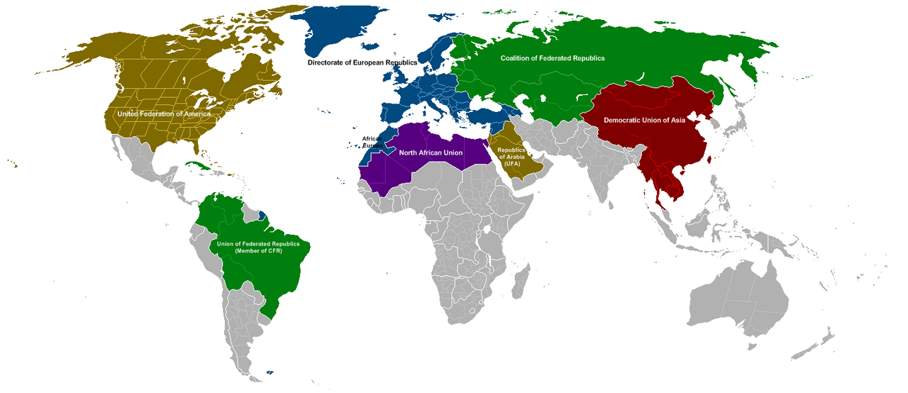
Minus one point for the use of space filling empires.
Minus one point for the use of anachronistic OTL borders.
Minus one point for the overuse of that base map.
Minus one point for using "anglo" as an adjective instead of a prefix.
Minus one point for the total lack of a proper explanation or description of the world.

Following Cartographical Standards Control Department policy, your license to create maps has been revoked. Please turn in your map license, your your immortal soul, and all of your own blood to your local Cartographical Standards Control Officer. Failure to comply with this order is a criminal offence, and the CSCD will acquire a warrant to forcibly remove your license, soul, and blood if needs be. If you wish to apply for another map license at a later date then it sure sucks to be you, buddy.

I hate my life :(:(:(:eek::(:(:(:eek::(:(:(

1.Has some one already done a stempunk 1984?

2. Space Filling Empires are the point Dumkopff!

3. Quite Frankly, i have acctualy never seen any Monty Python (a rareity among British Empire Patriots), so any referances are completely coincidence.

4. The idea came from a seires of stories i did ages ago which i dug up from the deep dungeons of my documents and i didn't realy want to bore people to death.

5. OTL Borders come from the Fact that the POD is in the 1880's (Althoguh i agree that border with Angola is very annoying come to think of it).

6. How would you like me to do my maps in the future if any at all?
 
To do one or two or even three of these things is an act of idiocy, but to manage to put all of them in a row, well, takes skill and may even be an art onto itself. we may have the AH version of "Plan 9 from outer space"...
...No.

At least a third of all the maps in the Map Thread do one or two or three of these things. I'd say at least a fifth of the maps in the Map Thread do all. And most, like this, have a grain of merit behind them. Spitfire's has been done before, yes, but not often, and never in the way he's done it.
 
I hate my life :(:(:(:eek::(:(:(:eek::(:(:(

1.Has some one already done a stempunk 1984?

2. Space Filling Empires are the point Dumkopff!

3. Quite Frankly, i have acctualy never seen any Monty Python (a rareity among British Empire Patriots), so any referances are completely coincidence.

4. The idea came from a seires of stories i did ages ago which i dug up from the deep dungeons of my documents and i didn't realy want to bore people to death.

5. OTL Borders come from the Fact that the POD is in the 1880's

6. How would you like me to do my maps in the future if any at all?
Analytical Engine is the only one I can think of who made one. He called his "1884" as well.

Africa's the main problem. Nearly all African borders were decided from 1884 on.


And don't hate your life. Krall's just being Krally.
 
1.Has some one already done a stempunk 1984?

I'm not sure about that, however the point is that posting a random map and saying it's steampunk does not make it steampunk. It's difficult to portray something steampunk-y on a map only, so you have to either be rather creative or provide an explanation as to how the world came to be like that to prove that it is definitely steampunk.
 
Look eveyone, it looks like i have some explaining to do. Firstly, the fact i created this map was an urge i got from digging up a series of stories i did which could pretty much be described as a Stempunk, Victorian 1984, so sorry about that. Secondly, i turly have never seen any Monty Python at all, so the referance there is coincidnece. Thirdly, I have a life and i don't go through the map threads all day looking for Steampunk 1984 maps. Fourthly, i ahve never seen Analytical Engines 1884 map. So there... Happy Krall :mad::mad::mad:
 
Straight to the point:

2019. A massive asteroid barrage impacts the Northern Hemisphere (Arctic Ocean - Atlantic Ocean). Millions of lives lost. Trillions of dollars lost.

In 7 years time, the world has vastly changed. The asteroid remains contain several thousand tons of Helium Isotope-3. A few kg of Hi3 can power NYC for months on end. Imagine the craving for this new power source. Generic AltHistory shit happens, like the breakup of NATO and the UN.

Here's the map, year 2029 A.D. :

2_029__by_DireSituation.png


NOTES:
- The United Federation of America is not a result of the USA invading Canada. Canada was devastated by the barrage and formed a Military/Free Economic Pact with the USA. Both countries are still sovereign - the UFA is merely a powerful organization.

- The North African Union is quite unique. After the 2021 Egyptian Revolution, Libya and Algeria followed, and formed a union with goals that are not religious, but purely scientific. The NAU has quite a lot of land after desert reclamation- turning the lifeless Sahara into a fertile plain.

- The Republics of Arabia are the result of UFA control over them. After the Arabian War of 2023-2024, the Former Saudi Arabia was split into East and West Administrations, due to heavy guerrilla activity in the region.

- The Democratic Union of Asia is a command-Capitalist military organization, initiated by the PRC. In 2026, the King and Prime Minister of Thailand, and many government officials were assassinated by unconfirmed assassins, and the DUA (Which at the time composed of the PRC, Vietnam, Myanmar, and Laos) invaded and annexed the in-chaos nation. This was not a spur of the moment annexation. As of 2029, large amounts of civil unrest in Thailand still exist.

- The Directorate of European Republics is basically a military expanded pact of the EU. For the first time in history, Switzerland broke its neutrality as the capital of the DER (Geneva, specifically), since many other European nations were near collapse after the massive asteroid barrage. African Europa came after a proxy war with the then-emerging North African Republic.

- Can anyone get me a better basemap? Specifically, a Robinson Projection of the whole world without this overused basemap?
 
Last edited:
...No.

At least a third of all the maps in the Map Thread do one or two or three of these things. I'd say at least a fifth of the maps in the Map Thread do all. And most, like this, have a grain of merit behind them. Spitfire's has been done before, yes, but not often, and never in the way he's done it.

I know, I was just trying to annoy Krall. I have a couple of questions though.

1) If you guys think UCS is so annoying, why did you come up with it in the first place and even dedicated a thread or two to further develop it?
2) what's a "krall" anyway?
 
Doesn't matter - Nova Scotia wasn't Lower Canada ever and had its own name. It's like if South Carolina became independent and the US decided to rename Georgia "South Carolina". It's crazy and makes no sense.

They're both still part of Canada (it's a Pakistan-type situation). And are Nova Scotia, Prince Edward Island, and New Brunswick traditionally called Nova Scotia as a whole?

Bruce
 

Krall

Banned
1) If you guys think UCS is so annoying, why did you come up with it in the first place and even dedicated a thread or two to further develop it?

I blame Thande. No, seriously; he designed the UCS.

That said, I don't particularly dislike the UCS.

2) what's a "krall" anyway?

A Krall is a monstrous blight on this world; an unimaginable being composed of pure hate.

It's also a username I started using several years ago because I thought the word sounded cool. More recently, though, I've started using the username "King Awesome II" for anything new I join.
 
They're both still part of Canada (it's a Pakistan-type situation). And are Nova Scotia, Prince Edward Island, and New Brunswick traditionally called Nova Scotia as a whole?

Bruce

No, they're both still part of British North America. Before 1867 "Canada" means the St Lawrence watershed, basically. (And to the second question: yes before 1784, although your POD is after that so "the maritimes" might be a better name.)
 
By Timothy Robinson, age 9

Part of my previous 2029 map.

North_African_Union_Report_by_DireSituation.png


North_Africa_and_Africa_by_DireSituation.jpg


(Outdated 2027 Map. Refer to Above Post for Current 2029 Map)
 
Last edited:
Top
Status
Not open for further replies.
Top