Zagan
Donor
Theory (please read)
We all know the feeling of seeing that damned Kazakh border (TM) or something similar unexpectedly showing up in an otherwise good and interesting TL.
While the noobs produce such horrors constantly, even the best of us do sometime err in this regard, obviously with less known borders.
The damned Kazakh border error could be defined like this:
In a TL having a POD in year X we have a border which (1) is identical to an OTL border created in later than X and (2) does not follow some obvious geographic landmark like a river or mountainous continental divide (in which second case the border would be obviously acceptable).
The problem is that we do not usually know the age of a certain border.
The age of a border is a complicated matter. Let's try to define it:
The age of a border is the earliest time in history when any border was lying in that particular location, even if (1) the border was subsequently removed or (2) the border used to delimit different countries or (3) it was not an international border but only an (important) internal subdivision.
Examples:
1. The Western segment of the border between Russia (Kaliningrad Oblast) and Lithuania.
Age: 1919 (Memelland was split from East Prussia).
Exception: As it lies on an important river (Neman) it could be used, even with a pre-1919 POD.
2. The Eastern segment of the border between Russia (Kaliningrad Oblast) and Lithuania.
Age: 16th Century (as part the border between Ducal Prussia and Lithuania).
Observation: The fact that today, on the Southern part of the border, instead of Prussia or Germany lies Russia does not affect the age of that border.
Mistake: Using it with a Roman POD as a border between Rome and Sarmatia.
Correct: Using it as the border between Poland and the Soviet Union with a POD of 1920.
3. The Pruth border between Romania and Moldavia.
Age: 1812 (Russia annexation of the Eastern half of the Principality of Moldavia)
Observation: The fact that the border disappeared between 1918 - 1940 and between 1941 - 1944 does not make it any younger than 1812.
Correct: Using it as the border between Romania and Russia with a POD of 1919 (even though the border did not exist in 1919, it used to exist in the past and could be recreated, as it actually happened in OTL).
What should we do then when writing a TL or drawing a map for a TL?
Variant 1: Scrupulously research each and every border used (could be very time-consuming).
Variant 2: Do not care and hope that nobody would object to any anachronistic borders.
Variant 3: Do not use any OTL borders (that is clearly absurd as many borders are there for a reason).
Variant 4: Quickly consult a single centralized database (adnotated map) containing the ages of every border segment.
Well, Variant 4, surely! Please give me a link to that miraculous database / adnotated map!
Sorry, it does not exist... yet.
But you could help create it.
So, may I introduce you the Borders Age Map(s)...
Definition: A Border Age Map is a blank map showing only the borders with adnotated Border Ages for each border segment (between tripoints or segment markers).
Example:

That's good, but why don't you do this for all the borders in the World? Why do you need the help of the community?
Well, for two reasons:
1. It is a monumental task which should help all of us.
2. I do not have access to enough information about all the borders. It was rather easy to do Romania (my country), but I know much less about Paraguay for example.
And now the basemaps without the age adnotations (I will keep adding them and I hope that I would get some help in this huge endevour).
Note: Click on the Thumbnail for the Full-size version (middle-click to open in a new tab).
Europe and the Mediterranian
From Google Maps Zoom 6 (better quality, without Northern Scandinavia):

And Google Maps Zoom 5 if you prefer the same scale as the other maps:

Asia
From Google Maps Zoom 5:

Africa
From Google Maps Zoom 5:

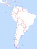
Latin America
From Google Maps Zoom 5:

USA and Canada, with Subdivisions
From Google Maps Zoom 5 (without the extreme North):

Australia, with Subdivisions
From Google Maps Zoom 5:

Note: I cannot upload the full world map because (1) it is several megabytes in size and (2) its resolution (8192 x 8192 pixels) makes it rather difficult to work with. I can paste the end results of our work together and upload the full map to an Internet Image Host like imgur or postimage.
Note: In order for the final map to look uniform, please:
1. Do not change any colors, borders, coastlines, etc.
2. For text, use the Font Calibri, Size 10, Normal, Black, Anti-aliased.
3. For the segment dividers, use Width 1 pixel, Black, Anti-aliased.
4. Save as PNG 8 bit per pixel and optimize with a PNG Optimizer (for example optipng.exe).
5. If the file size gets bigger than 500 KB, crop the part you had modified (I will take care of it).
6. Post here. Thanks.
Now I will start working on this and will post the partial results here from time to time.
If someone wants to contribute, please volunteer here stating the area of expertise (in order to avoid duplicating work).
Come on: Do once, benefit for ever!
Thank you.
CONTRIBUTORS:
@Zagan: Concept, Blank Maps, will do (parts) of Europe.
@Falkanner: Most of Latin America.
@Narwhal: Australia.
@telynk: Could do parts of North America.
@Tallest Skil: Useful information.
@Mav12: Useful information.
@Stuyvesant: Ecuador.
@XO Mapping: Good idea.
Waiting for more...
We all know the feeling of seeing that damned Kazakh border (TM) or something similar unexpectedly showing up in an otherwise good and interesting TL.
While the noobs produce such horrors constantly, even the best of us do sometime err in this regard, obviously with less known borders.
The damned Kazakh border error could be defined like this:
In a TL having a POD in year X we have a border which (1) is identical to an OTL border created in later than X and (2) does not follow some obvious geographic landmark like a river or mountainous continental divide (in which second case the border would be obviously acceptable).
The problem is that we do not usually know the age of a certain border.
The age of a border is a complicated matter. Let's try to define it:
The age of a border is the earliest time in history when any border was lying in that particular location, even if (1) the border was subsequently removed or (2) the border used to delimit different countries or (3) it was not an international border but only an (important) internal subdivision.
Examples:
1. The Western segment of the border between Russia (Kaliningrad Oblast) and Lithuania.
Age: 1919 (Memelland was split from East Prussia).
Exception: As it lies on an important river (Neman) it could be used, even with a pre-1919 POD.
2. The Eastern segment of the border between Russia (Kaliningrad Oblast) and Lithuania.
Age: 16th Century (as part the border between Ducal Prussia and Lithuania).
Observation: The fact that today, on the Southern part of the border, instead of Prussia or Germany lies Russia does not affect the age of that border.
Mistake: Using it with a Roman POD as a border between Rome and Sarmatia.
Correct: Using it as the border between Poland and the Soviet Union with a POD of 1920.
3. The Pruth border between Romania and Moldavia.
Age: 1812 (Russia annexation of the Eastern half of the Principality of Moldavia)
Observation: The fact that the border disappeared between 1918 - 1940 and between 1941 - 1944 does not make it any younger than 1812.
Correct: Using it as the border between Romania and Russia with a POD of 1919 (even though the border did not exist in 1919, it used to exist in the past and could be recreated, as it actually happened in OTL).
What should we do then when writing a TL or drawing a map for a TL?
Variant 1: Scrupulously research each and every border used (could be very time-consuming).
Variant 2: Do not care and hope that nobody would object to any anachronistic borders.
Variant 3: Do not use any OTL borders (that is clearly absurd as many borders are there for a reason).
Variant 4: Quickly consult a single centralized database (adnotated map) containing the ages of every border segment.
Well, Variant 4, surely! Please give me a link to that miraculous database / adnotated map!
Sorry, it does not exist... yet.
But you could help create it.
So, may I introduce you the Borders Age Map(s)...
Definition: A Border Age Map is a blank map showing only the borders with adnotated Border Ages for each border segment (between tripoints or segment markers).
Example:
That's good, but why don't you do this for all the borders in the World? Why do you need the help of the community?
Well, for two reasons:
1. It is a monumental task which should help all of us.
2. I do not have access to enough information about all the borders. It was rather easy to do Romania (my country), but I know much less about Paraguay for example.
And now the basemaps without the age adnotations (I will keep adding them and I hope that I would get some help in this huge endevour).
Note: Click on the Thumbnail for the Full-size version (middle-click to open in a new tab).
Europe and the Mediterranian
From Google Maps Zoom 6 (better quality, without Northern Scandinavia):
And Google Maps Zoom 5 if you prefer the same scale as the other maps:
Asia
From Google Maps Zoom 5:
Africa
From Google Maps Zoom 5:
Latin America
From Google Maps Zoom 5:
USA and Canada, with Subdivisions
From Google Maps Zoom 5 (without the extreme North):
Australia, with Subdivisions
From Google Maps Zoom 5:
Note: I cannot upload the full world map because (1) it is several megabytes in size and (2) its resolution (8192 x 8192 pixels) makes it rather difficult to work with. I can paste the end results of our work together and upload the full map to an Internet Image Host like imgur or postimage.
Note: In order for the final map to look uniform, please:
1. Do not change any colors, borders, coastlines, etc.
2. For text, use the Font Calibri, Size 10, Normal, Black, Anti-aliased.
3. For the segment dividers, use Width 1 pixel, Black, Anti-aliased.
4. Save as PNG 8 bit per pixel and optimize with a PNG Optimizer (for example optipng.exe).
5. If the file size gets bigger than 500 KB, crop the part you had modified (I will take care of it).
6. Post here. Thanks.
Now I will start working on this and will post the partial results here from time to time.
If someone wants to contribute, please volunteer here stating the area of expertise (in order to avoid duplicating work).
Come on: Do once, benefit for ever!
Thank you.
CONTRIBUTORS:
@Zagan: Concept, Blank Maps, will do (parts) of Europe.
@Falkanner: Most of Latin America.
@Narwhal: Australia.
@telynk: Could do parts of North America.
@Tallest Skil: Useful information.
@Mav12: Useful information.
@Stuyvesant: Ecuador.
@XO Mapping: Good idea.
Waiting for more...
Last edited:
 I think I'll still add lines and dates but won't upload anything until I change the font to Calibri
