You are using an out of date browser. It may not display this or other websites correctly.
You should upgrade or use an alternative browser.
You should upgrade or use an alternative browser.
Map Thread XI
- Thread starter Pragmatic Progressive
- Start date
- Status
- Not open for further replies.
I'm actually pretty upset no one got the joke.
Look at the colors.
Canada = Sweden?
Wisconsin = Denmark
Denver = Russia
Kansas-Missouri = Poland-Lithuania
Mexicans = Ottomans
Miama = Venice
Florida = Italy
Dixie = Austria
Holy American Empire = HRE of the German Nation
Ohio = France
Chicago = Netherlands
Boston = Portugal
New York = Spain
Arizona = ???
California = Terra Nullius
There. I got your joke(s).
My experiment with map textures.
So.... Ohio is France, Florida is Italy, Holy American Empire is Holy Roman Empire, Superior is Britain, Texas is the Ottoman, NY is Spain, Canada is Sweden, which makes current USA the Roman Empire. Oh, and the Republoc of Miami is Venice.
They do have some future enemies in common so it's not like cooperation between the two would be entirely impossible or anything. I'd expect Venice to abandon any alliance like that as soon as a favourable opportunity to do so presents itself though.
That would give the Venetian a fame of treacherous slime in the eyes of the Milanese, that may come later as the base for a bitter enmity. Good Luck when the Habsburg come.
Hm, wasn't the favourable relationship between the Papacy and Florence something with its roots in the later period (mid-1430s and up at least) of Medici supremacy in Florence? Or did it start earlier than that?
AFAIK Florence was a Guelf city (that is on the papal side) as far back as Dante Alighieri was young, meaning late 1200-early 1300. If anything, there have been several internal disputes within the papist side, even leading to civil wars.
Added ArizonaCanada = Sweden?
Wisconsin = Denmark
Denver = Russia
Kansas-Missouri = Poland-Lithuania
Mexicans = Ottomans
Miama = Venice
Florida = Italy
Dixie = Austria
Holy American Empire = HRE of the German Nation
Ohio = France
Chicago = Netherlands
Boston = Portugal
New York = Spain
Arizona = Mongols
California = Terra Nullius
There. I got your joke(s).
")
A little map of the Latin Empire, Baldwin II reconquered Greece with the help of Charles I of Naples (, Albania, Africa and Thessalonica). The latter was the strong man of the empire till he died. The major players are now Charles II of Naples, the Knights of St. John who are nominaly vassals of King Robert I of Africa (Charles II' brother), King John II of Cyprus and the Venetians who own a bunch of islands, who are nominally part of the Latin Empire.

A little map of the Latin Empire, Baldwin II reconquered Greece with the help of Charles I of Naples (, Albania, Africa and Thessalonica). The latter was the strong man of the empire till he died. The major players are now Charles II of Naples, the Knights of St. John who are nominaly vassals of King Robert I of Africa (Charles II' brother), King John II of Cyprus and the Venetians who own a bunch of islands, who are nominally part of the Latin Empire.
Nice. Have the Ottomans been butterflied? Otherwise they'll be giving the Latins some grief afore long...
Bruce
Krall
Banned
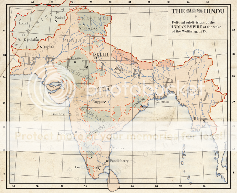
My first attempt at a vector-based map as perfected by Blomma.
Not much of a PoD, besides Afghanistan being connected more closely to the Raj and Germany winning the Great War
That looks great!
I have a few things to note, though: the red borders look a bit weird in places (mainly around Afghanistan, where it looks like there's a bright red dotted line on a dark brown/red line), and it appears that the borders of the map are showing through Sri Lanka at the bottom.There's also something strange with the text in some places. There are a few places where text overlaps where it doesn't need to (like where "British Raj" overlaps with "Burma", or "Orissa" overlaps with "Cuttack", or "Jubbulpure" overlaps with "Central Province"), which makes it look rather messy. The several different sizes, opacities, and typefaces of the names of the different provinces, presidencies, and princely states seem very inconsistent. And the labels on the ocean are much paler than they need to be - they aren't near any other more important text, and making them a bit more opaque shouldn't distract from the more detailed and colourful land.
So, yeah. You've got the look and the style down - you just need to work on some of the details.

This (still unfinished) map was originally going to be my MotM entry, but since then I have came up with a better idea.
Basically, In 1962 the Pied Noirs (with the help of the French Foreign Legion and OAS) manage to establish a nation in Western Algeria after negotiations to peacefully partition Algeria between the natives and settlers fail.

Basically, In 1962 the Pied Noirs (with the help of the French Foreign Legion and OAS) manage to establish a nation in Western Algeria after negotiations to peacefully partition Algeria between the natives and settlers fail.
A WIP of the southern portion of the Salterian Continent just before it's discovery by Cristobal Colon.
The Magenta country is the Empire, comprised of nine Kingdoms united under fealty to the King of the Kingdom of Mesico. The nine Kingdoms are: Mesico, Oskan, Thumbri, Warde, Pardisia, Northend, Maya, Costa, and Corne.
The Greenish nation is the Island Federation of Platonia, a power that controls the seas and is ruled by the Platos People who have an illustrious slave trade.
The Maroon nation in the Southern Continent is a horde empire of the Dar-Kri.
Slightly based on Game of Thrones.
This (still unfinished) map was originally going to be my MotM entry, but since then I have came up with a better idea.
Basically, In 1962 the Pied Noirs (with the help of the French Foreign Legion and OAS) manage to establish a nation in Western Algeria after negotiations to peacefully partition Algeria between the natives and settlers fail.
Looks nice, R. (Artistically rather than situationally: much ethnic cleansing was involved, I'd assume.)
Anyone have any comments on my map for Chipperback before it vanishes into the previous page?
Bruce
Whoops, didn't quote BMunro. Oh well. Very well done map. What's the deal with the land-of-improbably-straight-lines? and why are the borders different on the other map? How does north American politics work? seems like it would be pretty complicated, or else maybe in an EU-sort of thing. I mean, they do have the same cultural background/history of common governance. Overall another excellent map.
Maps before and after the 1965 Sino-Tibetan War from my TL.
Awesome; this means there's an update! Must go read.
I'm actually pretty upset no one got the joke.
Look at the colors.
Thats actually pretty clever and I'm pretty happy I picked up on it eventually.
- Status
- Not open for further replies.
Share: