You are using an out of date browser. It may not display this or other websites correctly.
You should upgrade or use an alternative browser.
You should upgrade or use an alternative browser.
The M-BAM Main Thread
- Thread starter Pogoboy20
- Start date
In fact, it could be called the AlternateHistory.com Projection.
We might as well find out the exact problem with it and adjust other maps with whatever percentage we're off from Robinson thereof. No chance really to convert MBAM to another type of map, not without another year of work.
We might as well find out the exact problem with it and adjust other maps with whatever percentage we're off from Robinson thereof. No chance really to convert MBAM to another type of map, not without another year of work.
I did that already. The basic problem is...
Hawaii should farther west.
The Americas are more or less fine. same for Greenland and Iceland
Atlantic should be a bit wider.
Africa should be a bit more east; the Madagascar strait is also too narrow.
Europe should be a bit more east.
Asia generally should be much wider. This is especially noticeable in Siberia.
India, Japan, China, Indonesia, Australia should be much more east.
Antarctica not should really extend quite as far north as it does in the Indian Ocean region.
Additionally, the overall shape is somewhere between Kavraiskiy-7 and Wagner-6; the ratio of the equator length and pole line length is correct for both, but the x:y aspect ratio is somewhere between the two.
http://ashtagon.deviantart.com/art/The-QBAM-is-wrong-637548686
(yes, I know the altitude map I overlaid is a raised water level map; I was still in the early stages of figuring stuff out. However, it still demonstrates the key point that Eurasia needs to be wider and the far east farther east).
Most times I raise this issue though, someone inevitably says qbam/mbam is accurate enough for a-h purposes, or that we've already invested too much time making this inaccurate version to redo and switch to an accurate version.
Last edited:

Why don't we just accept that MBAM is an artistical interpretation of the world which is mainly designed for people making sci-fi/fantasy scenarios (as AH is de facto fantasy)
This is how M-BAM and Robinson look like in comparison if you just stretch the whole M-BAM to match Robinson
It isn't too awfully far off, is it?
(Antarctica isn't Robinson though it seems)
I dunno man. The frequency of those image flips very nearly triggered a petit mal in me.
Yeah, it's like saying the Russia color for a color scheme is wrong because it's too gr-Why don't we just accept that MBAM is an artistical interpretation of the world which is mainly designed for people making sci-fi/fantasy scenarios (as AH is de facto fantasy)
...oh.
I did that already. The basic problem is...
Hawaii should farther west.
The Americas are more or less fine. same for Greenland and Iceland
Atlantic should be a bit wider.
Africa should be a bit more east; the Madagascar strait is also too narrow.
Europe should be a bit more east.
Asia generally should be much wider. This is especially noticeable in Siberia.
India, Japan, China, Indonesia, Australia should be much more east.
Antarctica not should really extend quite as far north as it does in the Indian Ocean region.
You forgot Fiji, the southern islands should be more east, but then there is no space anymore for Tonga (I had this problem last year)
Mapping art need in realistic maps because serious inaccuracies in base map lead to loss of accuracy that is necessary for work with a high level of detail elaboration. Minor inaccuracies such as an inconspicuous discrepancy Robinson's projection is pardonable but serious distortions lead to a catastropheWhy don't we just accept that MBAM is an artistical interpretation of the world which is mainly designed for people making sci-fi/fantasy scenarios (as AH is de facto fantasy)
Alex Richards
Donor
Most times I raise this issue though, someone inevitably says qbam/mbam is accurate enough for a-h purposes, or that we've already invested too much time making this inaccurate version to redo and switch to an accurate version.
My response last time stands: At the moment you do not have a map that anyone can actually use to produce historical base maps unless they put in about 10 times the time as using MBAM/QBAM/Worlda/whatever. That's a pretty significant barrier to getting acceptance.
You do know that Google uses Mercartor?I When I see Ukraine on MBAM

It's Ukraine on actual MBAM

It's Ukraine on old MBAM (from page 89)

It's Ukraine on Google maps

I mean that we shouldn't call MBAM a worthless effort just because there are some pixels different than a "real" projection.Mapping art need in realistic maps because serious inaccuracies in base map lead to loss of accuracy that is necessary for work with a high level of detail elaboration. Minor inaccuracies such as an inconspicuous discrepancy Robinson's projection is pardonable but serious distortions lead to a catastrophe
Most people who will use MBAM just want a map that somehow depicts the world without having to do one themselves and many AH Scenarios won't have the exact borders anyways.
Many people already fail at a WorldA
Yes I know. I used Google for illustration because distortions in the transition from Mercator to Robinson in Europe, unlike Western Canada or the Far East of Russia for example, are small.You do know that Google uses Mercartor?
I agree with you. I mean that it is necessary to correct the serious mistakes but doesn't alter all map because of a few pixelsI mean that we shouldn't call MBAM a worthless effort just because there are some pixels different than a "real" projection.
No, they are very distorted. The Ukraine roughly is on the same latitude as Quebec, for exampleYes I know. I used Google for illustration because distortions in the transition from Mercator to Robinson in Europe, unlike Western Canada or the Far East of Russia for example, are small.
Europe is very very far north but that's not often known as Mercator lets it look like a more south area due to the the far-north Canada and Russia distortions.
Europe has its climate due to the Gulf Stream. If that weren't the case Europe would be much like Northern Russia
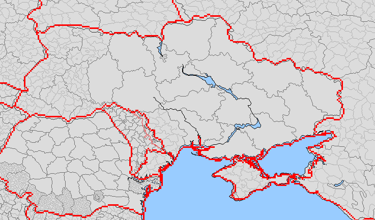

Самая большая проблема карты Украины - региональные границы и реки. Они выглядят
https://www.imbf.org/tools/images/podrobnaja-politicheskaja-i-administrativnaja-karta-ukrainy-hq.jpg
I know that it isn't Robinson
https://www.imbf.org/tools/images/podrobnaja-politicheskaja-i-administrativnaja-karta-ukrainy-hq.jpg
I know that it isn't Robinson
Last edited:
Share: