Extensively. One of my favorite things was the Holy European Union.BTW, has the fate of Europe (what it looks like now) been discussed?
You are using an out of date browser. It may not display this or other websites correctly.
You should upgrade or use an alternative browser.
You should upgrade or use an alternative browser.
Medieval America Tk II: Discussion Thread
- Thread starter jmberry
- Start date
The old thread should not be considered canon with regards to this one. Some of the ideas there can be brought back for discussion (as with my Masons concept), but until then they shouldn't be viewed with any real weight.
In any event, Europe is not open for discussion, the thread should remain focused on North America, after which it will probably move to South America, Australia/Oceania, Africa, and then Eurasia.
In any event, Europe is not open for discussion, the thread should remain focused on North America, after which it will probably move to South America, Australia/Oceania, Africa, and then Eurasia.
Agreed. Europe, Asia and Africa been done (700 years ago)The old thread should not be considered canon with regards to this one. Some of the ideas there can be brought back for discussion (as with my Masons concept), but until then they shouldn't be viewed with any real weight.
In any event, Europe is not open for discussion, the thread should remain focused on North America, after which it will probably move to South America, Australia/Oceania, Africa, and then Eurasia.
Or abandoned altogether due to phonetic similarity with a certain term of abuse
I must have missed it on the blog. Anyway, I'd imagine that with medieval-level technology, crossing ocean expenses would be very dangerous, and hardly worth it (I mean, what's in Europe America does not have? White himself says that trade in medieval world connects places of different biomes producing different goods. Europe is basically the same as Eastern US, so except fine arts and perhaps some high-luxury goods (French wine, Swiss clockworks) there isn't much worth the dangers inherent to the crossing.
Ivory.
Or rather, (relatively) easy access to sources of ivory. Really, Europe's real role in all of this would be to act as a go-between for the other continents.
Ivory.
Or rather, (relatively) easy access to sources of ivory. Really, Europe's real role in all of this would be to act as a go-between for the other continents.
What ivory? Elephants are almost gone, and I don't think they'd survive the Downfall of modern civilization (even if it was not cataclysmic, White mentions that 4/5ths of the US population succumbed to famine. It would be similar in Africa and even worse in India, so I imagine the hundreds of millions of starving people wouldn't give a damn about whether the elephants and hippos and rhinos are endangered species or not. They'd have been hunted for meat to extinction while modern firearms were still available, thus concluding the last chapter of the post-Pleistocene big mammal genocide at the hands of humans). I doubt you want any sci-fi elements in this, so no re-introduced mammoths in Siberia either.
I recall you writing that Elephants had escaped to the Swamps and the Plains.Ivory.
Or rather, (relatively) easy access to sources of ivory. Really, Europe's real role in all of this would be to act as a go-between for the other continents.
Enough discussion on trade. It is unimportant to the project right now - which is not a realistic post-apocalyptic scenario, but a thought process on feudal and other quasi-medieval societies in the Americas. When Europe is fleshed out, then we can go back and see what they can provide. Until then, trade exists between North America and Europe, period.
And no animals went extinct between the Collapse and the "present" - that is non-negotiable.
And no animals went extinct between the Collapse and the "present" - that is non-negotiable.
Since we're taking this in regional chunks, where do we move onto next? The pacific Northwest? From there I would assume Alaska, then Deseret, then a bit more (as if White hasn't already done enough  ) on the Cowboys, then Coastal Texas, then... well that's a bridge we'll cross when we come to it.
) on the Cowboys, then Coastal Texas, then... well that's a bridge we'll cross when we come to it.Since we're taking this in regional chunks, where do we move onto next? The pacific Northwest? From there I would assume Alaska, then Deseret, then a bit more (as if White hasn't already done enough
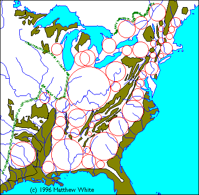
We've already done the Pacific Northwest, the Southwest, the Plains, California, Deseret, and Iowa, as well as Quebec and Alaska. The current focus is on the East now
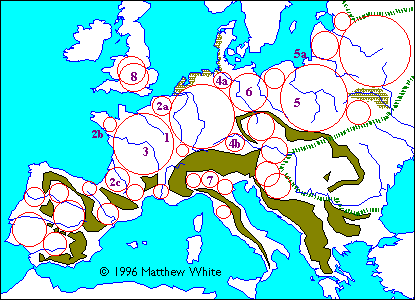
Before that, I'd like to ask about these from the collection of White's maps. Have they been discussed? Can somebody tell what method was employed here and what the conclusions were? What the numbers/letters on the one depicting Europe denote? I think I understand the principles (mark areas unsuitable to medieval agriculture—mountain ranges, swamps, steppes, taiga—and then try to draw circles as big as possible without touching these areas or one another), but I'd VERY much want to know if some details concerning how this method works have been discussed.
Then shouldn't we move the focus to the Caribbean/ Louisiana?We've already done the Pacific Northwest, the Southwest, the Plains, California, Deseret, and Iowa, as well as Quebec and Alaska. The current focus is on the East now
Before that, I'd like to ask about these from the collection of White's maps. Have they been discussed? Can somebody tell what method was employed here and what the conclusions were? What the numbers/letters on the one depicting Europe denote? I think I understand the principles (mark areas unsuitable to medieval agriculture—mountain ranges, swamps, steppes, taiga—and then try to draw circles as big as possible without touching these areas or one another), but I'd VERY much want to know if some details concerning how this method works have been discussed.
Short of White coming out of whatever aether he disappeared into and explaining it, your explanation is about the best one seen (although I did notice an implication that Michigan is NA's England).
Then shouldn't we move the focus to the Caribbean/ Louisiana?
The Caribbean will come later (although I wrote a small post on Latin America earlier in this thread). Dixie, the Feudal Core, and the Northeast are all being taken in at once due to their close proximity and connections to each other (in contrast to the west, which were worlds unto themselves).
Short of White coming out of whatever aether he disappeared into and explaining it, your explanation is about the best one seen (although I did notice an implication that Michigan is NA's England).
Well, for instance I don't understand why England has two overlapping circles - both are equally possible and/or so close it doesn't matter? And what exactly qualifies as 'unsuitable' terrain - especially Italy looks... strange, while Hungary pretty quickly became feudal once the Magyars settled down (the parallel between Hungary and the Territory of Iowa is clear.) Too bad White has disappeared because the method he used could potentially be useful in world-building of the other areas of medieval Earth, when/if you guys ever get to it.
The circles on the US map pretty well correspond with the map of its feudal states, BTW.
Once more on the administrative/noble ranks, just briefly.
Land title -> ruler -> ~real-world medieval European equivalent
N/A -> deputy -> ~(landed) knight. (Most common among the warrior-nobility of feudal America. Landed deputies usually rule from a small rural fortress and protect the surrounding lands. Landless deputies usually serve in household retinues of higher nobles.)
township -> sheriff -> ~baron. (Initially powerful nobles ruling county-sized regions, their power has shrunk as the number of people claiming the title of sheriff grew. Right now they usually oversee a township-sized areas. Subordinate deputies swear fealty to them and fight for them when necessary. Inheritance differs from region to region, the most common being primogeniture [eldest son inherits the title and the lands] and a form of tanistry [the sheriff's family and deputies appoint an heir from among his immediate male relatives]. Sheriffs usually maintain a small standing retinue [bodyguards] to deal with bandits, foreign raids or troublesome deputies without having to rely on their subordinate deputies for manpower.)
district/borough/shire -> warden/chief/vice, etc. -> ~count. (One of the newer titles introduced when governors and other higher rulers got tired of micromanagement. Instead of dealing with dozens of smaller vassals [sheriff-rank], they chose to elevate one to a higher rank, usually called a "warden" [or "chief" or "vice", derived from "sheriff-warden", "chief sheriff" and "vice-count"] to rule a collection of townships called "districts" and "boroughs" and "shires" (especially in the Northeast) in their stead. Unlike the medieval European counties, districts/boroughs/shires are seldom independent or indeed even stable entities. Governors often re-shuffle them as it suits their immediate interests, and the titles themselves are usually elective. The process of solidification and traditionalisation of the district/borough/shire system and its associated titles has advanced the most in those states where governors have traditionally been weak and unable to dominate their vassals.)
county -> executor/director/commissioner/count -> ~duke. (As the administrative system of the old US fell apart, the county mostly ceased to exist as an administrative entity. Later, however, it re-emerged as the name for the largest sub-state entity when various warlords who amassed enough power in a given region sought to give their fiefdoms fancier and legitimate names. Thus, a county in medieval America is roughly equivalent in size and internal subdivision to a medieval European duchy. The names of their titular rulers differ wildly. The simple "count" fell out of favour early on, though it still hangs on in some places. When a county is a part of a state or a commonwealth, its ruler are often called an "executor" as he executes the will of the Governor as his immediate vassal. This is believed to have derived either from "County Executive" in the old US, or "Executive Officer" in those counties which initially were a part of states carved out by ex-military warlords. Whatever the title, the rulers of counties are the most powerful outside the domain of governors and presidents. Often they wield enough power to make a Governor think twice about offending them. Some counties have achieved de-facto independence and are thus equivalent to States.
state/commonwealth -> governor/president -> ~king. (The standard name for an independent political entity in feudal America. Initially still considered a constituent part of the Union, but as the old US political system collapsed they achieved first de facto and then de iure independence. The most powerful states occupying territories formerly belonging to more than one state usually call themselves Commonwealths, stressing their power, 'republican' origins and the justness of their rulers who rule with the 'consent' of the people. Even though their rulers sometimes style themselves as "presidents", there is little practical difference between them and the States ruled by Governors. In Canada, states may be referred to as "Dominions".)
the Union -> President of the United States -> ~emperor. (Currently defunct. The "other US", i.e. the merchant republic ruling the East Coast littorals claims legal continuity with the old US and therefore its presidents sometimes consider themselves above the other rulers in feudal America, but very few actually recognize such a claim. Instead, "the Union" remains a hypothetical pinnacle of political organization that many a Governor have aspired to. However, due to the feudal nature of present-day America, uniting the fractioned States and Commonwealths into anything approaching the old US in size and cohesion remains an impossible dream.)
Speakign of which; was it this thread or the old thread we discussed a series of muslim kingdoms in the Rockies?Yeah, that all sounds about right. I especially like "Warden" for count as prisons would actually make good impromptu castles.
And wouldn't the Quebecois be called a Union by outsiders?
Speakign of which; was it this thread or the old thread we discussed a series of muslim kingdoms in the Rockies?
Um, that was my idea here on this thread because of the preponderance of Muslims in the federal prisons due to the War on Terror.
Um, that was my idea here on this thread because of the preponderance of Muslims in the federal prisons due to the War on Terror.
Isn't that too topical considering how vague we are being about the fall? Also I don't think that there would be enough population for a series. I one Muslim kingdom hidden away I could understand as it could be formed by Muslims fleeing persecution but if it was well know it would get crusaded into oblivion.
I think it's a pretty good post.The Five States of Islamistan
Well, here are the five areas in which I think my idea of a "Dar as-Islam" among the Colorado Rockies based off of escapees from the Supermax outside of Florence. The most strict of the five "states" is along the headwaters of the Arkansas river, and is based out the fort built of the ruins of the Supermax itself (the bluish-green in Lake, Chaffee, Custer, and Freemont counties). The furthest south, and a cultural blend with the Southwestern Hydraulic culture is in the San Luis Valley (the light green headwaters of the Rio Grande to the line between San Antonio Mountain and Ute Mountain, the with portions of San Juan, Hinsdale, Mineral, Saguache, Rio Grande, Conejos, Alamosa, and Costilla in Colorado and Rio Arriba and Taos County in New Mexico). Above the Arkansas State is South Park (the brown-green in Park County), which maintains the most of its pre-Fall character, though like all of the Muslim Rockies, is officially Muslim, though a majority are Dhimmi (non-muslims in a muslim state). Middle Park (the teal in Summit and Grand counties) is closest in culture to Deseret, though as they are along the old I-79 corridor, act as a secondary trade route (as opposed to the primary through South pass) between the Cowboys and Deseret. North Park (the blue of Jackson county and a bit of Carbon County Wyoming) is closest in culture to the Cowboys, and is farthest from the cultural center of the Arkansas state, so it's only the fact that it's a primarily agricultural area, with about twice the population as it had before the fall (at 3000 versus 1500), though the wild game (deer, elk, and beefalo) is quite thick, giving the area it's even older name of "Bull Pen" some weight.
Unlike many of the areas in the new America, the Five States of the "Dar as-Islam" in the Rockies have people with ancestors from all over North America (as well as even further afield, such as Afghanistan), who had immigrated to the region when they heard about the "Islamic Sanctuary" there. While Muslims are a majority in Arkansaas, they're only a plurality or the ruling minority in Quiddis Luis, Hadīqa al-Janubíyya, Hadīqa al-Wásat, and Hadīqa al-Shamalíyya. One of the important things to remember about Islamistan is that all "people of the book", including the descendent religions (so those descended from Judaism and Christianity, though not the Scientology of California), are afforded certain permissions under the law, though they are taxed a bit more than muslims would be. Due to the distances involved, the months of the Islamistan lunar calendar are based on the first sighting of the hilal from the minaret of the main mosque in Florence (though due to the Rockies, and the weather in general, it's been "standardized" to the Tabular Islamic calendar, making things predictable when storms threaten to isolate the Five States of Islamistan).
Attached Images
Share: