You are using an out of date browser. It may not display this or other websites correctly.
You should upgrade or use an alternative browser.
You should upgrade or use an alternative browser.
Canada Wank (YACW)
- Thread starter Dathi THorfinnsson
- Start date
- Status
- Not open for further replies.
Miscellaneous
[FONT=Arial, sans-serif]Miscellaneous [/FONT]
[FONT=Arial, sans-serif]Iron working/Iron infrastructure[/FONT]
[FONT=Arial, sans-serif]After the Iron Range is discovered in Wisconsin (OTL Minnesota) in 1827, efforts are made to mine and use this ore, but not much can be done until infrastructure improves. A lock and canal around the rapids at Sault Ste Marie is started in 1829 and finished in 1833. This is financed in good part by the Northwest Company, which a) wants better access to Lake Superior for its traffic, and b) is also financing the iron mine (expanding their business in new directions). Several hundred pounds a year of ore are dug out each year in the intervening time and hauled across the existing portage at high expense (more as proof of concept than as a profitable venture). These early loads of iron are used to start iron production with a small furnace at Chicago, to get practice. Meanwhile, a larger mine is started back in the Iron Range, a large foundry is under construction at Chicago, and coal just south and east of Chicago is being examined for possible use as fuel, both in said foundry and also for all the steamboats and other steam engines that are multiplying like rabbits.[/FONT]
[FONT=Arial, sans-serif]Norton guns[/FONT]
[FONT=Arial, sans-serif]In 1832 a Captain John Norton invented a bullet that would make rifles far more practical (similar to OTL's Minie Ball). The British Ordnance department wasn't initially interested[1], but the strained tensions with the US makes them reconsider, and Norton spends the next 5 years experimenting and improving his system. Then, the British armouries tool up to replace the unrifled muskets with this new Norton gun, a rifled musket. Within 5 years, they hope to be able to replace every unrifled musket in the British army with this rifled version, massively improving accuracy and range, while keeping the same rate of fire. This will also free up thousands and thousands of old, obsolete muskets...[/FONT]
Paixhans guns
General Henri-Joseph Paixhans invents the cannon bearing his name in 1823, which is optimized for firing explosive shells. Previously, explosive shells were only fired from special mortars, which in the case of ships, required a wholly different class of ships – the bomb ketches. With the Paixhans gun, for the first time, one could fire [FONT=Arial, sans-serif]such a shell on a flat trajectory (instead of lobbing a shell in a high arc like the mortars did), and fire them from a regular war ship. This type of gun and shell pretty much rendered the wooden warship dead, which was a problem, as there wasn't any replacement on the drawing boards. Britain, with her huge investment in wooden ships wasn't terribly interested at first, but when the US started negotiating with the French for a) cannon and b) license to make their own, the British knew they had to respond. [2][/FONT]
[FONT=Arial, sans-serif]Even if duels between Paixhans gunned warships was going to be rather like a knife fight or a duel at 10 paces (i.e. both combatants badly injured or dieing at the end), the British had far more ships, and could afford to lose a few far better than the Americans could (for instance). Thus the British start a massive effort to cast hundreds of their own versions of these new cannons, get them into their ships (at least one or two in every RN ship is the hope), and revise their strategy to emphasis aiming guns. (As the first ship that scores a hit from the furthest away may win the battle.)[/FONT]
[FONT=Arial, sans-serif]Tin Cans[/FONT]
[FONT=Arial, sans-serif]Tin cans were invented in 1810 and the first factory built in 1813. The military quickly realized the importance of the technology for e.g. storing food on ships. Thin sheets of iron, coated in tin to prevent corrosion, are soldered together by hand to provide a hermetic seal for the food stored inside, which can thus keep for a long time. The average worker could produce 6 cans an hour, which was reasonable, but kept the cost out of reach of ordinary use for some time.[/FONT]
[FONT=Arial, sans-serif]Unfortunately, the early solders contained lead, which meant that iOTL, the 3rd Franklin expedition's Arctic disaster was partly caused by lead poisoning from their stores. [/FONT]
[FONT=Arial, sans-serif]ITTL, several canning factories are set up to provide reserve provisions for the military especially any border forts that can be reached by water or short road. (The one DISadvantage of canned goods is that they are so heavy.) Once rail becomes available to increase supply to the forts, the canning industry expands heavily. They hope to have a full years supply of canned food (plus staples like grain), just in case any US invasion might cut the forts off from supply.[/FONT]
–
[FONT=Arial, sans-serif]1 Norton and his gun are OTL. The Ordnance department ignored it, secure in British superiority, and it was left to the French to develop the Minié Ball and Rifle, leaving the British to play catch up.[/FONT]
[FONT=Arial, sans-serif]2 Again, precisely why the British didn't do much with these cannon OTL. The US did buy/steal/license, I'm not sure which, the technology, and installed 4 on the Constitution (old Ironsides) by 1842. Here, the British HAVE to react.[/FONT]
Guys:
Could I have some advice on the American flag?
How long do you guys think it will take before they are going to remove stars - presumably they have to at some point. Are they going to paint them black or something (replace them by x's ???).
Or do they sweep the whole thing under the rug and return to the Betsy Ross flag for a couple of decades, or something?
Guys:
Could I have some advice on the American flag?
How long do you guys think it will take before they are going to remove stars - presumably they have to at some point. Are they going to paint them black or something (replace them by x's ???).
Or do they sweep the whole thing under the rug and return to the Betsy Ross flag for a couple of decades, or something?
I'd think they'd leave the flag as is until anger about the whole thing subsides, at which point they'll remove the surplus stars and stripes and collectively sigh despondently.
Guys:
Could I have some advice on the American flag?
How long do you guys think it will take before they are going to remove stars - presumably they have to at some point. Are they going to paint them black or something (replace them by x's ???).
Or do they sweep the whole thing under the rug and return to the Betsy Ross flag for a couple of decades, or something?
I would say swept under the rug, retaining the stars and stripes representing the New England states as a form of staking a claim on the land (since presumably nobody inside the US recognizes an independent New England and would prefer it that way).
Rail development to 1840
Rail
[FONT=Arial, sans-serif]Introduction[/FONT]
[FONT=Arial, sans-serif]Before 1830 there were essentially no railroads anywhere (aside from local tramways to move specific products – usually coal). [/FONT]
[FONT=Arial, sans-serif]The initial railroads were built as adjuncts to the water ways. There was no way, in the early days of rail, that rail could replace water transport. By the time that rail becomes practical, the main canals have already gone in, allowing (small) sea-going vessels access to Chicago, and from there, barges/riverboats could transport material to St. Louis. [/FONT]
[FONT=Arial, sans-serif]In September 1830 the Manchester and Liverpool Railway opened in England, for a distance of 35 miles. The first section of the Baltimore and Ohio railway also opened 1830 (in May) . In 1833 the Charleston and Hamburg railroad reached Hamburg (on the Georgia border, across the river from Augusta Georgia) inland, a distance of 136 miles, and the world's longest railway at the time. By the end of 1835, the B&O (Baltimore and Ohio) connected Baltimore with Washington DC; the Pennsylvania Main line of Public Works (rail and canal, including the Allegheny portage road) connected Philadelphia to Pittsburgh. Philadelphia was also connected to New York City. Similarly, rail headed out of Boston west to Worcester and south to Providence RI. All told, some 1062 miles, or so, in the US. (OTL)[/FONT]
[FONT=Arial, sans-serif](http://oldrailhistory.com/index.php?option=com_frontpage&Itemid=1 is a wonderful source).[/FONT]
[FONT=Arial, sans-serif]British/Canadian reaction[/FONT]
[FONT=Arial, sans-serif]The British and Canadian governments quickly realised that they were falling behind, and started their, more mo[/FONT]dest systems. In 1833, ground is broken on the Champlain & St. Lawrence The C&SL was financed by private investor led by John Molson, and by the federal government. This first stage was intended as a portage road to connect the St. Lawrence River valley with Lake Champlain, cutting time from the trip between Montreal and points south, especially Plattsburgh. The line would run from St. Jean-sur-Richelieu on the Richelieu River to the nearest point on the St. Lawrence at La Prairie, [FONT=Arial, sans-serif]14 miles upriver from Montreal. [/FONT]Throughout 1833 rail is built, as well as stations and wharves at La Prairie and [FONT=Arial, sans-serif]St. Jean[/FONT]. Orders were also placed for a locomotive from Stephenson (the builder of the Rocket), which arrived in June of 1834. Initial operation started in July of that year. As the one engine could only be in one place at one time, and haul so much, other trains are pulled by horses until such time as more locomotives are bought or built. Because Stephenson's works are rather backed up by demand from Britain, Molson has his steamboat people (from Forges St. Maurice in Trois Rivières) look at the existing engine, and make their own. This stage of the railway is 16-miles long, built as a 5ft 6in (1,676mm) (iTTL, Canadian gauge, OTL Provincial gauge) railway, which will be the standard for all BNA rail. The railway then extended south toRouses Point[FONT=Arial, sans-serif] in the middle of 1835 and then later to Plattsburgh in 1836, although these latter lines had more government funding. Molson also built a few miles of other lines in the immediate Montréal area with his own funding.[/FONT]
[FONT=Arial, sans-serif]In 1834 rail construction is also started on a line connecting the Thames river near OTL Woodstock Ontario to the head of Lake Ontario (OTL Hamilton). This connects the Thames to the Grand River (OTL Paris) to Lake Ontario, a distance of some 50 miles. Only 20 miles were completed that first year, but the project was completed before the end of 1835. This railroad had commercial value and was largely commercially funded. Another chunk of rail that was put in early was the connexion between the Maumee River at Fort Wayne and the headwaters of the Wabash, initially a dozen miles, or so. Completed that year, and then extended to OTL's Huntington and beyond. Again, there was enough business flowing on the route to pay for itself.[/FONT]
[FONT=Arial, sans-serif]So, at the end of 1835, the race is approximately 111 miles of track for the Canadians vs 1000+ for the US and some 72 in New England.[/FONT]
[FONT=Arial, sans-serif]1836. On the US side, a railroad running from Buffalo to Niagara Falls is built (to allow American goods, especially military goods to travel from Lake Ontario to Lake Erie. [/FONT]
[FONT=Arial, sans-serif]In 1836, rail heads west from Detroit towards (OTL's) Lansing MI arriving there in 1840. There it meets the Grand River, from which goods are transferred to boats and shipped west to near Grand Rapids. At (OTL Forest Hills) 10 miles of rail are constructed to Grand Rapids itself, cutting off a loop of the river, and the rapids themselves (started and finished in 1836). From there, later, rail heads SE to (OTL Holland MI) on Lake Michigan, and then continues on to Chicago, but it is not nearly as vital an effort. Similarly, rail is built between Grand Rapids and Lansing, with somewhat less urgency.[/FONT]
[FONT=Arial, sans-serif]1836 is also the first year that any significant amount of T-rail is produced/laid. The earlier rail was strap rail – an iron bar or strap laid on the top of a wooden rail. This obviously isn't nearly as useful as a solid iron rail, but a) costs less, and b) makes better use of the relatively limited iron supply.[/FONT]
[FONT=Arial, sans-serif]In 1837 there is a short railroad built from the coalmines in Illinois to the Illinois River, and another from the mines at Iron Range to Lake Superior. These two lines massively increase the amount of iron that can be smelted at Chicago, which is a good thing with all the development (especially RR) going on.[/FONT]
[FONT=Arial, sans-serif]One of the highest military priorities for the new rail lines is to connect and supply the forts along the US border with the Confederacy, which are mostly NOT on convenient waterways. Thus, maximum effort and top priority is given to these connexions. The building happens in 4 major prongs. 1) a line south from Fort Wayne towards Indianapolis (a settlement and transport hub approximately in the same place and with the same name (even more appropriately) as OTL). As this line has probably the best logistics connexion (up the Maumee from Lake Erie), it moves fastest. 2) a line east and somewhat north from Fort Liverpool (just north of OTL Terre Haute, IN) to meet at Indianapolis. 2a) a line west Rail also goes west and then south paralleling the Wabash and then later 2b) continuing north and west to the Sangamon river (OTL's Decatur), from which boats can be used to transport goods to St. Louis, thus opening up another chunk of land to commerce/*settlement. 2c) And rail goes north to connect to Chicago, but this is a lower priority. 3) Further down the Wabash (about 50 miles from Liverpool), the British build a fort and rail head at St. Francis (near the site of OTL's St. Francisville), on the west bank of the Wabash. From there, rail heads west to service the forts to the west in OTL's Illinois and meet line 4. Rail also heads north to meet line 2a. 4) rail heads east from St. Louis to meet line 3. This line is supplied from St. Louis, which vies with Ft. Wayne for decent supply lines. Rail and engines can be shipped from England to New Orleans, then up the Mississippi to St. Louis, and that's as convenient as down the lakes, almost.[/FONT]
[FONT=Arial, sans-serif]As these various trunk lines are built (somewhat back from the border), branch lines to individual forts are built, too.[/FONT]
[FONT=Arial, sans-serif]This whole network is completed in 1841, and massive supply and upgrade efforts flow to the individual forts as the are connected by rail.[/FONT]
[FONT=Arial, sans-serif]Vermont/New England[/FONT]
[FONT=Arial, sans-serif]With rail already coming south from Montreal, the Vermonters build rail to connect. In 1836 they only build out to Essex Junction, their main rail hub just east of Burlington, but in the following years they build north to Swanton where they meet a spur from the Montreal-Plattsburgh line in 1838; and they build southeast, towards Montpelier, White Junction and on past that towards Concord NH. [/FONT]
[FONT=Arial, sans-serif]Meanwhile the Massachusetts and New Hampshire lines head northwest from the northern Boston suburbs, Andover MA to Manchester NH to Concord NH and on to meet the Vermonter line.[/FONT]
[FONT=Arial, sans-serif]White Junction becomes a very important stop on this line, as the Vermont rail line used the Canadian gauge (5'6”), while the rest of New England was using Standard gauge 4'8.5”. Thus all goods and passengers need to stop and change trains at White Junction where the gauges meet.[/FONT]
[FONT=Arial, sans-serif]This rail is complete by 1840, at the end of the year. This now gives Montreal rail access to a year-round port, and it gives New England merchants much better access to the Canadian interior. [/FONT]
[FONT=Arial, sans-serif]In truth, Montreal would rather have connected to Portland Maine (there was some discussion of it), but the route would have provided no intermediate connexions to provide extra traffic, and basically had no chance of raising the extra funding. Portland and Montréal merchants continue to agitate for a line connecting their cities and extending on into New Brunswick and Nova Scotia, but such a project would be very expensive, have little commercial use, and there are other priorities right now.[/FONT]
[FONT=Arial, sans-serif]Manufacturing[/FONT]
[FONT=Arial, sans-serif]The incredible increase of railway expansion here, compared to OTL means that every forge and foundry available is kept thoroughly busy. Moreover, Britain is having to do rather more cannon founding than OTL, so some of the foundries there are no longer available to produce for the railway industry. Thus more of the load falls on local Canadian industry, which although cruder and more expensive is a) available and b) local.[/FONT]
[FONT=Arial, sans-serif]In particular, Molson's steam-engine building expands to Marmora (which can handle a higher volume of iron than les Forges St. Maurice, and which has the most modern production plant). And all the foundries expand as much as they can. Forges St. Maurice has a limited local source of iron, and can't expand much, Marmora with an intermediate level of ore and good plant specializes in the higher end production, but Sydney NS and Chicago with huge water-borne access to iron and with local coal, are limited only by the size of the foundries and number of men to man them.[/FONT]
[FONT=Arial, sans-serif]Rump US[/FONT]
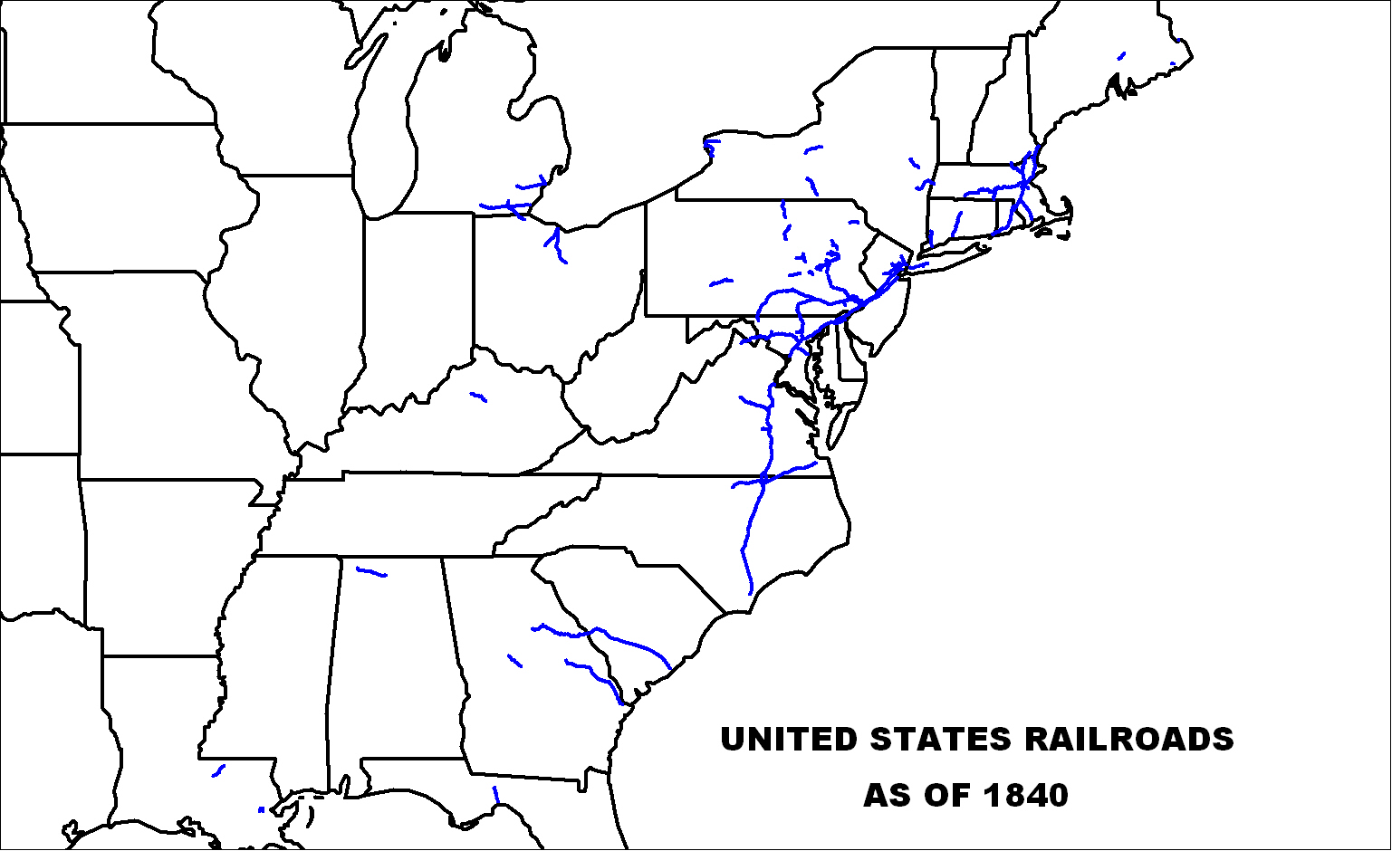
[FONT=Arial, sans-serif]As for US rail, look at the map at
 [/FONT]
[FONT=Arial, sans-serif] http://oldrailhistory.com/images/stories/rail1840.jpg[/FONT]
[FONT=Arial, sans-serif]Here's an iTTL rough version of the same.
Turquoise is ATL rail in the US; Red, ATL rail in Canada; Green ATL rail in New England. Note that some of OTL's rail in the US has disappeared in the second map.
[/FONT]

Rail
[FONT=Arial, sans-serif]Introduction[/FONT]
[FONT=Arial, sans-serif]Before 1830 there were essentially no railroads anywhere (aside from local tramways to move specific products – usually coal). [/FONT]
[FONT=Arial, sans-serif]The initial railroads were built as adjuncts to the water ways. There was no way, in the early days of rail, that rail could replace water transport. By the time that rail becomes practical, the main canals have already gone in, allowing (small) sea-going vessels access to Chicago, and from there, barges/riverboats could transport material to St. Louis. [/FONT]
[FONT=Arial, sans-serif]In September 1830 the Manchester and Liverpool Railway opened in England, for a distance of 35 miles. The first section of the Baltimore and Ohio railway also opened 1830 (in May) . In 1833 the Charleston and Hamburg railroad reached Hamburg (on the Georgia border, across the river from Augusta Georgia) inland, a distance of 136 miles, and the world's longest railway at the time. By the end of 1835, the B&O (Baltimore and Ohio) connected Baltimore with Washington DC; the Pennsylvania Main line of Public Works (rail and canal, including the Allegheny portage road) connected Philadelphia to Pittsburgh. Philadelphia was also connected to New York City. Similarly, rail headed out of Boston west to Worcester and south to Providence RI. All told, some 1062 miles, or so, in the US. (OTL)[/FONT]
[FONT=Arial, sans-serif](http://oldrailhistory.com/index.php?option=com_frontpage&Itemid=1 is a wonderful source).[/FONT]
[FONT=Arial, sans-serif]British/Canadian reaction[/FONT]
[FONT=Arial, sans-serif]The British and Canadian governments quickly realised that they were falling behind, and started their, more mo[/FONT]dest systems. In 1833, ground is broken on the Champlain & St. Lawrence The C&SL was financed by private investor led by John Molson, and by the federal government. This first stage was intended as a portage road to connect the St. Lawrence River valley with Lake Champlain, cutting time from the trip between Montreal and points south, especially Plattsburgh. The line would run from St. Jean-sur-Richelieu on the Richelieu River to the nearest point on the St. Lawrence at La Prairie, [FONT=Arial, sans-serif]14 miles upriver from Montreal. [/FONT]Throughout 1833 rail is built, as well as stations and wharves at La Prairie and [FONT=Arial, sans-serif]St. Jean[/FONT]. Orders were also placed for a locomotive from Stephenson (the builder of the Rocket), which arrived in June of 1834. Initial operation started in July of that year. As the one engine could only be in one place at one time, and haul so much, other trains are pulled by horses until such time as more locomotives are bought or built. Because Stephenson's works are rather backed up by demand from Britain, Molson has his steamboat people (from Forges St. Maurice in Trois Rivières) look at the existing engine, and make their own. This stage of the railway is 16-miles long, built as a 5ft 6in (1,676mm) (iTTL, Canadian gauge, OTL Provincial gauge) railway, which will be the standard for all BNA rail. The railway then extended south toRouses Point[FONT=Arial, sans-serif] in the middle of 1835 and then later to Plattsburgh in 1836, although these latter lines had more government funding. Molson also built a few miles of other lines in the immediate Montréal area with his own funding.[/FONT]
[FONT=Arial, sans-serif]In 1834 rail construction is also started on a line connecting the Thames river near OTL Woodstock Ontario to the head of Lake Ontario (OTL Hamilton). This connects the Thames to the Grand River (OTL Paris) to Lake Ontario, a distance of some 50 miles. Only 20 miles were completed that first year, but the project was completed before the end of 1835. This railroad had commercial value and was largely commercially funded. Another chunk of rail that was put in early was the connexion between the Maumee River at Fort Wayne and the headwaters of the Wabash, initially a dozen miles, or so. Completed that year, and then extended to OTL's Huntington and beyond. Again, there was enough business flowing on the route to pay for itself.[/FONT]
[FONT=Arial, sans-serif]So, at the end of 1835, the race is approximately 111 miles of track for the Canadians vs 1000+ for the US and some 72 in New England.[/FONT]
[FONT=Arial, sans-serif]1836. On the US side, a railroad running from Buffalo to Niagara Falls is built (to allow American goods, especially military goods to travel from Lake Ontario to Lake Erie. [/FONT]
[FONT=Arial, sans-serif]In 1836, rail heads west from Detroit towards (OTL's) Lansing MI arriving there in 1840. There it meets the Grand River, from which goods are transferred to boats and shipped west to near Grand Rapids. At (OTL Forest Hills) 10 miles of rail are constructed to Grand Rapids itself, cutting off a loop of the river, and the rapids themselves (started and finished in 1836). From there, later, rail heads SE to (OTL Holland MI) on Lake Michigan, and then continues on to Chicago, but it is not nearly as vital an effort. Similarly, rail is built between Grand Rapids and Lansing, with somewhat less urgency.[/FONT]
[FONT=Arial, sans-serif]1836 is also the first year that any significant amount of T-rail is produced/laid. The earlier rail was strap rail – an iron bar or strap laid on the top of a wooden rail. This obviously isn't nearly as useful as a solid iron rail, but a) costs less, and b) makes better use of the relatively limited iron supply.[/FONT]
[FONT=Arial, sans-serif]In 1837 there is a short railroad built from the coalmines in Illinois to the Illinois River, and another from the mines at Iron Range to Lake Superior. These two lines massively increase the amount of iron that can be smelted at Chicago, which is a good thing with all the development (especially RR) going on.[/FONT]
[FONT=Arial, sans-serif]One of the highest military priorities for the new rail lines is to connect and supply the forts along the US border with the Confederacy, which are mostly NOT on convenient waterways. Thus, maximum effort and top priority is given to these connexions. The building happens in 4 major prongs. 1) a line south from Fort Wayne towards Indianapolis (a settlement and transport hub approximately in the same place and with the same name (even more appropriately) as OTL). As this line has probably the best logistics connexion (up the Maumee from Lake Erie), it moves fastest. 2) a line east and somewhat north from Fort Liverpool (just north of OTL Terre Haute, IN) to meet at Indianapolis. 2a) a line west Rail also goes west and then south paralleling the Wabash and then later 2b) continuing north and west to the Sangamon river (OTL's Decatur), from which boats can be used to transport goods to St. Louis, thus opening up another chunk of land to commerce/*settlement. 2c) And rail goes north to connect to Chicago, but this is a lower priority. 3) Further down the Wabash (about 50 miles from Liverpool), the British build a fort and rail head at St. Francis (near the site of OTL's St. Francisville), on the west bank of the Wabash. From there, rail heads west to service the forts to the west in OTL's Illinois and meet line 4. Rail also heads north to meet line 2a. 4) rail heads east from St. Louis to meet line 3. This line is supplied from St. Louis, which vies with Ft. Wayne for decent supply lines. Rail and engines can be shipped from England to New Orleans, then up the Mississippi to St. Louis, and that's as convenient as down the lakes, almost.[/FONT]
[FONT=Arial, sans-serif]As these various trunk lines are built (somewhat back from the border), branch lines to individual forts are built, too.[/FONT]
[FONT=Arial, sans-serif]This whole network is completed in 1841, and massive supply and upgrade efforts flow to the individual forts as the are connected by rail.[/FONT]
[FONT=Arial, sans-serif]Vermont/New England[/FONT]
[FONT=Arial, sans-serif]With rail already coming south from Montreal, the Vermonters build rail to connect. In 1836 they only build out to Essex Junction, their main rail hub just east of Burlington, but in the following years they build north to Swanton where they meet a spur from the Montreal-Plattsburgh line in 1838; and they build southeast, towards Montpelier, White Junction and on past that towards Concord NH. [/FONT]
[FONT=Arial, sans-serif]Meanwhile the Massachusetts and New Hampshire lines head northwest from the northern Boston suburbs, Andover MA to Manchester NH to Concord NH and on to meet the Vermonter line.[/FONT]
[FONT=Arial, sans-serif]White Junction becomes a very important stop on this line, as the Vermont rail line used the Canadian gauge (5'6”), while the rest of New England was using Standard gauge 4'8.5”. Thus all goods and passengers need to stop and change trains at White Junction where the gauges meet.[/FONT]
[FONT=Arial, sans-serif]This rail is complete by 1840, at the end of the year. This now gives Montreal rail access to a year-round port, and it gives New England merchants much better access to the Canadian interior. [/FONT]
[FONT=Arial, sans-serif]In truth, Montreal would rather have connected to Portland Maine (there was some discussion of it), but the route would have provided no intermediate connexions to provide extra traffic, and basically had no chance of raising the extra funding. Portland and Montréal merchants continue to agitate for a line connecting their cities and extending on into New Brunswick and Nova Scotia, but such a project would be very expensive, have little commercial use, and there are other priorities right now.[/FONT]
[FONT=Arial, sans-serif]Manufacturing[/FONT]
[FONT=Arial, sans-serif]The incredible increase of railway expansion here, compared to OTL means that every forge and foundry available is kept thoroughly busy. Moreover, Britain is having to do rather more cannon founding than OTL, so some of the foundries there are no longer available to produce for the railway industry. Thus more of the load falls on local Canadian industry, which although cruder and more expensive is a) available and b) local.[/FONT]
[FONT=Arial, sans-serif]In particular, Molson's steam-engine building expands to Marmora (which can handle a higher volume of iron than les Forges St. Maurice, and which has the most modern production plant). And all the foundries expand as much as they can. Forges St. Maurice has a limited local source of iron, and can't expand much, Marmora with an intermediate level of ore and good plant specializes in the higher end production, but Sydney NS and Chicago with huge water-borne access to iron and with local coal, are limited only by the size of the foundries and number of men to man them.[/FONT]
[FONT=Arial, sans-serif]Rump US[/FONT]
[FONT=Arial, sans-serif]As for US rail, look at the map at
[FONT=Arial, sans-serif] http://oldrailhistory.com/images/stories/rail1840.jpg[/FONT]
[FONT=Arial, sans-serif]Here's an iTTL rough version of the same.
Turquoise is ATL rail in the US; Red, ATL rail in Canada; Green ATL rail in New England. Note that some of OTL's rail in the US has disappeared in the second map.
[/FONT]
[FONT=Arial, sans-serif]
With a canal accross the headland at Sault Ste. Marie does this mean railroad expansion happens in the 1830's from the lakehead to the prairies?[/FONT]
[FONT=Arial, sans-serif]
What happens to all the old army muskets? Are these going to caribean rebellions? Aid to friendly nations...ie. Native protectorate?[/FONT]
[FONT=Arial, sans-serif]
Althought as you've mentioned canned goods are heavy and have their flaws what impact does having canned goods available have upon settler survival rates. From the stories I've heard back home from homesteaders canned goods were an expensive addition to the food supply but were used for balencing out the diet (ie. canned milk) and a backup in case of poor crops. Better diet...longer lifespan...bigger population overall.[/FONT]
Really nice updates...especially on the agriculture implements. I've rarely seen that aspect of the history be brought forward but was cruicial to developing our agriculture industry.
foresterab
[FONT=Arial, sans-serif]Iron working/Iron infrastructure[/FONT]
[FONT=Arial, sans-serif]After the Iron Range is discovered in Wisconsin (OTL Minnesota) in 1827, efforts are made to mine and use this ore, but not much can be done until infrastructure improves. A lock and canal around the rapids at Sault Ste Marie is started in 1829 and finished in 1833. This is financed in good part by the Northwest Company, which a) wants better access to Lake Superior for its traffic, and b) is also financing the iron mine (expanding their business in new directions). Several hundred pounds a year of ore are dug out each year in the intervening time and hauled across the existing portage at high expense (more as proof of concept than as a profitable venture). These early loads of iron are used to start iron production with a small furnace at Chicago, to get practice. Meanwhile, a larger mine is started back in the Iron Range, a large foundry is under construction at Chicago, and coal just south and east of Chicago is being examined for possible use as fuel, both in said foundry and also for all the steamboats and other steam engines that are multiplying like rabbits.[/FONT]
With a canal accross the headland at Sault Ste. Marie does this mean railroad expansion happens in the 1830's from the lakehead to the prairies?[/FONT]
[FONT=Arial, sans-serif]
[FONT=Arial, sans-serif]Norton guns[/FONT]
[FONT=Arial, sans-serif]In 1832 a Captain John Norton invented a bullet that would make rifles far more practical (similar to OTL's Minie Ball). The British Ordnance department wasn't initially interested[1], but the strained tensions with the US makes them reconsider, and Norton spends the next 5 years experimenting and improving his system. Then, the British armouries tool up to replace the unrifled muskets with this new Norton gun, a rifled musket. Within 5 years, they hope to be able to replace every unrifled musket in the British army with this rifled version, massively improving accuracy and range, while keeping the same rate of fire. This will also free up thousands and thousands of old, obsolete muskets...[/FONT]
What happens to all the old army muskets? Are these going to caribean rebellions? Aid to friendly nations...ie. Native protectorate?[/FONT]
[FONT=Arial, sans-serif]
[FONT=Arial, sans-serif]Tin Cans[/FONT]
[FONT=Arial, sans-serif]Tin cans were invented in 1810 and the first factory built in 1813. The military quickly realized the importance of the technology for e.g. storing food on ships. Thin sheets of iron, coated in tin to prevent corrosion, are soldered together by hand to provide a hermetic seal for the food stored inside, which can thus keep for a long time. The average worker could produce 6 cans an hour, which was reasonable, but kept the cost out of reach of ordinary use for some time.[/FONT]
[FONT=Arial, sans-serif]Unfortunately, the early solders contained lead, which meant that iOTL, the 3rd Franklin expedition's Arctic disaster was partly caused by lead poisoning from their stores. [/FONT]
[FONT=Arial, sans-serif]ITTL, several canning factories are set up to provide reserve provisions for the military especially any border forts that can be reached by water or short road. (The one DISadvantage of canned goods is that they are so heavy.) Once rail becomes available to increase supply to the forts, the canning industry expands heavily. They hope to have a full years supply of canned food (plus staples like grain), just in case any US invasion might cut the forts off from supply.[/FONT]
Althought as you've mentioned canned goods are heavy and have their flaws what impact does having canned goods available have upon settler survival rates. From the stories I've heard back home from homesteaders canned goods were an expensive addition to the food supply but were used for balencing out the diet (ie. canned milk) and a backup in case of poor crops. Better diet...longer lifespan...bigger population overall.[/FONT]
Really nice updates...especially on the agriculture implements. I've rarely seen that aspect of the history be brought forward but was cruicial to developing our agriculture industry.
foresterab
No, it comes up from *Minnesota and or Duluth. The Lake"head" is nothing like the end of the lake, it's just the end in OTL Canada. Here we can do better.[FONT=Arial, sans-serif]
With a canal across the headland at Sault Ste. Marie does this mean railroad expansion happens in the 1830's from the lakehead to the prairies?[/FONT]
Tum te tum te tum. I assure you, many will be put to good use.[FONT=Arial, sans-serif]
[/FONT][FONT=Arial, sans-serif]What happens to all the old army muskets? Are these going to caribean rebellions? Aid to friendly nations...ie. Native protectorate?[/FONT]
AFAIK, canned goods at the moment are too expensive for much in the way of civilian use. When the can-making machine is invented in ~1848 (ah, no I didn't mention that, it's a bit too far down-stream) increasing can production from 6 to 60/hour, that will help a lot. Also, a style of can that can be opened with a can-opener (instead of e.g. a bayonet) would help.[FONT=Arial, sans-serif]
[/FONT][FONT=Arial, sans-serif]Althought as you've mentioned canned goods are heavy and have their flaws what impact does having canned goods available have upon settler survival rates. From the stories I've heard back home from homesteaders canned goods were an expensive addition to the food supply but were used for balencing out the diet (ie. canned milk) and a backup in case of poor crops. Better diet...longer lifespan...bigger population overall.[/FONT]
But cans are wonderful things to load on a train and ship off to border forts where they can sit up against a wall or in a shed or something until some hypothetical siege starts....
The John Deere plow and the McCormick reaper (and later the threshing machine) are what opened up the prairies to settlement, OTL. Imagine attempting to harvest 160 acres of wheat with a fricking blasted SCYTHE!?!? Mom's stories of stooking are bad enough! (Granddad didn't get any IC powered equipment until after WWII, IIRC.)[FONT=Arial, sans-serif]
[/FONT]Really nice updates...especially on the agriculture implements. I've rarely seen that aspect of the history be brought forward but was cruicial to developing our agriculture industry.
foresterab
Nice RR update Dathi. RE: the American flag - Within a few years the number of stars would be reset to 20 (If I counted right). I don't think there'd be any black stars or X's put on the flag.
Nice update on the railroad/infrastructure...should go a long ways to fixing infrastructure gaps that I think still plague Canada today.
Question though....with all the new mines, farms, etc. in development since the war of 1812 there's been a huge increase in available jobs. Where are all the workers coming from even if families are having large numbers of children.
Question though....with all the new mines, farms, etc. in development since the war of 1812 there's been a huge increase in available jobs. Where are all the workers coming from even if families are having large numbers of children.
Dathi
Very detailed background to events. Looks like there's virtually an industrial/development race going on.
foresterab raises a good point about manpower. I don't know if the early steamships are up to large scale settlement from Europe yet, although a lot was done by sail as well. However with all the developments I think even substantial local population growth and large scale movement from Britain this could mean its a long while before much settlement of the west begins simply because there's so much demand for manpower in the developing industrial regions.
Steve
New England was already a major industrial centre for the continent. This will continue, as that (partly) and trade (more) will be the foundation of her economy.For what I can see from the map, New England, South Carolina and Georgia, as well as the ATL Canadian Midwest are going to industrialize faster than in OTL.
South Carolina, Georgia, Alabama and Mississippi are getting more rail faster due to 1) military 'needs' and 2) to open up land for agriculture (especially cash crops like cotton). There isn't that much industry happening there, yet.
All their rail and locomotives are coming either from the MidAtlantic states (mostly Pennsylvania), or England.
Gary Indiana (basically an eastern suburb of Chicago) OTL was a MAJOR steel town, and Chicago was HUGE rail hub and agricultural distribution centre (both meat and grain), as well as having a fair bit of industry, too.
Yes, this is coming a wee bit earlier, but Chicago is just such a good place to build.
Political miscellany
Political miscellany
[FONT=Arial, sans-serif]New Zealand 1825-40[/FONT]
[FONT=Arial, sans-serif]Whalers have already been cruising the waters around New Zealand and setting up bases, for some years now; the http://en.wikipedia.org/wiki/New_Zealand_Company is interest themselves in 'buying' for resale New Zealand land; and relations between early settlers and the Maori range from good to rocky to murderous (on both sides). Given this lawless mess, something needed to be done. New England sends out a Consul to negotiate with the Maori and be an official government representative on the scene – headquartered on Kapiti Island (off the southwest corner of North Island), but covering the various whaling bases, such as at Cloudy Bay on the northeast coast of South Island. Initially, it is just to smooth over relations, and better the welfare of both the whalers and the locals, but New England, being on her own now, does want world wide bases to protect and propagate the whale trade, and wants some authority and permanence to those bases. Britain is also, at the same time trying to reign in the New Zealand company's excessive enthusiasm (their tactics for 'buying' land match the worst of the North American Indian land purchases). Coordinated action between the two governments in trying to curb white excess, in negotiating with the Maori leadership, and in taming some of the lawlessness of the whaling stations, leads to a formal division of authority. In 1840, the two colonial powers arrange treaties with the various Maori chiefs (cf OTL http://en.wikipedia.org/wiki/Treaty_of_Waitangi), where Britain gets sovereignty over North Island, where most of the settlers (at the time) had gone, and New England gets Kapiti Island and South Island (where all the whaling bases are). They do agree to cooperate and allow each others' people full rights. [/FONT]
[FONT=Arial, sans-serif]Maine[/FONT]
[FONT=Arial, sans-serif]Maine is granted Statehood in 1820 as a State of New England, with NH, MA, VT and CT voting for the move and RI abstaining (just to be Rhode Island). This is expected to be the last new state in New England.[/FONT]
[FONT=Arial, sans-serif]US flag[/FONT]
[FONT=Arial, sans-serif]While the United States has had to recognise the secession of New England and the loss of Louisiana, she only, officially, recognises those losses as temporary. Thus, the US flag, which gained its 18th star with the admission of Louisiana, keeps those 18 stars, and adds a 19th and 20th when Mississippi and then Alabama become states. This obviously isn't a permanent solution, but it's what works for them now.[/FONT]
[FONT=Arial, sans-serif]Nicaragua RR & Canal[/FONT]
[FONT=Arial, sans-serif]Nicaragua and the rest of the UPCA have good relations with Britain iTTL. They view Britain as an ally against Mexico, which claims they are rebelling provinces, whereas the US is allied with Mexico, and thus going to side with her instead of them. Spain, of course, wants them back as colonies. That basically leaves them with Britain. So, even if they are a little worried about Britain's ultimate intentions, they need a Power backer, and Britain's it. Moreover the economic benefits of Britain as ally and trading partner massively outweigh any other possible candidate.[/FONT]
[FONT=Arial, sans-serif]As early as 1825, Nicaragua had considered an inter-oceanic canal, and had completed a survey for it by 1830. Now, such a canal would be a much larger task than the St Laurence system, as it would want to take full-sized ocean ships, instead of the rather smaller lakers of the latter system. (Meaning, for instance, that the canal and the locks have to much deeper, wider and longer.) While Britain, and everyone else, can see that a Central American canal is a good idea, the financing seems... prohibitive for now. However, a rail line in to Lake Nicaragua, and then another short line from the other side to the Pacific Ocean is entirely feasible. Construction of the railroad starts in 1837 from both the Pacific Ocean and the Atlantic. Lake Nicaragua and the Pacific are connected that first year and then construction continues from Lake Nicaragua towards the line coming from the Atlantic. The last spike is driven in late 1939, and the rail/lake connexion is now open.[/FONT]
[FONT=Arial, sans-serif]With the building of the railway, the canal becomes easier and cheaper and far more possible. (They can use the RR to haul in men, supplies and equipment; and haul away dirt.) Moreover, the existence of the RR causes changed traffic flow, with many more ships and goods travelling to Nicaragua instead of e.g. around the Horn. Thus, the canal looks more and more feasible, so work on the canal commences. With only pick, shovel and gunpowder, and in a tropical jungle, the work proceeds slowly, but they hope to have the canal done in 10 years. (about 1850-1 or so) The (rail-based) steam shovel is invented in this time period, and one of its earliest uses is on this canal, but unforeseen difficulties (which always arise) mean that even with some mechanical aids, it will take a while. [/FONT]
Political miscellany
[FONT=Arial, sans-serif]New Zealand 1825-40[/FONT]
[FONT=Arial, sans-serif]Whalers have already been cruising the waters around New Zealand and setting up bases, for some years now; the http://en.wikipedia.org/wiki/New_Zealand_Company is interest themselves in 'buying' for resale New Zealand land; and relations between early settlers and the Maori range from good to rocky to murderous (on both sides). Given this lawless mess, something needed to be done. New England sends out a Consul to negotiate with the Maori and be an official government representative on the scene – headquartered on Kapiti Island (off the southwest corner of North Island), but covering the various whaling bases, such as at Cloudy Bay on the northeast coast of South Island. Initially, it is just to smooth over relations, and better the welfare of both the whalers and the locals, but New England, being on her own now, does want world wide bases to protect and propagate the whale trade, and wants some authority and permanence to those bases. Britain is also, at the same time trying to reign in the New Zealand company's excessive enthusiasm (their tactics for 'buying' land match the worst of the North American Indian land purchases). Coordinated action between the two governments in trying to curb white excess, in negotiating with the Maori leadership, and in taming some of the lawlessness of the whaling stations, leads to a formal division of authority. In 1840, the two colonial powers arrange treaties with the various Maori chiefs (cf OTL http://en.wikipedia.org/wiki/Treaty_of_Waitangi), where Britain gets sovereignty over North Island, where most of the settlers (at the time) had gone, and New England gets Kapiti Island and South Island (where all the whaling bases are). They do agree to cooperate and allow each others' people full rights. [/FONT]
Interesting developments. Given the much greater British interests in N America sucking in settlers and investment it makes sense that Britain would be less interested in the region and it gives NE a base of operation and possibly later other economic activities.
[FONT=Arial, sans-serif]Maine[/FONT]
[FONT=Arial, sans-serif]Maine is granted Statehood in 1820 as a State of New England, with NH, MA, VT and CT voting for the move and RI abstaining (just to be Rhode Island). This is expected to be the last new state in New England.[/FONT]
At least until the Maori state is established.
") Seriously NE will probably see more intensive economic development as while there are opportunities for both settlement and investment elsewhere, especially in Greater Canada, since those will be in foreign lands they will be less attractive than OTL investment/settlement elsewhere in the states.
Seriously NE will probably see more intensive economic development as while there are opportunities for both settlement and investment elsewhere, especially in Greater Canada, since those will be in foreign lands they will be less attractive than OTL investment/settlement elsewhere in the states.[FONT=Arial, sans-serif]Nicaragua RR & Canal[/FONT]
[FONT=Arial, sans-serif]Nicaragua and the rest of the UPCA have good relations with Britain iTTL. They view Britain as an ally against Mexico, which claims they are rebelling provinces, whereas the US is allied with Mexico, and thus going to side with her instead of them. Spain, of course, wants them back as colonies. That basically leaves them with Britain. So, even if they are a little worried about Britain's ultimate intentions, they need a Power backer, and Britain's it. Moreover the economic benefits of Britain as ally and trading partner massively outweigh any other possible candidate.[/FONT]
It makes sense for Britain as well in terms of providing a potential distraction for Mexico. Would the Meskito coast region and British Honduras have been included in the UPCA or are they still separate British colonies?
[FONT=Arial, sans-serif]As early as 1825, Nicaragua had considered an inter-oceanic canal, and had completed a survey for it by 1830. Now, such a canal would be a much larger task than the St Laurence system, as it would want to take full-sized ocean ships, instead of the rather smaller lakers of the latter system. (Meaning, for instance, that the canal and the locks have to much deeper, wider and longer.) While Britain, and everyone else, can see that a Central American canal is a good idea, the financing seems... prohibitive for now. However, a rail line in to Lake Nicaragua, and then another short line from the other side to the Pacific Ocean is entirely feasible. Construction of the railroad starts in 1837 from both the Pacific Ocean and the Atlantic. Lake Nicaragua and the Pacific are connected that first year and then construction continues from Lake Nicaragua towards the line coming from the Atlantic. The last spike is driven in late 1939, and the rail/lake connexion is now open.[/FONT]
Not sure how much [if any] healthier the Nicaraguan route is compared to Panama? Think there was a railway across the latter, or at least some route, used during the OTL Californian gold rush. However a railway this early will potentially boost the area a lot by the increase in traffic through the region. It also brings the Pacific coasts of north and [to a lesser degree] south America a lot closer to the N Atlantic region than they were in OTL.
[FONT=Arial, sans-serif]With the building of the railway, the canal becomes easier and cheaper and far more possible. (They can use the RR to haul in men, supplies and equipment; and haul away dirt.) Moreover, the existence of the RR causes changed traffic flow, with many more ships and goods travelling to Nicaragua instead of e.g. around the Horn. Thus, the canal looks more and more feasible, so work on the canal commences. With only pick, shovel and gunpowder, and in a tropical jungle, the work proceeds slowly, but they hope to have the canal done in 10 years. (about 1850-1 or so) The (rail-based) steam shovel is invented in this time period, and one of its earliest uses is on this canal, but unforeseen difficulties (which always arise) mean that even with some mechanical aids, it will take a while. [/FONT]
I can see a number of prospects for the unforeseen difficulties. Disease, a major war or unrest and instability in the UPCA. The latter might be encouraged by unfriendly powers
Who would be supplying the manpower for this operation? I think a lot of the labour for the OTL Panama canal came from the Carribean islands, especially the British colonies. If something like this is occurring that could be a factor in changing the demographics and politics of the region, which might be unpopular.
Interesting developments. Many thanks.
Steve
Actually, Britain isn't LESS interested - the British treaties go ahead at exactly the same time as OTL. It's just that the New ENglanders are MORE interested, and have official presence on the ground, with their new outward orientation that the US didn't have at that point. Britain's primary concern AT THE TIME was to clean up the mess caused by the New Zealand Company, which was mostly (completely?) on North Island.Interesting developments. Given the much greater British interests in N America sucking in settlers and investment it makes sense that Britain would be less interested in the region and it gives NE a base of operation and possibly later other economic activities.
Canadian investment and settlement is definitely a major thrust of New England ATM. However, you're right that having a colony in a nice climate they control is going to lead to more New England settlement there eventually. It's a LONG voyage.At least until the Maori state is established.
Belize, no. If the UPCA remains stable and friendly (which it may do, iTTL), it's possible. Although, I suspect Britain is more likely to push for a West Indies Federation concept to include Belize. As for the Miskito coast... Well, I forgot all about it, and Nugax didn't colour it red, so maybe it IS in the UPCA...It makes sense for Britain as well in terms of providing a potential distraction for Mexico. Would the Meskito coast region and British Honduras have been included in the UPCA or are they still separate British colonies?
I do believe that it doesn't have quite the problem with yellow fever that Panama does. Not saying it's not there, just not quite as bad.Not sure how much [if any] healthier the Nicaraguan route is compared to Panama? Think there was a railway across the latter, or at least some route, used during the OTL Californian gold rush. However a railway this early will potentially boost the area a lot by the increase in traffic through the region. It also brings the Pacific coasts of north and [to a lesser degree] south America a lot closer to the N Atlantic region than they were in OTL.
I can see a number of prospects for the unforeseen difficulties. Disease, a major war or unrest and instability in the UPCA. The latter might be encouraged by unfriendly powers
Of course, UPCA fell apart pretty quickly iOTL. iTTL they'll be a bit more cohesive, but I don't know how much more. Not a focus of the TL.
To be perfectly honest, I'm not sure. I'll have to give that some thought.Who would be supplying the manpower for this operation? I think a lot of the labour for the OTL Panama canal came from the Carribean islands, especially the British colonies. If something like this is occurring that could be a factor in changing the demographics and politics of the region, which might be unpopular.
Métis and other native groups
Métis and other native groups
[FONT=Arial, sans-serif]During the Gathering of the Nations, many tribes and nations came to fight for the British against the Americans. When they did so, they saw differing ways of life from what they were used to, and saw what white society was capable of (steamboats, more iron tools than you could shake a stick at, etc.). If they didn't realize the full extent of the coming change (many didn't really understand how different London or Paris was than St. Louis, for instance), it was obvious to those with eyes to see that that change WAS coming. Some of the nations didn't see/refused to see/ or couldn't convince elders back home of the coming change. Others saw fellow natives, possibly speaking a language they could recognize as related, growing crops and even raising some farm animals (although that was pretty new at that time). So, when they go home they try out a few of those innovations. What's wrong with having a village were the elderly can rest, and grow a few vegetables and some corn? [/FONT]
[FONT=Arial, sans-serif]However, the Métis, with their existing relations supplying the fur companies, and with mixed European heritage were ready and able to absorb more of the new ideas, try them out, and pass them on to their own allies. Growing potatoes and other vegetables, and oats and rye and field peas increases their available food supply. Of course, the buffalo hunt is the pinnacle of the year and their whole society, still, having a couple of pigs and a flock of sheep and goats, not only varies the meat supply, but allows for things like cheeses and wool. They still grow a bit of wheat for the fur trade companies, but the Manitoba Métis are really too far north for it to be a really reliable crop, at all. The increased food means they can afford to raise more children (which pleases their priests, too[1]), and the culture expands. They even move west and set up a few settlements along the Souris and Qu'appelle Rivers, first, and then the North and South Saskatchewan Rivers, as well as extending south, some, along the Red River. However, over the years, white settlement moves up the Red River, and it is more useful for the Métis to move west, rather than south. In fact, some of the mixed-bloods from the south come and join them, as their land gets encroached upon by whites. (Of course, others of the mixed-bloods in what in OTL would be called the US Midwest adopt fairly fully whiteman's ways, and mostly disappear into the white population.) The Scots at the Selkirk settlement form a separate community from either the francophone Métis or the Anglo/Gaelic Countryborn (as the HBC Scots-Indian mixed blood were called). However, since much better land is available elsewhere, no more Scots join the Selkirk group, and some of them drift south to warmer lands.[/FONT]
[FONT=Arial, sans-serif]The various Métis settlements provide very convenient services for the local plains Indians, even if they don't want to settle down themselves yet, they regularly visit the settlements which have blacksmiths, stores, and a priest. [/FONT]
[FONT=Arial, sans-serif]The move to more farming does get a rough start with the first several years being very bad for farming, first the 'year without a summer' in 1816, then plagues of locusts in 1818 and 1819. Still, the advantages of a mixed farming economy slowly become obvious. Again, the massive flood of the Red River that happens in 1826 is more of a speed bump (and an encouragement to move to the new western settlements) than it is a real brake on the development of agriculture.[2] [/FONT]
[FONT=Arial, sans-serif]Over the decades, small numbers of young white men looking for a more 'exotic' life join them from the farmlands of the south and east, and retiring fur trade employees often settle down with them, too. (Especially in the eastern areas on the Red River that are a bit more European in flavour). Plains Cree and Nakota interested a more 'modern' life also join them (especially in the western settlements that are more native in flavour). Thus the Métis society grows more quickly than just natural increase.[/FONT]
[FONT=Arial, sans-serif]As the Buffalo[3] (the staple of both Plains nations and the Métis) thin out over the years, more and more of the Métis' food comes from the settled farms. And more and more of the plains Indians join them, either in the Métis settlements or their own. However, there are no organized parties of hunters deliberately wiping out buffalo, unlike OTL, so the buffalo hunt is able to survive rather longer.[/FONT]
[FONT=Arial, sans-serif]Also, since warmer, wetter land to the south is available, the Orange Lodge Scots that OTL came from Ontario and essentially took over OTL Manitoba never arrive (certainly not in such numbers), the Métis and allies are left alone somewhat longer.[/FONT]
[FONT=Arial, sans-serif]Some Métis take up ranching/farming beef cattle in the 1830s, although it takes a while for it to take off. A few of the cows are impregnated by bison bulls and the Métis find they like the resulting meat much better than plain beef. Although the first generation hybrids are less fertile than regular cattle (the males are all sterile, for instance), the resulting animals are hardier, bigger, and taste better, so they do some deliberate breeding to get what they want. By the 1850s and 1860s, when markets for meat in the south start opening up, they have their own breed of cattle that lives very well on the cold northern prairie. Cattle drives going south, although not as famous as the Tejas ones coming north, start, and that adds to the income of the area. [/FONT]
[FONT=Arial, sans-serif]A Trappist monastery is established in 1837[4] in the Red River settlement, and the monks' cheeses and bee keeping are a useful addition to the local agriculture. While the Métis are quite lactose intolerant, and haven't been able to use milk, the addition of cheese making allows them to broaden their economy and diet some more. [/FONT]
–
[FONT=Arial, sans-serif]1 OTL the first priests appeared in 1818. Here, with the significantly increased number of priests starting with the French royalists, they've gotten into the habit of supplying more priests to local communities, and there has been one living with the Métis for some years now.[/FONT]
[FONT=Arial, sans-serif]2 butterflies shouldn't affect locust plagues or large scale weather patterns yet. These disasters were OTL.[/FONT]
[FONT=Arial, sans-serif]3 Bison, of course. But NO ONE back then called them bison, so when referring to 'buffalo hunts' that is what I will call them. [/FONT]
[FONT=Arial, sans-serif]4 Much, MUCH earlier than OTL. The Roman Catholic Church is being more active in supporting her flock, iOTL. Again, this STARTS with the added priests at the beginning of the TL, but once in the habit, continues the missionary/support work.
5 Nakota: a Siouxan nation in southern Manitoba. Also known as Assiniboians or Stoneys. The name is cognate with 'Lakota' and 'Dakota'.
[/FONT]
Last edited:
- Status
- Not open for further replies.
Share: