You know I complain that Montgomery cannot read a map?
Well, maps are useful to the objective impaired, to explain logically in a graphical format why you want to cut down the driving time and manpower hours wastage of your supply people, wear and tear on your trucks, total fuel use to move those supplies, and supply delays to your combat units.
Figure it this way. From Newark, New Jersey to Liverpool, UK is 2 weeks by ship. Unload that ammunition from the Liberty ship and rail down to Plymouth is another 5 days. 2 days to Cherbourg and then 2 WEEKS from Cherbourg to unload and truck forward to PATTON stalled in front of Metz, because nobody took Brest yet. You have to cross about 700 kilometers of shot up France to get to Patton. The distance from Cherbourg to Patton is shorter than the distance from Brest to Patton, one will argue by a good 370 kilometers longer. But... you save a week of time by ship and rail and cut out a port in between by going from Newark to Brest direct. Same again by going from Newark to Marseilles to Patton. However, that is the American problem and that actually explains ANVIL. The Americans need those Riviera ports.
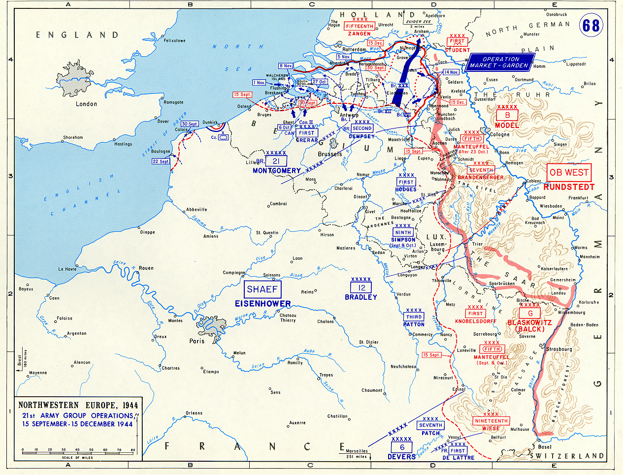
Let's look at Antwerp (refer to map.). Huge port. Capacity when it works of about 25,000 tonnes per day (estimated). Distance from Dieppe to Montgomery's 21st Army Group is roughly 350 km. Port capacity is about realistically? 5000 tonnes/day. In a related debacle due to unforeseen mechanical issues, 21st Army Group is short on trucks (1400 of them), about 3000 tons/day division supply or 1 whole corps short of allotted minimum combat tonnage/day use. Another part of the tonnage not getting to the troops is called haulage waste in civilian circles, but that is a truck's life hours being burned up, the additional man hours maintenance used per kilometer traveled, the truck driver not being used efficiently, and the fuel burned being used to haul beans, bullets and bodies back and forth, instead of being poured into a Bren carrier or a Sherman and pointed at the Germans. About 7 days in time as one measures it from Dieppe to the guys up there near the Albert Canal.
Antwerp is 3 DAYS and less than half the overland distance. That means a couple of things. Obviously supply gets to 21st Army Group much faster, but it also means their truck shortage DISAPPEARS. They are not as supply starved.
LOGISTICS: distance, time, haulage calculations. FORCE MULTIPLIER: if you can save time and wear and tear and round trips to bring it from Antwerp forward instead of hauling it all the way from Dieppe. Even if you could over the beach from Ostend it would help enormously by cutting down the time.
Logistics actually wins wars. Do it right and it wins wars faster.
<<<<<<<<<<<<<<<<<<<<<<<<<>>>>>>>>>>>>>>>>>>>>>>
You know if Horrocks had cleared Arnheim, I think Montgomery might have tried to bag 15th Army by using the Rhine as a right flank guard and driving north? It is the smart move for the winter, despite all those rivers. He's not going to get into Germany before 1945 anyway and it would be something to do that makes some sense within his available means, seeing as how he still does not have the Scheldt cleared.
") ). Montgomery did not need Antwerp for 21st Army Group supplies - Dieppe and Bolougne were enough for his needs.
). Montgomery did not need Antwerp for 21st Army Group supplies - Dieppe and Bolougne were enough for his needs.