Was Gavin to blame for the failure of Market Garden?


  • Total voters
    173
  • Poll closed .

McPherson

Banned
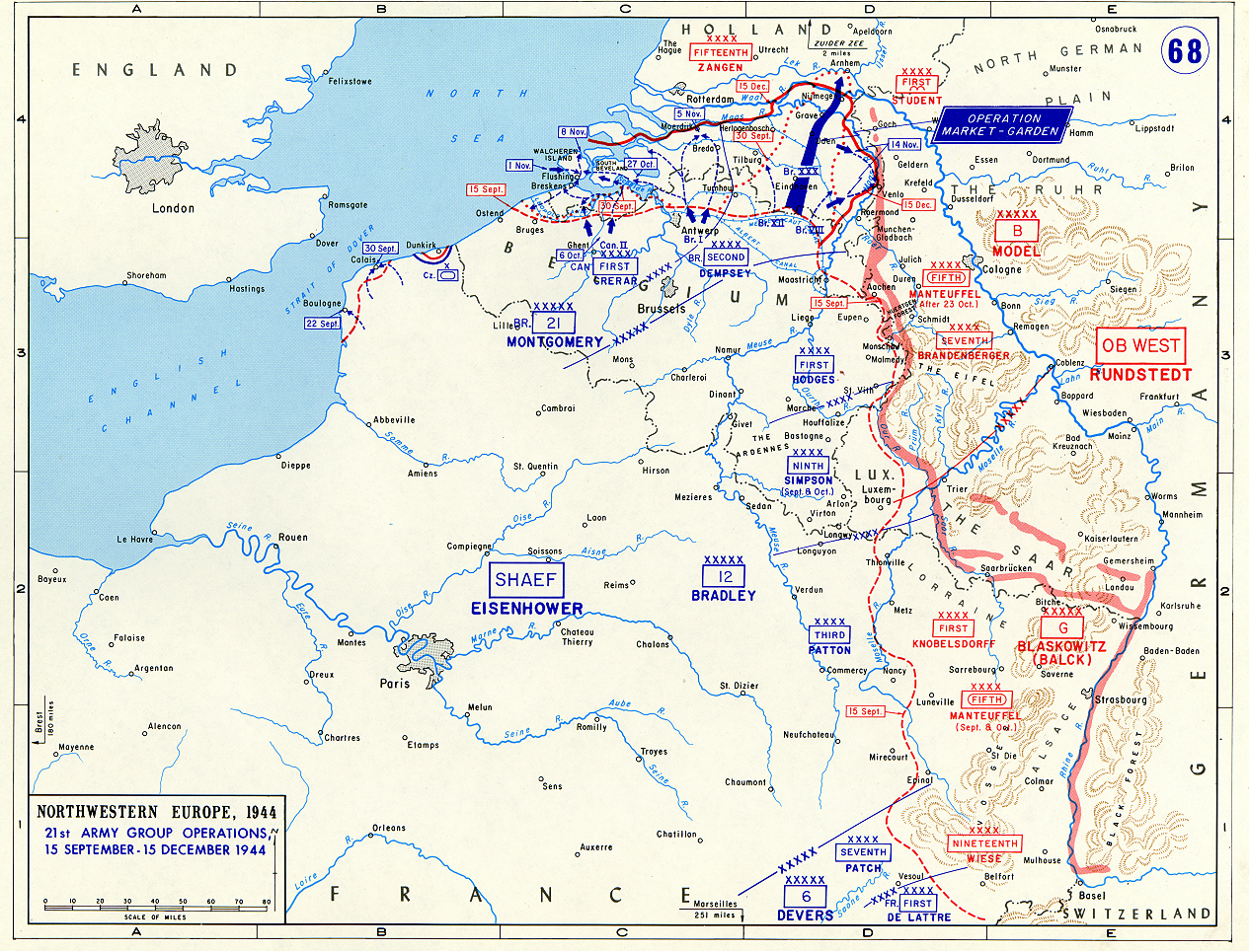
If it works MG bypasses the West wall (highlighted in the map below).

Allows the potential for the Ruhr to be overrun and this would have starved the German army of most of its tank, Artillery and aircraft production and if this was not achievable (because of 'Germans') it lengthens the Western front considerably forcing the German army to defend a much longer front line - forcing them to use forces from teh Eastern front (and / or forces used in 'Watch on the Rhine' instead of conducting a counter attack through the Ardennes)

Traps 15th Army (or forces it to bug out leaving much of its heavy kit and supplies behind)

Overruns V2 sites threatening London

Liberates most if not all of the Netherlands

Isolates the Sheldt anyway (which could not be brought into operation much before it was, even had Monty focused more on it) allowing it to be isolated/besieged/assaulted by the Canadian army and commandos (once they had been RnR'd - they had all just been pulled off the line on or about 1st Sept - most having fought since D-Day so they were not going to be available much before late Oct anyway and Walcheren Island is not going to be taken without them)

As for the truck issue - the 1400 trucks didn't simply all suddenly stop running on the same day - it was simply that the engines did not last as long as expected due to the incorrect piston rings and only a few hundred were in the workshops at any given time - and to put this into context - the UK built 1.5 million vehicles during WW2 - a figure only exceeded by the USA.

The major issue with opening up the Scheldt earlier is the demarcation lines between the British 2nd army and the Canadian 1st Army - this resulted in the Canadians having to do too much as it turned out.

I think it was Carl that in another thread suggested that 'with hindsight' the demarcation lines move north of Antwerp/Ghent (once the Antwerp had been taken on the run on or about 4th Sept - note that Ghent does not fall till Oct 6th) giving some of the responsibility to British units and reducing the subsequent burden on the Canadian army and give freedom to British units and their commanders to act more decisively and to take greater advantage of the quick advance in the first week of Sept.

I am not sure if this should be a 21st Army group decision or one made at SHAEF?

I am certain that it would be unlikely to result in an immediate collapse of the German Army had it worked - but it would be starved it of much of the equipment that those factories produced in the 6 months between Oct and March which would have resulted in a faster collapse than OTL and this or even the greatly lengthening the front that the German army had to cover would have been of far greater benefit to the allied cause than freeing up Antwerp potentially a couple of weeks earlier.

So far from Monty not being able to read a map - I think he was just fine and had his eye on a far larger goal.

Ww2_map68.jpg

Uhmm.

1. Not just the numbers of trucks, the kinds of trucks. British equivalent to the American 2 and 1/2 tonners. ATV cargo haulers.
2. The boundary question is a separate issue, but if you move the boundary, and put British units into clearing the Scheldt you decrease already scarce exploitation forces for MG. By at least a corps by what I think is suggested.
3. No way is anybody going to encircle the Ruhr from that position where the Lek runs into the Rhine.

3590370240_eb06a33c51.jpg


You can turn north and advance across the Polders. You need lots of assault boats and bridging, cause it is Holland and they are Germans. East? (Reichswald) Forget it. This is what I mean by Montgomery not being able to read a map.

p14(map).jpg


As for the American view of what is happening? Let us just say the American military understood that CHURCHILL could not read a map.
 
I'm gonna add these maps to show that the east of the Netherlands is not the same type of battleground as the west:
40.jpg
Inundatiegebieden_ten_tijde_van_de_bevrijding.png

The NAP is the average level of the sea. Rivers sometimes lie a bit higher especialy in the winter and that's the reason areas near rivers need dikes and can be also for defensive reasons be inundated. In the area east of Arnhem there were in 44-45 inundations, but those aren't as deep and effective as those in the west. The water simply flowed away again through the ground and minor streams.
 
By bouncing across at Arnhem you are north of the Lek which was the entire point of the op

And you links are confusing?

East? (Reichswald) Forget it.

http://www.konejung-stiftung.de/pic/maps/Karte_Schlacht-ums-Rheinland_44_45.jpg

So this map shows the incredibly difficult terrain that MG tried to avoid and that led to the Hurtgen forest debacle and the fighting around Aachan and if anything shows why it was prefferable to go around it to the north

This is what I mean by Montgomery not being able to read a map.

https://www.historynet.com/battle-o...ision-suffered-in-the-heavily-armed-woods.htm

That was Hodges under command of Bradley? Not sure what that has to do with Montys map reading skills?

The last link - you are fixated on map reading skills ;)

Everyone seems to accept that the Italy campaign was a dead end but all seem to forget that it knocked Italy out of the War, opened up a 2nd front to show the Russians that the Wallies were 'in it' well before they could do Normandy and opened up the Med for business.

So again - it served its purpose but was not going to be a war winner on its own.

That being said I believe that Churchill was surplus to requirements post 1942 and prior to that interfered far too much (and more importantly was allowed to interfere before Allanbrooke firmly sat on him - his war Diary is an eye opener!)

Once France was invaded it became a secondary theatre and quite rightly so.

Dragoon was possible because of Normandy and would not have been feasible at or before 5th June. But was absolutely correct following it.

I appreciate that you lost a family member in Italy - sadly there was a lot of it about I lost one fighting in Normandy.

But I blame a drug addled German Megalomaniac and the fanatics that followed him.
 

McPherson

Banned
I'm fixated on logistics, road nets, terrain and basic map-reading skills.

In order:

1. North of the Lek is still drowned floodable land. You are trying to turn east..

57813_fullimage_1235-deventer%20ijsselaanzicht%20-%20copyright%20salland%20marketing%20%287%29.jpg%21%281200-800%29.jpg


Deventer, Holland.

2. The incredibly difficult terrain had to be taken and the turn was south of Nijmegen RTL anyway. That is why I supplied the cite.

3. Hodges fought in the kind of buzz-saw that Montgomery was trying to turn into.

4. I have actually covered Italy, here.

Quoting me....

the RN experienced staggering losses in submarines by a RM who was far better in ASW than the IJN. In that case also were too few submarines to patrol both West and Eastern Med. Especially after the greek collapse, the british subs had to additionally operate in the Aegean with a string of Luftwaffe bases around. A number of submarines was also used in missions such as delivery of SOE agents and retrieving personnel from the continent. At the same time a number of submarines had to stay in Norwegian waters were they had a fair number of successes against the german communication lines.

You would be surprised at the blowback I receive when I write that the Italians (RM) were probably better at ASW than anyone, except maybe the Anglo-Canadians in 1940. I would not want to shave with the difference. Of course the Mediterranean Sea is a horrible submarine environment like the coastal seas off East Asia, with shallows; easy ASW aerial patrol interlocks from shore based air forces and a clarity of water that allows fliers to see shallow dived boats and good listening for noisy boats. I would say Japanese ASW 1944 was about on a per with the Italians in 1940, good, but not as good as Allied submarine operations evolved toward by that same 1944 era.

Anyway.

a) Install the full compliment of AA guns
b) Have enough ground support for air operations
c) Increase the number of fighters
d) Increase the number of reconnaissance planes (mostly Baltimores)
e) Only then build a proper bomber force.

Med1.png


The circles are what each side has. The triangles are what each side wants. Since nobody could read a map apparently, it might not be obvious that Malta is the nexus of decision? Operation Merkur hit the wrong target. Let the British have Crete, (For the moment; for they cannot stay there.). As a corollary, that long march from Alexandria to Naples has to be seaborne and supported. There is no other way to do it. And that march has to be made, for if the British lose the Mediterranean (See the airpower fix they are geographically in?), the Allies lose the war. Hitler's armies don't even have to get further than Egypt. Cutting the canal is enough.

I will point out that Tunis had to be taken from the west because the RN in the eastern Mediterranean did not have the power or ability to sea guard Montgomery's advance. Similarly the Desert Air Force was not strong enough. Logistics lay at the heart of it, as it does for most military capabilities and options. But you have to understand the overall battlespace to understand the logistics limits and to isolate the nodes of decision. (Allies TUNIS. Allies NAPLES. Allies FOGGIA airfields. Anything beyond that in Italy was gross stupidity.)
----------------------------------------------------------------------------------------------------

In September of 1944 as the Anglo-Americans approach the German frontier, the port-denial plan the Germans implemented brought about the very situation where Antwerp would be the Decision Nexus, not the MG operation. Barring Antwerp cleared, the grand narrow thrust into Germany was an act of military insanity. You cannot supply it. And given the terrain? North of the Ruhr, forested high ground. South of the Ruhr, forested high ground. The good going? Kill funnel pointed straight at Cologne with Germans on the flanks. Nobody should have been happy at SHAEF on 15 September 1944, because where is 21st Army Group going to go, given their geographical situation, their supply crisis, and the lack of an exploitation plan post Arnheim? One direction.... NORTH.
 
1. North of the Lek is still drowned floodable land. You are trying to turn east..
No, it's not. And I lived there for most of my life. In a town between Arnhem and Deventer.

(And at Arnhem it's actually called the (Lower) Rhine. It becomes the Lek about 30 km west of Arnhem).
 
: I did have a book called 'with the Scots' that was a war diary kept by a platoon commander in one the 52nds Infantry Battalions. His units worst day was during the advance into Germany in 45 when their position was fired on by a platoon of M10s with 17 pounder and 50 cal fire due to map mix up resulting in 2/3rd of his platoon being killed or wounded. I no longer appear to have it.
Peter White: With the Jocks.

White was with 4/KOSB. The incident you mention was on 5 April 1945, outside Riesenbeck -
'It was three of our own tanks, Pete, worse luck; SP 17-pounders firing from back over those fields beyond our farm. ...they took you for Jerries. They'd been told we'd been held up, but had the wrong buildings marked as enemy on their map...the troop commander's in a bad way. He collapsed when he realised what he had done'*

11 KIA, 12 WIA, including members of an RA FO party.

See p301-06, Sutton ed, 2006 pb.

*He was killed by a mine later that same day.

I recommend this book, really excellent on the grim realities of infantry combat.
 
Last edited:
All I have is history. Montgomery's only move is still NORTH.
You don't want to go north. Directly north of Arnhem there's dense forest and it's quite hilly. It's worse than the forest near Nijmegen.

The flood prone markings on your map are about the flooding of the rivers after heavy rainfall upstream. This usually happens in the first months of the year. The dark blue patch on your map south of Arnhem, is the evacuation zone in january 1995.

The light blue patches are the uiterwaarden along the river IJssel (the one going north from Arnhem) also regularly flood in those months. As @H.Flashman(VC) already mentioned, there were inundation, but those were not as effective as the Waterlinie in the west of the country. The water simply flows back to the river. So if the waterlevel in the river is normal, it won't be effective.
 
@McPherson

https://nl.m.wikipedia.org/wiki/Nederrijn
https://en.m.wikipedia.org/wiki/Lek_(river)
So, the part you're talking about is called the Nederrijn. I admit it's confusing even for locals (I live next to the Lek)
Yes, as a kid I always wondered about the rivernames.

I also wondered why they always said that the objective of MG was to turn east from Arnhem. Because from Arnhem, then you have to cross the river IJssel, the taking of those bridges wasn't incorporated in the plan. So @McPherson has got a point there. Although the river IJssel is not nearly as wide as the Rhine, so I presume it will be less of a barrier.

Going north/northeast along the IJssel won't be funny. It's a narrow strip of flat land between the hills and forest of the Veluwe and the IJssel. Going straight north towards Apeldoorn, I would not recommend. There are few roads through the forest.
 
The buck stopped with him, which he acknowledged. Some years later, Ike wrote: "I not only approved MARKET-GARDEN, I insisted on it."

Yes Ike had ordered the attack into the Ruhr area - everyone From SHAEF down wanted to bounce the Rhine.

It was only when things bogged down West of the Westwall with the actions around Aachen, Hurtgen etc and the failure of MG that he ordered Monty to concentrate on clearing the Scheldt and to focus on opening Antwerp for business.
 
What if it was not GEN Montgomery's plan (In my opinion, YMMV; faulty concept of operation.), but GEN Gavin at Nijmegen who screwed everything up with not immediately assaulting Nijmegen bridge at once, instead of concentrating on the Groesbeek Heights drop zones defense? Just where did that critical 36 hour delay occur that resulted in the Arnheim disaster?
McP.


I just recently read William F. Buckingham's "Arnhem: The Complete Story" and he makes the case that it was Browning who insisted on the major effort on the first day being directed at Groesbeek Heights. According to Buckingham, Gavin disagreed with this but could not contradict a direct order; he did try to more or less hint to one of his regimental commanders to focus more on the bridge, but the hint was not taken. Overall, Buckingham assigns the blame for Market-Garden's failure to Browning for poor planning and being more concerned with being in on the action and therefore establishing a reputation as an airborne expert, hence the unnecessary headquarters lift on the first day.

Buckingham is also very critical of Urquhart, who was out of his depth as an airborne division commander, and whose poor planning resulted in the Arnhem road bridge being seized by just Frost's reinforced battalion where the opportunity to seize it with a whole brigade existed.

Finally, it seems XXX Corps didn't have much of a sense of urgency in its operations. I don't have nearly enough knowledge to judge whether this is at all correct, but the book certainly makes a convincing case.
 

McPherson

Banned
You don't want to go north. Directly north of Arnhem there's dense forest and it's quite hilly. It's worse than the forest near Nijmegen.

One has to think about that one, but one also has to think about what can be done with the supply, with the terrain, the remaining assets and the mobility limits. Maybe the ground is tougher going for 40 km, but also maybe the tactical march limit into this bound is only 200 km and one has burned up about 30% of the committed troops, machines, the other supplies and fuel clearing forward as far as Arnheim. The logic is kind of grim here that one will have to move into a situation where the exploitation has to be achievable on what is left of the men, machines and supplies . Given optimistically that one only has about 140 km left and that the Germans will be beyond desperate, the good move, might be to drive for the sea and scream for help. How well defended are the West Friesian islands and is there any assault shipping and a spare division for Texel? Supply by sea is always the goal for me to shorten round trip times for Montgomery. That and maybe to set up for the winter that is coming to the Western Front.

Sherman is the lesson here, not Mannstein. Think and fight like a SEAPOWER.

The flood prone markings on your map are about the flooding of the rivers after heavy rainfall upstream. This usually happens in the first months of the year. The dark blue patch on your map south of Arnhem, is the evacuation zone in January 1995.

I did not know that. Weather now enters into the equation and that makes the move north even more emphatically a good option. One might want to think that far ahead as to the allied logistics picture during the winter.

The light blue patches are the uiterwaarden along the river IJssel (the one going north from Arnhem) also regularly flood in those months. As @H.Flashman(VC) already mentioned, there were inundation, but those were not as effective as the Waterlinie in the west of the country. The water simply flows back to the river. So if the waterlevel in the river is normal, it won't be effective.[/QUOTE]

So one wants to be east of that event? I'm thinking about it

Yes, as a kid I always wondered about the rivernames.

I also wondered why they always said that the objective of MG was to turn east from Arnhem. Because from Arnhem, then you have to cross the river IJssel, the taking of those bridges wasn't incorporated in the plan. So @McPherson has got a point there. Although the river IJssel is not nearly as wide as the Rhine, so I presume it will be less of a barrier.

Going north/northeast along the IJssel won't be funny. It's a narrow strip of flat land between the hills and forest of the Veluwe and the IJssel. Going straight north towards Apeldoorn, I would not recommend. There are few roads through the forest.

Might have to risk it anyway.

Here's what I think. Pick it apart.

Holland2.png


Is it doable, provided Arnheim is cleared?
 
Why the fuck would you want to go to Texel? That's not a warwinning move. It has a very small harbor, which is in clear view (and artillery range) from den Helder. Apart from that, if you want to use it for logistical reasons, you're gonna have to deal with the Waddensee, which falls mostly sorta dry during low tide. You're not gonna supply a lot from there.* There's a reason why the north of the Netherlands was only liberated in april/may 1945.

Your arrow from Arnhem (it's without the i, that would be the German name) towards Deventer goes exactly through the most difficult terrain. You need to follow the railway and road that is on the map. The land is flat between the river and the railway, but it's a really narrow until Dieren, about 15 km NE of Arnhem. It's a real bottleneck, and from the 'heights' near Rheden** you've got a nice view of what is happening in that strip. For the most part it's (a lot) less than a kilometre between the highest points and the river.
Or alternatively, make your push from Ede northwards. Terrain is more suitable there.

What you really want to do, is turn east, towards Germany's heartland. Once you've cleared river the IJssel, it's flat and open country. So you want to cross the IJssel near Arnhem, or the Rhine between Arnhem and where the Waal separates from it. But what always amazed me, was that the IJssel bridges near Arnhem weren't included in the plan. But maybe they gathered the IJssel is not wide enough to pose any real problems crossing it once they've gotten a goot foothold in Arnhem.

* The Frisian Islands option is not one that goes down well in this forum.
** they're only about 80-100 meters above sealevel, so not really high. I've been there often, and it gives you a nice view of the river IJssel and uiterwaarden.
 
One has to think about that one, but one also has to think about what can be done with the supply, with the terrain, the remaining assets and the mobility limits. Maybe the ground is tougher going for 40 km, but also maybe the tactical march limit into this bound is only 200 km and one has burned up about 30% of the committed troops, machines, the other supplies and fuel clearing forward as far as Arnheim. The logic is kind of grim here that one will have to move into a situation where the exploitation has to be achievable on what is left of the men, machines and supplies . Given optimistically that one only has about 140 km left and that the Germans will be beyond desperate, the good move, might be to drive for the sea and scream for help. How well defended are the West Friesian islands and is there any assault shipping and a spare division for Texel? Supply by sea is always the goal for me to shorten round trip times for Montgomery. That and maybe to set up for the winter that is coming to the Western Front.

Sherman is the lesson here, not Mannstein. Think and fight like a SEAPOWER.


I did not know that. Weather now enters into the equation and that makes the move north even more emphatically a good option. One might want to think that far ahead as to the allied logistics picture during the winter.

The light blue patches are the uiterwaarden along the river IJssel (the one going north from Arnhem) also regularly flood in those months. As @H.Flashman(VC) already mentioned, there were inundation, but those were not as effective as the Waterlinie in the west of the country. The water simply flows back to the river. So if the waterlevel in the river is normal, it won't be effective.

So one wants to be east of that event? I'm thinking about it


Might have to risk it anyway.

Here's what I think. Pick it apart.

Holland2.png


Is it doable, provided Arnheim is cleared?[/QUOTE]

No the plan was to effectively by pass the Rhine and occupy the Ruhr - which was the Detroit of Germany

This had the operation been successful would have denied the German army of a large % of its principle war industry

The chances are that they would have moved as fast as they could (which was generally quite fast) to block the attack - but even if they were successful it still basically fucks them up as the forces used to stop 21st Army group would have to be taken from elsewhere so would weaken other fronts.

Who knows - but I suspect that the initial forces would have to come from Models Army group B (5th and 7th army's) opposite Hodges and Simpsons 1st and 9th US Army's as they are the closest and may do much to eliminate the heavy fighting that took place in the lead up to and during the Ardennes offensive.

Instead we may see Bradleys army group - his divisions not 'weakened' by the OTL heavy fighting during Oct - Dec closing up with the Rhine before Christmas and possibly crossing it.

Forces might also be withdrawn from the Eastern Front with implications there as a result.
 

McPherson

Banned
Why the fuck would you want to go to Texel? That's not a warwinning move. It has a very small harbor, which is in clear view (and artillery range) from den Helder. Apart from that, if you want to use it for logistical reasons, you're gonna have to deal with the Waddensee, which falls mostly sorta dry during low tide. You're not gonna supply a lot from there.* There's a reason why the north of the Netherlands was only liberated in april/may 1945.

Your arrow from Arnhem (it's without the i, that would be the German name) towards Deventer goes exactly through the most difficult terrain. You need to follow the railway and road that is on the map. The land is flat between the river and the railway, but it's a really narrow until Dieren, about 15 km NE of Arnhem. It's a real bottleneck, and from the 'heights' near Rheden** you've got a nice view of what is happening in that strip. For the most part it's (a lot) less than a kilometre between the highest points and the river.
Or alternatively, make your push from Ede northwards. Terrain is more suitable there.

What you really want to do, is turn east, towards Germany's heartland. Once you've cleared river the IJssel, it's flat and open country. So you want to cross the IJssel near Arnhem, or the Rhine between Arnhem and where the Waal separates from it. But what always amazed me, was that the IJssel bridges near Arnhem weren't included in the plan. But maybe they gathered the IJssel is not wide enough to pose any real problems crossing it once they've gotten a goot foothold in Arnhem.

* The Frisian Islands option is not one that goes down well in this forum.
** they're only about 80-100 meters above sealevel, so not really high. I've been there often, and it gives you a nice view of the river IJssel and uiterwaarden.

Because I'm interested beyond Texel and the West Frisian Islands. The West Frisian islands have to be cleared for over the beach operations near Harlingen, (despite the tidal problems, use Alligators, LSTs, and DuKWs if you have to lighter the loads across.)and you don't have the gas, food, bullets, machines and men, to punch into Germany, until you shorten Montgomery's 21st Army supply route. THAT's why.

2001082501.jpg
 
Top