You are using an out of date browser. It may not display this or other websites correctly.
You should upgrade or use an alternative browser.
You should upgrade or use an alternative browser.
Map Thread XVIII
- Thread starter FesteringSpore
- Start date
-
- Tags
- map thread maps
- Status
- Not open for further replies.
@Tomislav Addai coolness, but there's a strange block on the southern border of whatever's left of South Africa.
EDIT: Also, can we get an idea of the names of the new countries?
EDIT: Also, can we get an idea of the names of the new countries?
Does anyone by chance have any maps on lands German nobles had in Austria? Read recently how one of the Thuringia royal families sold Lichtenburg to Prussia so as to expand their property in Upper Austria, pulse Liechtenstein had issues for decades with the Czechs due to their property being confiscated due to them being Germans. Well, that and foreign.
LordOguzHan
Banned
I'd recommend giving credit to the original creators next time. Otherwise there's no way for us to know that this isn't your content unless we recognize it, which is plagiarism.
Ok

But Map is Me !!!!
You have your name in the corner of the box with the text. Why not wait a while for your next map? Take some ideas from your various inspirations, but combine them into something unique. We understand your joy on here, but your current maps and texts are something that would have been found on a much earlier Map Thread. Is their any part of world history you are especially interested in? If you find a unique area you can probably make something new and exciting,Ok
But Map is Me !!!!
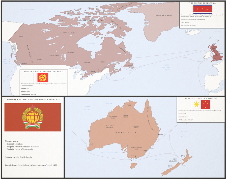
Remastered a map from a long time ago I made of a scenario originally for a contest to create a 'reverse cold war'. A map of the Commonwealth of Independent Republics, an organisation to replace part of the British Empire after the British revolution.
Reddit - https://www.reddit.com/r/imaginarymaps/comments/8z47ov/reverse_cold_war_commonwealth_of_independent/
Deviantart - https://www.deviantart.com/ap246/art/Commonwealth-of-Independent-Republics-754669501
Square at the bottom of South Africa (Capeland) is just my mistake, as I was going with eraser cleaning up tge district boundaries.View attachment 404667An alternate map of mainland Africa.
List of new countries:
- Libya: Cyrebaica(east),Tripolitania (west) and Fezzan (south). Dividing up Libya was not a problem at all, as these are all traditional regions of the country, and after Italian defeat in WW1 it was upon Britain and France to agree to this arrangement.
- Algeria: Charles de Gaulle is more willing to negotiate; he says he shall agree to an independent Algeria, as long as Oranie stays French... basically you get a Pied Noir state in the Northwest Algeria. Also de Gaulle pressed for an independent Kabylie (pink)
- Morrocco: Spanish Morrocco made into Riffian Republic
- Sudan: the British before pulling out of the area give independence dlto Darfur (west) and Equatoria (south).
- French West Africa: before granting independence, tge French carve new states of Azawad (north Mali) and Agadez (north Niger). Casamance was split from Senegal not by the French, but ten yearsvafter independence when it was evident that Gambia will not join Senegal.
- Nigeria: yes a tricky one.the Hausan republic was created from the north, while the south remained Nigeria. However, before pulling out, the British made referenda in Biafra (southeast) and Bornu (northeast) whether those areas wish to be independent. The result is visible on the map today
- Central African Republic: The Republic of Logone was carved from northern parts of the country, being a largely Muslim state
- Equatorial Guinea: has the Bioko island declared a separate country
- West Congo: The State of Loango has separated three years after decolonization.
- Zaire: Before decolonization, the Belgians divided their Middle Africa into numerous states. The largest (pink) became known as Zaire, being still an unstable country. Kivu has been given independence in the east (green), Kasai in the middle (blue-grey-green) and Katanga (yellow) in the south. The BaKongo have effectively established their independence from Zaire .
- The Portuguese split from Angola the Chokwe republic in the east and Cabinda.
- British decolonization of Kenya resulted in the east being attached to Somalia and Mombasa republic being independent
- Tanganyaka and Zanzibar remain separate
- The states of Buganda , Bunyor (west) and Acholia (east and north) comprise OTL Uganda
- Independent Barotseland was restored as the British pulled out from western Zambia.
- Rhodesia gave independence to the Bantu nations of Matabeland (west), Mashonaland (north) and Manicaland (east). The northeast potion o Rhodesia is still claimed by Mashonaland however.
- And finally, what happened to South Africa? Well ... the British restored the independence of Transvaal (Orange), Orange Free State (brownish) and the United States of Stellaland (green), Natal (light blue) were to become a separate country and Griqualand West (between Cape and Botswana) and Griqualand East (southeast of Lesotho) (both shown in the greyish green colour). The Afrikaners were unwilling to lose control of the country, so they gave independence to new countries. The enlarged "bantustans" are: KwaZulu (south of Mozambique), Xhosaland (between Cape and Griqualand East) and the Federal Republic of Azania (pink being in borgore with Tranvaal). Furthermore, large areas were ceded to Swaziland, Lesotho and Botswana.
- A similar pattern was put in place in Namibia. The independent states of Ovamboland (brown), Kavango (orange) were created to maintain Afrikaner (mostly Baster/Coloured) influence in Namibia. Caprivi strip was ceded to Barotseland even before that. The rest of Namibia has three official languages: Nama/Damara, Herero and Afrikaans.
Last edited:
I understand that, but you need to give credit to the creators of the scenario behind the map. The people who put time and effort into crafting a scenario deserve to be recognized, and the way you currently make your maps makes it come off as though you're taking credit for their work.Ok
But Map is Me !!!!
LordOguzHan
Banned
I understand that, but you need to give credit to the creators of the scenario behind the map. The people who put time and effort into crafting a scenario deserve to be recognized, and the way you currently make your maps makes it come off as though you're taking credit for their work.
Can I make a script for my cat?
So Alternate Fascist States.
This is awesome and I'd love to see more of this world! So is the CIR a confederation of some kind? Because I'm imagining a communist EU, just with a slightly stronger central government.
Remastered a map from a long time ago I made of a scenario originally for a contest to create a 'reverse cold war'. A map of the Commonwealth of Independent Republics, an organisation to replace part of the British Empire after the British revolution.
Reddit - https://www.reddit.com/r/imaginarymaps/comments/8z47ov/reverse_cold_war_commonwealth_of_independent/
Deviantart - https://www.deviantart.com/ap246/art/Commonwealth-of-Independent-Republics-754669501
LordOguzHan
Banned
Remastered a map from a long time ago I made of a scenario originally for a contest to create a 'reverse cold war'. A map of the Commonwealth of Independent Republics, an organisation to replace part of the British Empire after the British revolution.
Reddit - https://www.reddit.com/r/imaginarymaps/comments/8z47ov/reverse_cold_war_commonwealth_of_independent/
Deviantart - https://www.deviantart.com/ap246/art/Commonwealth-of-Independent-Republics-754669501
Very Nice map
What?Can I make a script for my cat?
So Alternate Fascist States.
This is awesome and I'd love to see more of this world! So is the CIR a confederation of some kind? Because I'm imagining a communist EU, just with a slightly stronger central government.
Thanks! Yeah, when I made it, I orginally envisaged it as a kind of confederation in that way. I did focus on this project for a while, but never that much (like Thousand Week Reich or something) and I eventually moved on. Maybe one day I'll go back to it, I don't know
Does this exist in the same universe as your Russian Soviet Republic on DeviantArt?Thanks! Yeah, when I made it, I orginally envisaged it as a kind of confederation in that way. I did focus on this project for a while, but never that much (like Thousand Week Reich or something) and I eventually moved on. Maybe one day I'll go back to it, I don't know
Does this exist in the same universe as your Russian Soviet Republic on DeviantArt?
No, that was a one off. This map was made long before that and remastered recently. If you go to the reddit post linked and follow the links i think you can find other maps in the series. I'd be more direct in linking but I'm on mobile on holiday I'm afraid.
Neat collection! So the British are the opponents to a Russian Empire that seemed to go through a Russian Civil War but maintained the Tsar, right?No, that was a one off. This map was made long before that and remastered recently. If you go to the reddit post linked and follow the links i think you can find other maps in the series. I'd be more direct in linking but I'm on mobile on holiday I'm afraid.
Skallagrim
Banned
Just finished the write-up, so allow me to give you: the world of my previous map (posted last Saturday), filled in with some actual people. The base-map for Eurasia is @hadaril's NextGen OTL Worlda map, version 3.0, for the year 814 AD. I have edited it considerably, firstly because I use SUCK (which employs both different colours and different conventions for denoting certain types of borders, territorial status etc.), secondly because I have some different preferences when it comes to showing non-state tribal cultures, and thirdly because I think some borders were slightly different back then. (Update: using a Q-Bam created by @LSCatilina as reference, I have since edited my take on Eurasia a little in some places, hopefully providing greater historical accuracy.)
Anyway, Eurasia and Africa are all as in OTL, so no explanations needed for what we see there. The Western Hempisphere, obviously, is not as in OTL. I'm still working on refining the various cultures of the New World, and haven't named all of them yet, so no legend at the moment. The write-up will make rather clear what's what (at least regarding the relevant bits.)

The year 814, at least by the calendar of the Christians. A year noted for the passing of Charlemagne, which marks the beginning of the end when it comes to the unity of his Empire. A twist of fate allows it to be inherited by a single heir for the moment, but soon it will be divided, per the customs of the Franks. Elsewhere in Eurasia, the Abbasid Caliphate has also entered its terminal decline, as has the empire of the Tang Dynasty. Many states rise and fall, but it is remarkable that the decline and fall of three long-ascendant empires should happen to co-incide. Three? No. Five. For beyond the edges of the world the aforementioned peoples know, other empires exist... for now.
The Eurasians know nothing of this. Long ago, in the latter days of the last great Ice Age, some distant relatives of theirs crossed the Bering Bridge and found their way to a new world. When the ice receded and the land connection was broken, they became isolated from all others. And in isolation, they prospered. They had stumbled upon a Continent-Archipelago, a vast group of large island (and many smaller ones), separated by twisting straits and encircling their very own Middle Sea. Those who found this New World had never laid eyes upon the Mediterranean, but if they had, they would have found the sight familiar.
Arriving in the North-West, they soon began to spread out over these insular territories, forming chiefdoms in increasing complexity and size. Connected by the waterways, the development of naval traditions and trade networks was practically inevitable. As was, of course, the clash of navies and the plague of piracy. Using ever more refined ships, they made this world their own. Some settled around the Middle Sea, in equal measure enjoying the favourable trade winds and suffering the stormy months, when hurricanes annually blew in from the south. Others settled on the exterior coasts and the Outer Isles that stretch along them. Some stayed in the far north, closer to the ice-sheets, far away from all the southern agitations. And some travelled beyond the reaches of the Middle Sea, out onto the chains of islands to its south, with their warmer, humid climes. There were even those who went as far as the great continent to the South, making a home there and never looking back.
Chiefdoms evolved into kingdoms, although most, at this point in time, remain very much like those of the Gauls, the Germans, the Dacians and other such peoples that the Greeks and Romans encountered to their north and considered barbaric. Somewhere between tribal pacts and feudal kingdoms. But there are two great exceptions, and they are based first and foremost on trade. The Middle Sea and the Southern Isles both form natural trade networks, and in both, one power—with superior ships and numbers—eventually overcame all rivals and established dominance. Both having resources the other did not, these empires eventually settled on a border between them, and began to trade with one another. There is no love lost between them, but at least they can both look down on the uncouth peoples who live outside their domains.
If only they knew the price that is exacted for such haughtiness! In this year, in which the Franks of Europe lost their Emperor, the Great Nakkaroweng, encircling the Middle Sea, has lost its last great Empress, Ahannakwer VII. Her third daughter and anointed heir, Menokweret (soon to rule as Amenokwer III), is far from capable. In times of easy prosperity, this would have been no problem. These are not such times. The empire has long been in decline, and most of its war-ships are now manned by crews mostly recruited from the barbarian peoples— men who have little regard for the traditions of the Nakkarau. They do not care that there are customs for a reason, that woman rule the land and men command the navies for a reason. The ambitious admiral Hiperrok, born on the western isles among the Obasirosh, is quite certain that he could succeed, if he were to make a play for the golden mantle...
What he does not fully understand—ironically because he is a "barbarian" from outside the empire—is that empires run, to a great extent, on their reputations. If one barbarian can seize the divine golden mantle of Kelaupek, so can any barbarian. Hiperrok will succeed in his plans. He will also die by a rival's arrow not that long after. His very success in usurping power will invite a long line of would-be despots, and their wars will tear an empire to shreds. A hundred years from now, there will be no more Great Nakkaroweng. Only quarreling fiefs.
The end of the Solemnly Bound Ports and their sprawling trade-empire to the south is to be less poetic. Despite all their silver-tongued promises of mutual amity, all seven great city-states would happily destroy the other six and rule alone. All are gearing up their navies for war, and have been doing so for the better part of two decades. This has happened many times before. Every time until now, it has resulted in some lesser ports changing hands, some reparations and indemnities paid, and then a return to peace and trade. This time will be different. The decline of Nakkaroweng, and the ascent of trading partners on the southern continent, has gradually upset the balance. The southernmost three of the Bound Ports are now richer together than the other four, and that trend looks likely to continue. When Nakkaroweng finally collapses to usurpation, the northern four Ports will try a desperate attempt to vassalise some former imperial territories to their north, in an attempt to gain access to the markets of the Middle Sea.
This will cause the civil war that pits the two factions within the Bound Ports against each other. When Xidaulot unexpectedly switches sides, both sides will lose faith in the trustworthiness of their alliances. A few years later, it will be a war of all against all. The unity of the Bound Ports will not be restored this time, and the various city-states will not coalesce into leagues again. Instead, they will be an increasing tendency towards despotism and kingship— something the Ports have until now rejected vehemently.
The coming century will see, then, the collapse of three empires in the Old World, and two in the New. But it will be several more centuries before the Old and the New World finally make contact. Both will have plenty of time to recover from these imminent upheavals. When the hemispheres finally become aware of each other's existence, it will be an interesting time indeed. Then the world will witness true upheavals.
Anyway, Eurasia and Africa are all as in OTL, so no explanations needed for what we see there. The Western Hempisphere, obviously, is not as in OTL. I'm still working on refining the various cultures of the New World, and haven't named all of them yet, so no legend at the moment. The write-up will make rather clear what's what (at least regarding the relevant bits.)
The Waning of Five Empires
The year 814, at least by the calendar of the Christians. A year noted for the passing of Charlemagne, which marks the beginning of the end when it comes to the unity of his Empire. A twist of fate allows it to be inherited by a single heir for the moment, but soon it will be divided, per the customs of the Franks. Elsewhere in Eurasia, the Abbasid Caliphate has also entered its terminal decline, as has the empire of the Tang Dynasty. Many states rise and fall, but it is remarkable that the decline and fall of three long-ascendant empires should happen to co-incide. Three? No. Five. For beyond the edges of the world the aforementioned peoples know, other empires exist... for now.
The Eurasians know nothing of this. Long ago, in the latter days of the last great Ice Age, some distant relatives of theirs crossed the Bering Bridge and found their way to a new world. When the ice receded and the land connection was broken, they became isolated from all others. And in isolation, they prospered. They had stumbled upon a Continent-Archipelago, a vast group of large island (and many smaller ones), separated by twisting straits and encircling their very own Middle Sea. Those who found this New World had never laid eyes upon the Mediterranean, but if they had, they would have found the sight familiar.
Arriving in the North-West, they soon began to spread out over these insular territories, forming chiefdoms in increasing complexity and size. Connected by the waterways, the development of naval traditions and trade networks was practically inevitable. As was, of course, the clash of navies and the plague of piracy. Using ever more refined ships, they made this world their own. Some settled around the Middle Sea, in equal measure enjoying the favourable trade winds and suffering the stormy months, when hurricanes annually blew in from the south. Others settled on the exterior coasts and the Outer Isles that stretch along them. Some stayed in the far north, closer to the ice-sheets, far away from all the southern agitations. And some travelled beyond the reaches of the Middle Sea, out onto the chains of islands to its south, with their warmer, humid climes. There were even those who went as far as the great continent to the South, making a home there and never looking back.
Chiefdoms evolved into kingdoms, although most, at this point in time, remain very much like those of the Gauls, the Germans, the Dacians and other such peoples that the Greeks and Romans encountered to their north and considered barbaric. Somewhere between tribal pacts and feudal kingdoms. But there are two great exceptions, and they are based first and foremost on trade. The Middle Sea and the Southern Isles both form natural trade networks, and in both, one power—with superior ships and numbers—eventually overcame all rivals and established dominance. Both having resources the other did not, these empires eventually settled on a border between them, and began to trade with one another. There is no love lost between them, but at least they can both look down on the uncouth peoples who live outside their domains.
If only they knew the price that is exacted for such haughtiness! In this year, in which the Franks of Europe lost their Emperor, the Great Nakkaroweng, encircling the Middle Sea, has lost its last great Empress, Ahannakwer VII. Her third daughter and anointed heir, Menokweret (soon to rule as Amenokwer III), is far from capable. In times of easy prosperity, this would have been no problem. These are not such times. The empire has long been in decline, and most of its war-ships are now manned by crews mostly recruited from the barbarian peoples— men who have little regard for the traditions of the Nakkarau. They do not care that there are customs for a reason, that woman rule the land and men command the navies for a reason. The ambitious admiral Hiperrok, born on the western isles among the Obasirosh, is quite certain that he could succeed, if he were to make a play for the golden mantle...
What he does not fully understand—ironically because he is a "barbarian" from outside the empire—is that empires run, to a great extent, on their reputations. If one barbarian can seize the divine golden mantle of Kelaupek, so can any barbarian. Hiperrok will succeed in his plans. He will also die by a rival's arrow not that long after. His very success in usurping power will invite a long line of would-be despots, and their wars will tear an empire to shreds. A hundred years from now, there will be no more Great Nakkaroweng. Only quarreling fiefs.
The end of the Solemnly Bound Ports and their sprawling trade-empire to the south is to be less poetic. Despite all their silver-tongued promises of mutual amity, all seven great city-states would happily destroy the other six and rule alone. All are gearing up their navies for war, and have been doing so for the better part of two decades. This has happened many times before. Every time until now, it has resulted in some lesser ports changing hands, some reparations and indemnities paid, and then a return to peace and trade. This time will be different. The decline of Nakkaroweng, and the ascent of trading partners on the southern continent, has gradually upset the balance. The southernmost three of the Bound Ports are now richer together than the other four, and that trend looks likely to continue. When Nakkaroweng finally collapses to usurpation, the northern four Ports will try a desperate attempt to vassalise some former imperial territories to their north, in an attempt to gain access to the markets of the Middle Sea.
This will cause the civil war that pits the two factions within the Bound Ports against each other. When Xidaulot unexpectedly switches sides, both sides will lose faith in the trustworthiness of their alliances. A few years later, it will be a war of all against all. The unity of the Bound Ports will not be restored this time, and the various city-states will not coalesce into leagues again. Instead, they will be an increasing tendency towards despotism and kingship— something the Ports have until now rejected vehemently.
The coming century will see, then, the collapse of three empires in the Old World, and two in the New. But it will be several more centuries before the Old and the New World finally make contact. Both will have plenty of time to recover from these imminent upheavals. When the hemispheres finally become aware of each other's existence, it will be an interesting time indeed. Then the world will witness true upheavals.
Last edited:
- Status
- Not open for further replies.
Share: