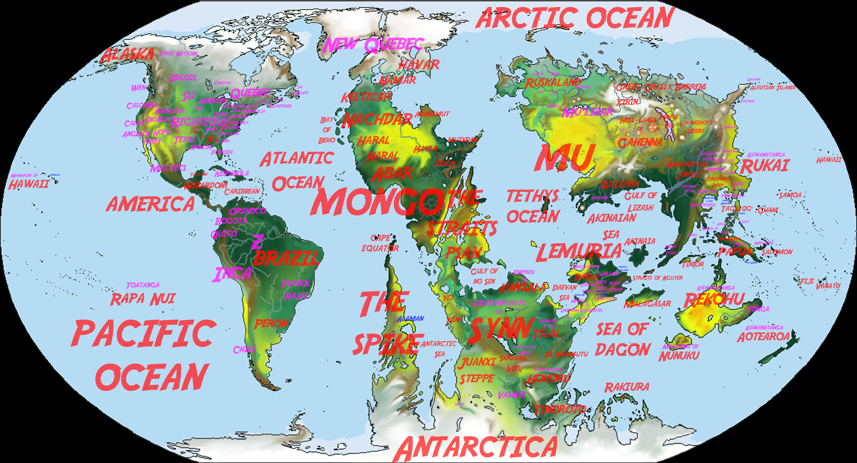
A bit of border gore, but looks crazy. :V
That's what happens when fractal geography meets random claim lines.
A bit of border gore, but looks crazy. :V
Here is a map of arable land by country as of 2013.
A bit of border gore, but looks crazy. :V
WIP of a North American scenario I've been working on in Inkscape (no PoD in particular, just a lot of brutally murdered butterflies).

Here is a map of arable land by country as of 2013.
]
Trust me, Civcraft is insane. Started playing it last year, very crazy server in my opinion. I'm from Kaiserinreich (together with M.R.L. and AshleeNova). We're currently planning stuff for the server reset, too.
All I know is that I'm in love.
Never did get around to visiting either iteration of Kaiserin, far away as you are from most of the world. You guys joining up with any other groups for 3.0?
Never did get around to visiting either iteration of Kaiserin, far away as you are from most of the world. You guys joining up with any other groups for 3.0?

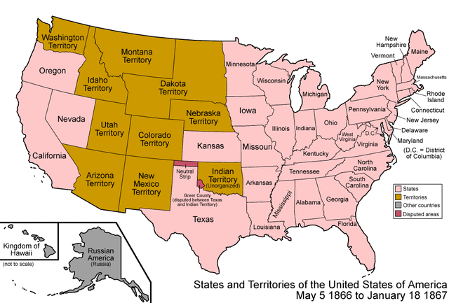
"The Annexation Bill of 1866 was a bill introduced on July 2, 1866, but never passed in the United States House of Representatives. It called for the annexation of British North America and the admission of its provinces as states and territories in the Union."
Article IV declared that the "Territorial divisions are established as follows:
(1) New Brunswick, with its present limits;
(2) Nova Scotia, with the addition of Prince Edward Island;
(3) Canada East, with the addition of Newfoundland and all territory east of longitude eighty degrees and south of Hudson's strait;
(4) Canada West, with the addition of territory south of Hudson's bay and between longitude eighty degrees longitude ninety degrees;
(5) Selkirk Territory, bounded east by longitude ninety degrees, south by the late boundary of the United States, west by longitude one hundred and five degrees, and north by the Arctic circle;
(6) Saskatchewan Territory, bounded east by longitude one hundred and five degrees, south by latitude forty-nine degrees, west by the Rocky mountains, and north by latitude seventy degrees;
(7) Columbia Territory, including Vancouver's Island, and Queen Charlotte's island, and bounded east and north by the Rocky mountains, south by latitude forty-nine degrees, and west by the Pacific ocean and Russian America."
The Minecraft server Civcraft (a 'social experiment' with no moderating, but with mods to promote community-building) has ended after ~3 years, to be reset in some time. To commemorate this, I'll post the map of country claims as of the end (credit goes to the Reddit users ho collaborated to make this.) It's very large, so I'm posting a link to it.
Large Image Warning
Never did get around to visiting either iteration of Kaiserin, far away as you are from most of the world. You guys joining up with any other groups for 3.0?
Sorry for the shameless self-promotion, but this is a map I made a while ago which is based on the idea of the Annexation Bill of 1866 being passed and what the US could look today.From a thread over in pre-1900.
Is there already a map depicting these states and territories, with the map below for the "old" US?
If not, can anyone create it?
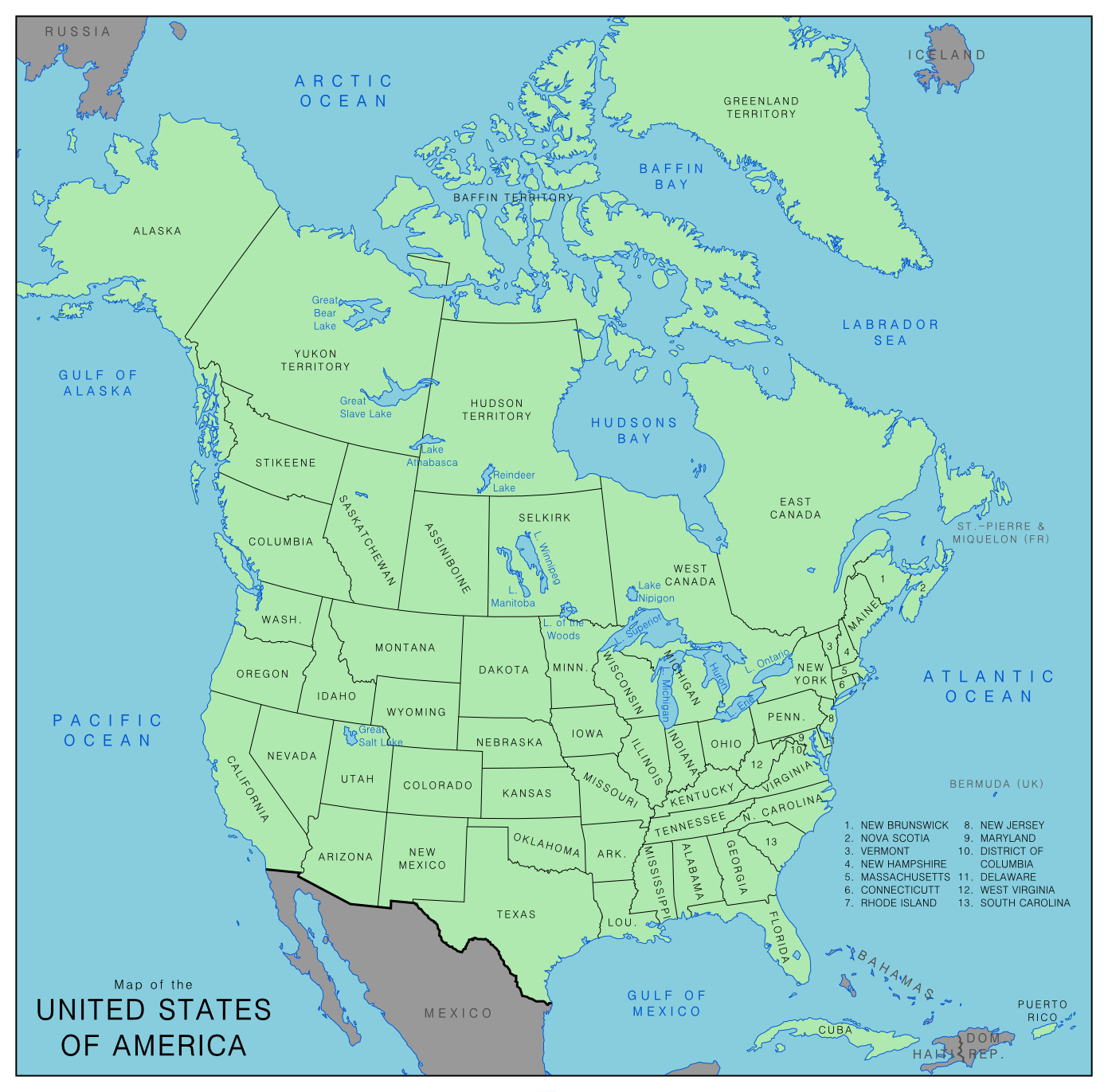
From a thread over in pre-1900.
Is there already a map depicting these states and territories, with the map below for the "old" US?
If not, can anyone create it?

Here is a map of arable land by country as of 2013.
While I like the concept, to be blunt there was zero need to use the Q-BAM for that, the Worlda would have worked just as well while being easier to read an not taken up so much space.

