WIP Map Thread

View attachment 370595

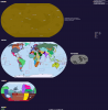
This timeline, so far nicknamed Failure of the House of Brandenburg, details a timeline where Tsarina Elizabeth doesn't die before the end of the Seven Years' War, resulting in a vastly different timeline including the 7 Years' War (probably called the World War ITTL) splitting into two separate wars following the Treaty of Berlin, the Luso-Spanish War and the Franco-British War. There's more details I've worked out but I'm just keeping it short. It's literally almost complete, but I need to add the Five Civilized Tribes onto the map (a task that I'm making way too difficult for my own good). If any of y'all got a suggestion on how I should put 'em on, tell me. Any questions about the timeline and I'll try to answer them.

I really like that North America, what's going on with the 13 Colonies (not to mention the Amerindians getting their own states )?

Bolded part; oddly I think the borders from Glen's "Dominion of Southern America" could work as a consolidation of most Five Civilized Tribes' territory.
 
I really like that North America, what's going on with the 13 Colonies (not to mention the Amerindians getting their own states )

Alright, North America.
Following the Franco-British War, both nations found themselves near broke due to the costly nature of combat. The natural response to this was to get the money from the taxation of colonies. Of course, the colonists much despised the over-taxation, and, in 1768 (3 years following the end of the Franco-British War), the Thirteen Colonies declared independence. A little less than a year later, the Quebecois, humiliated by being defeated by the Brits when they were so closed to winning, decided to join the Revolutionaries and declare independence with the colonists. The native peoples cooperated with the colonists, which nurtured a sense of brotherhood between the revolutionaries and the natives.
Following independence, the Americans, who agreed to protect the Iroquois, established the first Indian State - a state that is entitled to self-rule, but all citizens are US citizens with US rights (including the right to run for presidency). Following the Iroquois, the Five Civilized Tribes ascended into Indian States (which is why I kinda want the actual territories, apologies)
 
@Kekkle thanks for the feedback, looking forward to the finished product. Louisiana also looks interesting!

Also, check here for a more inclusive tribal territory picture.
 
@Kekkle thanks for the feedback, looking forward to the finished product. Louisiana also looks interesting!

Also, check here for a more inclusive tribal territory picture.

Thank you!! Louisiana is a subject I admittedly haven't thought through fully yet, but I'll tackle her sooner or later.
Yea, I have maps of the tribes (example: https://en.wikipedia.org/wiki/Five_Civilized_Tribes), but I more need to wrap my head around transferring it onto a WORLDA. Thank you for showing interest!!
 
Which is better.
This
Global raj WIP.png
Or this
Global raj 2 WIP.png
 
To be honest, I'm not entirely sure what this project of yours is, though it's fascinating nevertheless.

I tend to use Kavraiskiy-VII as my projection of choice. The source image for this current map is here. I don't think I've ever seen it used on another map.

Edit: Misread project as projection. Basically, I'm taking an old near-fantastical map, and re-projecting it to a more usual map projection.
 
Last edited:
technically this is in fact a wip, i still need to get the other planets and moons sorted, and some of venus

upload_2018-2-16_21-29-46.png


The Inner Solar System in Lagos, Luna, Ľvov, and everything in between.

Some notes:
- The US is still under the delusion that it's the world's only superpower
- The Commonwealth is basically where the EU is in 2018
- Nigeria STRONK
- There is an Aquatic Republic of fed up water-adapted genetically-modified humans
- Mars is home to a group of fed-up socialists who left China because it wasn't True Socialist enough
- The POD is technically in the 90's but I've put a massive bloody butterfly net up until 2020
- The Free State of Sapphia is only called that in polite discussion. most people just call it "terfistan" or something similarly fitting
 

Attachments

  • upload_2018-2-16_21-29-35.png
    upload_2018-2-16_21-29-35.png
    426.8 KB · Views: 373
I want to digitise a few maps I have of Nazi Germany.

Here is a WIP of radio/wireless receivers per 100 households (1941). When I'm done I'll add a key, it goes from <50% to >70% at deepest red (white is no data).
I'm not sure the original map maker got the regions right. This is a 1944 basemap I have, and there seem to be a few border oddities here and there.

8foDud4.jpg
 
Top