The NEW Our TimeLine Maps Thread!

Is Afghanistan still accurate showing it in that quadruple sub-division like that? I tried running around the internet to see if the sub-divisions were still comparable, but all I found was that 64% of troops are now US. Would it make more sense to color it all US now? Or are there altered divisions or whatnot?

I'm just attempting to update the map (I grabbed the tacos map, though I edited some colors for my own interests because that EU color is weird and the Koreas were impossible to distinguish) and throw in all the world rebellions.

Thanks for any replies!

It's definitely not. I'm pretty certain the Americans have taken over command of operations in Helmand for example.
 
An update to the map on page 183. I managed to find the exact areas of responsibility for the Norwegians in the British zone in 1947 and 1949 (the 1948 area of responsibility is more approximate than exact) and the approximate areas of responsibility for the Danes in the British zone in 1947 and the exact area of responsibility in 1949. I also added in the annexation of minor border areas by the Dutch in April 1949 (which was returned in the early 1960s). I can take the maps up to 1955 when the occupation officially ended and will post the sources as resources in a next post.

evolution of the occupation zones in germany 1943-1952.png
 
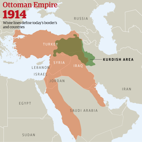
The Kurdish area within the Ottoman Empire and Persia in 1914.
The borders of the Ottoman Empire are not 100% accurate, but I think, the map I found on Google is good enough to be posted here.

Ottomanempire1914map.png
 
That looks suspiciously like the modern borders of the Kurdish-majority areas. Either they haven't moved about at all, or it's a bit of a hack-job.

800px-Kurdish-inhabited_area_by_CIA_%281992%29.jpg
 
Another map generated with gcmap.com. What you're looking at is the initial 1898 Treaty of Paris borders of the Philippines, the extension of the northern border to 21°30'N, the border defined with Malaysia in 1932 and the 1979 presidential decree 1596

w1hfTG3.gif
 
Russia's arctic claims. Sector lines extended to north pole. Made using gcmap.com Coordinates included below map (Using code format alright for posting coordinates?).

oSrXiOb.gif


Code:
Norway - Russia
70°16'28.95"N32°04'23.00"E-73°41'10.85"N37°00'00.00"E-75°11'41.00"N37°00'00.00"E-75°48'00.74"N38°00'00.00"E-78°37'29.50"N38°00'00.00"E-79°17'04.77"N34°59'56.00"E-83°21'07.00"N35°00'00.29"E-84°41'40.67"N32°03'51.36"E-90n32°03'51.36"E

United States - Russia
65°30'N168°58'37"W-65°19'58"N169°21'38"W-65°09'51"N169°44'34"W-64°59'41"N170°07'23"W-64°49'26"N170°30'06"W-64°39'08"N170°52'43"W-64°28'46"N171°15'14"W-64°18'20"N171°37'40"W-64°07'50"N172°00'00"W-63°59'27"N172°18'39"W-63°51'01"N172°37'13"W-63°42'33"N172°55'42"W-63°34'01"N173°14'07"W-63°25'27"N173°32'27"W-63°16'50"N173°50'42"W-63°08'11"N174°08'52"W-62°59'29"N174°26'58"W-62°50'44"N174°44'59"W-62°41'56"N175°02'56"W-62°33'06"N175°20'48"W-62°24'13"N175°38'36"W-62°15'17"N175°56'19"W-62°06'19"N176°13'59"W-61°57'18"N176°31'34"W-61°48'14"N176°49'04"W-61°39'08"N177°06'31"W-61°29'59"N177°23'53"W-61°20'47"N177°41'11"W-61°11'33"N177°58'26"W-61°02'17"N178°15'36"W-60°52'57"N178°32'42"W-60°43'35"N178°49'45"W-60°34'11"N179°06'44"W-60°24'44"N179°23'38"W-60°15'14"N179°40'30"W-60°11'39"N179°46'49"W, 58°58'14"N178°15'05"E-58°57'58"N178°14'37"E-58°48'06"N177°58'14"E-58°38'12"N177°41'53"E-58°28'16"N177°25'34"E-58°18'17"N177°09'18"E-58°08'15"N176°53'04"E-57°58'11"N176°36'52"E-57°48'04"N176°20'43"E-57°37'54"N176°04'35"E-57°27'42"N175°48'31"E-57°17'28"N175°32'28"E-57°07'11"N175°16'27"E-56°56'51"N175°00'29"E-56°46'29"N174°44'32"E-56°36'04"N174°28'38"E-56°25'37"N174°12'46"E-56°15'07"N173°56'56"E-56°04'34"N173°41'08"E-55°53'59"N173°25'22"E-55°43'22"N173°09'37"E-55°32'42"N172°53'55"E-55°21'59"N172°38'14"E-55°11'14"N172°22'36"E-55°00'26"N172°06'59"E-54°49'36"N171°51'24"E-54°38'43"N171°35'51"E-54°27'48"N171°20'20"E-54°16'50"N171°04'50"E-54°05'50"N170°49'22"E-53°54'47"N170°33'56"E-53°43'42"N170°18'31"E-53°32'46"N170°05'29"E-53°21'48"N169°52'32"E-53°10'49"N169°39'40"E-52°59'48"N169°26'53"E-52°48'46"N169°14'12"E-52°37'43"N169°01'36"E-52°26'38"N168°49'05"E-52°15'31"N168°36'39"E-52°04'23"N168°24'17"E-51°53'14"N168°12'01"E-51°42'03"N167°59'49"E-51°30'51"N167°47'42"E-51°19'37"N167°35'40"E-51°11'22"N167°26'52"E-51°12'17"N167°15'35"E-51°09'09"N167°12'00"E-50°58'39"N167°00'00"E, 60°11'39"N179°46'49"W-59°58'22"N179°40'55"W-58°57'18"N178°33'59"E-58°58'14"N178°15'05"E
 
That looks suspiciously like the modern borders of the Kurdish-majority areas. Either they haven't moved about at all, or it's a bit of a hack-job.

The Eastern Kurds (Eastern Turkey, Northern Iraq and Iranian Kurdistan) I don't think actually have moves about very much, there's been immigration to other countries, but most of the internal movement that's lead to noticeable local minority-majority situations has been with the Western Kurds (Central and Western Turkey); there are of course the Khorasani Kurds, but they've been where they are for a very long time.
 
Top