You are using an out of date browser. It may not display this or other websites correctly.
You should upgrade or use an alternative browser.
You should upgrade or use an alternative browser.
The M-BAM Main Thread
- Thread starter Pogoboy20
- Start date
I saw this map you posted on reddit, it has to be one of my favorite maps of all time, my main favorite aspect of it, is that you drew only the areas that are directly inhabited by humans, which is what I am planning to do for my own personal maps.
I want to ask something (in case this thread doesn't crashes my browser lmao): which sources did you use for the human population trails? (this is what I call them. I do not know if they have a specific name), searching "population density" does not really helps since it does not usually shows where humans directly live.
I personally don't really like this since a lot (if not most) of the white areas actually do have significant numbers of inhabitants, who do actually speak languages.Various sources really, there were no good world maps for it so this map was created country by country and we used numerous sources to get the best results.
One note though, the white areas have a population density of 1p/km2 or lower, so they are not uninhabited just have extremely spare population density
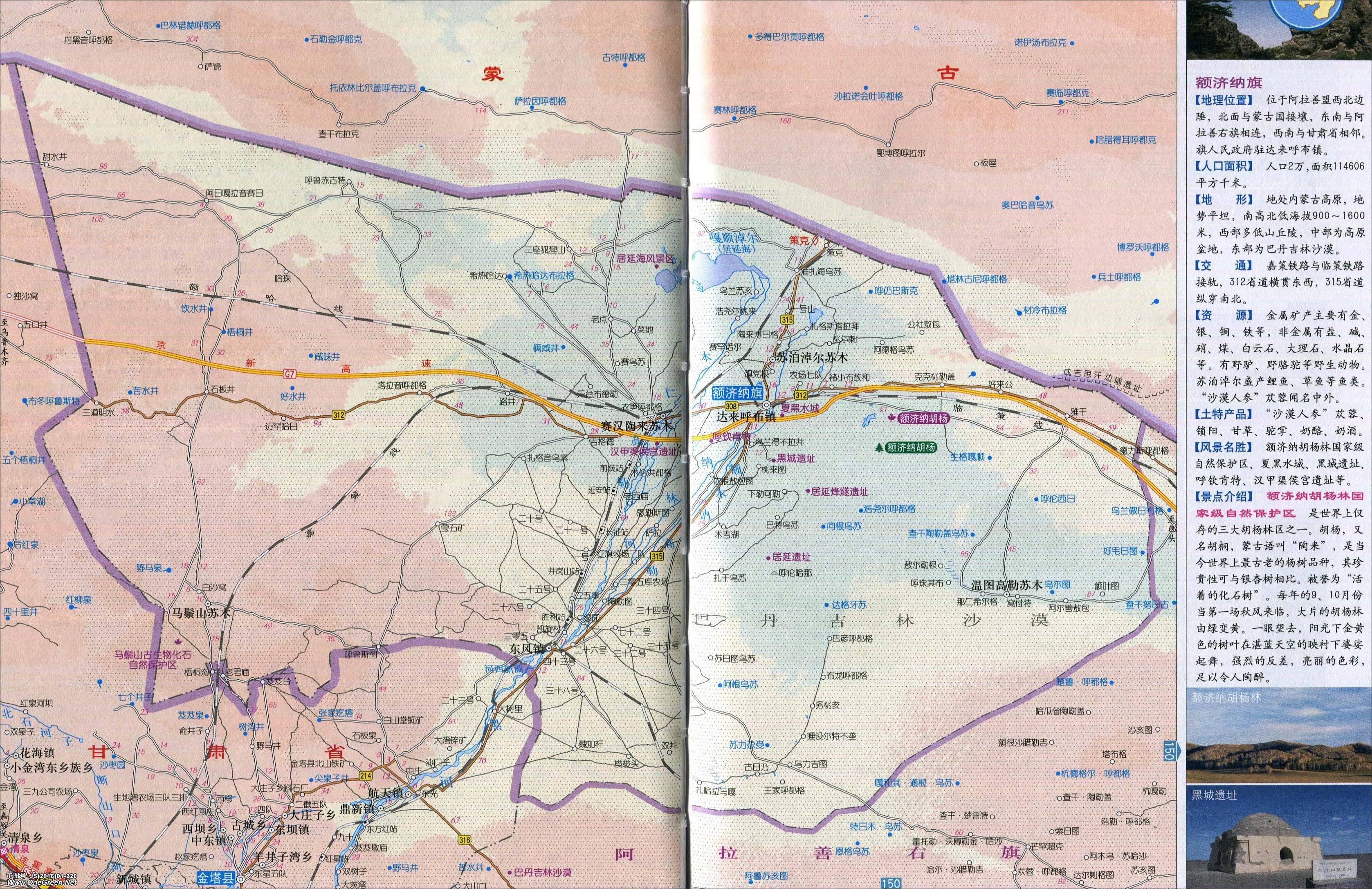
For example this completely blank area is Ejine Banner, which has a population of over 35 thousand. The area of the whole banner is about 115 thousand sq km, so if they were evenly spread out over the area they would indeed be under 1 pop/sq km. However, most of the people in this region are actually concentrated in the central river valley, so that area should probably be coloured in with the Mandarin language.
Looking at the rest of Inner Mongolia, I notice that this map perpetuates a common misconception that most of that region is majority Mongol. This might have been true 150 years ago, but in fact 4/5 of the population are Han. Although it is true that the regions depicted as Mongol in this map are predominantly in the Gobi Desert and therefore low in population density, we can observe that specifically Xilingol League and Alasha League are both shown as majority Mongol across the whole extent shown as densely populated, whereas indicated by census data both are majority Han.
Yea the white area does not show uninhabited land, rather it shows sparsely populated land, alot of ppl on the reddit post got upset to because they misunderstood this.I personally don't really like this since a lot (if not most) of the white areas actually do have significant numbers of inhabitants, who do actually speak languages.
For example this completely blank area is Ejine Banner, which has a population of over 35 thousand. The area of the whole banner is about 115 thousand sq km, so if they were evenly spread out over the area they would indeed be under 1 pop/sq km. However, most of the people in this region are actually concentrated in the central river valley, so that area should probably be coloured in with the Mandarin language.
Looking at the rest of Inner Mongolia, I notice that this map perpetuates a common misconception that most of that region is majority Mongol. This might have been true 150 years ago, but in fact 4/5 of the population are Han. Although it is true that the regions depicted as Mongol in this map are predominantly in the Gobi Desert and therefore low in population density, we can observe that specifically Xilingol League and Alasha League are both shown as majority Mongol across the whole extent shown as densely populated, whereas indicated by census data both are majority Han.
Also the fully coloured areas show a 70% majority or higher while mixed areas are anywhere between 30-70%.
While languages that don't reach a 30% areal majority anywhere aren't shown at all, this is a major shortcoming in the map yes but without this limitiation it would have honestly turned into a never ending rabbithole project for us.
Be very cautious with Chinese statistics on ethnicity in these areas. Some believe that the Chinese overestimate their ethnic and population statistics, similar to how they inflate economic statistics to meet quota goals. In addition, these statistics do not factor in mixed-ethnicity individuals, since the ethnic status of an individual depends on his or her mother or father and individuals can only choose 1 ethnicity on the census. Obviously though, it is the only resource on such a large scale, so it has quite a lot of reliabilityYea the white area does not show uninhabited land, rather it shows sparsely populated land, alot of ppl on the reddit post got upset to because they misunderstood this.
Also the fully coloured areas show a 70% majority or higher while mixed areas are anywhere between 30-70%.
While languages that don't reach a 30% areal majority anywhere aren't shown at all, this is a major shortcoming in the map yes but without this limitiation it would have honestly turned into a never ending rabbithole project for us.
Yea I get that, I won't claim this map to be perfect, theres probably a large number of mistakes, and lack of a proper river map for example made placements difficult in several areas, still though, we did the best we could do with the resources we could find I think, if anyone wants to make changes or improvements to the map by all means, that was my goal by sharing it hereBe very cautious with Chinese statistics on ethnicity in these areas. Some believe that the Chinese overestimate their ethnic and population statistics, similar to how they inflate economic statistics to meet quota goals. In addition, these statistics do not factor in mixed-ethnicity individuals, since the ethnic status of an individual depends on his or her mother or father and individuals can only choose 1 ethnicity on the census. Obviously though, it is the only resource on such a large scale, so it has quite a lot of reliability
")
I just don't see what the point of most of that white is, since most of the white areas are actually inhabited, and it is possible to make meaningful statements about which languages are spoken there.Yea the white area does not show uninhabited land, rather it shows sparsely populated land, alot of ppl on the reddit post got upset to because they misunderstood this.
Also the fully coloured areas show a 70% majority or higher while mixed areas are anywhere between 30-70%.
While languages that don't reach a 30% areal majority anywhere aren't shown at all, this is a major shortcoming in the map yes but without this limitiation it would have honestly turned into a never ending rabbithole project for us.
Are you going to go for the full HRE?Upgraded year 1700 map of Europe with more divisions! (also Poland-Lithuania borderfix)
P.S. - if someone want to help with this timeline, please, I would be glad if someone could do Central and East Asia, not necessary with divisions
Thanks & enjoy doing cool M-BAM maps <3View attachment 868063
I guess I can do so, but I think it'll be uncomfortable to work with it. I think much better to paint it one color and sign "small states". But I can try to do thoAre you going to go for the full HRE?
Are you going to go for the full HRE?
Holy Roman Empire with all states (absolute monstrosity)
Nice job! A few areas are missing, but you're doing a good job so far. Good luck. Maybe you'll make a full m-bam one dayView attachment 868140View attachment 868141
Holy Roman Empire with all states (absolute monstrosity)
So, a common mistake in 1914's Ottoman Empire is Najran: it was its own independent state under the Banu Yam, in southern Arabia, but it is always shown as Ottoman territory. Otherwise, nice map!
Ok, now I know, thanks!So, a common mistake in 1914's Ottoman Empire is Najran: it was its own independent state under the Banu Yam, in southern Arabia, but it is always shown as Ottoman territory. Otherwise, nice map!
Share: