You are using an out of date browser. It may not display this or other websites correctly.
You should upgrade or use an alternative browser.
You should upgrade or use an alternative browser.
Request Maps/Flags Here
- Thread starter Tom Thumb
- Start date
- Status
- Not open for further replies.
Here's one for 1893.I don't suppose anyone has (or knows the location of) a map of the Dutch East Indies showing colonial subdivisions?
Not bothered about the format, just looking for one for reference.
Thanks")
https://upload.wikimedia.org/wikipedia/commons/7/7a/Nederlandsch_indie_1893.jpg
There was a reform in 1938, though.
max schulz
Banned
attention
i have just read the DMZ comic book series i was wondering if you kind fellows can make a map of america in the DMZ comics with alaska hawaii and puerto rico
P.S can one of you also make a map of america in the handmaid's tale book
i have just read the DMZ comic book series i was wondering if you kind fellows can make a map of america in the DMZ comics with alaska hawaii and puerto rico
P.S can one of you also make a map of america in the handmaid's tale book
attention
i have just read the DMZ comic book series i was wondering if you kind fellows can make a map of america in the DMZ comics with alaska hawaii and puerto rico
P.S can one of you also make a map of america in the handmaid's tale book
Theres actually a map of Gilead in the show but its kinda weird, geographically
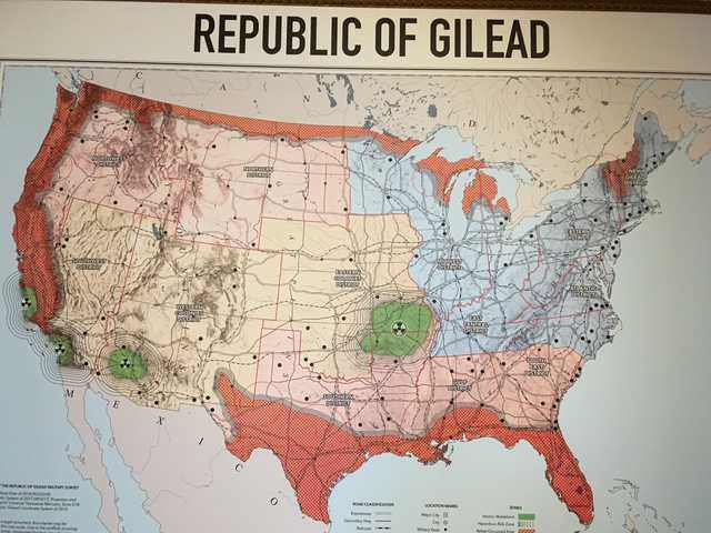
Whats with the long line around Canada...
Theres actually a map of Gilead in the show but its kinda weird, geographically
Whats with the long line around Canada...
rebel (anti-gilead) held territories. Would make sense they would control the border with Canada so as to be able to get supplies from them.
max schulz
Banned
as i said before can one of you alternate histories make a map of america in the dmz comics
if you want something to base of of hear is this maps

the one on top is work in progress so i encourage you to take some creative liberties
if you want something to base of of hear is this maps
the one on top is work in progress so i encourage you to take some creative liberties
max schulz
Banned
if any of you kind map artists want to make a map of america from the DMZ comics i am waiting
max schulz
Banned
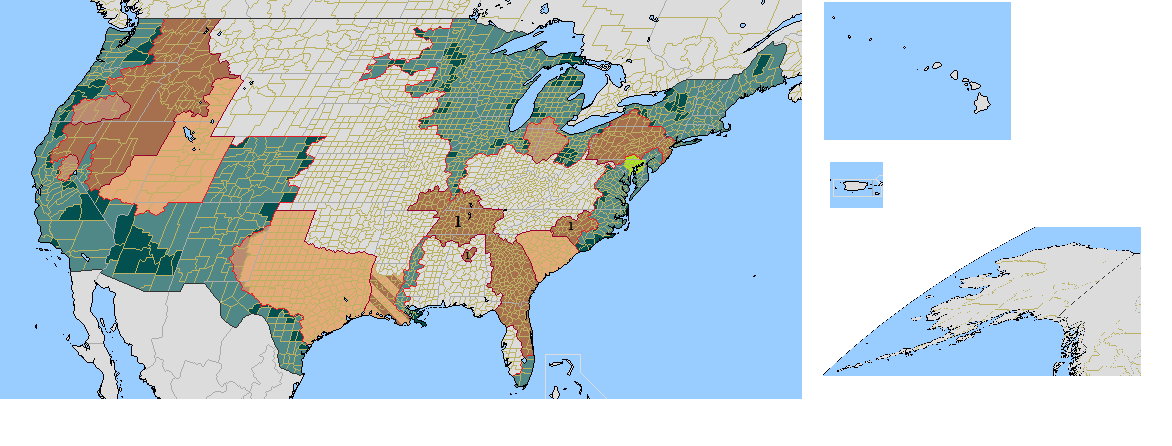
and if you want to know what the colors on the map mean hear is a legend
blue is the usa
dark blue is areas under martial law
light brown are secessionist groups
brown is the free states
and green is the washington exclusion zone
remember this map unfinished and the gray arias are not colored yet and i think that they belong to the free states as for alaska hawaii and puerto rico i still do not know this incomplete map was made by bm2617
New Britain Mapping
Banned
Can I have a request? I want a blank map but with clean regions like this:
But I also want the map to look like something like on a youtuber's stream (the youtuber is Varot) Please provide some maps, thank you
 (Victoria 2 style)
But I also want the map to look like something like on a youtuber's stream (the youtuber is Varot) Please provide some maps, thank you
Does anyone know a map that shows the proposed "Principality of the Pindus" ( //en.m.wikipedia.org/wiki/Principality_of_the_Pindus) that isn't this one:

It only shows the territory of the proposed canton very up-close, and all the city names are (I think) in French, so it's hard to research what territory it would hold exactly, especially the eastern border. If anyone could find a map of the Principality of the Pindus, but maybe with a wider view, like of Greece, the Balkans, or even Europe overall, that'd be great.
It only shows the territory of the proposed canton very up-close, and all the city names are (I think) in French, so it's hard to research what territory it would hold exactly, especially the eastern border. If anyone could find a map of the Principality of the Pindus, but maybe with a wider view, like of Greece, the Balkans, or even Europe overall, that'd be great.
Does anyone know a map that shows the proposed "Principality of the Pindus" ( //en.m.wikipedia.org/wiki/Principality_of_the_Pindus) that isn't this one:
It only shows the territory of the proposed canton very up-close, and all the city names are (I think) in French, so it's hard to research what territory it would hold exactly, especially the eastern border. If anyone could find a map of the Principality of the Pindus, but maybe with a wider view, like of Greece, the Balkans, or even Europe overall, that'd be great.
According to the notice on the lower left, the limit of the territorial claim for Pindus is the line made of plus signs so that the southern part should be excluded as below. The pink part is meant to represent all territories were the vlachs form a majority of the population.
The place names appear to be written in Albanian.
If it helps, the lake called "Janina" in the lower left is Ioannina (Greece). Mekovo near the southern border is Metsovo, Perivoli (center) is also called Perivoli in greek, Grevena (north-western border) is also Grevena and Gramosta (northern border) is mount Gramos. I assume that most other placename should be similar enough to be recognisable.
Nice. Thank you!According to the notice on the lower left, the limit of the territorial claim for Pindus is the line made of plus signs so that the southern part should be excluded as below. The pink part is meant to represent all territories were the vlachs form a majority of the population.
The place names appear to be written in Albanian.
If it helps, the lake called "Janina" in the lower left is Ioannina (Greece). Mekovo near the southern border is Metsovo, Perivoli (center) is also called Perivoli in greek, Grevena (north-western border) is also Grevena and Gramosta (northern border) is mount Gramos. I assume that most other placename should be similar enough to be recognisable.
View attachment 508335
Deleted member 107125
I shall do it!Can someone do a north America worlda map where Canada has Alaska, New York State, and New England, and where a unified Scandinavia has Greenland under its control? This world also has a reverse civil war in which the North Seceded, and won the war, then the former United States existed in the South for a while before collapsing. This would would have a Russian Oregon / Cascadia as some sort of Tsar Exile state, where the Tsars survived and were exiled there, a more of a dutch / German Caribbean instead of a Spanish speaking one. Maybe even go a step further and say that Mexico came into some sort of personal union with Austria or the Hapsburgs and became more German speaking later on. Alternate colonization and alternate wars.
Could someone do 2 versions in which the United States stays in existence in the south, and one where the United States collapses in the south? The Northern States would take the name: American Federal Republic.
Canada would have alternate provinces such as Athabasca. Other territories would include Ungava, Stickeen, Alaska (unless it came under the Tsar Exile state).
Just be a little more specific about the former North
Anyone got a map with 1000 meters sea level rise? Or the highest sea level rise you have. Of course I'm not aiming for realism here
Have a look here: https://www.floodmap.netAnyone got a map with 1000 meters sea level rise? Or the highest sea level rise you have. Of course I'm not aiming for realism here
You can enter any value you want - I tried 10000 m (higher than Mt Everest) and it didn't reject it...
does anyone have a worlda of the fallout series?
Not really any canon details outside of mainland USA in the 23rd century. Even a map of North America would would leave a lot of area blank.
- Status
- Not open for further replies.
Share: