The word you're looking for is "Long Island"Can one of you fine souls create a flag for this proposed independent New York City? It's territory is in blue
You are using an out of date browser. It may not display this or other websites correctly.
You should upgrade or use an alternative browser.
You should upgrade or use an alternative browser.
Request Maps/Flags Here
- Thread starter Tom Thumb
- Start date
- Status
- Not open for further replies.
I suppose you're right, though the base image specifically stated the proposed land as "An Independent New York City"The word you're looking for is "Long Island"
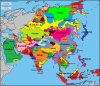
Do you need that particular map, or would it be okay for someone to make it? If the latter, is the entire world part of the USSR, or just most of it?I'm looking for a map, I think it was a Q-BAM, about a world-spanning Soviet Union with all of the Earth divided into ethnic groups and not just erasing some borders between countries.
Btw, I'm new to this, so tell me if I'm doing anything wrong.
Do you need that particular map, or would it be okay for someone to make it? If the latter, is the entire world part of the USSR, or just most of it?
Btw, I'm new to this, so tell me if I'm doing anything wrong.
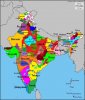
It is mostly because I remembered that one of them had ethnolinguistic administrative divisions for India and I wished to have something to compare to my ideas of the borders of several Dominions in India.
What were the search terms? We might be able to narrow it down.It is mostly because I remembered that one of them had ethnolinguistic administrative divisions for India and I wished to have something to compare to my ideas of the borders of several Dominions in India.
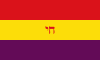
Would someone be able to please make two versions of the second spanish republic flag (without the crest in the middle) and add for one, ספרד, in the middle with the same color of the top red, and another with the chai symbol colored the same way and in the middle? And the middle text would be bolded please? The bigger the flag, the better. I' I really want to get a sticker of one or the other for my laptop.
I've been thinking of an alternate history where either sephardic jews were never exiled and played a strong role in the spanish civil war where the republicans won or a history where part of the second spanish republic's goal was to undo the damage of the exile of sephardic jews and the persecution of anusim, and subsequently you had a lot of sephardic jews from salonika, rhodes, turkey, argentina, the netherlands, belgium, the uk, and the usa traveling to spain and making their own international brigades and working in parallel with crypto-jewish remnants (both in iberia and elsewhere) coming out into the open and out of hiding, and in either timeline, a sephardic version of revolutionary leftist politics forming and playing a similar role that the ashkenazi working class played in a lot of revolutionary politics.
I've been thinking of an alternate history where either sephardic jews were never exiled and played a strong role in the spanish civil war where the republicans won or a history where part of the second spanish republic's goal was to undo the damage of the exile of sephardic jews and the persecution of anusim, and subsequently you had a lot of sephardic jews from salonika, rhodes, turkey, argentina, the netherlands, belgium, the uk, and the usa traveling to spain and making their own international brigades and working in parallel with crypto-jewish remnants (both in iberia and elsewhere) coming out into the open and out of hiding, and in either timeline, a sephardic version of revolutionary leftist politics forming and playing a similar role that the ashkenazi working class played in a lot of revolutionary politics.


This oneDo you have any base map in particular?
And this one:
Is it this one?I'm looking for a map, I think it was a Q-BAM, about a world-spanning Soviet Union with all of the Earth divided into ethnic groups and not just erasing some borders between countries.
Attachments

I'm looking for a high quality uncurved mercator map (I don't care if it looks mercator-warped), made with only two colours that shows all the states/provinces/regions in the world and is also easily editable in something like Paint.NET.
I've been using Wikipedia's map and it's almost perfect except that it's too small, curved, and only shows nations.
I have tried a few times to make this map and I always run into the same issue.
Maps that show states and such suffer from unaligned distortion. When I look at a map of Australia that shows states, for example, the map's centre is focused on the middle of Australia, not the equator. This makes the Northern tips of Queensland and Tasmania look wrong when up against a proper world map. This means it's impossible to line up without manually warping the image and I don't know how to do that.
Page 126 has an almost perfect map.
It's slightly too small, not to sound like I'm overbearing but 10,000 across is the range I'm looking at.
It has that weird island zoom feature that I barely understand.
It's curved.
It has more than 2 colours.
Last edited:
- Status
- Not open for further replies.
Share: