You're more likely to take Minnesota and Vermont.We’ll get Maine one day.... just you wait...
You are using an out of date browser. It may not display this or other websites correctly.
You should upgrade or use an alternative browser.
You should upgrade or use an alternative browser.
Proposals and War Aims That Didn't Happen Map Thread
- Thread starter Beedok
- Start date
There's no way this could possibly go wrong.Apparently there were proposals to crown Danish Prince Harald as king of an Independent Macedonia
View attachment 690771
It worked for Greece, so why not?Apparently there were proposals to crown Danish Prince Harald as king of an Independent Macedonia
View attachment 690771
Given the source (The Macedonia Times is a nationalist outlet) and the scant evidence presented apart from one brief newspaper article, this is extremely dubious. No Balkan country was ever seriously interested in an 'Independent Macedonia': for Bulgaria, this was just a means and an intermediate stage to annexing Macedonia to itself a la Eastern Rumelia, and for Greece (and to a lesser extent Serbia) the idea was anathema in any shape or form.
This would've been far more sensible than the OTL borders of the Second Polish Republic...
I admire Pilsudski, but his concept of a vast Poland somewhat akin to a reincarnated PLC was simply unworkable in the long run...
Well I think his "concept of Poland" wasn´t "concept of Poland", as far is I know (even if in his "non-Poland" would be Poles probably dominant)This would've been far more sensible than the OTL borders of the Second Polish Republic...
I admire Pilsudski, but his concept of a vast Poland somewhat akin to a reincarnated PLC was simply unworkable in the long run...
Well, the only real difference here is the lack of a Belarusian minority, the Ukrainian Ruthenians would still be present here and probably still face a lack of state focus by the Polish government.This would've been far more sensible than the OTL borders of the Second Polish Republic...
I admire Pilsudski, but his concept of a vast Poland somewhat akin to a reincarnated PLC was simply unworkable in the long run...
That, unfortunately, is true... but at least the whole of Galicia had been a single, cohesive administrative entity under A-H, and there were sizable "pockets" of Polish majority east of the San, even if eastern Galicia as a whole was majority Ruthenian...Well, the only real difference here is the lack of a Belarusian minority, the Ukrainian Ruthenians would still be present here and probably still face a lack of state focus by the Polish government.
Also - happy Lithuanian noises.Well, the only real difference here is the lack of a Belarusian minority, the Ukrainian Ruthenians would still be present here and probably still face a lack of state focus by the Polish government.
I wouldn't be too sure... Looks like they didn't mark the border between Lithuania and RussiaAlso - happy Lithuanian noises.

That is true.I wouldn't be too sure... Looks like they didn't mark the border between Lithuania and Russia
Still, Poland doesn't have Vilnius, so it isn't all bad, by Lithuanian standards.
Implying the Soviets still keep ssrs relatively ethnic in their border makeup, Vilnius would probably end up being Belarusian.That is true.
Still, Poland doesn't have Vilnius, so it isn't all bad, by Lithuanian standards.
Implying the Soviets still keep ssrs relatively ethnic in their border makeup, Vilnius would probably end up being Belarusian.
Counterpoint: Lit-Bel SSR.
I've been reading the findings of the American Arbitral Award of the President of the United States of America Woodrow Wilson: Full Report of the Committee upon the Arbitration of the Boundary Between Turkey and Armenia, which was the basis for the whole concept of "Wilsonian Armenia". This is part of a small side-project surrounding the idea of such an Armenia's actual survival in the wake of WWI. However, an interesting side-project, or ought I say a side-side-project, concerns the port city of Batum.
Of the schemes to grant Armenia access to the Black Sea, two were initially proposed by the allied powers after WWI. The first was that Batum ought to become an international / free port. Not dissimilar to ideas surrounding Trieste or Danzig, the idea was that Batum would become an international territory or condominium which could be used not only by Armenia, but by Georgia, Azerbaijan and Persia. Below is my best approximation of the boundaries of such a micro-state: The dotted line represents Batum Oblast (the maximum area that could be allotted to Batum) and the solid line represents the most desirable boundaries (according to the Americans).

However, this proposal was not taken up; chiefly on the grounds that such a port could only ever serve "Russian" Armenia, and had no commercial links whatever to Erzurum, Erzincan or other settlements in "Ottoman" Armenia - meaning the economic, industrial and social divisions that already existed would only widen with Batum serving as Armenia's main port. Furthermore, though Georgia at the time was amenable to Armenian interests in this direction, the Americans of the Committee upon the Arbitration of the Boundary Between Turkey and Armenia had no confidence this would last, especially with the Bolsheviks cascading into the region.
The second main proposal prior to the work of the Committee was that a semi-autonomous Lazistan would comprise Armenia's coastline. However the ports of Lazistan were small and at that time unusable for much of the year, and it was considered entirely unfeasible to build a railway into Lazistan (the Pontic alps being in the way).
It was eventually decided that a substantial part of Trebizond Vilayet would also be adjoined to Armenia, despite the fact few Armenians lived in the region and both Trebizond's Turks and Greeks were opposed to such a move. This was decided upon by the Committee upon the Arbitration of the Boundary Between Turkey and Armenia on purely economic grounds, though it is amusing to note that even the city of Trebizond was adjudged incapable of serving as an independent Armenia's main port (again, as no rail line could connect Trebizond to interior cities) - Tirebolu would instead serve as Armenia's port.
Or it would have, had Wilsonian Armenia survived into the interwar period.
Of the schemes to grant Armenia access to the Black Sea, two were initially proposed by the allied powers after WWI. The first was that Batum ought to become an international / free port. Not dissimilar to ideas surrounding Trieste or Danzig, the idea was that Batum would become an international territory or condominium which could be used not only by Armenia, but by Georgia, Azerbaijan and Persia. Below is my best approximation of the boundaries of such a micro-state: The dotted line represents Batum Oblast (the maximum area that could be allotted to Batum) and the solid line represents the most desirable boundaries (according to the Americans).
However, this proposal was not taken up; chiefly on the grounds that such a port could only ever serve "Russian" Armenia, and had no commercial links whatever to Erzurum, Erzincan or other settlements in "Ottoman" Armenia - meaning the economic, industrial and social divisions that already existed would only widen with Batum serving as Armenia's main port. Furthermore, though Georgia at the time was amenable to Armenian interests in this direction, the Americans of the Committee upon the Arbitration of the Boundary Between Turkey and Armenia had no confidence this would last, especially with the Bolsheviks cascading into the region.
The second main proposal prior to the work of the Committee was that a semi-autonomous Lazistan would comprise Armenia's coastline. However the ports of Lazistan were small and at that time unusable for much of the year, and it was considered entirely unfeasible to build a railway into Lazistan (the Pontic alps being in the way).
It was eventually decided that a substantial part of Trebizond Vilayet would also be adjoined to Armenia, despite the fact few Armenians lived in the region and both Trebizond's Turks and Greeks were opposed to such a move. This was decided upon by the Committee upon the Arbitration of the Boundary Between Turkey and Armenia on purely economic grounds, though it is amusing to note that even the city of Trebizond was adjudged incapable of serving as an independent Armenia's main port (again, as no rail line could connect Trebizond to interior cities) - Tirebolu would instead serve as Armenia's port.
Or it would have, had Wilsonian Armenia survived into the interwar period.
Well it's certainly interesting what would've happened if many of the proposals at the Peace Conference would be accepted, and if they are accepted, they actually be fulfilled. Turkey really wasn't all too connected with itself before a certain electrician-turned prime minister came along. Maybe Armenia would have built a railroad or other road to Trebizond if they did, or maybe the Pontus Greek Proposal would've gone throughI've been reading the findings of the American Arbitral Award of the President of the United States of America Woodrow Wilson: Full Report of the Committee upon the Arbitration of the Boundary Between Turkey and Armenia, which was the basis for the whole concept of "Wilsonian Armenia". This is part of a small side-project surrounding the idea of such an Armenia's actual survival in the wake of WWI. However, an interesting side-project, or ought I say a side-side-project, concerns the port city of Batum.
Of the schemes to grant Armenia access to the Black Sea, two were initially proposed by the allied powers after WWI. The first was that Batum ought to become an international / free port. Not dissimilar to ideas surrounding Trieste or Danzig, the idea was that Batum would become an international territory or condominium which could be used not only by Armenia, but by Georgia, Azerbaijan and Persia. Below is my best approximation of the boundaries of such a micro-state: The dotted line represents Batum Oblast (the maximum area that could be allotted to Batum) and the solid line represents the most desirable boundaries (according to the Americans).
However, this proposal was not taken up; chiefly on the grounds that such a port could only ever serve "Russian" Armenia, and had no commercial links whatever to Erzurum, Erzincan or other settlements in "Ottoman" Armenia - meaning the economic, industrial and social divisions that already existed would only widen with Batum serving as Armenia's main port. Furthermore, though Georgia at the time was amenable to Armenian interests in this direction, the Americans of the Committee upon the Arbitration of the Boundary Between Turkey and Armenia had no confidence this would last, especially with the Bolsheviks cascading into the region.
The second main proposal prior to the work of the Committee was that a semi-autonomous Lazistan would comprise Armenia's coastline. However the ports of Lazistan were small and at that time unusable for much of the year, and it was considered entirely unfeasible to build a railway into Lazistan (the Pontic alps being in the way).
It was eventually decided that a substantial part of Trebizond Vilayet would also be adjoined to Armenia, despite the fact few Armenians lived in the region and both Trebizond's Turks and Greeks were opposed to such a move. This was decided upon by the Committee upon the Arbitration of the Boundary Between Turkey and Armenia on purely economic grounds, though it is amusing to note that even the city of Trebizond was adjudged incapable of serving as an independent Armenia's main port (again, as no rail line could connect Trebizond to interior cities) - Tirebolu would instead serve as Armenia's port.
Or it would have, had Wilsonian Armenia survived into the interwar period.
According to the same document(s), the plan was to construct a railway to Tirebolu. Trebizond was hemmed in by the Pontic Alps, making a rail connection financially impossible (especially for a nascent republic). Tirebolu apaprently had better pre-existing connections with the Erzurum/Erzincan/Bayburt region.Well it's certainly interesting what would've happened if many of the proposals at the Peace Conference would be accepted, and if they are accepted, they actually be fulfilled. Turkey really wasn't all too connected with itself before a certain electrician-turned prime minister came along. Maybe Armenia would have built a railroad or other road to Trebizond if they did, or maybe the Pontus Greek Proposal would've gone through
The Pontic Greek proposal stood no chance. Again, according to this American source, when Venezilos rejected Pontus as being too isolated (and impossible for Greece to defend against a vengeful Turkey) it was apparently the wish of the Pontic Greeks to remain as an autonomous part of Turkey. It was their least favourite idea to split the region between two countries (Turkey & Armenia), especially as it wasn't clear that Armenia would be any more amenable to Greek interests than Turkey was.
You can take that apparent wish with a grain of salt - it is just as likely Venezilos wanted Pontus to remain a part of Turkey so all the Pontic Greeks would have to leave the region - and conveniently populate the abandoned farms and homes of evicted Turks in Macedonia & Thrace. Depends how cynical you are, I guess.
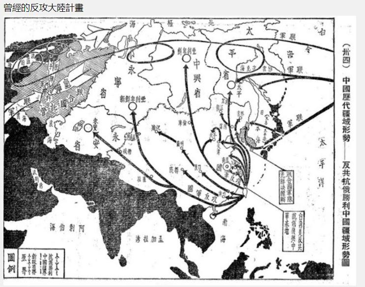
"The Chinese territory after the victory against Communists and Russian" -- Chiang kai-shek's ultimate "plan" to retake China and after
Supposedly this is an authentic and very ambitious Chinese war plans map. Found via Tumblr in the collection of the National Museum for Taiwanese History. If anyone can read traditional Chinese, maybe the notes for the four states/zones of expansion in the former Soviet Union might reveal some interesting details.
Share: