Planetocopia Map Thread

q0bc3x3q1wzc1.jpeg

I did an expanded Köppen-Geiger climate key, because…why not?

For clarification, X type climates have at least part of the year with monthly averages surpassing 45C, at which point photosynthesis for Earth-based plants becomes functionally impossible, and Xx is like that year round, being uninhabitable for anything except microbes at best, regardless of humidity.
 
Well, the small z on those signifies that the warmest month in those zones averages at least 30C instead of the standard “hot summer” 22C cutoff point, signifying very hot summers (or hyperthermal, though the big Z is places like that in all 12 months) along with winters too cool to be considered tropical but too warm to be continental. A similar deal is with the hypercontinental climates on the right, which frankly are convoluted and sound horrendous to live in. But high obiquity worlds would face this at high latitudes
What do you mean by "extrreme" for the mention of extreme climates in the temperate ones. This I'm legit curious about. 🍿
 
Last edited:
Well, the small x on those signifies that the warmest month in those zones averages at least 30C instead of the standard “hot summer” 22C cutoff point, signifying very hot summers along with winters too cool to be considered tropical. A similar deal is with the hypercontinental climates on the right, which frankly are convoluted and sound horrendous to live in. But high obiquity worlds would face this at high latitudes
Good lord. This makes some of the hypothetical climate zones in his obliquity/eccentricity maps not only make more sense but become far more horrifying in context.
 
So, I tried to Simulate Brazil but with way less erosion, like 7.6 times erosion throughout the building of the Andes to try and simulated less erosion under desert conditions and I knew there was a chance for an introgression but I didn't think it'll pass both the high that separated the Pebas from Venezuela and Venezuela from the Old world.

I calculated the less sedimentation and the used a dynamic topography mask that should roughly simulate the shape of the bedrock beneath sediment, over modern topography at a transpiracy that got me the lowest point I calculated. If this method is faulty and you know a better one, gib advice.

vnrrwm2ibe0d1.png


It is slightly below the Jaredia sea level we're using but I checked another way and it'll have to be like, Last Glacial Maximum levels for this not to be this not to be under water. I guess given that if conditions were like this, the desert wouldn't be a thing in the first place I have lee way to edit it until it is mostly back to dry land.

But yeah, Desert Brazil turns into an Inland Sea is the summary.

Edit

Oh, I see what the problem was. The Orinoco is Sealevel and by the very nature of its erosion, deposition and sedimentation, it'll always be sealevel. Now, I don't know what to do about it, simply importing a Sea level and slightly above layer would look weird. Uh....
 
Last edited:
Screenshot 2024-05-14 at 15-14-36 Evolution of the Chinese Coastline 19000 BC-2020 MAJOR ERRORS.png

Screenshot 2024-05-14 at 15-14-30 Evolution of the Chinese Coastline 19000 BC-2020 MAJOR ERRORS.png


Later I am going to redraw the coast of China to follow this. I get glacier pressure didn't affect it but like with Doggerland and the Eridanos, it was built up by deposition from a growing mountain and if Jaredia is as climatically stable as they say it should be, like stable enough for the tip of South Africa to remian unfrozen for millions of years, then this deposition should be able to happen over stable sea levels and never be lost to sea level rise, like basically the same reason Doggerland survives in TTL, as well.
 
View attachment 906603
View attachment 906604

Later I am going to redraw the coast of China to follow this. I get glacier pressure didn't affect it but like with Doggerland and the Eridanos, it was built up by deposition from a growing mountain and if Jaredia is as climatically stable as they say it should be, like stable enough for the tip of South Africa to remian unfrozen for millions of years, then this deposition should be able to happen over stable sea levels and never be lost to sea level rise, like basically the same reason Doggerland survives in TTL, as well.
Yeah, quite similar to how the eridanos formed doggerland on the continental shelf even before the ice age.

1-s2.0-S0264817218303465-gr13.jpg
 
Anybody know how to Create HD Rebound GreenLand Map from Image Data?.
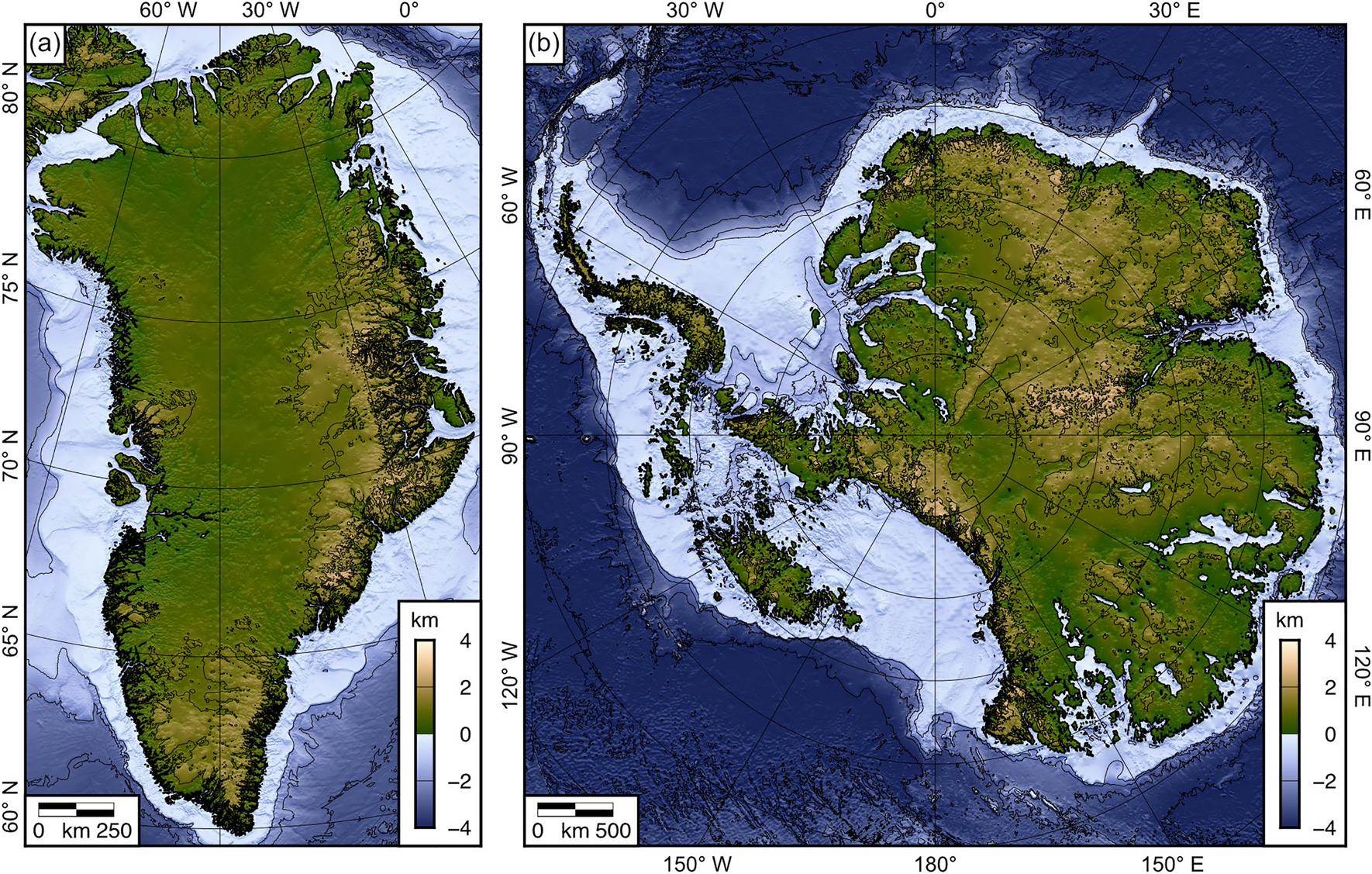
So, this famous study https://www.nature.com/articles/s41598-022-15440-y#Fig3 provided its data source as this https://arcticdata.io/catalog/view/doi:10.18739/A2280509Z however, of all the image data provided none is of the final reconstruction just of the data used to do the reconstruction. So, does anyone know how I can combine these images to generate a higher quality version of this? https://media.springernature.com/fu...bjects/41598_2022_15440_Fig5_HTML.png?as=webp

The extracted .TIFFs


View attachment 906603
View attachment 906604

Later I am going to redraw the coast of China to follow this. I get glacier pressure didn't affect it but like with Doggerland and the Eridanos, it was built up by deposition from a growing mountain and if Jaredia is as climatically stable as they say it should be, like stable enough for the tip of South Africa to remian unfrozen for millions of years, then this deposition should be able to happen over stable sea levels and never be lost to sea level rise, like basically the same reason Doggerland survives in TTL, as well.
Eh, I wouldn't trust that map too much.
 
@Linbot Well, those links broke cuz of discord but I managed to get through that. Now, I am on the point of
Yo, do you know of a way for me to merge these two images.
Lowland.png

Highland.png


Where the brightest points on the resultant map would be equal to the brightest point on the bottom map, while the dimmest value of the top map be the darkest colour range in the resultant map and everything else, some graduation between both.


How to recreate the image below, using the .TIFFs, so image data from the study to construct a fully Isostatically rebounded Greenland.
41598_2022_15440_Fig5_HTML.png


The Image data in 5000 pixels, equirectangular.

Incase the links don't load well, here's a link to the full album. With transpirent backgrounds.

7CkRI3e

JfP6zQ5

M8QTg45

icuQa1y

GSweQSW

rDSqv0N

hYEgRHi

CZybYri

kJXJ4gi

41598_2022_15440_Fig5_HTML.png

xQP7cvK

J7oBUXG

snjtMXJ

eiNjR1A

wTYruHI

5fbtkck

t199SQN
 
Last edited:
You know, anyone know how they make those pictures where they average hundred of faces together?. Especially if its a way to do it with like, gimp, it'll be greatly appreciated.
 
So, as the Pebas would most certainly be a desert and an endorheic basin, anybody know how one can calculate how large of a lake it'll leave at the bottom of the basin?.
 
@Linbot Well, those links broke cuz of discord but I managed to get through that. Now, I am on the point of


How to recreate the image below, using the .TIFFs, so image data from the study to construct a fully Isostatically rebounded Greenland.
41598_2022_15440_Fig5_HTML.png


The Image data in 5000 pixels, equirectangular.

Incase the links don't load well, here's a link to the full album. With transpirent backgrounds.

7CkRI3e

JfP6zQ5

M8QTg45

icuQa1y

GSweQSW

rDSqv0N

hYEgRHi

CZybYri

kJXJ4gi

41598_2022_15440_Fig5_HTML.png

xQP7cvK

J7oBUXG

snjtMXJ

eiNjR1A

wTYruHI

5fbtkck

t199SQN
I've seen a very rough formula for isostatic rebound online: for each point on earth, when all the above ice is gone, the bedrock raises by 1/3 of the above ice thickness.

There are also very nice maps of rebounded Antarctica there, but they will have to be reprojected to equator-centered equirectangular.
Antarctica_without_Ice_Landraise_Sealevelraise033.PNG
Oh, we actually have already fixed Jaredia's Antarctica. I was lucky that someone joined for a while that had been doing an Antarctica project for a while. As for me, I managed a rough construction of the Oligocene (so like 2.5 mil yrs ago) topography of the glaciated north, shifted to modern coastline and heigh curves. I am hoping that if we can find a way to construct the greenland elevation map, we can use the non-ice exclusive data to put on Greenland of this map and create something close to a never glaciated Greenland.

t2ad1hs7d12d1.png
 
Top